Crawford County, Pennsylvania

Last updated

Crawford County
Crawford County Pennsylvania Courthouse.jpg
The Crawford County Courthouse in Meadville
Flag of Crawford County, Pennsylvania.png
Crawford County PA seal.jpg
Map of Pennsylvania highlighting Crawford County.svg
Location within the U.S. state of Pennsylvania
Pennsylvania in United States.svg
Pennsylvania's location within the U.S.
Coordinates: 41°41′N80°07′W / 41.68°N 80.11°W / 41.68; -80.11
CountryFlag of the United States.svg United States
StateFlag of Pennsylvania.svg  Pennsylvania
FoundedMarch 12, 1800
Named for William Crawford
Seat Meadville
Largest cityMeadville
Area
  Total1,038 sq mi (2,690 km2)
  Land1,012 sq mi (2,620 km2)
  Water25 sq mi (60 km2)  2.4%
Population
 (2020)
  Total83,938
  Density81/sq mi (31/km2)
Time zone UTC−5 (Eastern)
  Summer (DST) UTC−4 (EDT)
Congressional district 16th
Website www.crawfordcountypa.net
DesignatedMay 12, 1982 [1]

Crawford County is a county in the Commonwealth of Pennsylvania. As of the 2020 census, the population was 83,938. [2] Its county seat is Meadville. [3] The county was created on March 12, 1800, from part of Allegheny County and named for Colonel William Crawford. [4] The county is part of the Northwest Pennsylvania region of the state. [lower-alpha 1]

Contents

Crawford County comprises the Meadville, PA Micropolitan Statistical Area, which is also included in the Erie-Meadville, PA Combined Statistical Area.

Geography

According to the U.S. Census Bureau, the county has a total area of 1,038 square miles (2,690 km2), of which 1,012 square miles (2,620 km2) is land and 25 square miles (65 km2) (2.4%) is water. [5] It has a warm-summer humid continental climate (Dfb) and average monthly temperatures in Meadville range from 24.9 °F in January to 69.5 °F in July, while in Titusville they range from 24.2 °F in January to 68.8 °F in July. [6]

Adjacent counties

National protected area

State protected area

Pymatuning State Park is on Pymatuning Reservoir.

Major highways

Demographics

Historical population
CensusPop.Note
1800 2,346
1810 6,178163.3%
1820 9,39752.1%
1830 16,03070.6%
1840 31,72497.9%
1850 37,84919.3%
1860 48,75528.8%
1870 63,83230.9%
1880 68,6077.5%
1890 65,324−4.8%
1900 63,643−2.6%
1910 61,565−3.3%
1920 60,667−1.5%
1930 62,9803.8%
1940 71,64413.8%
1950 78,94810.2%
1960 77,956−1.3%
1970 81,3424.3%
1980 88,8699.3%
1990 86,169−3.0%
2000 90,3674.9%
2010 88,765−1.8%
2020 83,938−5.4%
[7]

As of the 2000 census, there were 90,366 people, 34,678 households, and 23,858 families residing in the county. [8] The population density was 89 people per square mile (34 people/km2). There were 42,416 housing units at an average density of 42 units per square mile (16/km2). The racial makeup of the county was 97.00% White, 1.59% Black or African American, 0.20% Native American, 0.28% Asian, 0.03% Pacific Islander, 0.13% from other races, and 0.77% from two or more races. 0.59% of the population were Hispanic or Latino of any race. 45.1% English or Welsh, 10.9% American, 10.3% were of German, 8.2% Irish, 7.8% Scotch-Irish or Scottish, 3.8% Italian 2.6% Dutch, and 2.3% French ancestry.

There were 34,678 households, out of which 30.40% had children under the age of 18 living with them, 55.60% were married couples living together, 9.20% had a female householder with no husband present, and 31.20% were non-families. 26.20% of all households were made up of individuals, and 11.60% had someone living alone who was 65 years of age or older. The average household size was 2.50 and the average family size was 3.01.

In the county, the population was spread out, with 24.70% under the age of 18, 9.20% from 18 to 24, 26.60% from 25 to 44, 23.90% from 45 to 64, and 15.60% who were 65 years of age or older. The median age was 38 years. For every 100 females, there were 94.80 males. For every 100 females age 18 and over, there were 90.80 males.

2020 census

Crawford County Racial Composition [9]
RaceNum.Perc.
White (NH)77,34792.14%
Black or African American (NH)1,4961.8%
Native American (NH)1090.13%
Asian (NH)3650.43%
Pacific Islander (NH)260.03%
Other/Mixed (NH)3,3544%
Hispanic or Latino 1,2411.48%

Micropolitan Statistical Area

The United States Office of Management and Budget [10] has designated Crawford County as the Meadville, PA Micropolitan Statistical Area (µSA). As of the 2010 census [11] the micropolitan area ranked 5th most populous in the State of Pennsylvania and the 52nd most populous in the United States with a population of 88,765. Crawford County is also a part of the Erie-Meadville, PA Combined Statistical Area (CSA), which combines the population of both Crawford County and the Erie County areas. The Combined Statistical Area ranked 7th in the State of Pennsylvania and 102nd most populous in the United States with a population of 369,331.

Map of the Erie-Meadville, PA Combined Statistical Area (CSA), composed of the following parts:
.mw-parser-output .legend{page-break-inside:avoid;break-inside:avoid-column}.mw-parser-output .legend-color{display:inline-block;min-width:1.25em;height:1.25em;line-height:1.25;margin:1px 0;text-align:center;border:1px solid black;background-color:transparent;color:black}.mw-parser-output .legend-text{}
Erie, PA Metropolitan Statistical Area
Meadville, PA Micropolitan Statistical Area Erie-Meadville, PA CSA 2014.jpg
Map of the Erie-Meadville, PA Combined Statistical Area (CSA), composed of the following parts:

Government

United States presidential election results for Crawford County, Pennsylvania [12]
Year Republican Democratic Third party
No.%No.%No.%
2020 28,56167.82%12,92430.69%6291.49%
2016 24,98766.08%10,97129.01%1,8554.91%
2012 20,90158.75%13,88339.02%7912.22%
2008 20,75054.17%16,78043.80%7772.03%
2004 21,96557.32%16,01341.79%3440.90%
2000 18,85856.58%13,25039.76%1,2203.66%
1996 14,65946.62%12,94341.16%3,84412.22%
1992 14,11240.75%12,81337.00%7,70322.25%
1988 17,24956.32%13,02142.51%3581.17%
1984 20,18160.80%12,79238.54%2220.67%
1980 16,55253.55%11,77838.11%2,5798.34%
1976 15,30149.99%14,71248.06%5971.95%
1972 18,39364.38%9,37132.80%8052.82%
1968 14,99153.11%11,34540.19%1,8906.70%
1964 10,66436.78%18,21262.82%1150.40%
1960 18,75460.68%12,05038.99%1020.33%
1956 18,88766.65%9,34632.98%1040.37%
1952 19,07965.49%9,87433.89%1810.62%
1948 14,16160.69%9,17439.31%00.00%
1944 15,20561.83%9,21637.48%1700.69%
1940 15,89160.62%10,19738.90%1250.48%
1936 14,46351.31%12,78845.37%9383.33%
1932 10,91851.72%9,38244.44%8113.84%
1928 17,07271.17%6,71828.00%1990.83%
1924 10,91863.09%2,96917.16%3,41819.75%
1920 10,03262.31%4,17525.93%1,89211.75%
1916 5,48744.18%5,81446.81%1,1199.01%
1912 2,49720.56%3,90832.17%5,74247.27%
1908 7,67952.58%5,66838.81%1,2588.61%
1904 7,45059.03%3,64528.88%1,52512.08%
1900 7,70549.97%7,00045.40%7134.62%
1896 7,85147.26%8,38350.47%3772.27%
1892 7,15247.30%6,16640.78%1,80411.93%
1888 8,04053.59%5,96439.75%9996.66%

Voter registration

Chart of Voter Registration

   Republican (59.17%)
   Democratic (29.03%)
   Independent (8.11%)
   Other Parties (3.69%)

As of February 6, 2024, there were 49,786 registered voters in Crawford County. [13]

County commissioners

Other county officials

Pennsylvania Senate

DistrictSenatorParty
50 Michele Brooks Republican

Pennsylvania House of Representatives

DistrictRepresentativeParty
6 Brad Roae Republican
17 Parke Wentling Republican
65 Kathy Rapp Republican

United States House of Representatives

DistrictRepresentativeParty
16 Mike Kelly Republican

United States Senate

SenatorParty
John Fetterman Democrat
Bob Casey Democrat

Education

Colleges and universities

Map of Crawford County, Pennsylvania School Districts Map of Crawford County Pennsylvania School Districts.png
Map of Crawford County, Pennsylvania School Districts

Community, junior, and technical colleges

Laurel Technical Institute (LTI)

Public school districts

Communities

Map of Crawford County, Pennsylvania with Municipal Labels showing Cities and Boroughs (red), Townships (white), and Census-designated places (blue). Map of Crawford County Pennsylvania With Municipal and Township Labels.png
Map of Crawford County, Pennsylvania with Municipal Labels showing Cities and Boroughs (red), Townships (white), and Census-designated places (blue).

Under Pennsylvania law, there are four types of incorporated municipalities: cities, boroughs, townships, and, in at most two cases, towns. The following cities, boroughs, and townships are located in Crawford County:

Cities

Boroughs

Townships

Census-designated places

Census-designated places are geographical areas designated by the U.S. Census Bureau for the purposes of compiling demographic data. They are not actual jurisdictions under Pennsylvania law.

Unincorporated communities

Population ranking

The population ranking of the following table is based on the 2010 census of Crawford County. [11]

county seat

RankCity/Town/etc.Municipal typePopulation (2010 Census)
1Meadville City13,388
2 Titusville City5,601
3 Cambridge Springs Borough2,595
4 Conneaut Lakeshore CDP2,395
5 Pymatuning Central CDP2,269
6 Cochranton Borough1,136
7 Linesville Borough1,040
8 Saegertown Borough997
9 Conneautville Borough774
10 Fredericksburg CDP733
11 Conneaut Lake Borough653
12 Hydetown Borough526
13 Canadohta Lake CDP516
14 Pymatuning South CDP479
15 Springboro Borough477
16 Harmonsburg CDP401
17 Blooming Valley Borough337
18 Townville Borough323
19 Pymatuning North CDP311
T-20 Spartansburg Borough305
T-20 Kerrtown CDP305
21 Venango Borough239
22 Centerville Borough218
23 Hartstown CDP201
24 Woodcock Borough157
25 Guys Mills CDP124
26 Geneva CDP109
27 Lincolnville CDP96
28 Atlantic CDP77
29 Riceville CDP68
30 Adamsville CDP67

Notable people

See also

Related Research Articles

<span class="mw-page-title-main">Warren County, Pennsylvania</span> County in Pennsylvania, United States

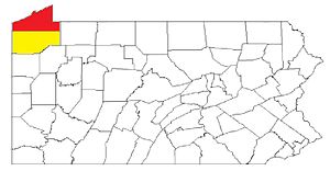
Warren County is a county in the Commonwealth of Pennsylvania. As of the 2020 census, the population was 38,587. Its county seat is Warren. The county was established in 1800 from parts of Allegheny and Lycoming counties; attached to Crawford County until 1805 and then to Venango County until Warren was formally established in 1819.

<span class="mw-page-title-main">Venango County, Pennsylvania</span> County in Pennsylvania, United States

Venango County is a county in the Commonwealth of Pennsylvania. As of the 2020 census, the population was 50,454. Its county seat is Franklin. The county was created in 1800 and later organized in 1805. The county is part of the Northwest Pennsylvania region of the state.

<span class="mw-page-title-main">Mercer County, Pennsylvania</span> County in Pennsylvania, United States

Mercer County is a county in the Commonwealth of Pennsylvania. As of the 2020 census, the population was 110,652. Its county seat is Mercer, and its largest city is Hermitage. The county is part of the Northwest Pennsylvania region of the state.

<span class="mw-page-title-main">Erie County, Pennsylvania</span> County in Pennsylvania, United States

Erie County is a county in the Commonwealth of Pennsylvania. It is the northernmost county in Pennsylvania. As of the 2020 census, the population was 270,876. Its county seat is Erie. The county was created in 1800 and later organized in 1803. The county is part of the Northwest Pennsylvania region of the state.

<span class="mw-page-title-main">Beaver Township, Crawford County, Pennsylvania</span> Township in Pennsylvania, United States

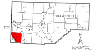
Beaver Township is a township in Crawford County, Pennsylvania, United States. The population was 795 at the 2020 census.

<span class="mw-page-title-main">Conneaut Township, Crawford County, Pennsylvania</span> Township in Pennsylvania, United States

Conneaut Township is a township in Crawford County, Pennsylvania, United States. The population was 1,334 at the 2020 census.

<span class="mw-page-title-main">Conneaut Lake, Pennsylvania</span> Borough in Pennsylvania, United States

Conneaut Lake is a borough in Crawford County, Pennsylvania, located at the southern end of the lake of the same name. The population was 625 at the 2020 census, down from 653 at the 2010 census.

<span class="mw-page-title-main">East Fallowfield Township, Crawford County, Pennsylvania</span> Township in Pennsylvania, United States

East Fallowfield Township is a township in Crawford County, Pennsylvania, United States. The population was 1,516 at the 2020 census, down from 1,620 in 2010.

<span class="mw-page-title-main">Linesville, Pennsylvania</span> Borough in Pennsylvania, United States

Linesville is a borough in Crawford County, Pennsylvania, United States. The population was 961 at the 2020 census, down from 987 at the 2019 census. The town derives its name from its founders, who included William Line, who migrated from Carlisle, Pennsylvania, circa the early 1820s, and his relative, Amos Line, who was the town's surveyor and main proprietor. Amos Line "penetrated the western Pennsylvania wilderness as a member of the Pennsylvania Population Company in the early 1800s."

<span class="mw-page-title-main">Meadville, Pennsylvania</span> City in Pennsylvania, United States

Meadville is a city in and the county seat of Crawford County, Pennsylvania, United States. The population was 13,050 at the 2020 census. The first permanent settlement in Northwestern Pennsylvania, Meadville is within 40 miles (64 km) of Erie and within 90 miles (140 km) of Pittsburgh. It is the principal city of the Meadville micropolitan area, as well as part of the larger Erie–Meadville combined statistical area.

<span class="mw-page-title-main">North Shenango Township, Pennsylvania</span> Township in Pennsylvania, United States

North Shenango Township is a township in Crawford County, Pennsylvania, United States. The population was 1,274 at the 2020 census, down from 1,410 at the 2010 census.

<span class="mw-page-title-main">South Shenango Township, Pennsylvania</span> Township in Pennsylvania, United States

South Shenango Township is a township in Crawford County, Pennsylvania, United States. The population was 1,831 at the 2020 census, down from 2,037 at the 2010 census.

<span class="mw-page-title-main">Venango Township, Crawford County, Pennsylvania</span> Township in Pennsylvania, United States

Venango Township is a township in Crawford County, Pennsylvania, United States. The population was 941 at the 2020 census, down from 997 at the 2010 census.

<span class="mw-page-title-main">Vernon Township, Pennsylvania</span> Township in Pennsylvania, United States

Vernon Township is a township in Crawford County, Pennsylvania, United States. The population was 5,310 at the 2020 census, down from 5,630 at the 2010 census.

<span class="mw-page-title-main">West Fallowfield Township, Crawford County, Pennsylvania</span> Township in Pennsylvania, United States

West Fallowfield Township is a township in Crawford County, Pennsylvania, United States. The population was 577 at the 2020 census, down from 605 at the 2010 census.

<span class="mw-page-title-main">West Shenango Township, Pennsylvania</span> Township in Pennsylvania, United States

West Shenango Township is a township in Crawford County, Pennsylvania, United States. The population was 435 at the 2020 census, down from 504 at the 2010 census.

<span class="mw-page-title-main">Beaver and Erie Canal</span>

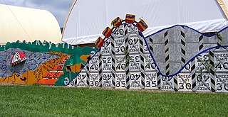
The Beaver and Erie Canal, also known as the Erie Extension Canal, was part of the Pennsylvania Canal system and consisted of three sections: the Beaver Division, the Shenango Division, and the Conneaut Division. The canal ran 136 miles (219 km) north–south near the western edge of the state from the Ohio River to Lake Erie through Beaver County, Lawrence County, Mercer County, Crawford County, and Erie County, Pennsylvania.

<span class="mw-page-title-main">Pennsylvania House of Representatives, District 6</span> American legislative district

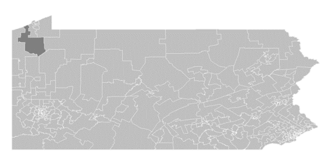
The 6th Pennsylvania House of Representatives District is located in northwestern Pennsylvania and has been represented since 2007 by Bradley T. Roae.

<span class="mw-page-title-main">Conneaut School District</span> School district in Pennsylvania

The Conneaut School District is a public school district in Crawford County, Pennsylvania and geographically encompasses approximately the western third of the county. The school district is approximately 8 miles west of Meadville, 40 miles (64 km) south of Erie and 91 miles (146 km) north of Pittsburgh. Comprising a total area of approximately 381 square miles (990 km2), the school district is bordered on the south by Mercer County, on the west by the state of Ohio, on the north by Erie County and on the east by the city of Meadville. The school district comprises the Boroughs of Conneaut Lake, Conneautville, Linesville and Springboro; and the Townships of Beaver, Conneaut, East Fallowfield, Greenwood, North Shenango, Pine, Sadsbury, Spring, Summerhill, Summit and West Fallowfield. The school district can be classified as rural with the majority of the work force employed in area contiguous to that of the school district.

<span class="mw-page-title-main">Erie–Meadville combined statistical area</span> Place in Pennsylvania, United States

The Erie–Meadville, PA Combined Statistical Area (CSA) is made up of two counties in northwestern Pennsylvania. The United States Office of Management and Budget has recognized the Erie and Meadville areas along with the counties of Erie and Crawford to make a Combined Statistical Area, located in northwestern Pennsylvania. Though these county line boundaries are rather arbitrary since Erie serves as the regional hub for the bordering areas of southwestern New York and northeastern Ohio, including the cities of Jamestown and Conneaut.

References

  1. Includes Erie, Mercer, Crawford and Venango Counties
  1. "PHMC Historical Markers Search". Pennsylvania Historical and Museum Commission. Commonwealth of Pennsylvania. Archived from the original (Searchable database) on November 13, 2013. Retrieved January 25, 2014.
  2. "Census - Geography Profile: Crawford County, Pennsylvania". United States Census Bureau . Retrieved June 26, 2022.
  3. "Find a County". National Association of Counties. Archived from the original on May 31, 2011. Retrieved June 7, 2011.
  4. Gannett, Henry (1905). The Origin of Certain Place Names in the United States. Govt. Print. Off. pp.  95.
  5. "2010 Census Gazetteer Files". United States Census Bureau. August 22, 2012. Retrieved March 6, 2015.
  6. "PRISM Climate Group at Oregon State University".
  7. "Census 2020".
  8. "U.S. Census website". United States Census Bureau . Retrieved January 31, 2008.
  9. "P2 HISPANIC OR LATINO, AND NOT HISPANIC OR LATINO BY RACE – 2020: DEC Redistricting Data (PL 94-171) – Crawford County, Pennsylvania".
  10. "Office of Management and Budget". whitehouse.gov.
  11. 1 2 "2010 U.S. Census website". United States Census Bureau . Retrieved December 29, 2015.
  12. Leip, David. "Dave Leip's Atlas of U.S. Presidential Elections". uselectionatlas.org.
  13. Pennsylvania Department of State (February 6, 2024). "Voter registration statistics by county". dos.pa.gov. Retrieved February 6, 2024.
  14. "Precision Manufacturing Institute (PMI)" . Retrieved April 7, 2007.
  15. "Member Biography: Robert F. Kent". Pennsylvania House of Representatives Archives. Retrieved October 30, 2022.

41°41′N80°07′W / 41.68°N 80.11°W / 41.68; -80.11