East Mead Township, Crawford County, Pennsylvania

Last updated
East Mead Township,
Crawford County, Pennsylvania
Frenchtown, Pennsylvania (8481196641).jpg
St. Hippolyte Church in Frenchtown
Map of East Mead Township, Crawford County, Pennsylvania Highlighted.png
Location of East Mead Township in Crawford County
Map of Pennsylvania highlighting Crawford County.svg
Location of Crawford County in Pennsylvania
CountryUnited States
State Pennsylvania
County Crawford County
Area
[1]
  Total23.43 sq mi (60.69 km2)
  Land22.85 sq mi (59.19 km2)
  Water0.58 sq mi (1.50 km2)
Highest elevation
[2] (high point west of Wayland on PA 27)
1,610 ft (490 m)
Lowest elevation
[2] (Little Sugar Creek)
1,180 ft (360 m)
Population
 (2020)
  Total1,321
  Estimate 
(2022) [3]
1,300
  Density62.96/sq mi (24.31/km2)
Time zone UTC-4 (EST)
  Summer (DST) UTC-5 (EDT)
Area code 814

East Mead Township is a township in Crawford County, Pennsylvania, United States. The population was 1,321 at the 2020 census, [3] down from 1,493 in the 2010 census. [4]

Contents

Geography

The township is located just south of the center of Crawford County and contains the unincorporated communities of Wayland (in the west) and Frenchtown (in the east). Tamarack Lake crosses the southwestern corner of the township.

According to the United States Census Bureau, the township has a total area of 23.3 square miles (60.3 km2), of which 22.9 square miles (59.2 km2) is land and 0.42 square miles (1.1 km2), or 1.85%, is water. [4]

Natural features

Geologic Province: [5] Northwestern Glaciated Plateau
Lowest Elevation: [6] 1,180 ft (360 m) Little Sugar Creek, where it flows southward out of the township.
Highest Elevation: [6] 1,610 ft (490 m) at a high point west of Wayland on PA 27.
Major Rivers/Streams and Watersheds: [6] Little Sugar Creek (most of township) and Woodcock Creek
Minor Rivers/Streams and Watersheds: [6]

Lakes and Waterbodies: [6] Tamarack Lake and Yosets Lake (both impoundments)
Biological Diversity Areas: [7] Little Sugar Creek at Blooming Valley BDA, Little Sugar Creek at Pettis Corner BDA, Yoset Lake Palustrine Forest BDA

Demographics

Historical population
CensusPop.Note
2000 1,485
2010 1,4930.5%
2020 1,321−11.5%
2022 (est.)1,300 [3] −1.6%
U.S. Decennial Census [8]

As of the census [9] of 2000, there were 1,485 people, 558 households, and 414 families residing in the township. The population density was 65.0 inhabitants per square mile (25.1/km2). There were 608 housing units at an average density of 26.6 per square mile (10.3/km2). The racial makeup of the township was 98.72% White, 0.07% African American, 0.13% Native American, 0.07% Asian, and 1.01% from two or more races. Hispanic or Latino of any race were 0.67% of the population.

There were 558 households, out of which 33.3% had children under the age of 18 living with them, 62.7% were married couples living together, 7.5% had a female householder with no husband present, and 25.8% were non-families. 21.1% of all households were made up of individuals, and 6.6% had someone living alone who was 65 years of age or older. The average household size was 2.66 and the average family size was 3.08.

In the township the population was spread out, with 26.7% under the age of 18, 8.2% from 18 to 24, 28.3% from 25 to 44, 25.0% from 45 to 64, and 11.9% who were 65 years of age or older. The median age was 37 years. For every 100 females there were 104.8 males. For every 100 females age 18 and over, there were 104.3 males.

The median income for a household in the township was $38,839, and the median income for a family was $43,438. Males had a median income of $31,293 versus $21,573 for females. The per capita income for the township was $18,138. About 7.3% of families and 8.1% of the population were below the poverty line, including 11.8% of those under age 18 and 6.5% of those age 65 or over.

Related Research Articles

<span class="mw-page-title-main">Dean Township, Cambria County, Pennsylvania</span> Township in Pennsylvania, United States

Dean Township is a township in Cambria County, Pennsylvania, United States. The population was 391 at the 2010 census. It is part of the Johnstown, Pennsylvania Metropolitan Statistical Area.

<span class="mw-page-title-main">Athens Township, Crawford County, Pennsylvania</span> Township in Pennsylvania, United States

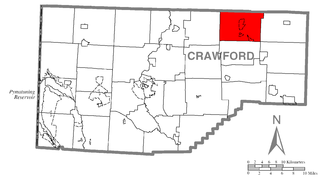
Athens Township is a township in Crawford County, Pennsylvania, United States. The population was 638 at the 2020 census.

<span class="mw-page-title-main">Beaver Township, Crawford County, Pennsylvania</span> Township in Pennsylvania, United States

Beaver Township is a township in Crawford County, Pennsylvania, United States. The population was 795 at the 2020 census.

<span class="mw-page-title-main">Bloomfield Township, Crawford County, Pennsylvania</span> Township in Pennsylvania, United States

Bloomfield Township is a township in Crawford County, Pennsylvania, United States. The population was 1,867 at the 2020 census.

<span class="mw-page-title-main">Blooming Valley, Pennsylvania</span> Borough in Pennsylvania, United States

Blooming Valley is a borough in Crawford County, Pennsylvania, United States. The population was 342 at the 2020 census, up from 337 at the 2010 census.

<span class="mw-page-title-main">Cambridge Township, Crawford County, Pennsylvania</span> Township in Pennsylvania, United States

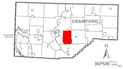
Cambridge Township is a township in Crawford County, Pennsylvania, United States. The population was 1,447 at the 2020 census.

<span class="mw-page-title-main">Conneaut Township, Crawford County, Pennsylvania</span> Township in Pennsylvania, United States

Conneaut Township is a township in Crawford County, Pennsylvania, United States. The population was 1,334 at the 2020 census.

<span class="mw-page-title-main">Cussewago Township, Crawford County, Pennsylvania</span> Township in Pennsylvania, United States

Cussewago Township is a township in Crawford County, Pennsylvania, United States. The population was 1,430 at the 2020 census.

<span class="mw-page-title-main">East Fairfield Township, Crawford County, Pennsylvania</span> Township in Pennsylvania, United States

East Fairfield Township is a township in Crawford County, Pennsylvania, United States. It was formed from Fairfield Township in 1869. The population was 837 at the 2020 census.

<span class="mw-page-title-main">East Fallowfield Township, Crawford County, Pennsylvania</span> Township in Pennsylvania, United States

East Fallowfield Township is a township in Crawford County, Pennsylvania, United States. The population was 1,516 at the 2020 census, down from 1,620 in 2010.

<span class="mw-page-title-main">Fairfield Township, Crawford County, Pennsylvania</span> Township in Pennsylvania, United States

Fairfield Township is a township in Crawford County, Pennsylvania, United States. The population was 1,011 at the 2020 census, down from the 2010 census.

<span class="mw-page-title-main">Greenwood Township, Crawford County, Pennsylvania</span> Township in Pennsylvania, United States

Greenwood Township is a township in Crawford County, Pennsylvania, United States. The population was 1,424 at the 2020 census, down from 1,454 at the 2010 census.

<span class="mw-page-title-main">Hayfield Township, Crawford County, Pennsylvania</span> Township in Pennsylvania, United States

Hayfield Township is a township in Crawford County, Pennsylvania, United States. The population was 2,776 at the 2020 census, down from 2,940 at the 2010 census.

<span class="mw-page-title-main">North Shenango Township, Pennsylvania</span> Township in Pennsylvania, United States

North Shenango Township is a township in Crawford County, Pennsylvania, United States. The population was 1,274 at the 2020 census, down from 1,410 at the 2010 census.

<span class="mw-page-title-main">Randolph Township, Pennsylvania</span> Township in Pennsylvania, United States

Randolph Township is a township in Crawford County, Pennsylvania, United States. The population was 1,718 at the 2020 census, down from 1,782 at the 2010 census.

<span class="mw-page-title-main">Sparta Township, Pennsylvania</span> Township in Pennsylvania, United States

Sparta Township is a township in Crawford County, Pennsylvania, United States. The population was 1,910 at the 2020 census, up from 1,832 at the 2010 census.

<span class="mw-page-title-main">Steuben Township, Pennsylvania</span> Township in Pennsylvania, United States

Steuben Township is a township in Crawford County, Pennsylvania, United States. The population was 773 at the 2020 census, down from 804 at the 2010 census, down from 908 in 2000.

<span class="mw-page-title-main">Summerhill Township, Crawford County, Pennsylvania</span> Township in Pennsylvania, United States

Summerhill Township is a township in Crawford County, Pennsylvania, United States. The population was 1,197 at the 2020 census, down from 1,236 at the 2010 census.

<span class="mw-page-title-main">West Mead Township, Pennsylvania</span> Township in Pennsylvania, United States

West Mead Township is a township in Crawford County, Pennsylvania, United States. The population was 5,040 at the 2020 census, down from 5,249 at the 2010 census.

<span class="mw-page-title-main">Woodcock Township, Pennsylvania</span> Township in Pennsylvania, United States

Woodcock Township is a township in Crawford County, Pennsylvania, United States. The population was 2,756 at the 2020 census, down from 2,856 at the 2010 census.

References

  1. "2016 U.S. Gazetteer Files". United States Census Bureau. Retrieved Aug 13, 2017.
  2. 1 2 "Cemetery Run Topo Map, Crawford County PA (Meadville Area)". TopoZone. Locality, LLC. Retrieved 2 September 2019.
  3. 1 2 3 Bureau, US Census. "City and Town Population Totals: 2020-2022". Census.gov. US Census Bureau. Retrieved August 24, 2023.
  4. 1 2 "Geographic Identifiers: 2010 Census Summary File 1 (G001): East Mead township, Crawford County, Pennsylvania". U.S. Census Bureau, American Factfinder. Archived from the original on February 13, 2020. Retrieved June 5, 2015.
  5. "Physiographic Provinces of Pennsylvania". Map of the Physiographic Provinces of Pennsylvania. PA DCNR. Retrieved 25 June 2022.
  6. 1 2 3 4 5 "Get Maps". USGS Topoview. US Geological Survey. Retrieved 15 May 2021.
  7. "Crawford County Natural Heritage Inventory" (PDF). Pennsylvania Natural Heritage Inventory. PNHI. Retrieved 15 May 2021.
  8. "Census of Population and Housing". Census.gov. Retrieved June 4, 2016.
  9. "U.S. Census website". United States Census Bureau . Retrieved 2008-01-31.

41°38′00″N80°02′59″W / 41.63333°N 80.04972°W / 41.63333; -80.04972