Avra Valley is a census-designated place (CDP) in Pima County, Arizona, United States. The population was 6,050 at the 2010 census, up from 5,038 in 2000.
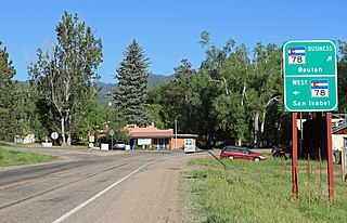
Beulah Valley is a census-designated place (CDP) in and governed by Pueblo County, Colorado, United States. The CDP is a part of the Pueblo, CO Metropolitan Statistical Area. The population of the Beulah Valley CDP was 518 at the United States Census 2020. The Beulah post office (Zip Code 81023) serves the area.
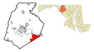
Green Valley is an unincorporated area and census-designated place (CDP) in southern Frederick County, Maryland, United States. The population was 12,643 at the 2020 census. The area was listed as a census-designated place in 2000 but not listed as part of any CDP at the 2010 census. It was re-designated a census-designated place for the 2020 census.

Devon is a census-designated place (CDP) located in Easttown township in Chester County, Pennsylvania, United States. The population was 1,515 at the 2010 census. The area is part of the Philadelphia Main Line suburbs.

The Blacksburg-Christiansburg Metropolitan Statistical Area, formerly the Blacksburg-Christiansburg-Radford Metropolitan Statistical Area, is a Metropolitan Statistical Area (MSA) as defined by the United States Office of Management and Budget (OMB) located in the New River Valley of Southwest Virginia. As of the 2020 census, the MSA had a population of 181,863.

The Roanoke Metropolitan Statistical Area is a Metropolitan Statistical Area (MSA) in Virginia as defined by the United States Office of Management and Budget (OMB). The Roanoke MSA is sometimes referred to as the Roanoke Valley, even though the Roanoke MSA occupies a larger area than the Roanoke Valley. It is geographically similar to the area known as the Roanoke Region of Virginia, but while the latter includes Alleghany County, the former does not. As of the 2020 census, the MSA had a population of 315,251.
Gann Valley is a census-designated place in and the county seat of Buffalo County, South Dakota, United States. The town had a population of 10 as of the 2020 census. It is the smallest unincorporated county seat in the United States.

Shippensburg University of Pennsylvania is a public university that is located in Shippensburg, Pennsylvania. It is part of the Pennsylvania State System of Higher Education.

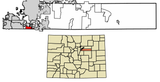
Coaldale is a census-designated place (CDP) and post office located in and governed by Fremont County, Colorado, United States. The CDP is a part of the Cañon City, CO Micropolitan Statistical Area. The Coaldale post office has the ZIP Code 81222. At the United States Census 2020, the population of the Coaldale CDP was 343.

Wilcox is a census-designated place located in Jones Township, Elk County, Pennsylvania, United States. The community was named after a settler, Col. A.I. Wilcox. As of the 2020 census, Wilcox had a population of 354.

Gibraltar is a census-designated place (CDP) in northern Robeson Township in southern Berks County, Pennsylvania, United States. Its population was 680 as of the 2010 census. The community is four miles from Birdsboro and 6.4 miles from downtown Reading. It is served by the Twin Valley School District and is across the Schuylkill River from Exeter.
Green Valley is an unincorporated census-designated place located in the town of Green Valley, Shawano County, Wisconsin, United States. Green Valley is 16.5 miles (26.6 km) east of Shawano. As of the 2010 census, its population was 133.
Dove Valley is an unincorporated community and a census-designated place (CDP) located in and governed by Arapahoe County, Colorado, United States. The CDP is a part of the Denver–Aurora–Lakewood, CO Metropolitan Statistical Area. The population of the Dove Valley CDP was 5,640 at the United States Census 2020. The Dove Valley Metropolitan District provides services to the area, which lies in ZIP code 80112.
Valley Bend is a census-designated place (CDP) in Randolph County, West Virginia, United States. Valley Bend is located on U.S. routes 219 and 250, as well as state routes 55 and 92, 3.5 miles (5.6 km) northwest of Mill Creek. Valley Bend has a post office with ZIP code 26293. As of the 2010 census, its population was 485.

Beaver Valley is a census-designated place in Gila County in the state of Arizona. Beaver Valley is located about 10 miles north of the town of Payson. The population, as of the 2010 U.S. Census, was 231.
Trout Valley is a census-designated place in Grant County, New Mexico, United States. Its population was 16 as of the 2010 census. New Mexico State Road 35 passes through the community.
Peak Place is an unincorporated community and census-designated place in Santa Fe County, New Mexico, United States. Its population was 377 as of the 2010 census.
Wautec is an unincorporated community and census-designated place (CDP) in Humboldt County, California, United States. It is located within the Yurok Indian Reservation, in the valley of the Klamath River 20 miles (32 km) northeast (downstream) of Weitchpec. It was first listed as a CDP prior to the 2020 census.
Eastern Goleta Valley is a census-designated place (CDP) in Santa Barbara County, California, United States. It is located between Goleta to the west, Santa Barbara to the east, the Pacific Ocean to the south, and the Santa Ynez Mountains to the north. It was first listed as a CDP prior to the 2020 census.

Lower Berkshire Valley is a census-designated place (CDP) located in Roxbury and Jefferson townships, Morris County, in the U.S. state of New Jersey. It is primarily in the northeast part of Roxbury, along Berkshire Valley Road. Interstate 80 passes through the southern part of the CDP, but with no direct access. The community is 2 miles (3 km) northwest of Wharton and 4 miles (6 km) northwest of Dover.