Union Dale, Pennsylvania

Last updated
Union Dale, Pennsylvania
Susquehanna County Pennsylvania Incorporated and Unincorporated areas Union Dale Highlighted.svg
Location of Union Dale in Susquehanna County, Pennsylvania.
USA Pennsylvania location map.svg
Red pog.svg
Union Dale
Usa edcp location map.svg
Red pog.svg
Union Dale
Coordinates: 41°42′58″N75°29′13″W / 41.71611°N 75.48694°W / 41.71611; -75.48694 Coordinates: 41°42′58″N75°29′13″W / 41.71611°N 75.48694°W / 41.71611; -75.48694
Country United States
State Pennsylvania
County Susquehanna
Incorporated1885
Area
[1]
  Total2.47 sq mi (6.39 km2)
  Land2.41 sq mi (6.23 km2)
  Water0.06 sq mi (0.16 km2)
Population
 (2020) [2]
  Total222 Decrease2.svg
  Estimate 
(2021) [2]
223
  Density99.33/sq mi (38.35/km2)
Time zone UTC-5 (Eastern (EST))
  Summer (DST) UTC-4 (EDT)
ZIP code
18470
Area code 570
FIPS code 42-78456

Union Dale is a borough in Susquehanna County, Pennsylvania, United States. The borough was incorporated in 1885. [3] Union Dale's population was 267 at the 2010 census.

Contents

Geography

Union Dale is located at 41°42′58″N75°29′13″W / 41.71611°N 75.48694°W / 41.71611; -75.48694 (41.715974, -75.486995). [4]

According to the United States Census Bureau, the borough has a total area of 2.5 square miles (6.5 km2), of which 2.4 square miles (6.2 km2) is land and 0.1 square miles (0.26 km2) (2.4%) is water.

Just outside Union Dale is the North Knob of Elk Mountain. It is the highest point in Eastern Pennsylvania, as well as in the Allegheny Plateau.

Demographics

Historical population
CensusPop.
1880 146
1890 360146.6%
1900 351−2.5%
1910 3551.1%
1920 3704.2%
1930 331−10.5%
1940 3485.1%
1950 3500.6%
1960 287−18.0%
1970 279−2.8%
1980 32115.1%
1990 303−5.6%
2000 36821.5%
2010 267−27.4%
2020 222−16.9%
2021 (est.)223 [2] 0.5%
Sources: [5] [6] [7]

As of the census [8] of 2010, there were 267 people, 130 households, and 73 families residing in the borough. The population density was 111.2 people per square mile (43.4/km2). There were 157 housing units at an average density of 65.4 per square mile (25.5/km2). The racial makeup of the borough was 98.5% White, 1.1% African American, and 0.4% from two or more races. Hispanic or Latino of any race were 1.5% of the population.

There were 130 households, out of which 15.4% had children under the age of 18 living with them, 45.4% were married couples living together, 7.7% had a female householder with no husband present, and 43.8% were non-families. 40.8% of all households were made up of individuals, and 15.3% had someone living alone who was 65 years of age or older. The average household size was 2.05 and the average family size was 2.70.

In the borough the population was spread out, with 16.5% under the age of 18, 64% from 18 to 64, and 19.5% who were 65 years of age or older. The median age was 48 years.

The median income for a household in the borough was $39,375, and the median income for a family was $44,375. Males had a median income of $40,556 versus $32,857 for females. The per capita income for the borough was $20,908. About 6.5% of families and 12.5% of the population were below the poverty line, including 28.3% of those under age 18 and 22.9% of those age 65 or over.

Education

Forest City Regional School District is a Preschool-12th grade public school district serving residents of Union Dale.

See also

Related Research Articles

<span class="mw-page-title-main">Driftwood, Pennsylvania</span> Borough in Pennsylvania, United States

Driftwood is a borough in Cameron County, Pennsylvania, United States. The population was 36 at the 2020 census.

<span class="mw-page-title-main">Vandling, Pennsylvania</span> Borough in Pennsylvania, United States

Vandling is a borough in the northeastern corner of Lackawanna County, Pennsylvania, United States. The population was 730 at the 2020 census. It is located immediately south of Forest City, which is in Susquehanna County.

<span class="mw-page-title-main">Edwardsville, Pennsylvania</span> Borough in Pennsylvania, United States

Edwardsville is a borough in Luzerne County, Pennsylvania, United States. The population was 4,918 at the 2020 census.

<span class="mw-page-title-main">Exeter Township, Luzerne County, Pennsylvania</span> Township in Pennsylvania, United States

Exeter Township is a township within the Greater Pittston area of Luzerne County, Pennsylvania, United States. The population was 2,047 at the 2020 census. Upper Exeter and Harding are two villages in the township.

<span class="mw-page-title-main">Larksville, Pennsylvania</span> Borough in Pennsylvania, United States

Larksville is a borough in Luzerne County, Pennsylvania, United States. It is 2 miles (3 km) west of Wilkes Barre on the Susquehanna River. The population was 4,216 as of the 2020 census.

<span class="mw-page-title-main">Sugar Notch, Pennsylvania</span> Borough in Pennsylvania, United States

Sugar Notch is a borough in Luzerne County, Pennsylvania, United States. The population was 996 at the 2020 census.

<span class="mw-page-title-main">West Pittston, Pennsylvania</span> Borough in Pennsylvania, United States

West Pittston is a borough in the Greater Pittston area of Luzerne County, Pennsylvania, United States. It is located on the Susquehanna River. In 2020, the population was 4,644.

<span class="mw-page-title-main">West Wyoming, Pennsylvania</span> Borough in Pennsylvania, United States

West Wyoming is a borough in Luzerne County, Pennsylvania, United States. The borough is located within the Greater Pittston metro area. The population was 2,631 at the 2020 census.

<span class="mw-page-title-main">Wyoming, Pennsylvania</span> Borough in Luzerne County, Pennsylvania, US

Wyoming is a borough in the Greater Pittston area of Luzerne County, Pennsylvania, United States. It is located 5 miles (8 km) north of Wilkes-Barre, along the Susquehanna River. The population was 3,097 as of the 2020 census.

<span class="mw-page-title-main">Ulysses Township, Potter County, Pennsylvania</span> Township in Pennsylvania, United States

Ulysses Township is a township in Potter County, Pennsylvania, United States. As of the 2020 census, the township population was 647. There are two Pennsylvania state parks in Ulysses Township. Denton Hill State Park is a ski resort along U.S. Route 6. Lyman Run State Park is in the southern part of the township and is partially in neighboring West Branch Township. Its population includes extreme white supremacy groups, and has done so for about 100 years.

<span class="mw-page-title-main">Great Bend, Pennsylvania</span> Borough in Pennsylvania, United States

Great Bend is a borough in Susquehanna County, Pennsylvania, United States, 39 miles (63 km) north of Scranton. According to 2020 Census data, Great Bend's population was 634, down 13.6% from 2010. Great Bend sits along the Susquehanna River, less than two miles from the New York State border, and is located directly off Interstate 81. Several small manufacturers also call Great Bend home. Great Bend is considered a bedroom community of the Binghamton, NY metropolitan area. Downtown Binghamton is roughly 11 miles (18 km) from Great Bend. The borough has three public parks. Billy Greenwood Memorial Park on Kilrow Avenue and Veterans' Memorial Park on Spring St. overlook the Susquehanna River. Great Bend is within the Blue Ridge School District.

<span class="mw-page-title-main">Hallstead, Pennsylvania</span> Borough in Pennsylvania, United States

Hallstead is a borough in Susquehanna County, Pennsylvania. The population was 1,179 at the 2020 census.

<span class="mw-page-title-main">Hop Bottom, Pennsylvania</span> Borough in Pennsylvania, United States

Hop Bottom is a borough of Susquehanna County, Pennsylvania, United States. The population was 310 as of the 2020 census. The name comes from the hop, a plant providing flowers for brewing.

<span class="mw-page-title-main">Lanesboro, Pennsylvania</span> Borough in Pennsylvania, United States

Lanesboro is a borough in Susquehanna County, Pennsylvania, United States. The population was 485 at the 2020 census.

<span class="mw-page-title-main">Little Meadows, Pennsylvania</span> Borough in Pennsylvania, United States

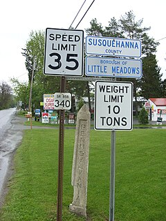
Little Meadows is a borough in Susquehanna County, Pennsylvania, United States. The population was 247 at the 2020 census.

<span class="mw-page-title-main">Montrose, Pennsylvania</span> Borough in Pennsylvania, United States

Montrose is a borough in Susquehanna County, Pennsylvania, United States, 18.41 miles (29.63 km) south-southeast of Binghamton, New York and 31.39 miles (50.52 km) north by west of Scranton. The land is elevated approximately 1,400 feet above sea level. It is the Susquehanna County seat.

<span class="mw-page-title-main">New Milford, Pennsylvania</span> Borough in Pennsylvania, United States

New Milford is a borough in Susquehanna County, Pennsylvania, United States. The population was 817 at the 2020 census. Children living in New Milford are served by the schools in the Blue Ridge School District, including Blue Ridge High School.

<span class="mw-page-title-main">Oakland, Susquehanna County, Pennsylvania</span> Borough in Pennsylvania, United States

Oakland is a borough in Susquehanna County, Pennsylvania, United States. The population of Oakland borough was 564 at the 2020 census.

<span class="mw-page-title-main">Susquehanna Depot, Pennsylvania</span> Borough in Pennsylvania, United States

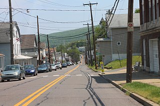
Susquehanna Depot, often referred to simply as Susquehanna, is a borough in Susquehanna County, Pennsylvania, United States, located on the Susquehanna River 23 miles (37 km) southeast of Binghamton, New York. In the past, railroad locomotives and railroad cars were made here. It is also known for its Pennsylvania Bluestone quarries.

<span class="mw-page-title-main">Thompson, Pennsylvania</span> Borough in Pennsylvania, United States

Thompson is a borough in Susquehanna County, Pennsylvania, United States. The population was 255 at the 2020 census.

References

  1. "2019 U.S. Gazetteer Files". United States Census Bureau. Retrieved July 28, 2020.
  2. 1 2 3 Bureau, US Census. "City and Town Population Totals: 2020—2021". Census.gov. US Census Bureau. Retrieved August 5, 2022.
  3. "Herrick Township". Susquehanna County Historical Society. Archived from the original on 13 January 2015. Retrieved 15 December 2019.
  4. "US Gazetteer files: 2010, 2000, and 1990". United States Census Bureau. 2011-02-12. Retrieved 2011-04-23.
  5. "Census of Population and Housing". U.S. Census Bureau. Retrieved 11 December 2013.
  6. "U.S. Census website". United States Census Bureau . Retrieved 2008-01-31.
  7. "Incorporated Places and Minor Civil Divisions Datasets: Subcounty Resident Population Estimates: April 1, 2010 to July 1, 2012". Population Estimates. U.S. Census Bureau. Archived from the original on 11 June 2013. Retrieved 11 December 2013.
  8. "U.S. Census website". United States Census Bureau . Retrieved 2011-05-14.