
Pleasant Valley School District is a mid-sized, rural, public school district in the west end of Monroe County, Pennsylvania in the United States. The district encompasses approximately 114 square miles (300 km2) including: Chestnuthill, Eldred, Polk, and Ross Townships, as well as communities in them, such as Brodheadsville. As of 2000, the school district served a resident population of 29,051.

Solanco School District is a large, rural public school district located in the southern end of Lancaster County, Pennsylvania. Solanco School District encompasses approximately 180 square miles (470 km2). Solanco School District serves: Providence Township, Eden Township, Quarryville Borough, Little Britain Township, Bart Township, Colerain Township, Drumore Township, East Drumore Township and Fulton Township. According to 2008 local census data, it served a resident population of 30,566. By 2010, the district's population increased to 31,871 people. In 2009, the district residents’ per capita income was $17,040, while the median family income was $49,432. In the Commonwealth, the median family income was $49,501 and the United States median family income was $49,445, in 2010.
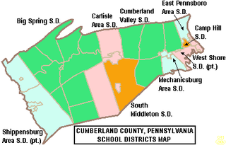
The Cumberland Valley School District is a large, rural and suburban public school district located in Central Pennsylvania. It covers Hampden Township, Monroe Township, Middlesex Township and Silver Spring Township in Cumberland County, Pennsylvania. According to 2000 federal census data, it served a resident population of 46,926. By 2010, the district's population increased to 54,670 people. In 2009, the district residents’ per capita income was $28,440, while the median family income was $66,515. In the Commonwealth, the median family income was $49,501 and the United States median family income was $49,445, in 2010. By 2013, the median household income in the United States rose to $52,100.

Hampton Township School District is a midsize, urban/suburban public school district operating in Allegheny County, Pennsylvania. The district serves only the residents of Hampton Township, Western Pennsylvania, USA. The district encompasses approximately 16 square miles (41 km2). According to 2000 federal census data, Hampton Township School District served a resident population of 17,526 people. Per the US Census Bureau in 2010, the population rose to 18,367 people. The district graduated its first class in 1943.

Tunkhannock Area School District is a midsized rural/suburban public school district serving most of Wyoming County in northeast Pennsylvania in the United States. Tunkhannock Area School District encompasses approximately 397 square miles (1,030 km2). According to 2010 federal census data, Tunkhannock Area School District served a resident population of 28,276. By 2010, the district's population declined sharply to 19,032 people. In 2009, the district residents’ per capita income was $18,112, while the median family income was $44,626. In the Commonwealth, the median family income was $49,501 and the United States median family income was $49,445, in 2010.

West Branch Area School District is a mid-sized, rural, public school district located in Morrisdale, Clearfield County, and Clinton County, Pennsylvania. The district is one of the 500 public school districts of Pennsylvania. West Branch Area School District was created in 1958 by the joining of Cooper Township High School and Morris Township High School. The district also includes Karthaus Township and Graham Township. The district extends across the Clearfield County's eastern border to include West Keating Township in Clinton County. West Branch Area School District encompasses approximately 165 square miles (430 km2). According to 2000 federal census data, it served a resident population of 7,833. By 2010, the district's population was 7,857 people. The educational attainment levels for the school district population were 85% high school graduates and 9.3% college graduates. In 2009, West Branch Area School District residents' per capita income was $15,055, while the median family income was $37,054 a year. In the Commonwealth, the median family income was $49,501 and the United States median family income was $49,445, in 2010.

The Bloomsburg Area School District is a small, suburban/rural public school district. The district is one of the 500 school districts of Pennsylvania. The Bloomsburg Area School District serves the Town of Bloomsburg and Beaver Township, Hemlock Township, Main Township and Montour Township in Columbia County, Pennsylvania. The district encompasses approximately 81 square miles (210 km2). According to 2000 federal census data, it served a resident population of 17,860. By 2010, the district's population increased to 20,654 people. The educational attainment levels for the district's population were 91.5% high school graduates and 26.4% college graduates.
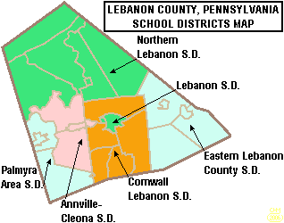
The Palmyra Area School District is the public school system in southwest Lebanon County, Pennsylvania.

Smethport Area School District is a rural, public school district located in McKean County, Pennsylvania, United States. Situated in the north central part of the state, it overlooks the borough of Smethport, which serves as the county seat.
Port Allegany School District is a small, rural, public school district located in McKean County and Potter County, Pennsylvania, United States. Geographically, the district is in the north-central-west part of the state. The district encompasses an area of about 169 square miles (440 km2). It includes Annin and Liberty Townships and Port Allegany in McKean County and Roulette and Pleasant Valley Townships in Potter County. According to 2000 federal census data, it serves a resident population of 6,344. In 2010, the district's population had decreased to 5,737 people. The offices for the school system are in Port Allegany High School, which is in the borough of Port Allegany.
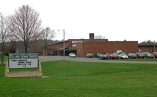
Elk Lake School District is a small, rural, K-12 public school district with its only building located on State Route 3019 in Dimock, Susquehanna County, Pennsylvania. It covers Auburn Township, Middletown Township, Rush Township, Dimock Township, and Springville Township in Susquehanna County, along with Meshoppen Borough and Meshoppen Township in Wyoming County. The Elk Lake School District encompasses approximately 197 square miles (510 km2). According to 2000 federal census data, Elk Lake School District serves a resident population of 7,735 people. In 2009, the district residents’ per capita income was $15,355, while the median family income was $38,385. In the Commonwealth, the median family income was $49,501 and the United States median family income was $49,445, in 2010. In 2006, the district students are 97% white, less than 1% Asian, less than 1% black and 2% Hispanic.

The Boyertown Area School District is a large public school district which covers portions of Berks and Montgomery Counties in southeastern Pennsylvania. When the Boyertown Area School District was formed in 1953 it was one of the largest in the state, encompassing 100 square miles (260 km2). In Berks County it covers the Boroughs of Bally, Bechtelsville and Boyertown and Colebrookdale Township, Douglass Township, Earl Township and Washington Township. In Montgomery County it covers Douglass Township, New Hanover Township and Upper Frederick Township.

The Brookville Area School District is a small, rural public school district which encompasses approximately 262 square miles (680 km2). The District serves the Boroughs of Brookville and Summerville and Barnett Township, Beaver Township, Clover Township, Eldred Township, Heath Township, Knox Township, Pine Creek Township, Rose Township and Warsaw Township in Jefferson County, Pennsylvania. According to 2000 federal census data, it serves a resident population of 12,485. In 2009, Brookville Area School District residents’ per capita income was $16,945, while the median family income was $38,465. In the Commonwealth, the median family income was $38,438 and the United States median family income was $49,445, in 2010.
The Carlisle Area School District is a midsized, suburban, public school district that serves the boroughs of Carlisle and Mount Holly Springs and Dickinson Township and North Middleton Township in Cumberland County, Pennsylvania. Carlisle Area School District encompasses approximately 75 square miles (190 km2). According to 2000 federal census data, it serves a resident population of 34,794. in 2009, the residents' per capita income was $22,214, while the districts' median family income was $52,276.

The Elwood City Area School District (ECASD) is a diminutive, suburban, public school district located in Beaver County, Pennsylvania and Lawrence County, Pennsylvania. It serves the boroughs of Ellwood City, Ellport, and New Beaver, and the townships of Wayne, and Perry Townships. Elwood City Area School District encompasses approximately 49 square miles (130 km2). According to 2000 federal census data, it served a resident population of 14,040. In 2010 the district's population risen to 14,341 people. In 2009, the district residents’ per capita income was $16,554, while the median family income was $42,326. In the Commonwealth, the median family income was $49,501 and the United States median family income was $49,445, in 2010.

Southern Tioga School District is a small, rural public school system located in northern Central Pennsylvania covering parts of Tioga County and Lycoming County. It encompasses 485 square miles (1,260 km2). According to 2010 federal census data, it serves a resident population of 15,551 making it a third class school district. The district operates schools in Mansfield, Liberty, and Blossburg. It serves residents in: Covington Township, Rutland Township, Richmond Township, Liberty Township, Bloss Township, Sullivan Township, Ward Township, Morris Township, and Hamilton Township, as well as Roseville Borough and Putnam. In Lycoming County, Southern Tioga School District serves both: Jackson Township and Cogan House Township.

The Reynolds School District is a rural, public school district serving parts of Mercer County, Pennsylvania. Reynolds School District encompasses approximately 88 square miles (230 km2) encompassing the communities of Fredonia, West Salem Township, Delaware Township, and Pymatuning Township. The western border of the district is part of the Pennsylvania - Ohio border. According to 2000 federal census data, it served a resident population of 10,158. By 2010, the district's population declined to 9,611 people. It is built on what was once a military camp during World War II, Camp Reynolds. In 2009, the district residents' per capita income was $16,380 while the median family income was $42,200. In the Commonwealth, the median family income was $49,501 and the United States median family income was $49,445, in 2010.
The Williams Valley School District is a small, rural public school district located in Dauphin County, Pennsylvania and Schuylkill County, Pennsylvania. The district is highly fragmented, encompassing the boroughs of Williamstown and Tower City as well as the townships of Porter, Rush, Williams, and Wiconisco. The district encompasses approximately 62 square miles (160 km2).

The Northern Potter School District is a rural public school district located in northeastern Potter County, Pennsylvania. It serves the municipalities of Ulysses, Ulysses Township, Genesee Township, Bingham Township, and Harrison Township. Portions of Allegany Township and Hector Township are also within its boundaries. Northern Potter School District encompasses approximately 231 square miles (600 km2). According to 2010 federal census data, it serves a resident population of 4,113, making it a district of the fourth class. The educational attainment levels for the School District population were 84% high school graduates and 8.2% college graduates. The district is one of the 500 public school districts of Pennsylvania.
The Galeton Area School District is a diminutive, rural public school district operating in Potter County, Pennsylvania. Galeton Area School District encompasses approximately 325 square miles (840 km2). It serves the municipalities of Galeton, Abbott Township, West Branch Township, Pike Township, and a portion of Hector Township in Potter County, plus Elk Township and Gaines Township in Tioga County, Pennsylvania. According to 2000 federal census data, the district served a resident population of 3,292. By 2010, the district's population declined to 2,929 people. The educational attainment levels for the Galeton Area School District population were 82.7% high school graduates and 9.6% college graduates.

