Sideling Hill

Last updated
Sideling Hill
2019-07-14 13 12 11 View west along Interstate 68 and U.S. Route 40 (National Freeway) from the Victor Cushwa Memorial Bridge as it passes through the Sideling Hill Road Cut in Forest Park, Washington County, Maryland.jpg
Interstate 68 road cut in Sideling Hill in Western Maryland
Highest point
Elevation 2,311 ft (704 m)
Prominence 280
Coordinates 40°00′32″N78°07′46″W / 40.0090°N 78.1295°W / 40.0090; -78.1295
at Fisher Point
Geography
Location West Virginia, Maryland, and Pennsylvania, U.S.
Parent range Ridge-and-Valley province, Appalachian Mountains
Topo map USGS Wells Tannery

Sideling Hill, also Side Long Hill, [1] is a long, steep, narrow mountain ridge in the Ridge-and-Valley (or Allegheny Mountains) physiographic province of the Appalachian Mountains, located in Washington County in western Maryland and adjacent West Virginia and Pennsylvania, USA. The highest point on the ridge is Fisher Point, at 2,310 feet (700 m) [2] in Fulton County, Pennsylvania. [1]

Contents

Geology

Oblique air photo of Sideling Hill, facing north, with the I-68 road cut near center, and the path of the National Road (Scenic US 40) visible to the south Sideling Hill airphoto.jpg
Oblique air photo of Sideling Hill, facing north, with the I-68 road cut near center, and the path of the National Road (Scenic US 40) visible to the south

Sideling Hill is a syncline mountain, in a region of downward-folded (synclinal) rock strata between two upfolded anticlines. The ridge is capped by an erosion-resistant conglomerate and sandstone of Mississippian (early Carboniferous) geologic age, the Purslane Sandstone of the Pocono Formation. The ridge's slopes are formed of much more easily eroded kinds of rock, including the Devonian-Mississippian Rockwell Formation, with long, narrow valleys paralleling the ridge on either side.

Ecology

Most of the crest of Sideling Hill is forested, primarily with various deciduous tree species such as oaks (Quercus) and hickories (Carya), along with occasional evergreen pines (Pinus).

Highway, railroad, and canal crossings

Only a few major highways, one active and two former railroads, and one former canal cross this steep mountain ridge.

East Broad Top Railroad Tunnel (Pennsylvania)

East Broad Top Railroad Tunnel at Sideling Hill, south portal EBT Sideling Hill Tunnel.jpg
East Broad Top Railroad Tunnel at Sideling Hill, south portal

The East Broad Top Railroad constructed a tunnel through Sideling Hill in 1873–1874 as part of its mainline construction. The tunnel predates the South Pennsylvania Railroad tunnel construction 11 miles (18 km) to the south by eight years. The tunnel is single-tracked, and curved at each end. It originally had a stone portal on its eastern (RR North) end and a natural stone portal at its western (RR South) end, but about 1919 the north portal was replaced with a concrete one.

The north portal was equipped with doors to prevent wind from blowing through the tunnel as the wind caused water percolating into the tunnel to freeze on the tracks in the winter. In 1911, this ice caused the brand new locomotive #12 to derail its pilot axle inside the tunnel then derail the entire locomotive at the Kimmel switch just beyond the tunnel. In the 1940s, the doors were equipped with remote actuators mounted on poles a few hundred feet before each portal. This allowed the crews to open and close the doors without stopping. The system did not work flawlessly and a door was ripped off by a caboose cupola.

The tunnel was in service from 1874 until the railroad ceased operations in 1956. The line is technically out of service (but not abandoned), and the track is still in place through the tunnel, although not serviceable. The tunnel and rail line are private property and not open to the public.

Pennsylvania Turnpike (I-76)

The Pennsylvania Turnpike (Interstate 76, I-76) crosses Sideling Hill east of Breezewood, Pennsylvania, bypassing the two-lane Sideling Hill Tunnel and the nearby Rays Hill Tunnel that were formerly used by the Turnpike. Completed at a cost of $17,203,000, the Sideling Hill bypass opened on November 26, 1968, and the former alignment through the tunnels became known as the Abandoned Pennsylvania Turnpike. A rest area next to the ridge was a stop on Bill Clinton and Al Gore's post-convention bus tour in 1992.

Sideling Hill Tunnel (Pennsylvania)

The western portal of the now-abandoned Sideling Hill Tunnel, along the former mainline of the Pennsylvania Turnpike Sideling Hill Tunnel, western portal.jpg
The western portal of the now-abandoned Sideling Hill Tunnel, along the former mainline of the Pennsylvania Turnpike

The Sideling Hill Tunnel, through Sideling Hill in Pennsylvania east of Breezewood, is currently in its third phase of life. In the 1880s, a tunnel was partially bored through the mountain by the South Pennsylvania Railroad. The railroad project ceased, and the tunnel was left abandoned. When construction of the Pennsylvania Turnpike was begun in the 1930s by the Pennsylvania Turnpike Commission on the right-of-way of the South Pennsylvania Railroad, the tunnel was completed for highway use by the turnpike.[ citation needed ]

The tunnel, the longest of the seven original turnpike tunnels at 6,782 feet (2,067 m) long, was used from the turnpike's opening in 1940 until 1968. Due to increasing traffic on the highway, the turnpike commission began upgrading all of its two-lane tunnels, constructing twin bores for its tunnels through the Allegheny, Tuscarora, Kittatinny, and Blue mountains, and bypassing the tunnels under Laurel Hill, Rays Hill, and Sideling Hill with new, six-lane highways climbing the adjacent hills. The Sideling Hill Tunnel and the nearby Rays Hill tunnel, along with connecting segments of four-lane highway, were used for many years as a testing facility for new highway technologies.[ citation needed ]

In 2001, the Sideling Hill Tunnel was sold to the Southern Alleghenies Conservancy for $1, which now operates it as a bike trail. [3]

Sideling Hill Road Cut (I-68 and US 40, Maryland)

The Sideling Hill cut from the rest stop pedestrian bridge Sideling Hill cut MD1.jpg
The Sideling Hill cut from the rest stop pedestrian bridge
The Sideling Hill Road Cut, as seen from I-70 Sidling-Hill-MD.jpg
The Sideling Hill Road Cut, as seen from I-70

The Sideling Hill Road Cut on I-68 and US 40 is a 340-foot-deep (100 m) notch excavated from the ridge of Sideling Hill, about five miles (8.0 km) west of Hancock in Washington County, Maryland. Blasting was completed in August 1984. [4] It is notable as an impressive man-made mountain pass, visible from miles away, and is considered to be one of the best rock exposures in Maryland and the entire northeastern United States. [5] Almost 810 feet (250 m) [5] of strata in a tightly folded syncline are exposed in this road cut. Although other exposures may surpass Sideling Hill in either thickness of exposed strata or in quality of geologic structure, few can equal its combination of both. [5] The exposed rocks consist of the Devonian-Mississippian Rockwell Formation, underlying the Mississippian Purslane Sandstone.

Rest stop and former exhibit center

A highway rest stop, located near the eastern side of the Sideling Hill Road Cut on I-68 west of Hancock, includes a pedestrian bridge crossing I-68, connecting the eastbound and westbound rest areas and offering views of the cut, in which stopping is prohibited.

The rest stop formerly included the Sideling Hill Exhibit Center, a four-level geological museum and travel information center which opened in 1991. Due to state budget cuts, this facility was closed on August 15, 2009, as part of a $280 million budget reduction package, saving the state about $110,000 annually. Before its closing, the center served about 95,000 visitors a year. [6] Many of the geological exhibits from the former Exhibit Center are now displayed at the Hancock Museum in nearby Hancock, Maryland. [5] [7]

The former exhibit center building was reopened as a welcome center on October 9, 2015. Only part of the facility is open, with the former exhibit center exhibits remaining at the Hancock Museum. [8]

National Road (US 40 Scenic)

Before construction of I-68, US 40 (now US 40 Scenic), the National Road, crossed Sideling Hill with a steep grade on each side and a sharp hairpin turn at the crest of the mountain.

Potomac River Water Gap

The water gap cut through Sideling Hill by the Potomac River southwest (upstream) of Hancock, Maryland, provides a low-level crossing of the ridge for the CSX Railroad, formerly the main line of the Baltimore and Ohio (B&O) Railroad, on the southern (West Virginia) side of the river, and on the northern (Maryland) side, the former Chesapeake and Ohio Canal, now a national historical park, and the former Western Maryland Railroad (now a rail trail).

See also

Related Research Articles

<span class="mw-page-title-main">Pennsylvania Turnpike</span> East–west toll highway

The Pennsylvania Turnpike is a toll highway that is operated by the Pennsylvania Turnpike Commission (PTC) in the Commonwealth of Pennsylvania in the United States. A controlled-access highway, it runs for 360 miles (580 km) across the state, connecting the Pittsburgh, Harrisburg and Philadelphia areas. It also passes through four tunnels as it crosses the Appalachian Mountains in central Pennsylvania.

<span class="mw-page-title-main">Interstate 68</span> Interstate in West Virginia and Maryland

Interstate 68 (I-68) is a 112.9-mile (181.7 km) Interstate Highway in the US states of West Virginia and Maryland, connecting I-79 in Morgantown, West Virginia, east to I-70 in Hancock, Maryland. I-68 is also Corridor E of the Appalachian Development Highway System. From 1965 until the freeway's construction was completed in 1991, it was designated as U.S. Route 48 (US 48). In Maryland, the highway is known as the National Freeway, an homage to the historic National Road, which I-68 parallels between Keysers Ridge and Hancock. The freeway mainly spans rural areas and crosses numerous mountain ridges along its route. A road cut at Sideling Hill exposed geological features of the mountain and has become a tourist attraction.

<span class="mw-page-title-main">Fulton County, Pennsylvania</span> County in Pennsylvania, United States

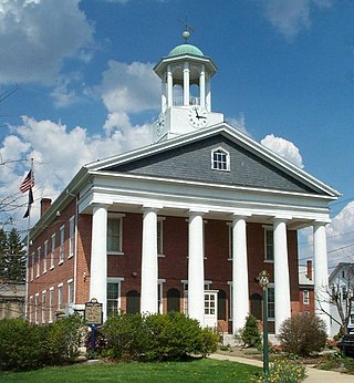
Fulton County is a county in the Commonwealth of Pennsylvania. As of the 2020 census, the population was 14,556, making it the fourth-least populous county in Pennsylvania. Its county seat is McConnellsburg. The county was created on April 19, 1850, from a part of Bedford County and named after inventor Robert Fulton.

<span class="mw-page-title-main">U.S. Route 522</span> Highway in the United States

U.S. Route 522 is a spur route of US 22 in the states of Virginia, West Virginia, Maryland, and Pennsylvania. The U.S. Highway travels in a north-south direction, and runs 308.59 miles (496.63 km) from US 60 near Powhatan, Virginia, to its northern terminus at US 11 and US 15 near Selinsgrove, Pennsylvania. US 522 serves many small cities and towns in the Piedmont, Blue Ridge Mountains, and northern Shenandoah Valley of Virginia. The highway serves the Virginia communities of Goochland, Mineral, Culpeper, the town of Washington, and Front Royal and the independent city of Winchester. US 522 then follows the Ridge-and-Valley Appalachians north and then east through the Eastern Panhandle of West Virginia, a 2-mile-wide (3.2 km) stretch of Western Maryland, and South Central Pennsylvania to its terminus in the Susquehanna Valley. The highway serves Berkeley Springs, West Virginia; Hancock, Maryland; and the Pennsylvania communities of McConnellsburg, Mount Union, Lewistown, and Middleburg.

<span class="mw-page-title-main">Syncline</span> Structural geology term for a fold with younger layers closer to the center of the structure

In structural geology, a syncline is a fold with younger layers closer to the center of the structure, whereas an anticline is the inverse of a syncline. A synclinorium is a large syncline with superimposed smaller folds. Synclines are typically a downward fold (synform), termed a synformal syncline, but synclines that point upwards can be found when strata have been overturned and folded.

<span class="mw-page-title-main">Breezewood, Pennsylvania</span> Unincorporated town in Pennsylvania, United States

Breezewood is an unincorporated town in East Providence Township, Bedford County in south-central Pennsylvania, United States.

<span class="mw-page-title-main">Sideling Hill Tunnel</span> Abandoned highway tunnel in Pennsylvania, United States of America

Sideling Hill Tunnel is one of three original Pennsylvania Turnpike tunnels abandoned after two massive realignment projects. The others are nearby Rays Hill Tunnel, and farther west, the Laurel Hill Tunnel. It was less expensive to realign the Turnpike than to bore a second tube for four lane traffic. Sideling Hill Tunnel is 6,782 feet (2,067 m) long.

<span class="mw-page-title-main">Rays Hill Tunnel</span>

Rays Hill Tunnel is one of three original Pennsylvania Turnpike tunnels that were abandoned after two massive realignment projects. The others included the Sideling Hill Tunnel, and farther west, the Laurel Hill Tunnel.

<span class="mw-page-title-main">Laurel Hill Tunnel</span> Abandonded tunnel in Pennsylvania, United States

Laurel Hill Tunnel is a 4,541-foot-long (1,384 m) tunnel on the Pennsylvania Turnpike that was bypassed and abandoned in 1964. It is bored through Laurel Ridge, spanning the border of Westmoreland and Somerset counties. Its western portal may be seen from the eastbound side of the Turnpike at milepost 99.3.

<span class="mw-page-title-main">Allegheny Mountain Tunnel</span> Vehicular tunnel carrying the Pennsylvania Turnpike through the Allegheny Mountains

The Abandoned Pennsylvania Turnpike is the common name of a 13-mile (21 km) stretch of the Pennsylvania Turnpike that was bypassed in 1968 when a modern stretch opened to ease traffic congestion in the tunnels. In this case, the Sideling Hill Tunnel and Rays Hill Tunnel were bypassed, as was one of the Turnpike's travel plazas. The bypass is located just east of the heavily congested Breezewood interchange for Interstate 70 (I-70) eastbound at what is now I-76 exit 161. The section of the turnpike was at one time part of the South Pennsylvania Railroad.

<span class="mw-page-title-main">Buchanan State Forest</span> State forest in Pennsylvania, United States

Buchanan State Forest is a Pennsylvania State Forest in Pennsylvania Bureau of Forestry District #2. The main office is located in McConnellsburg in Fulton County, Pennsylvania, in the United States. The forest also includes tracts in Franklin and Bedford Counties. It is named for James Buchanan of Pennsylvania, the fifteenth President of the United States.

<span class="mw-page-title-main">Interstate 70 in Pennsylvania</span> Section of Interstate highway in Pennsylvania, United States

Interstate 70 (I-70) is a state highway that is located in the Commonwealth of Pennsylvania in the United States. It runs east to west across the southwest part of Pennsylvania and serves the southern fringe of the Pittsburgh metropolitan area.

<span class="mw-page-title-main">Wills Mountain</span>

Wills Mountain is a quartzite-capped ridge in the Ridge and Valley physiographic province of the Appalachian Mountains in Pennsylvania and Maryland, extending from near Bedford, Pennsylvania, to near Cumberland, Maryland. It is the northernmost of several mountain ridges included within the Wills Mountain Anticline.

<span class="mw-page-title-main">U.S. Route 40 in Maryland</span> Section of U.S. Highway in Maryland, United States

U.S. Route 40 in the U.S. state of Maryland runs from Garrett County in Western Maryland to Cecil County in the state's northeastern corner. With a total length of 221 miles (356 km), it is the longest numbered highway in Maryland. Almost half of the road overlaps or parallels with Interstate 68 (I-68) or I-70, while the old alignment is generally known as US 40 Alternate, US 40 Scenic, or Maryland Route 144. West of Baltimore, in the Piedmont and Appalachian Mountains / Blue Ridge region of the Western Maryland panhandle of the small state, the portions where it does not overlap an Interstate highway are mostly two-lane roads. The portion northeast of Baltimore going toward Wilmington in northern Delaware and Philadelphia in southeastern Pennsylvania is a four-lane divided highway, known as the Pulaski Highway. This section crosses the Susquehanna River at the north end of the Chesapeake Bay on the Thomas J. Hatem Memorial Bridge.

<span class="mw-page-title-main">Pocono Formation</span>

The Mississippian Pocono Formation is a mapped bedrock unit in Pennsylvania, Maryland, and West Virginia, in the United States. It is also known as the Pocono Group in Maryland and West Virginia, and the upper part of the Pocono Formation is sometimes called the Burgoon Formation or Burgoon Sandstone in Pennsylvania. The Pocono is a major ridge-former In the Ridge-and-Valley Appalachians of the eastern United States

<span class="mw-page-title-main">Rays Hill</span>

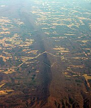
Rays Hill is a mountain ridge in Pennsylvania's Ridge and Valley Appalachians region. It is bordered to the east by Sideling Hill. About halfway along its run, the west side of Rays Hill ties into Broad Top Mountain, a large plateau.

<span class="mw-page-title-main">U.S. Route 40 Scenic</span> Highway in Maryland

U.S. Route 40 Scenic (US 40 Scenic) is a scenic route of US 40 in the U.S. state of Maryland. US 40 Scenic, which is known for most of its route as National Pike, is the old alignment of US 40 over Town Hill in eastern Allegany County and Sideling Hill in far western Washington County. The highway was originally constructed as part of a turnpike connecting Baltimore with the eastern end of the National Road at Cumberland in the early 19th century. The highway was paved as a modern road in the mid-1910s and designated US 40 in the late 1920s. US 40 was relocated over Sideling Hill in the early 1950s and over Town Hill in the mid-1960s. The US 40 Scenic designation was first applied to the old highway over Town Hill in 1965. Following the completion of Interstate 68 (I-68) at Sideling Hill, US 40 Scenic was extended east along old US 40's crossing of the mountain in the late 1980s. US 40 Scenic is the only scenic route in the U.S. Highway System; formerly, there was a second, US 412 Scenic in Oklahoma, but this has since been redesignated to a more conventional "Alternate" route.

<span class="mw-page-title-main">Gaps of the Allegheny</span>

The gaps of the Allegheny, meaning gaps in the Allegheny Ridge in west-central Pennsylvania, is a series of escarpment eroding water gaps along the saddle between two higher barrier ridge-lines in the eastern face atop the Allegheny Ridge or Allegheny Front escarpment. The front extends south through Western Maryland and forms much of the border between Virginia and West Virginia, in part explaining the difference in cultures between those two post-Civil War states. While not totally impenetrable to daring and energetic travelers on foot, passing the front outside of the water gaps with even sure footed mules was nearly impossible without navigating terrain where climbing was necessary on slopes even burros would find extremely difficult.

References

  1. 1 2 "Feature Detail Report for: Sideling Hill". Geographic Names Information System. United States Geological Survey. Retrieved January 20, 2014.
  2. "Fisher Point, Pennsylvania". List of Peaks. ListsOfJohn.com. Retrieved January 20, 2014.
  3. Walsh, Larry (November 4, 2001). "Cycling: Tighter security near Confluence dam sends cyclists in search of new campsite". Pittsburgh Post-Gazette . Archived from the original on May 25, 2007. Retrieved September 14, 2006.
  4. "Construction Information about the Sideling Hill Road Cut & Exhibit Center" (PDF). Maryland Department of Natural Resources. Retrieved June 29, 2021.
  5. 1 2 3 4 Brezinski, David K. (1994). "Geology of the Sideling Hill Road Cut". Maryland Geological Survey. Retrieved March 9, 2009.
  6. Keels, Heather (July 22, 2009). "Sideling Hill Exhibit Center to close". The Herald-Mail. Hagerstown, Maryland. Retrieved January 20, 2014.
  7. "Welcome Centers". Visit Maryland. Maryland Office of Tourism. Retrieved January 20, 2014.
  8. Baker, Tamela (September 25, 2015). "Sideling Hill visitors center to reopen in Hancock". Herald-Mail. Retrieved October 18, 2015.