Camelback Mountain (Big Pocono)

Last updated
Camelback Mountain (Big Pocono)

2bigpocono.jpg

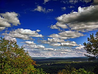
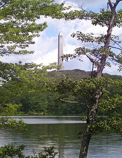
Big Pocono from Spring Lake
Highest point
Elevation 2,133 ft (650 m)
Geography
Location Monroe County, Pennsylvania, U.S.
Parent range Appalachian Mountains, Pocono Mountains

Camelback Mountain or Big Pocono is a conspicuous geographic feature on the Pocono Plateau. It is not a mountain, but rather a peninsular section of the Pocono Plateau, that when viewed from three sides, appears to be a mountain. The summit of Big Pocono "Mountain" is actually nearly level with land to the west and northwest, together comprising the top of the Glaciated Pocono Plateau, which is part of the larger Allegheny Plateau.

Plateau An area of a highland, usually of relatively flat terrain

In geology and physical geography, a plateau, also called a high plain or a tableland, is an area of a highland, usually consisting of relatively flat terrain, that is raised significantly above the surrounding area, often with one or more sides with steep slopes. Plateaus can be formed by a number of processes, including upwelling of volcanic magma, extrusion of lava, and erosion by water and glaciers. Plateaus are classified according to their surrounding environment as intermontane, piedmont, or continental.

Allegheny Plateau dissected plateau in the eastern United States

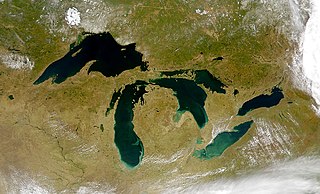
The Allegheny Plateau, in the United States, is a large dissected plateau area in western and central New York, northern and western Pennsylvania, northern and western West Virginia, and eastern Ohio. It is divided into the unglaciated Allegheny Plateau and the glaciated Allegheny Plateau.

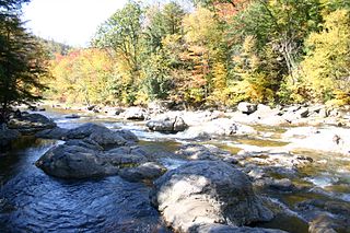
The Pocono Plateau, a distinctive geologic feature not to be confused with the larger Pocono Mountains, is a glaciated plateau formed during at least three glacial movements. As glaciers moved south from Canada, they scraped flat what is now the plateau. The Glacier Movements also created other distinctive features of this region, including peat bogs and swamps, which resulted when glacial scour produced un-drained scars on the plateau's surface. Examples of depressions created by glacial scour include Deep Lake and Wolf Swamp just west of Big Pocono State Park. [1]

Big Pocono State Park

Big Pocono State Park is a 1,305.6-acre (528.4 ha) Pennsylvania state park in Jackson and Pocono townships in Monroe County, Pennsylvania in northeastern Pennsylvania in the United States. The park is on Camelback Mountain and is maintained jointly by the Pennsylvania Department of Conservation and Natural Resources and Camelback Ski Corporation.

Big Pocono's distinctive shape, hence its nickname, and 1,000 ft prominence above land to the south, east, and north makes it plainly visible from the east and south. However, this feature is not apparent when viewed from the west.

In topography, prominence measures the height of a mountain or hill's summit relative to the lowest contour line encircling it but containing no higher summit within it. It is a measure of the independence of a summit. A peak's key col is a unique point on this contour line and the parent peak is some higher mountain, selected according to various objective criteria.

Big Pocono is home to a ski area called Camelback Mountain Resort and Big Pocono State Park. The park lies on the summit of the mountain, where there are hiking trails and picnic tables. Views from the summit are extensive. On a clear day the Delaware Water Gap, High Point (New Jersey) and the Catskill Mountains in New York State can be seen. [2]

Camelback Mountain Resort

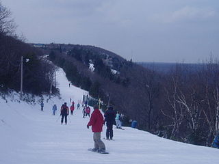
Camelback Mountain Resort is a ski and snowboard resort located in the Pocono Mountains region in Pocono Township and Jackson Township, Monroe County, Pennsylvania, adjacent to, and partially within Big Pocono State Park. In the 1950s when developers were working to expand the original solitary ski run, they negotiated with the then PA DER for permission to use a small portion of the state park for the ski area in exchange for $1 a year and the obligation to maintain the entire park.

Delaware Water Gap

The Delaware Water Gap is a water gap on the border of the U.S. states of New Jersey and Pennsylvania where the Delaware River cuts through a large ridge of the Appalachian Mountains. The gap constitutes the southern portion of the Delaware Water Gap National Recreation Area, which is used primarily for recreational purposes, such as rafting, canoeing, swimming, fishing, hiking, and rock climbing.

High Point (New Jersey) highest point in New Jersey

High Point is a mountain peak within High Point State Park on the border of Wantage Township and Montague Township, Sussex County, New Jersey, United States. Located in the portion of the state known as the Skylands, it is the highest elevation in the state, with a peak elevation of 1,803 feet. The closest city is Port Jervis, New York,which lies to the northwest. Besides being the highest peak in New Jersey, High Point is also the highest peak of the Kittatinny Mountains. Three states – New Jersey, New York, and Pennsylvania – can be seen from the top.

Related Research Articles

Monroe County, Pennsylvania County in the United States

Monroe County is a county in the U.S. state of Pennsylvania. As of the 2010 census, the population was 169,842. Its county seat is Stroudsburg. The county was formed from sections of Northampton and Pike counties. Named in honor of James Monroe, the fifth president of the United States, the county is located in northeastern Pennsylvania, along its border with New Jersey. Monroe County is coterminous with the East Stroudsburg, PA Metropolitan Statistical Area, within the Greater New York–Newark, NY–NJ–CT–PA Combined Statistical Area. It also borders the Lehigh Valley and has connections to the Delaware Valley, being a part of Philadelphia's Designated Media Market.

Kebnekaise Swedens highest mountain

Kebnekaise is the highest mountain in Sweden. The Kebnekaise massif, which is part of the Scandinavian Mountains, has two main peaks, of which the southern, glaciated one is highest at 2,097.5 metres (6,882 ft) above sea level as of August 2014. The northern peak is 2,096.8 metres (6,879 ft) and free of ice. Kebnekaise lies in Swedish Lapland, about 150 kilometres (93 mi) north of the Arctic Circle and west of Kiruna near the Kungsleden hiking trail between Abisko and Hemavan.

Glaciated Allegheny Plateau

The Glaciated Allegheny Plateau is that portion of the Allegheny Plateau that lies within the area covered by the last glaciation. As a result, this area of the Allegheny Plateau has lower relief and gentler slopes than the relatively rugged Unglaciated Allegheny Plateau. In general, the glaciated lies to the north and west of the unglaciated, and forms an arc in northeastern to southeastern Ohio lying between the glacial till plains and the Unglaciated Allegheny Plateau. The Glaciated Allegheny Plateau extends into a belt of southern New York State and the central Susquehanna River basin.

Pocono Mountains geographical, geological, and cultural region located in northeastern Pennsylvania, United States

The Pocono Mountains, commonly referred to as The Poconos, are a geographical, geological, and cultural region in Northeastern Pennsylvania, United States. The Poconos are an upland of the larger Allegheny Plateau. Forming a 2,400-square-mile (6,200 km2) escarpment overlooking the Delaware River and Delaware Water Gap to the east, the mountains are bordered on the north by Lake Wallenpaupack, on the west by the Wyoming Valley and the Coal Region, and to the south by the Lehigh Valley. The name comes from the Munsee word Pokawachne, which means "Creek Between Two Hills." Much of the Poconos region lies within the Greater New York-Newark, NY-NJ-CT-PA Combined Statistical Area. The wooded hills and valleys have long been a popular recreation area, accessible within a two-hour drive to millions of metropolitan area residents, with many communities having resort hotels with fishing, hunting, skiing, and other sports facilities.

Glacial lake lake formed by a melted glacier

A glacial lake is a body of freshwater with origins from glacier activity. They are formed when a glacier erodes the land, and then melts, filling the indentation created by the weight of the glacier.

Northeastern Pennsylvania Place in Pennsylvania, United States

Northeastern Pennsylvania (NEPA) is a geographic region of the U.S. state of Pennsylvania that includes the Pocono Mountains, the Endless Mountains, and the industrial cities of Scranton, Wilkes-Barre, Pittston, Hazleton, Nanticoke, and Carbondale. A portion of this region constitutes a part of the New York City metropolitan area.

Hickory Run State Park

Hickory Run State Park is a 15,990-acre (6,471 ha) Pennsylvania state park in Kidder and Penn Forest Townships in Carbon County, Pennsylvania in the United States. The park is spread across the Pocono Mountains. The park is easily accessible from Interstate 476 and Interstate 80.

Agassiz Rock Park in Massachusetts

Agassiz Rock is a 116-acre (47 ha) park in Manchester-by-the-Sea, Massachusetts, that is owned and maintained by The Trustees of Reservations. The park's name is from two examples of large glacial erratic boulders plucked from bedrock.

Blue Knob (Pennsylvania) mountain in Pennsylvania, USA

Blue Knob is a Pennsylvania summit with a broad dome that is the northernmost 3,000-footer in the range of Allegheny Mountains. It is the highest point in Bedford County.

Geology of Pennsylvania

The Geology of Pennsylvania consists of six distinct physiographic provinces, three of which are subdivided into different sections. Each province has its own economic advantages and geologic hazards and plays an important role in shaping everyday life in the state. They are: the Atlantic Coastal Plain Province, the Piedmont Province, the New England Province, the Ridge and Valley Province, the Appalachian Plateau Province, and the Central Lowlands Province.

Fluvioglacial landforms are landforms molded by glacial meltwater. This discharge of glacial streams, both over the surface (supraglacial) and beneath the ice sheet (subglacial), is higher in the warmer summer months. As subglacial water often flows under pressure, it has a high velocity and is very turbulent. This high velocity enables it to transport a large amount of material which would not normally be transported in a regular stream of similar size; boulders thus transported may remain as glacial erratics in the post-glacial terrain. As this material is transported it makes contact with the underside of a glacier and erodes vertically from below by abrasion. This erosion creates subglacial valleys. When there is a decrease in discharge of the glacial steams, deposition occurs, and is responsible for large groupings of landforms like eskers and drumlins in glaciated areas.

Mt. Pisgah is a peak located in northeastern Pennsylvania's Glaciated Low Plateau region, also known as the Endless Mountains. The mountain peak lies next to a state park named after the mountain, Mt. Pisgah State Park. There is a hiking trail to the summit that has a view of the surrounding countryside, 1,000 feet (305 m) feet below. Stephen Foster lake is also located at the base of the mountain.

Huntley Mountain Formation

The Huntley Mountain Formation is a late Devonian and early Mississippian mapped bedrock unit in Pennsylvania, in the United States.

Bald Mountain (Pennsylvania) mountain in Pennsylvania, United States of America

Bald Mountain is a prominent peak in Lackawanna County which stands above the Wilkes-Barre and Scranton area and the Wyoming Valley. On the summit is an outcrop of Catskill conglomerate known as the "Pinnacle Rock". From the summit you may view the northernmost extension of the geologic province known as the Glaciated Low Plateaus section. The mountain itself is in the Ridge and Valley Appalachians. It is a great place for photography.

Pocono Summit, Pennsylvania Unincorporated area in Pennsylvania, United States

Pocono Summit is a small town located in Monroe County, Pennsylvania, United States. Parts of Pocono Summit are located in the municipalities of Coolbaugh and Tobyhanna townships.

Central Mountain mountain in Columbia County, Sullivan County, and Luzerne County, in Pennsylvania

Central Mountain is a mountain in Columbia County, Sullivan County, and Luzerne County, in Pennsylvania, United States. Its elevation is 2,247 feet (685 m) above sea level. The mountain is part of the Allegheny Front. Rock formations on the mountain include the Pocono Formation and the Duncannon Member of the Catskill Formation. It was historically known as North Mountain, but it was renamed Central Mountain in the late 1800s. The mountain is one of the most important sites on the Columbia County Natural Areas Inventory and it is inhabited by dozens of trees, shrubs, and herbaceous plants. Numerous birds and several amphibians and mammals are also found in the area.

References

  1. "Glaciated Pocono Plateau Section: Appalachian Plateaus Province". Pennsylvania Department of Conservation and Natural Resources, Bureau of Topographic and Geologic Survey. Retrieved May 4, 2013.
  2. "Big Pocono State Park". Pennsylvania Department of Conservation and Natural Resources . Retrieved 2007-03-10.

Coordinates: 41°02′31″N75°20′45″W / 41.0419°N 75.3458°W / 41.0419; -75.3458

Geographic coordinate system Coordinate system

A geographic coordinate system is a coordinate system that enables every location on Earth to be specified by a set of numbers, letters or symbols. The coordinates are often chosen such that one of the numbers represents a vertical position and two or three of the numbers represent a horizontal position; alternatively, a geographic position may be expressed in a combined three-dimensional Cartesian vector. A common choice of coordinates is latitude, longitude and elevation. To specify a location on a plane requires a map projection.