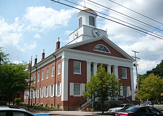
Bedford County is a county in the Commonwealth of Pennsylvania. As of the 2020 census, the population was 47,577. The county seat is Bedford.

Bedford Township is a township in Bedford County, Pennsylvania, United States. The population was 5,107 at the 2020 census.

Snake Spring Township is a township in Bedford County, Pennsylvania, United States. The population was 1,771 at the 2020 census.

Frankstown Township is a township in Blair County, Pennsylvania, United States. It is part of the Altoona Metropolitan Statistical Area. The population was 7,399 at the 2020 census. The township was named after Stephen Franks, a pioneer citizen.

The Juniata River is a tributary of the Susquehanna River, approximately 104 miles (167 km) long, in central Pennsylvania. The river is considered scenic along much of its route, having a broad and shallow course passing through several mountain ridges and steeply lined water gaps. It formed an early 18th-century frontier region in Pennsylvania and was the site of French-allied Native American attacks against English colonial settlements during the French and Indian War.

U.S. Route 522 is a spur route of US 22 in the states of Virginia, West Virginia, Maryland, and Pennsylvania. The U.S. Highway travels in a north-south direction, and runs 308.59 miles (496.63 km) from US 60 near Powhatan, Virginia, to its northern terminus at US 11 and US 15 near Selinsgrove, Pennsylvania. US 522 serves many small cities and towns in the Piedmont, Blue Ridge Mountains, and northern Shenandoah Valley of Virginia. The highway serves the Virginia communities of Goochland, Mineral, Culpeper, the town of Washington, and Front Royal and the independent city of Winchester. US 522 then follows the Ridge-and-Valley Appalachians north and then east through the Eastern Panhandle of West Virginia, a 2-mile-wide (3.2 km) stretch of Western Maryland, and South Central Pennsylvania to its terminus in the Susquehanna Valley. The highway serves Berkeley Springs, West Virginia; Hancock, Maryland; and the Pennsylvania communities of McConnellsburg, Mount Union, Lewistown, and Middleburg.

The Frankstown Branch Juniata River is a 46.0-mile-long (74.0 km) tributary of the Juniata River in Blair and Huntingdon counties, Pennsylvania, in the United States.

Bald Eagle Mountain – once known locally as Muncy Mountain – is a stratigraphic ridge in the Ridge-and-Valley Appalachians of central Pennsylvania, United States, running east of the Allegheny Front and northwest of Mount Nittany. It lies along the southeast side of Bald Eagle Creek and south of the West Branch Susquehanna River, and is the westernmost ridge in its section of the Ridge-and-Valley Appalachians. The ridge line separates the West Branch Susquehanna Valley from the Nippenose and White Deer Hole valleys, and Bald Eagle Valley from Nittany Valley.
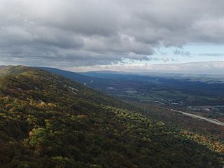
Brush Mountain is a stratigraphic ridge in the Appalachian Mountains of central Pennsylvania, United States, lying east of the Allegheny Front and west of Tussey Mountain. It runs along the southeast side of the Little Juniata River and forms a horseshoe around Sinking Run, and is the westernmost ridge in its section of the Ridge-and-valley Appalachians. The western ridge line separates the Logan Valley from the Sinking Valley.

Tussey Mountain is a stratigraphic ridge in central Pennsylvania, United States, trending east of the Bald Eagle, Brush, Dunning and Evitts Mountain ridges. Its southern foot just crosses the Mason–Dixon line near Flintstone, Maryland, running north 130 km (80 mi) to the Seven Mountains of central Pennsylvania, near Tusseyville, making it one of the longest named ridges in this section of the Ridge-and-valley Appalachians.

Bedford County, Pennsylvania is situated along the western border of the Ridge and Valley physiographic province, which is characterized by folded and faulted sedimentary rocks of early to middle Paleozoic age. The northwestern border of the county is approximately at the Allegheny Front, a geological boundary between the Ridge and Valley Province and the Allegheny Plateau.
Canoe Mountain is a stratigraphic ridge in central Pennsylvania, United States, running east of the Allegheny Front and west of Tussey Mountain. It forms a continuous ridge with Brush Mountain to the west. To the south, across the water gap formed by the Frankstown Branch Juniata River, the ridgeline continues as Lock Mountain.
The Pennsylvania State Game Lands Number 41 are Pennsylvania State Game Lands in Bedford and Blair Counties in Pennsylvania in the United States providing hunting, bird watching, and other activities.
The Pennsylvania State Game Lands Number 73 are Pennsylvania State Game Lands in Bedford, Blair and Huntingdon Counties in Pennsylvania in the United States providing hunting, bird watching, and other activities.
The Pennsylvania State Game Lands Number 97 are Pennsylvania State Game Lands in Bedford County in Pennsylvania in the United States providing hunting, bird watching, and other activities.
The Pennsylvania State Game Lands Number 118 are Pennsylvania State Game Lands in Blair and Huntingdon counties in Pennsylvania in the United States, providing hunting, bird watching, and other activities.
The Pennsylvania State Game Lands Number 147 are Pennsylvania State Game Lands in Blair County in Pennsylvania in the United States providing hunting, trapping, bird watching, and other activities.
The Pennsylvania State Game Lands Number 158 are Pennsylvania State Game Lands in Blair and Cambria counties in Pennsylvania in the United States, providing hunting, trapping, bird watching, and other activities.
The Pennsylvania State Game Lands Number 166 are Pennsylvania State Game Lands in Blair and Huntingdon Counties in Pennsylvania in the United States providing hunting, trapping, bird watching, and other activities.
The Pennsylvania State Game Lands Number 33 are Pennsylvania State Game Lands in Centre County in Pennsylvania in the United States providing hunting, bird watching, and other activities.
