
The Appalachian Trail, also called the A.T., is a hiking trail in the Eastern United States, extending almost 2,200 miles (3,540 km) between Springer Mountain in Georgia and Mount Katahdin in Maine, and passing through 14 states. The Appalachian Trail Conservancy claims the Appalachian Trail to be the longest hiking-only trail in the world. More than three million people hike segments of the trail each year.

Lehigh County is a county in the Commonwealth of Pennsylvania. As of the 2020 census, the county's population was 374,557. Its county seat is Allentown, the state's third-largest city after Philadelphia and Pittsburgh.

Heidelberg Township is a township in Lehigh County, Pennsylvania, United States. The population of Heidelberg Township was 3,416 at the 2010 census. It is a suburb of Allentown in the Lehigh Valley, which had a population of 861,899 and was the 68th-most populous metropolitan area in the U.S. as of the 2020 census.

Lehigh Township is a township in Northampton County, Pennsylvania, United States. The population of Lehigh Township was 10,526 as of the 2010 census. It is part of the Lehigh Valley metropolitan area, which had a population of 861,899 and was the 68th-most populous metropolitan area in the U.S. as of the 2020 census.
Springer Mountain is a mountain located in the Chattahoochee National Forest on the border of Fannin and Gilmer counties. Located in the Blue Ridge Mountains in northern Georgia, the mountain has an elevation of about 3,770 feet (1,149 m). Springer Mountain serves as the southern terminus for the Appalachian and Benton MacKaye trails.

Blue Mountain, Blue Mountain Ridge, or the Blue Mountains of Pennsylvania is a ridge of the Appalachian Mountains in eastern Pennsylvania. Forming the southern and eastern edge of the Ridge-and-Valley Appalachians physiographic province in Pennsylvania, Blue Mountain extends 150 miles (240 km) from the Delaware Water Gap on the New Jersey border in the east to Big Gap in Franklin County in south-central Pennsylvania at its southwestern end.

Hawk Mountain is a mountain ridge, part of the Blue Mountain Ridge in the Appalachian Mountain chain, located in central-eastern Pennsylvania near Reading and Allentown. The area includes 13,000 acres (5,300 ha) of protected private and public land, including the 2,600-acre (1,100 ha) Hawk Mountain Sanctuary.
The Appalachian National Scenic Trail spans 14 U.S. states over its roughly 2,200 miles (3,500 km): Georgia, North Carolina, Tennessee, Virginia, West Virginia, Maryland, Pennsylvania, New Jersey, New York, Connecticut, Massachusetts, Vermont, New Hampshire, and Maine. The southern end is at Springer Mountain, Georgia, and it follows the ridgeline of the Appalachian Mountains, crossing many of its highest peaks and running almost continuously through wilderness before reaching the northern end at Mount Katahdin, Maine.
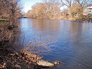
Jordan Creek is a 34.1-mile-long (54.9 km) tributary of Little Lehigh Creek in Lehigh County, Pennsylvania.

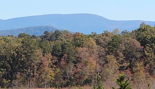
Mount Oglethorpe is a mountain located in Pickens County, Georgia, United States. The southernmost peak in the Blue Ridge Mountains, the mountain has an elevation of 3,288 feet (1,002 m), making it the highest point in Pickens County, and the Atlanta Metropolitan Area.

Laurel Ridge State Park is a 13,625-acre (5,514 ha) Pennsylvania state park that with parcels in Cambria, Fayette, Somerset, and Westmoreland counties, Pennsylvania in the United States.

Waterrock Knob is a mountain peak in the U.S. state of North Carolina. It is the highest peak in the Plott Balsams and is the 16th-highest mountain in the Eastern United States.

Tricorner Knob is a mountain in the Great Smoky Mountains, located in the southeastern United States. It has an elevation of 6,120 feet, with 160 feet of clean prominence. The Appalachian and Balsam Mountain trails intersect near the mountain's summit, making Tricorner Knob the great crossroads of the eastern Smokies.
Newside is a small hamlet in Lehigh County, Pennsylvania, located four miles west of the town of Neffs, at the corner of Park Avenue and Newside Road. It is part of the Lehigh Valley metropolitan area.

The Darlington Trail is a hiking trail of 7.7 miles (12.4 km) in south-central Pennsylvania. Its western end is at a junction with the Tuscarora Trail and the Appalachian Trail. Its eastern end is northwest of Harrisburg at Tower Road, which is only accessible for rugged vehicles.
Hawk Mountain Sanctuary is a wild bird sanctuary in Albany Township and East Brunswick Township, located along the Appalachian flyway in eastern Pennsylvania. The sanctuary is a prime location for the viewing of kettling and migrating raptors, known as hawkwatching, with an average of 20,000 hawks, eagles and falcons passing the lookouts during the late summer and fall every year.

Spruce Mountain, located in eastern West Virginia, is the highest ridge of the Allegheny Mountains. The whale-backed ridge extends for only 16 miles (26 km) from northeast to southwest, but several of its peaks exceed 4,500 feet (1,400 m) in elevation. The summit, Spruce Knob, is the highest Allegheny Mountain point both in the state and the entire range, which spans four states.

The Rocky Run shelter(s) are backcountry shelters located on the Appalachian Trail near Boonsboro, Maryland. They are situated next to the Rocky Run spring and a steep hill side. The original Rocky Run shelter sleeps six people, has a flat floor, and provides enough space to sit up. The new shelter can sleep up to sixteen and features a wood floor and a plywood-floored loft, as well as a covered front deck and large windows which flood the shelter with light. Accommodations available include two decks, a grill pit, porch swing, and semi-enclosed privy.
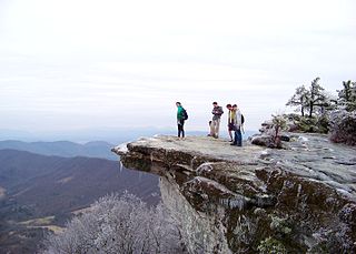
McAfee Knob is a geological feature with an elevation of 3,197 feet (974 m) above sea level, located on Catawba Mountain in Catawba, Virginia. It is named for a Scottish-Irish 18th-century settler. Considered to be among the most iconic points along the Appalachian Trail, the vista offers panoramic views of the Catawba Valley, 1,600 feet (490 m) below.

Rocky Knob Recreation Area is a 4,500 acres (18 km2) recreation area along the Blue Ridge Parkway, which spans from mile markers 167–174. The park is home to 15 miles of hiking trails, 81 tents camping sites, 28 RV sites, and 72 picnic sites. The campground is open seasonally, typically from May–October. Rocky Knob is also home to Rock Castle Gorge, a 3,500 acres (14 km2) gorge, and home to the Rock Castle Gorge National Recreation Trail. The trail drops 1,000 feet in elevation in 3 miles, and backpackers can request a backcountry camping permit from the National Park Service.


