The Appalachian Mountains, often called the Appalachians, are a system of mountains in eastern to northeastern North America. The Appalachians first formed roughly 480 million years ago during the Ordovician Period. They once reached elevations similar to those of the Alps and the Rocky Mountains before experiencing natural erosion. The Appalachian chain is a barrier to east–west travel, as it forms a series of alternating ridgelines and valleys oriented in opposition to most highways and railroads running east–west.

The Ridge-and-Valley Appalachians, also called the Ridge and Valley Province or the Valley and Ridge Appalachians, are a physiographic province of the larger Appalachian division and are also a belt within the Appalachian Mountains extending from southeastern New York through northwestern New Jersey, westward into Pennsylvania and southward into Maryland, West Virginia, Virginia, Kentucky, Tennessee, Georgia and Alabama. They form a broad arc between the Blue Ridge Mountains and the Appalachian Plateau physiographic province. They are characterized by long, even ridges, with long, continuous valleys in between.

The Allegheny Front is the major southeast- or east-facing escarpment in the Allegheny Mountains in southern Pennsylvania, western Maryland, and eastern West Virginia, USA. The Allegheny Front forms the boundary between the Ridge-and-Valley Appalachians to its east and the Appalachian Plateau to its west. The Front is closely associated with the Appalachian Mountains' Eastern Continental Divide, which in this area divides the waters of the Ohio/Mississippi river system, flowing to the Gulf of Mexico, from rivers flowing into Chesapeake Bay and from there into the Atlantic Ocean.

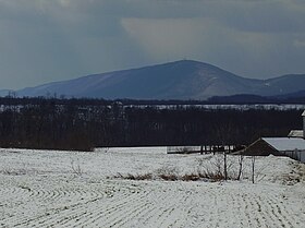
Blue Mountain, Blue Mountain Ridge, or the Blue Mountains of Pennsylvania is a ridge of the Appalachian Mountains in the U.S. state of Pennsylvania. Forming the southern and eastern edge of the Ridge-and-Valley Appalachians physiographic province in Pennsylvania, Blue Mountain extends 150 miles (240 km) from the Delaware Water Gap on the New Jersey border in the east to Big Gap in Franklin County, south-central Pennsylvania, at its southwestern end.

Mill Creek Mountain is a continuous mountain ridge that runs northeast through Hampshire and Hardy counties in the Eastern Panhandle region of the U.S. state of West Virginia. Rising to its greatest elevation of 2,650 feet (808 m) at High Knob, Mill Creek is a folded mountain ridge, belonging to the Ridge-and-Valley Appalachians. Mill Creek Mountain forms the western edge of the South Branch Potomac River Valley and is named for Mill Creek that carves through it at Mechanicsburg Gap allowing the Northwestern Turnpike to pass through as well. Along with Sawmill Ridge, Mill Creek Mountain forms the Trough along the South Branch.
South Mountain is the northern extension of the Blue Ridge Mountain range in Maryland and Pennsylvania. From the Potomac River near Knoxville, Maryland, in the south, to Dillsburg, Pennsylvania, in the north, the 70-mile-long (110 km) range separates the Hagerstown and Cumberland valleys from the Piedmont regions of the two states. The Appalachian National Scenic Trail follows the crest of the mountain through Maryland and a portion of Pennsylvania.

Dick's Knob or Dicks Knob, with an elevation of 4,620 feet (1,408 m), is the third-highest peak in the State of Georgia if using a 200 ft. prominence rule. It is located in Rabun County, Georgia within the Southern Nantahala Wilderness and is the second-highest mountain in the county.
Powell Mountain is a mountain ridge of the Ridge-and-valley Appalachians of the Appalachian Mountains. It is a long and narrow ridge, running northeast to southwest, from about Norton, Virginia to near Tazewell, Tennessee. It separates the Clinch River basin and the Powell River basin of Powell Valley. It was named for an 18th-century explorer.
The Appalachian National Scenic Trail spans fourteen U.S. states during its roughly 2,200 miles (3,500 km)-long journey: Georgia, North Carolina, Tennessee, Virginia, West Virginia, Maryland, Pennsylvania, New Jersey, New York, Connecticut, Massachusetts, Vermont, New Hampshire, and Maine. The southern end is at Springer Mountain, Georgia, and it follows the ridgeline of the Appalachian Mountains, crossing many of its highest peaks and running almost continuously through wilderness before reaching the northern end at Mount Katahdin, Maine.

North Fork Mountain is a quartzite-capped mountain ridge in the Ridge and Valley physiographic province of the Allegheny Mountains of eastern West Virginia, USA. Kile Knob, at 4,588 feet, is the mountain's highest point, and Panther Knob and Pike Knob are nearly as high.

Wills Mountain is a quartzite-capped ridge in the Ridge and Valley physiographic province of the Appalachian Mountains in Pennsylvania and Maryland, United States, extending from near Bedford, Pennsylvania, to near Cumberland, Maryland. It is the northernmost of several mountain ridges included within the Wills Mountain Anticline.

Waterrock Knob is a mountain peak in the U.S. state of North Carolina. It is the highest peak in the Plott Balsams and is the 16th-highest mountain in the Eastern United States.

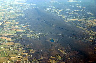
Big Mountain is the high point on the Tuscarora Mountain ridge in south central Pennsylvania in the United States. The 2,458-foot (749 m) summit is located in the Buchanan State Forest and offers an viewshed that is one of the more stunning in the Commonwealth.

The Silurian Tuscarora Formation — also known as Tuscarora Sandstone or Tuscarora Quartzite — is a mapped bedrock unit in Pennsylvania, Maryland, West Virginia, and Virginia, USA.

The Bear Pond Mountains are a sub-range in the Appalachian Mountains, that straddle Pennsylvania and Maryland in the United States. These mountains are a part of the Ridge and Valley Appalachians and reach their highest point at Cross Mountain (Pennsylvania) 2,062 feet (628 m). A unique geologic feature known as the "Punchbowl" occurs in this range. This feature was created by the weathered shales of the Ordovician age in the center of a south-plunging anticline, having been eroded to expose a large amphitheater-like feature (punchbowl). Cross and Hearthstone Mountain are made of hard resistant quartzite of the Tuscarora Formation of the Silurian age, which form the walls of the bowl.

Marks Knob is a mountain in the Great Smoky Mountains, in the southeastern United States. It has an elevation of 6,169 feet (1,880 m), with 249 feet (76 m) of clean prominence. Its summit— located near the center of the Eastern Smokies amidst a dense stand of Southern Appalachian spruce-fir forest— is a popular bushwhacking destination and one of the most difficult-to-reach summits of the Southern Sixers.

Spruce Mountain, in eastern West Virginia, USA, is the highest ridge of the Allegheny Mountains. The "whale-backed" ridge extends for only about 16 miles (26 km), from northeast to southwest, but several of its peaks exceed 4,500 feet (1,400 m) in elevation. The summit, Spruce Knob, is celebrated as the highest point in the state as well as the range, which covers parts of four states.

Nesquehoning Mountain or Nesquehoning Ridge is a 15–17-mile-long (24–27 km) coal bearing ridge dividing the waters of Lehigh Valley to the north from the Schuylkill River valley and the several near parallel ridgelines of the Ridge-and-valley Appalachians barrier range all local members of which run generally WSW-ENE in the greater overall area.