Related Research Articles

Frankstown Township is a township in Blair County, Pennsylvania, United States. It is part of the Altoona Metropolitan Statistical Area. The population was 7,399 at the 2020 census. The township was named after Stephen Franks, a pioneer citizen.

Huston Township is a township in Blair County, Pennsylvania, United States. It is part of the Altoona, PA Metropolitan Statistical Area. The population was 1,251 at the 2020 census.

Huston Township is an American township which is located in Centre County, Pennsylvania. It is part of the State College, Pennsylvania Metropolitan Statistical Area.

Worth Township is a township in Centre County, Pennsylvania, United States. It is part of the State College, Pennsylvania Metropolitan Statistical Area. The population was 734 at the 2020 census.

Lawrence Township is a township in Clearfield County, Pennsylvania, United States. The population was 7,503 at the 2020 census. Lawrence Township borders the townships of Boggs, Bradford, Goshen, Huston, Knox, Pike and Pine in Clearfield County, as well as Benezette and Jay Townships in Elk County to the north. Lawrence Township borders the borough of Clearfield as well.

Cochranton is a borough in Crawford County, Pennsylvania, United States. The population was 1,124 at the 2020 census, down from 1,136 as of the 2010 census.

Jay Township is a township in Elk County, Pennsylvania, United States. The population was 1,956 at the 2020 census, down from 2,072 in 2010.

Jefferson Township is a township in Fayette County, Pennsylvania, United States. The population was 2,008 at the 2020 census, a decline from the figure of 2,008 tabulated in 2010. It is named for former president Thomas Jefferson, and many of the township's streets are named after other U.S. presidents. Frazier School District serves the area.

Saltillo is a borough in Huntingdon County, Pennsylvania, United States. The population was 346 at the 2010 census.

Tuscarora is a census-designated place (CDP) that is located in Schuylkill County, Pennsylvania, United States. The population was 980 at the time of the 2010 census.

Olaberria is a town and municipality located in the Goierri region of the province of Gipuzkoa, in the autonomous community of the Basque Country, northern Spain.
Tunnel Hill is an unincorporated community in central Bedford Township, Coshocton County, Ohio, United States. It lies in the valley of the Little Wakatomika Creek a few miles south of Warsaw, along State Route 60 at its intersection with State Route 541.
New Milltown is a historic stone mill and unincorporated community located in Salisbury Township, Lancaster County, Pennsylvania, United States.
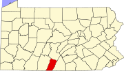
Morrisons Cove, is an eroded anticlinal valley in Blair and Bedford counties of central Pennsylvania, United States, extending from Evitts Mountain near New Enterprise, north to the Frankstown Branch Juniata River at Williamsburg. The width of the valley varies from 10 to 15 miles between Tussey Mountain on the east to the chain of Dunning, Loop and Lock Mountains on the west. Almost entirely enclosed by these mountains, the only openings in the cove are at Loysburg Gap in the south, McKee Gap in the west, and at Williamsburg to the north. The floor of the valley is mostly level, with many large fertile farm fields. The southern end of the valley drains to the Raystown Branch Juniata River via Yellow Creek through Loysburg Gap, and the northern end drains to the Frankstown Branch, via Clover Creek.

Balls Mills is an unincorporated community on Route 973 in Hepburn Township, Lycoming County, Pennsylvania. It is located seven miles north of Williamsport on Mill Creek, which flows southwest into the Lycoming Creek. English immigrant John Ball founded a saw mill in the village in the 1790s and, after he drowned, his son Bill Ball opened a wool mill and named the place Balls Mills with the apostrophe omitted. Blooming Grove Road provides access to Williamsport, where it becomes Market Street. The village uses the Cogan Station zip code of 17728.
Bloomingport is an unincorporated community in Washington Township, Randolph County, in the U.S. state of Indiana.
Napier is an extinct town in Holt County, in the U.S. state of Missouri. The GNIS classifies it as a populated place.
Middletown is an unincorporated community in Marion Township, Allen County, in the U.S. state of Indiana.