Johnson County, Georgia

Last updated

Johnson County
JOHNSON COUNTY COURTHOUSE.jpg
Johnson County Courthouse in Wrightsville
Map of Georgia highlighting Johnson County.svg
Location within the U.S. state of Georgia
Georgia in United States.svg
Georgia's location within the U.S.
Coordinates: 32°42′N82°40′W / 32.7°N 82.66°W / 32.7; -82.66
CountryFlag of the United States.svg United States
StateFlag of Georgia (U.S. state).svg  Georgia
FoundedDecember 11, 1858;165 years ago (1858-12-11)
Named for Herschel Vespasian Johnson
Seat Wrightsville
Largest cityWrightsville
Area
  Total307 sq mi (800 km2)
  Land303 sq mi (780 km2)
  Water3.6 sq mi (9 km2)  1.2%
Population
 (2020)
  Total9,189
  Density30/sq mi (10/km2)
Time zone UTC−5 (Eastern)
  Summer (DST) UTC−4 (EDT)
Congressional district 10th
Website www.johnsonco.org

Johnson County is a county located along the oconee River in the U.S. state of Georgia. As of the 2020 census, the population was 9,189. [1] The county seat is Wrightsville. [2] Johnson County is part of the Dublin, Georgia, micropolitan statistical area.

Contents

History

Johnson county was created by the Georgia legislature December 11, 1858, from parts of Emanuel, Laurens, and Washington counties. Johnson County was named for Georgia governor, senator, and U.S. vice-presidential candidate Herschel Vespasian Johnson. [3]

In 1919, a deputy driving Jim Waters, a black prisoner accused of rape, out of the county was stopped by a group of 150 men at a bridge over the Ohoopee River. The men tied Waters to a tree and shot him numerous times. The case was closed without any investigation. [4]

Geography

According to the U.S. Census Bureau, the county has a total area of 307 square miles (800 km2), of which 303 square miles (780 km2) is land and 3.6 square miles (9.3 km2) (1.2%) is water. [5]

The vast majority of Johnson County is located in the Ohoopee River sub-basin of the Altamaha River basin. Tiny portions of the northeastern borders of the county are located in the Upper Ogeechee River sub-basin of the Ogeechee River basin, while the western corner of Johnson County is located in the Lower Oconee River sub-basin of the Altamaha River basin. [6]

Major highways

Adjacent counties

Communities

Cities

Unincorporated community

Demographics

Historical population
CensusPop.Note
1860 2,919
1870 2,9641.5%
1880 4,80061.9%
1890 6,12927.7%
1900 11,40986.1%
1910 12,89713.0%
1920 13,5465.0%
1930 12,681−6.4%
1940 12,9532.1%
1950 9,893−23.6%
1960 8,048−18.6%
1970 7,727−4.0%
1980 8,66012.1%
1990 8,329−3.8%
2000 8,5602.8%
2010 9,98016.6%
2020 9,189−7.9%
2023 (est.)9,282 [7] 1.0%
U.S. Decennial Census [8]
1790-1880 [9] 1890-1910 [10]
1920-1930 [11] 1930-1940 [12]
1940-1950 [13] 1960-1980 [14]
1980-2000 [15] 2010 [16] 2020 [17]

2020 Census

Johnson County, Georgia – Racial and ethnic composition
Note: the US Census treats Hispanic/Latino as an ethnic category. This table excludes Latinos from the racial categories and assigns them to a separate category. Hispanics/Latinos may be of any race.
Race / Ethnicity (NH = Non-Hispanic)Pop 2000 [18] Pop 2010 [16] Pop 2020 [17] % 2000% 2010% 2020
White alone (NH)5,3076,2195,80062.00%62.31%63.12%
Black or African American alone (NH)3,1313,4613,01736.58%34.68%32.83%
Native American or Alaska Native alone (NH)1117230.13%0.17%0.25%
Asian alone (NH)1022280.12%0.22%0.30%
Pacific Islander alone (NH)13150.01%0.03%0.16%
Other race alone (NH)17140.01%0.07%0.15%
Mixed race or Multiracial (NH)21651750.25%0.65%1.90%
Hispanic or Latino (any race)781861170.91%1.86%1.27%
Total8,5609,9809,189100.00%100.00%100.00%

As of the 2020 United States census, there were 9,189 people, 3,393 households, and 2,208 families residing in the county.

Government

The county is governed by a five-member board of commissioners. A county manager handles the daily operation of the county.

The county is part of the Dublin Judicial Circuit along with Twiggs County, Treutlen County, and Laurens County.

United States presidential election results for Johnson County, Georgia [19]
Year Republican Democratic Third party
No.%No.%No.%
2020 2,85069.51%1,22229.80%280.68%
2016 2,51968.34%1,13630.82%310.84%
2012 2,44064.62%1,30534.56%310.82%
2008 2,42666.47%1,19832.82%260.71%
2004 2,27964.11%1,26335.53%130.37%
2000 1,79762.33%1,06536.94%210.73%
1996 81536.14%1,19452.95%24610.91%
1992 1,31439.88%1,47344.70%50815.42%
1988 1,56762.83%92737.17%00.00%
1984 1,73359.11%1,19940.89%00.00%
1980 1,12337.07%1,85461.21%521.72%
1976 69824.00%2,21076.00%00.00%
1972 2,20184.07%41715.93%00.00%
1968 38113.28%44615.55%2,04171.16%
1964 1,94073.99%68226.01%00.00%
1960 48827.32%1,29872.68%00.00%
1956 17910.02%1,60789.98%00.00%
1952 34415.99%1,80884.01%00.00%
1948 675.33%68554.54%50440.13%
1944 30423.71%97876.29%00.00%
1940 30611.32%2,38688.24%120.44%
1936 33415.15%1,86184.40%100.45%
1932 181.34%1,31498.06%80.60%
1928 28431.00%63269.00%00.00%
1924 19414.18%1,05877.34%1168.48%
1920 7419.47%30680.53%00.00%
1916 15016.95%71580.79%202.26%
1912 9223.00%28571.25%235.75%

Education

In 1970, Johnson County schools integrated peacefully due to careful planning by the county's board of education and firm management by superintendent Buren Claxton.

The county's public schools are located in Wrightsville. The school mascot is the Trojan, and the school colors are blue and white. The school fight song is the theme from the movie Hang 'Em High.

Sports

Herschel Walker, a Johnson County native, played on the county's only state championship football team in 1979. Walker went on to play for the University of Georgia and won the Heisman Trophy. In 2004 Johnson County High School named its football field for Walker.

See also

Related Research Articles

<span class="mw-page-title-main">Montgomery County, Georgia</span> County in Georgia, United States

Montgomery County is a county located in the central portion of the U.S. state of Georgia. As of the 2020 census, the population was 8,610. The county seat is Mount Vernon. Montgomery County is part of the Vidalia, GA micropolitan statistical area.

<span class="mw-page-title-main">Wheeler County, Georgia</span> County in Georgia, United States

Wheeler County is a county located in the central portion of the U.S. state of Georgia. As of the 2020 census, the population was 7,471. The county seat is Alamo. The county is one of the most impoverished counties in the nation. The American Community Survey's 2009–2013 average reports that the county's per-capita income of $8,948 makes it the poorest county in the United States by this metric. The measurement however is misleading as Wheeler County is the site of Wheeler Correctional Facility, a large prison with a capacity of 2,874 prisoners, about 40 percent of the county's total population. Most prisoners have little income. The prison was opened in 1998 and the prison population may also account for the increased population of the county in the early 2000s.

<span class="mw-page-title-main">Washington County, Georgia</span> County in Georgia, United States

Washington County is a county located in the U.S. state of Georgia. As of the 2020 census, the population was 19,988. The county seat is Sandersville. The county was established on February 25, 1784. It was named for Revolutionary War general George Washington.

<span class="mw-page-title-main">Walton County, Georgia</span> County in Georgia, United States

Walton County is a county located in the Middle Georgia portion of the U.S. - State of Georgia. As of the 2020 census, the population was 96,673. It is located about 30 miles east of the state capital, the city of Atlanta. Monroe is the county seat; Loganville is another major city.

<span class="mw-page-title-main">Twiggs County, Georgia</span> County in Georgia, United States

Twiggs County is a county located in the central portion of the U.S. state of Georgia. As of the 2020 census, the population was 8,022. The county seat is Jeffersonville. The county was created on December 14, 1809, and named for American Revolutionary War general John Twiggs.

<span class="mw-page-title-main">Treutlen County, Georgia</span> County in Georgia, United States

Treutlen County is a county located in the east central. & Magnolia midlands portion of the U.S. state of Georgia. As of the 2020 census, the population was 6,406. The county seat is Soperton. It is host to the Million Pines Arts and Crafts Festival which occurs during the first weekend in November.

<span class="mw-page-title-main">Toombs County, Georgia</span> County in Georgia, United States

Toombs County is a county located in the east central portion of the U.S. state of Georgia. As of the 2020 census, the population was 27,030. The county seat is Lyons and the largest city is Vidalia. The county was created on August 18, 1905.

<span class="mw-page-title-main">Peach County, Georgia</span> County in Georgia, United States

Peach County is a county located in the central portion of the U.S. state of Georgia. As of the 2020 census, the population was 27,981. Its county seat is Fort Valley. Founded in 1924, it is the state's newest county, taken from Houston and Macon counties on July 18 of that year. Its namesake is the peach on account of it being located in a peach-growing district.

<span class="mw-page-title-main">Newton County, Georgia</span> County in Georgia, United States

Newton County is a county located in the north central portion of the U.S. state of Georgia. As of the 2020 census, the population was 112,483. The county seat is Covington.

<span class="mw-page-title-main">Macon County, Georgia</span> County in Georgia, United States

Macon County is a county located in the west central portion of the U.S. state of Georgia. As of the 2020 census, the population was 12,082. The county seat is Oglethorpe.

<span class="mw-page-title-main">Laurens County, Georgia</span> County in Georgia, United States

Laurens County is a county located in the central part of the U.S. state of Georgia. As of the 2020 census, the population was 49,570, up from 48,434 in 2010. The county seat is Dublin. The county was founded on December 10, 1807, and named after Lieutenant Colonel John Laurens, an American soldier and statesman from South Carolina during the American Revolutionary War.

<span class="mw-page-title-main">Lamar County, Georgia</span> County in Georgia, United States

Lamar County is a county located in the west central portion of the U.S. state of Georgia. As of the 2020 census, the population was 18,500. The county seat is Barnesville.

<span class="mw-page-title-main">Jefferson County, Georgia</span> County in Georgia, United States

Jefferson County is a county located in the U.S. state of Georgia. As of the 2020 census, the population was 15,709. The county seat and largest city is Louisville. The county was created on February 20, 1796, and named for Thomas Jefferson, the main author of the Declaration of Independence who became the third president of the United States.

<span class="mw-page-title-main">Hancock County, Georgia</span> County in Georgia, United States

Hancock County is a county located in the East Central part of the U.S. state of Georgia. As of the 2020 census, the population was 8,735. The county seat is Sparta. The county was created on December 17, 1793, and named for John Hancock, a Founding Father of the American Revolution.

<span class="mw-page-title-main">Greene County, Georgia</span> County in Georgia, United States

Greene County is a county located in the east central portion & the Lake country region of the U.S. state of Georgia. As of the 2020 census, the population was 18,915. The county seat is Greensboro. The county was created on February 3, 1786, and is named for Nathanael Greene, an American Revolutionary War major general.

<span class="mw-page-title-main">Emanuel County, Georgia</span> County in Georgia, United States

Emanuel County is a county located in the magnolia midlands portion of the U.S. state of Georgia. As of the 2020 census, the population was 22,768. The county seat is Swainsboro.

<span class="mw-page-title-main">Clarke County, Georgia</span> County in Georgia, United States

Clarke County is located in the northeastern part of the U.S. state of Georgia. As of the 2020 census, the population was 128,671. Its county seat is Athens, with which it is a consolidated city-county. Clarke County is included in the Athens-Clarke County, GA Metropolitan Statistical Area, which is also included in the Atlanta-Athens-Clarke County-Sandy Springs, GA Combined Statistical Area.

<span class="mw-page-title-main">Candler County, Georgia</span> County in Georgia, United States

Candler County is a county located in the southeastern part of the U.S. state of Georgia. As of the 2020 census, the population was 10,981. The county seat is Metter. The county was founded in 1914 and named for Allen D. Candler, the 56th governor of Georgia.

<span class="mw-page-title-main">Barrow County, Georgia</span> County in Georgia, United States

Barrow County is a county located in the north central portion of the U.S. state of Georgia. As of the 2020 census, the population was 83,505. The county seat is Winder. Barrow County is included in the Atlanta-Sandy Springs-Roswell metropolitan statistical area.

<span class="mw-page-title-main">Wrightsville, Georgia</span> City in Georgia, United States

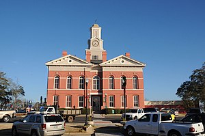
Wrightsville is a city in and the county seat of Johnson County, Georgia, United States. The population was 2,195 at the 2010 census, down from 2,223 at the 2000 census. By 2020, its population grew to 3,449. The city limits include Johnson State Prison on the northeast side of town. Wrightsville is part of the Dublin Micropolitan Statistical Area.

References

  1. "Census - Geography Profile: Johnson County, Georgia". United States Census Bureau . Retrieved December 27, 2022.
  2. "Find a County". National Association of Counties. Archived from the original on May 9, 2015. Retrieved June 7, 2011.
  3. Gannett, Henry (1905). The Origin of Certain Place Names in the United States. Govt. Print. Off. pp.  169.
  4. McWhirter, Cameron (2011). Red Summer: The Summer of 1919 and the Awakening of Black America. Henry Holt and Company. p. 52. ISBN   978-1-4299-7293-2.
  5. "US Gazetteer files: 2010, 2000, and 1990". United States Census Bureau. February 12, 2011. Retrieved April 23, 2011.
  6. "Georgia Soil and Water Conservation Commission Interactive Mapping Experience". Georgia Soil and Water Conservation Commission. Archived from the original on October 3, 2018. Retrieved November 20, 2015.
  7. "Annual Estimates of the Resident Population for Counties: April 1, 2020 to July 1, 2023". United States Census Bureau. Retrieved March 31, 2024.
  8. "Decennial Census of Population and Housing by Decades". United States Census Bureau.
  9. "1880 Census Population by Counties 1790-1800" (PDF). United States Census Bureau. 1880.
  10. "1910 Census of Population - Georgia" (PDF). United States Census Bureau. 1910.
  11. "1930 Census of Population - Georgia" (PDF). United States Census Bureau. 1930.
  12. "1940 Census of Population - Georgia" (PDF). United States Census Bureau. 1940.
  13. "1950 Census of Population - Georgia -" (PDF). United States Census Bureau. 1950.
  14. "1980 Census of Population - Number of Inhabitants - Georgia" (PDF). United States Census Bureau. 1980.
  15. "2000 Census of Population - Population and Housing Unit Counts - Georgia" (PDF). United States Census Bureau. 2000.
  16. 1 2 "P2: Hispanic or Latino, and Not Hispanic or Latino by Race – 2010: DEC Redistricting Data (PL 94-171) – Johnson County, Georgia". United States Census Bureau.
  17. 1 2 "P2: Hispanic or Latino, and Not Hispanic or Latino by Race – 2020: DEC Redistricting Data (PL 94-171) – Johnson County, Georgia". United States Census Bureau.
  18. "P004 Hispanic or Latino, and Not Hispanic or Latino by Race – 2000: DEC Summary File 1 – Johnson County, Georgia". United States Census Bureau.
  19. Leip, David. "Dave Leip's Atlas of U.S. Presidential Elections". uselectionatlas.org. Retrieved March 20, 2018.

32°42′N82°40′W / 32.70°N 82.66°W / 32.70; -82.66