Geology of Georgia (U.S. state)

Last updated
Generalized geologic regions of the state of Georgia (USA) Generalized geologic regions of Georgia.png
Generalized geologic regions of the state of Georgia (USA)
Physiographic regions of Georgia Ga geologic regions.gif
Physiographic regions of Georgia
Geologic map of Georgia Geologic Map of Georgia.png
Geologic map of Georgia

The U.S. state of Georgia is commonly divided into four geologic regions that influence the location of the state's four traditional physiographic regions. [1] [2] The four geologic regions include the Appalachian foreland, Blue Ridge, Piedmont, and Coastal Plain. These four geologic regions commonly share names with and typically overlap the four physiographic (i.e. topographic) regions of the state: the Appalachian Plateau and adjacent Valley and Ridge; the Blue Ridge; the Piedmont and the Coastal Plain.

Contents

The geologic regions of the state, established by geologists based on relationships between stratigraphic units, significantly influence the physiographic regional names used by physical geographers. Geologic regions of the state, however, do not perfectly coincide with physiographic regions of the state. Most geologic regions (terranes) in the state are separated from one another by major thrust faults that formed during the growth of the Appalachian Mountains. The Appalachian foreland, for example, is separated from the geologic Blue Ridge by the Talladega-Cartersville-Great Smoky fault. The geologic Blue Ridge is separated from the geologic Piedmont by the Brevard fault zone. The Fall Line, the surface expression of the Coastal Plain unconformity, is the geologic boundary between the Piedmont and the Coastal Plain.

Appalachian Foreland

The geological region known as the Appalachian foreland includes the phyisographic Valley and Ridge and Appalachian Plateau. The Appalachian foreland is dominated by sedimentary rocks that formed along the Paleozoic margin of North America both before and during growth of the Appalachian Mountains. [3] The Appalachian foreland of Georgia, which lies in the northwest corner of the state, is separated from metamorphic rocks of the western Blue Ridge by the Talladega-Cartersville-Great Smoky fault. The oldest rocks of the foreland include Cambrian-Ordovician stratigraphy of the Chilhowee Group, Shady Dolomite, Rome Formation, Conasauga Group, and Knox Group. Each of these rock units were deposited on the passive margin of North America after it rifted away from the supercontinent of Rodinia during the Neoproterozoic, but prior to the earliest phases of Appalachian mountain building in the Paleozoic. By the Early Ordovician Period (485 - 470 million years ago), a subduction zone had developed offshore of the North American continent (Laurentia) in the adjacent Iapetus Ocean. The formation of this subduction zone marks the transition from a passive to active tectonic margin for this part of ancient North America, and ultimately led to the tectonic activity that resulted in Appalachian [4] mountain building in this part of the orogen. In Georgia, Paleozoic sedimentary rocks of the Appalachian foreland younger than Early Ordovician in age were deposited as part of a retroarc and younger foreland basin along the flanks of the growing Appalachian mountains. Folded rock layers of the Valley and Ridge in Georgia, as well as their flat-lying equivalents in the Appalachian Plateau, include limestone, sandstone, shale and other sedimentary rocks. Many of these rocks serve as important economic resources in the state, including construction-grade limestone, barite, ochre and small amounts of coal. [5] The physiographic Valley and Ridge province owes its existence to folding of Paleozoic strata during the Alleghanian orogeny and the formation of Pangea. Many of the prominent, linear mountains in the Valley and Ridge province are classic hogback topographic features. The Appalachian foreland of Georgia is an excellent example of a foreland fold and thrust belt that develops during continental collisions. Rocks of the Appalachian Plateau, in the extreme northwest corner of the Appalachian foreland, are the relatively undeformed equivalents of folded and faulted strata in the folded Valley and Ridge physiographic region.

Blue Ridge

The Blue Ridge geologic region includes metamorphic rocks between the Appalachian foreland (i.e., southeast of the Talladega-Cartersville-Great Smoky fault) and the Piedmont region (i.e., northwest of the Brevard fault zone). Rocks of the geological Blue Ridge underlie the physiographic Blue Ridge region of the state, which are restricted to the North Georgia mountains. However, rocks of the geological Blue Ridge also underlie wide swaths of topography generally assigned to the physiographic Piedmont region. The highest points in Georgia, including Brasstown Bald, are underlain by rocks of the geological Blue Ridge. The Blue Ridge consists primarily of metamorphic rocks, which are the metamorphosed equivalents of sedimentary rocks or igneous rocks. The geological Blue Ridge is commonly divided by geologists into the western Blue Ridge and equivalent Talladega belt (Alabama and western Georgia), central Blue Ridge (northernmost Georgia), and eastern Blue Ridge terranes. The physiographic Blue Ridge region, which lies in the northernmost western Blue Ridge and central Blue Ridge geological terranes, marks the highest topography in the state. Rocks of the geological Blue Ridge, however, extend from the physiographic Blue Ridge, southwest across the state without holding up high mountains. The geological eastern Blue Ridge includes metavolcanic rocks of the Georgia Gold Belt. [5] From the discovery of gold in the Georgia Gold Belt in 1828, enough gold was mined in the area to cause a branch mint of the United States Mint to be located in Dahlonega, Georgia. The region also includes igneous intrusions of granite and diabase. [6] Marble and talc are other resources produced in the Blue Ridge in Georgia. [5] Rocks of the western Blue Ridge are interpreted to be metamorphosed equivalents of stratigraphy in the Appalachian foreland, all of which formed along the Paleozoic margin of ancient North America. Rocks of the eastern Blue Ridge in Georgia were deposited in a marginal basin (back-arc) basin between the Paleozoic North American continent and a volcanic arc terrane in the Iapetus Ocean. [7] Rocks of the central Blue Ridge record deep burial and metamorphic conditions attributed to the Taconic orogeny during the Middle-Late Ordovician, but rocks of the western and eastern Blue Ridge weren't metamorphosed until the Carbonifereous.

Piedmont

The Piedmont geologic region is composed of igneous and metamorphic rocks that include schist, amphibolite, gneiss, migmatite, and granite, among others. [5] This region is more hilly than mountainous and is marked by lower elevations than the physiographic Blue Ridge. The Piedmont physiographic region of Georgia is underlain by rocks of the geological Blue Ridge and geological Piedmont terranes. The geological Piedmont is limited to rocks southeast of the Brevard fault zone and northwest of the Coastal Plain unconformity (Fall Line), whereas the physiographic Piedmont stretches from the Fall Line to the Valley and Ridge across much of the state. The Piedmont is home to prominent features like Stone Mountain [5] and the Brevard fault zone, which runs parallel to the Chattahoochee River and bisects cities like Suwanee, Atlanta, Buford, and Duluth. The geological Piedmont includes metamorphic rocks of the Dadeville Complex, an Ordovican arc terrane that lay seaward of the North American continental margin and a fringing back-arc basin. It also includes rocks of the Opelika Complex, which are considered to be stratigraphic equivalents of rocks in the eastern Blue Ridge of Georgia and Alabama. Rocks of the Dadeville Complex, Opelika Complex, and Pine Mountain belt in southwestern Georgia comprise the western Inner Piedmont. Each of these geological terranes formed on the North American tectonic plate during the Neoproterozoic and Paleozoic. The southeastern portion of the geological Piedmont includes rocks of the Carolina terrane (Carolinia) and is interpreted to have formed along the ancient margin of Gondwana. Rocks of the Carolina terrane collided with ancient North American during the final stages of Appalachian mountain building, but remained sutured to the continent following the Mesozoic breakup of Pangea and the separation of Africa and South America during formation of the Atlantic Ocean. Rocks of the geological Piedmont terrane extend southeast beneath younger, flat-lying sedimentary rocks of the Coastal Plain.

Coastal Plain

The Coastal Plain of the U.S. Coastal Plain.jpg
The Coastal Plain of the U.S.

The Coastal Plain in Georgia is part of a geologic and physiographic region that extends from New Jersey to Texas and consists of sedimentary rocks deposited in the Late Cretaceous to Holocene periods. [8] It is divided from the Piedmont by the Fall Line, which passes through Georgia from Augusta in the east, then southwestward to Macon, then to Columbus and finally westward to Montgomery, Alabama. The Fall Line is the surface expression of the Coastal Plain unconformity, an erosional surface that separates younger, overlying rocks of the Coastal Plain from older igneous and metamorphic rocks of the Appalachian Piedmont beneath the unconformity. The Coastal Plain includes the Sandhills or Carolina Sandhills, a 10–35 mi (16–56 km) wide region within the Atlantic Coastal Plain province. [9] Rocks in the exposed Coastal Plain region of Georgia range from the Late Cretaceous Tuscaloosa Formation to modern Holocene sediments actively forming along the Atlantic coast. In the subsurface, Triassic basalts of the South Georgia Rift lie beneath younger sedimentary deposits in extensive, regional grabens. Rocks of the Georgia Coastal Plain include marine and terrestrial fossils and rare fragments of dinosaurs. [10] The main mineral resource of the Coastal Plain in Georgia is kaolin. [5]

See also

Related Research Articles

Obduction is a geological process whereby denser oceanic crust is scraped off a descending ocean plate at a convergent plate boundary and thrust on top of an adjacent plate. When oceanic and continental plates converge, normally the denser oceanic crust sinks under the continental crust in the process of subduction. Obduction, which is less common, normally occurs in plate collisions at orogenic belts or back-arc basins.

<span class="mw-page-title-main">Geology of the Appalachians</span> Geologic description of the Appalachian Mountains

The geology of the Appalachians dates back more than 1.2 billion years to the Mesoproterozoic era when two continental cratons collided to form the supercontinent Rodinia, 500 million years prior to the development of the range during the formation of Pangea. The rocks exposed in today's Appalachian Mountains reveal elongate belts of folded and thrust faulted marine sedimentary rocks, volcanic rocks, and slivers of ancient ocean floor—strong evidences that these rocks were deformed during plate collision. The birth of the Appalachian ranges marks the first of several mountain building plate collisions that culminated in the construction of Pangea with the Appalachians and neighboring Anti-Atlas mountains near the center. These mountain ranges likely once reached elevations similar to those of the Alps and the Rocky Mountains before they were eroded.

<span class="mw-page-title-main">Geology of the United States</span> National geology

The richly textured landscape of the United States is a product of the dueling forces of plate tectonics, weathering and erosion. Over the 4.5 billion-year history of the Earth, tectonic upheavals and colliding plates have raised great mountain ranges while the forces of erosion and weathering worked to tear them down. Even after many millions of years, records of Earth's great upheavals remain imprinted as textural variations and surface patterns that define distinctive landscapes or provinces.

<span class="mw-page-title-main">Alleghanian orogeny</span> Mountain-forming event that formed the Appalachian and Allegheny Mountains

The Alleghanian orogeny or Appalachian orogeny is one of the geological mountain-forming events that formed the Appalachian Mountains and Allegheny Mountains. The term and spelling Alleghany orogeny was originally proposed by H.P. Woodward in 1957.

<span class="mw-page-title-main">Acadian orogeny</span> North American orogeny

The Acadian orogeny is a long-lasting mountain building event which began in the Middle Devonian, reaching a climax in the Late Devonian. It was active for approximately 50 million years, beginning roughly around 375 million years ago (Ma), with deformational, plutonic, and metamorphic events extending into the early Mississippian. The Acadian orogeny is the third of the four orogenies that formed the Appalachian Mountains and subsequent basin. The preceding orogenies consisted of the Grenville and Taconic orogenies, which followed a rift/drift stage in the Neoproterozoic. The Acadian orogeny involved the collision of a series of Avalonian continental fragments with the Laurasian continent. Geographically, the Acadian orogeny extended from the Canadian Maritime provinces migrating in a southwesterly direction toward Alabama. However, the northern Appalachian region, from New England northeastward into Gaspé region of Canada, was the most greatly affected region by the collision.

<span class="mw-page-title-main">Taconic orogeny</span> Mountain-building period that affected most of New England

The Taconic orogeny was a mountain building period that ended 440 million years ago (Ma) and affected most of modern-day New England. A great mountain chain formed from eastern Canada down through what is now the Piedmont of the east coast of the United States. As the mountain chain eroded in the Silurian and Devonian periods, sediment spread throughout the present-day Appalachians and midcontinental North America.

<span class="mw-page-title-main">Appalachian Highlands</span> Physiographic division of the United States

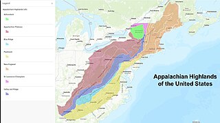
The Appalachian Highlands is one of eight government-defined physiographic divisions of the contiguous United States. The links with the Appalachian Uplands in Canada to make up the Appalachian Mountains. The Highlands includes seven physiographic provinces, which is the second level in the physiographic classification system in the United States. At the next level of physiographic classification, called section/subsection, there are 20 unique land areas with one of the provinces having no sections.

<span class="mw-page-title-main">Geology of Pennsylvania</span> Overview of the geology of the U.S. state of Pennsylvania

The Geology of Pennsylvania consists of six distinct physiographic provinces, three of which are subdivided into different sections. Each province has its own economic advantages and geologic hazards and plays an important role in shaping everyday life in the state. From the southeast corner to the northwest corner of the state, the include: the Atlantic Plain Province province, the Piedmont Province, the New England Province, the Ridge and Valley Province, the Appalachain Province, and the Central Lowlands Province.

New Jersey is a very geologically and geographically diverse region in the United States' Middle Atlantic region, offering variety from the Appalachian Mountains and the Highlands in the state's northwest, to the Atlantic Coastal Plain region that encompasses both the Pine Barrens and the Jersey Shore. The state's geological features have impacted the course of settlement, development, commerce and industry over the past four centuries.

<span class="mw-page-title-main">Geography of Georgia (U.S. state)</span> United States of America state geography

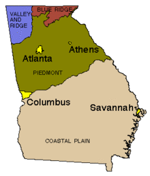
Georgia is a state in the Southeastern United States in North America. The Golden Isles of Georgia lie off the coast of the state. The main geographical features include mountains such as the Ridge-and-valley Appalachians in the northwest, the Blue Ridge Mountains in the northeast, the Piedmont plateau in the central portion of the state and Coastal Plain in the south. The highest area in Georgia is Brasstown Bald which is 1,458 m (4,783 ft) above sea level, while the lowest is at sea level, at the Atlantic Ocean. Georgia is located at approximately 33° N 83.5° W. The state has a total area of 154,077 km2 (59,489 sq mi) and the geographic center is located in Twiggs County.

<span class="mw-page-title-main">Geology of British Columbia</span>

The geology of British Columbia is a function of its location on the leading edge of the North American continent. The mountainous physiography and the diversity of the different types and ages of rock hint at the complex geology, which is still undergoing revision despite a century of exploration and mapping.

<span class="mw-page-title-main">Carolina terrane</span> Exotic terrane from central Georgia to central Virginia in the United States

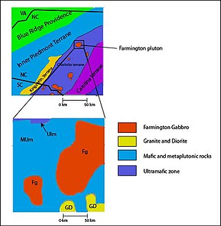
The Carolina Terrane, also called the Carolina Superterrane or Carolinia, is an exotic terrane running ~370 miles (600 km) approximately North-South from central Georgia to central Virginia in the United States. It constitutes a major part of the eastern Piedmont Province.

The Geographical Regions of South Carolina refers to the three major geographical regions of South Carolina: the Appalachian Mountains in the west, the central Piedmont region, and the eastern Atlantic Coastal Plain. The largest region in the state is the Piedmont, located between the Mountains and the Carolina Sandhills, while the smallest in region in the state is the Mountains, which are part of the Blue Ridge Mountains.

<span class="mw-page-title-main">Geology of North America</span> Overview of the geology of North America

The geology of North America is a subject of regional geology and covers the North American continent, the third-largest in the world. Geologic units and processes are investigated on a large scale to reach a synthesized picture of the geological development of the continent.

<span class="mw-page-title-main">Geology of Virginia</span>

The geology of Virginia began to form 1.8 billion years ago and potentially even earlier. The oldest rocks in the state were metamorphosed during the Grenville orogeny, a mountain building event beginning 1.2 billion years ago in the Proterozoic, which obscured older rocks. Throughout the Proterozoic and Paleozoic, Virginia experienced igneous intrusions, carbonate and sandstone deposition, and a series of other mountain building events which defined the terrain of the inland parts of the state. The closing of the Iapetus Ocean, to form the supercontinent Pangaea added additional small landmasses, some of which are now hidden beneath thick Atlantic Coastal Plain sediments. The region subsequently experienced the rifting open of the Atlantic Ocean in the Mesozoic, the development of the Coastal Plain, isolated volcanism and a series of marine transgressions that flooded much of the area. Virginia has extensive coal, deposits of oil and natural gas, as well as deposits of other minerals and metals, including vermiculite, kyanite and uranium.

The geology of Ohio formed beginning more than one billion years ago in the Proterozoic eon of the Precambrian. The igneous and metamorphic crystalline basement rock is poorly understood except through deep boreholes and does not outcrop at the surface. The basement rock is divided between the Grenville Province and Superior Province. When the Grenville Province crust collided with Proto-North America, it launched the Grenville orogeny, a major mountain building event. The Grenville mountains eroded, filling in rift basins and Ohio was flooded and periodically exposed as dry land throughout the Paleozoic. In addition to marine carbonates such as limestone and dolomite, large deposits of shale and sandstone formed as subsequent mountain building events such as the Taconic orogeny and Acadian orogeny led to additional sediment deposition. Ohio transitioned to dryland conditions in the Pennsylvanian, forming large coal swamps and the region has been dryland ever since. Until the Pleistocene glaciations erased these features, the landscape was cut with deep stream valleys, which scoured away hundreds of meters of rock leaving little trace of geologic history in the Mesozoic and Cenozoic.

The geology of Alaska includes Precambrian igneous and metamorphic rocks formed in offshore terranes and added to the western margin of North America from the Paleozoic through modern times. The region was submerged for much of the Paleozoic and Mesozoic and formed extensive oil and gas reserves due to tectonic activity in the Arctic Ocean. Alaska was largely ice free during the Pleistocene, allowing humans to migrate into the Americas.

<span class="mw-page-title-main">Geology of New York (state)</span> Overview of the geology of the U.S. state of New York

The geology of the State of New York is made up of ancient Precambrian crystalline basement rock, forming the Adirondack Mountains and the bedrock of much of the state. These rocks experienced numerous deformations during mountain building events and much of the region was flooded by shallow seas depositing thick sequences of sedimentary rock during the Paleozoic. Fewer rocks have deposited since the Mesozoic as several kilometers of rock have eroded into the continental shelf and Atlantic coastal plain, although volcanic and sedimentary rocks in the Newark Basin are a prominent fossil-bearing feature near New York City from the Mesozoic rifting of the supercontinent Pangea.

<span class="mw-page-title-main">Geology of North Carolina</span>

The geology of North Carolina includes ancient Proterozoic rocks belonging to the Grenville Province in the Blue Ridge. The region experienced igneous activity and the addition of new terranes and orogeny mountain building events throughout the Paleozoic, followed by the rifting of the Atlantic Ocean and the deposition of thick sediments in the Coastal Plain and offshore waters.

<span class="mw-page-title-main">Ashe Metamorphic Suite</span>

The Ashe Metamorphic Suite, also referred to as the Ashe Formation, was named after its type locality, Ashe County, North Carolina. The Ashe Metamorphic Suite is located in the Eastern Blue Ridge providence that extends from North Carolina up to South-Western Virginia. It is a collection of metamorphic rocks of both sedimentary and volcanic origin. Zircon dating indicates an age of 470 to 335 Ma for the unit. The protolith of the Ashe Metamorphic Suite was deposited during the Late Proterozoic and reaching its cooling age during the end of the Devonian. The Ashe Metamorphic Suite is overwhelmingly composed of amphibolites and mica schists.

References

  1. U.S. Geological Survey. "Georgia geological map data". U.S. Geological Survey, Online Spatial Data, Geology, by state. Retrieved July 13, 2023.
  2. Usery, Lynn (July 1, 2003). "Geographic Regions of Georgia". New Georgia Encyclopedia. Retrieved July 13, 2023.
  3. Ettensohn, Frank (2008). "The Appalachian foreland basin in eastern United States". Sedimentary Basins of the World. 5: 105–179. doi:10.1016/S1874-5997(08)00004-X via Science Direct.
  4. "Geologic Provinces of the United States: Appalachian Highlands Province". Geology in the Parks. United States Geological Survey . 2 October 2014. Archived from the original on 11 March 2013. Retrieved 12 June 2015.
  5. 1 2 3 4 5 6 "Geology of Georgia". Department of Geology . University of Georgia. Archived from the original on 22 June 2015. Retrieved 12 June 2015.
  6. Higgins, Michael W.; Crawford, Thomas J.; Atkins, Robert L.; Crawford, Ralph F. (2003). "Geologic map of the Atlanta 30' x 60' quadrangle, Georgia" (PDF). Geologic Investigations Series Map 1-2602. USGS. Archived (PDF) from the original on 14 June 2015. Retrieved 12 June 2015.
  7. Tull, Holm-Denoma, and Barineau (2014). "Early to Middle Ordovician back-arc basin in the southern Appalachian Blue Ridge: Characteristics, extent, and tectonic significance". GSA Bulletin. 126 (7–8): 990–1015. Bibcode:2014GSAB..126..990T. doi:10.1130/B30967.1.{{cite journal}}: CS1 maint: multiple names: authors list (link)
  8. "Geologic Provinces of the United States: Atlantic Plain Province". Geology in the Parks. USGS. 2 October 2014. Archived from the original on 11 March 2015. Retrieved 12 June 2015.
  9. Swezey, C.S., Fitzwater, B.A., Whittecar, G.R., Mahan, S.A., Garrity, C.P., Aleman Gonzalez, W.B., and Dobbs, K.M., 2016, "The Carolina Sandhills: Quaternary eolian sand sheets and dunes along the updip margin of the Atlantic Coastal Plain province, southeastern United States": Quaternary Research, v. 86, p. 271-286; www.cambridge.org/core/journals/quaternary-research
  10. Frazier, William J. (18 August 2014). "Coastal Plain Geologic Province". New Georgia Encyclopedia . Archived from the original on 14 June 2015. Retrieved 12 June 2015.