Jefferson County, Georgia

Last updated

Jefferson County
Jefferson County Courthouse, Louisville, GA, US (09).jpg
County courthouse in Louisville
Map of Georgia highlighting Jefferson County.svg
Location within the U.S. state of Georgia
Georgia in United States.svg
Georgia's location within the U.S.
Coordinates: 33°03′N82°25′W / 33.05°N 82.42°W / 33.05; -82.42
CountryFlag of the United States.svg United States
StateFlag of Georgia (U.S. state).svg  Georgia
FoundedFebruary 20, 1796;228 years ago (1796-02-20)
Named for Thomas Jefferson
Seat Louisville
Largest cityLouisville
Area
  Total530 sq mi (1,400 km2)
  Land526 sq mi (1,360 km2)
  Water3.2 sq mi (8 km2)  0.6%
Population
 (2020)
  Total15,709
  Density30/sq mi (10/km2)
Time zone UTC−5 (Eastern)
  Summer (DST) UTC−4 (EDT)
Congressional district 12th
Website Jefferson County, Georgia

Jefferson County is a county located in the U.S. state of Georgia. As of the 2020 census, the population was 15,709. [1] The county seat and largest city is Louisville. [2] The county was created on February 20, 1796, and named for Thomas Jefferson, the main author of the Declaration of Independence who became the third president of the United States. [3]

Contents

Geography

According to the U.S. Census Bureau, the county has a total area of 530 square miles (1,400 km2), of which 526 square miles (1,360 km2) is land and 3.2 square miles (8.3 km2) (0.6%) is water. [4]

The small northern portion of Jefferson County, defined by a line running from Stapleton southeast and just south of State Route 80, is located in the Brier Creek sub-basin of the Savannah River basin. The entire rest of the county is located in the Upper Ogeechee River sub-basin of the Ogeechee River basin. [5]

Major highways

Adjacent counties

Communities

Cities

Towns

Census-designated place

Demographics

Historical population
CensusPop.Note
1800 5,684
1810 6,1117.5%
1820 7,05615.5%
1830 7,3093.6%
1840 7,254−0.8%
1850 9,13125.9%
1860 10,21911.9%
1870 12,19019.3%
1880 15,67128.6%
1890 17,2139.8%
1900 18,2125.8%
1910 21,37917.4%
1920 22,6025.7%
1930 20,727−8.3%
1940 20,040−3.3%
1950 18,855−5.9%
1960 17,468−7.4%
1970 17,174−1.7%
1980 18,4037.2%
1990 17,408−5.4%
2000 17,266−0.8%
2010 16,930−1.9%
2020 15,709−7.2%
2023 (est.)15,183 [6] −3.3%
U.S. Decennial Census [7]
1790-1880 [8] 1890-1910 [9]
1920-1930 [10] 1930-1940 [11]
1940-1950 [12] 1960-1980 [13]
1980-2000 [14] 2010 [15] 2020 [16]
Jefferson County, Georgia – Racial and ethnic composition
Note: the US Census treats Hispanic/Latino as an ethnic category. This table excludes Latinos from the racial categories and assigns them to a separate category. Hispanics/Latinos may be of any race.
Race / Ethnicity (NH = Non-Hispanic)Pop 2000 [17] Pop 2010 [15] Pop 2020 [16] % 2000% 2010% 2020
White alone (NH)7,2157,0156,83441.79%41.44%43.50%
Black or African American alone (NH)9,6639,1877,97055.97%54.26%50.74%
Native American or Alaska Native alone (NH)2118210.12%0.11%0.13%
Asian alone (NH)2764700.16%0.38%0.45%
Pacific Islander alone (NH)1200.01%0.01%0.00%
Other race alone (NH)1613250.09%0.08%0.16%
Mixed race or Multiracial (NH)641143270.37%0.67%2.08%
Hispanic or Latino (any race)2595174621.50%3.05%2.94%
Total17,26616,93015,709100.00%100.00%100.00%

As of the 2020 United States census, there were 15,709 people, 5,664 households, and 3,598 families residing in the county.

Education

Politics

Jefferson County trends Democratic in presidential elections; having last supported a Republican in 1988 when it voted for George HW Bush. George W. Bush came within 381 votes of carrying the county in 2004. In the 2022 midterms, Governor Brian Kemp is presumably the first Republican to win statewide in Jefferson County since Sonny Perdue's re-election in 2006.[ citation needed ] It is now a Democratic-leaning swing county

United States presidential election results for Jefferson County, Georgia [18]
Year Republican Democratic Third party
No.%No.%No.%
2020 3,53746.30%4,05853.12%440.58%
2016 3,06343.91%3,82154.77%921.32%
2012 2,99941.08%4,26158.36%410.56%
2008 3,06142.31%4,14957.35%250.35%
2004 3,06646.89%3,44752.71%260.40%
2000 2,55945.98%2,97353.41%340.61%
1996 2,07735.86%3,40458.77%3115.37%
1992 2,07734.68%3,22053.77%69211.55%
1988 2,78854.13%2,34645.54%170.33%
1984 2,99951.57%2,81648.43%00.00%
1980 1,60532.24%3,30566.39%681.37%
1976 1,30929.59%3,11570.41%00.00%
1972 2,77770.11%1,18429.89%00.00%
1968 1,22723.51%1,90136.43%2,09040.05%
1964 2,95070.15%1,25329.80%20.05%
1960 98643.71%1,27056.29%00.00%
1956 51227.48%1,35172.52%00.00%
1952 74433.51%1,47666.49%00.00%
1948 1377.98%54431.70%1,03560.31%
1944 27420.80%1,04379.20%00.00%
1940 17113.72%1,06885.71%70.56%
1936 16811.85%1,23887.31%120.85%
1932 654.23%1,45494.66%171.11%
1928 1,05756.98%79843.02%00.00%
1924 10315.10%50273.61%7711.29%
1920 828.92%83791.08%00.00%
1916 637.91%58873.87%14518.22%
1912 453.31%89966.15%41530.54%

See also

Related Research Articles

<span class="mw-page-title-main">Washington County, Georgia</span> County in Georgia, United States

Washington County is a county located in the U.S. state of Georgia. As of the 2020 census, the population was 19,988. The county seat is Sandersville. The county was established on February 25, 1784. It was named for Revolutionary War general George Washington.

<span class="mw-page-title-main">Walton County, Georgia</span> County in Georgia, United States

Walton County is a county located in the Middle Georgia portion of the U.S. - State of Georgia. As of the 2020 census, the population was 96,673. It is located about 30 miles east of the state capital, the city of Atlanta. Monroe is the county seat; Loganville is another major city.

<span class="mw-page-title-main">Taliaferro County, Georgia</span> County in Georgia, United States

Taliaferro County is a county located in East central Piedmont region of the U.S. state of Georgia. As of the 2020 census, the population was 1,559, down from the 2010 census when the population was 1,717, making it the least populous county in Georgia and the second least populous county east of the Mississippi River. The county seat is Crawfordville.

<span class="mw-page-title-main">Talbot County, Georgia</span> County in Georgia, United States

Talbot County is a county located in the west central portion of the U.S. state of Georgia. The 2020 census showed a population of 5,733. The county seat and largest city is Talbotton.

<span class="mw-page-title-main">Richmond County, Georgia</span> Consolidated city-county in Georgia, United States

Richmond County is located in the state of Georgia in the U.S. As of the 2020 census, the population was 206,607. It is one of the original counties of Georgia, created on February 5, 1777. Following an election in 1995, Augusta consolidated governments with Richmond County. The consolidated entity is known as Augusta-Richmond County, or simply Augusta. Exempt are the cities of Hephzibah and Blythe, in southern Richmond County, which voted to remain separate. Richmond County is included in the Augusta-Richmond County, GA-SC metropolitan statistical area.

<span class="mw-page-title-main">Peach County, Georgia</span> County in Georgia, United States

Peach County is a county located in the central portion of the U.S. state of Georgia. As of the 2020 census, the population was 27,981. Its county seat is Fort Valley. Founded in 1924, it is the state's newest county, taken from Houston and Macon counties on July 18 of that year. Its namesake is the peach on account of it being located in a peach-growing district.

<span class="mw-page-title-main">Johnson County, Georgia</span> County in Georgia, United States

Johnson County is a county located along the oconee River in the U.S. state of Georgia. As of the 2020 census, the population was 9,189. The county seat is Wrightsville. Johnson County is part of the Dublin, Georgia, micropolitan statistical area.

<span class="mw-page-title-main">Hancock County, Georgia</span> County in Georgia, United States

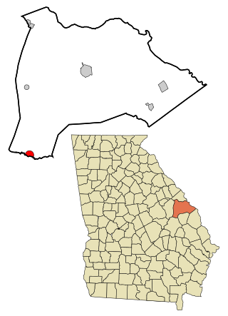
Hancock County is a county located in the East Central part of the U.S. state of Georgia. As of the 2020 census, the population was 8,735. The county seat is Sparta. The county was created on December 17, 1793, and named for John Hancock, a Founding Father of the American Revolution.

<span class="mw-page-title-main">Glascock County, Georgia</span> County in Georgia, United States

Glascock County is a county located in the U.S. state of Georgia. As of the 2020 census, the population was 2,884, making it the fourth-least populous county in Georgia. The county seat is Gibson. The county was created on December 19, 1857.

<span class="mw-page-title-main">Clinch County, Georgia</span> County in Georgia, United States

Clinch County is a county located in the southeastern part of the U.S. state of Georgia. As of the 2020 census, the population was 6,749. The county seat is Homerville. The county was created on February 14, 1850, named in honor of Duncan Lamont Clinch.

<span class="mw-page-title-main">Clarke County, Georgia</span> County in Georgia, United States

Clarke County is located in the northeastern part of the U.S. state of Georgia. As of the 2020 census, the population was 128,671. Its county seat is Athens, with which it is a consolidated city-county. Clarke County is included in the Athens-Clarke County, GA Metropolitan Statistical Area, which is also included in the Atlanta-Athens-Clarke County-Sandy Springs, GA Combined Statistical Area.

<span class="mw-page-title-main">Chatham County, Georgia</span> County in Georgia, United States

Chatham County is located in the U.S. state of Georgia, on the state's Atlantic coast. The county seat and largest city is Savannah. One of the original counties of Georgia, Chatham County was created February 5, 1777, and is named after William Pitt, 1st Earl of Chatham.

<span class="mw-page-title-main">Charlton County, Georgia</span> County in Georgia, United States

Charlton County is the southernmost county of the U.S. state of Georgia, located in the southeastern part of the state. As of the 2020 census, the population was 12,518. The county seat is Folkston.

<span class="mw-page-title-main">Burke County, Georgia</span> County in Georgia, United States

Burke County is a county located along the eastern border of the U.S. state of Georgia in the Piedmont. As of the 2020 census, the population was 24,596. The county seat is Waynesboro. Burke County is part of the Augusta-Richmond County, GA-SC metropolitan statistical area.

<span class="mw-page-title-main">Brantley County, Georgia</span> County in Georgia, United States

Brantley County is a county located in the southeastern part of the U.S. state of Georgia. As of the 2020 census, the population was 18,021. The county seat is Nahunta. Brantley County is part of the Brunswick, Georgia metropolitan statistical area.

<span class="mw-page-title-main">Barrow County, Georgia</span> County in Georgia, United States

Barrow County is a county located in the north central portion of the U.S. state of Georgia. As of the 2020 census, the population was 83,505. The county seat is Winder. Barrow County is included in the Atlanta-Sandy Springs-Roswell metropolitan statistical area.

<span class="mw-page-title-main">Baker County, Georgia</span> County in Georgia, United States

Baker County is a county in Georgia. As of the 2020 census, the population was 2,876. The county seat and only city is Newton. The county was created December 12, 1825, from the eastern portion of Early County by an act of the Georgia General Assembly and is named for Colonel John Baker, a hero of the American Revolutionary War.

<span class="mw-page-title-main">Midville, Georgia</span> City in Georgia, United States

Midville is a city in Burke County, Georgia, United States. The population was 269 at the 2010 census, and 385 in 2020. It is part of the Augusta, Georgia metropolitan area.

<span class="mw-page-title-main">Gibson, Georgia</span> City in Georgia, United States

Gibson is a city in Glascock County, Georgia, United States. The population was 663 at the 2010 census, and 630 in 2020. The city is the county seat of Glascock County and home to the Glascock County Courthouse, a National Register of Historic Places listed site.

<span class="mw-page-title-main">Bartow, Georgia</span> Town in Georgia, United States

Bartow is a town in Jefferson County, Georgia, United States. As of the 2020 census, the city had a population of 186. Initially the town was known as "Spier's Turnout", but was changed to honor the first Confederate officer to die in battle, Colonel Francis S. Bartow of Savannah, Georgia, who was killed at the Battle of Manassas, Virginia on July 21, 1861.

References

  1. "Census - Geography Profile: Jefferson County, Georgia". United States Census Bureau . Retrieved December 27, 2022.
  2. "Find a County". National Association of Counties. Archived from the original on May 31, 2011. Retrieved June 7, 2011.
  3. Gannett, Henry (1905). The Origin of Certain Place Names in the United States. Govt. Print. Off. pp.  168.
  4. "US Gazetteer files: 2010, 2000, and 1990". United States Census Bureau. February 12, 2011. Retrieved April 23, 2011.
  5. "Georgia Soil and Water Conservation Commission Interactive Mapping Experience". Georgia Soil and Water Conservation Commission. Archived from the original on October 3, 2018. Retrieved November 20, 2015.
  6. "Annual Estimates of the Resident Population for Counties: April 1, 2020 to July 1, 2023". United States Census Bureau. Retrieved March 31, 2024.
  7. "Decennial Census of Population and Housing by Decade". United States Census Bureau.
  8. "1880 Census Population by Counties 1790-1800" (PDF). United States Census Bureau. 1880.
  9. "1910 Census of Population - Georgia" (PDF). United States Census Bureau. 1910.
  10. "1930 Census of Population - Georgia" (PDF). United States Census Bureau. 1930.
  11. "1940 Census of Population - Georgia" (PDF). United States Census Bureau. 1940.
  12. "1950 Census of Population - Georgia -" (PDF). United States Census Bureau. 1950.
  13. "1980 Census of Population - Number of Inhabitants - Georgia" (PDF). United States Census Bureau. 1980.
  14. "2000 Census of Population - Population and Housing Unit Counts - Georgia" (PDF). United States Census Bureau. 2000.
  15. 1 2 "P2: Hispanic or Latino, and Not Hispanic or Latino by Race – 2010: DEC Redistricting Data (PL 94-171) – Jefferson County, Georgia". United States Census Bureau.
  16. 1 2 "P2: Hispanic or Latino, and Not Hispanic or Latino by Race – 2020: DEC Redistricting Data (PL 94-171) – Jefferson County, Georgia". United States Census Bureau.
  17. "P004 Hispanic or Latino, and Not Hispanic or Latino by Race – 2000: DEC Summary File 1 – Jefferson County, Georgia". United States Census Bureau.
  18. Leip, David. "Dave Leip's Atlas of U.S. Presidential Elections". uselectionatlas.org. Retrieved March 20, 2018.

33°03′N82°25′W / 33.05°N 82.42°W / 33.05; -82.42