Savannah River

Last updated

Savannah River
Tugaloo River
Savannah River Augusta Canal Riverwatch Pkwy 2.jpg
Savannah River at Augusta, with the Augusta Canal running alongside
Savannahrivermap.png
Map of the Savannah River watershed
Location
Country United States
State North Carolina, South Carolina, Georgia
Cities Savannah, Augusta
Physical characteristics
Source Lake Hartwell
  coordinates 34°26′37″N82°51′22″W / 34.44361°N 82.85611°W / 34.44361; -82.85611 [1]
  elevation655 ft (200 m) [2]
Mouth Atlantic Ocean
  location
Tybee Roads
  coordinates
32°2′16″N80°51′0″W / 32.03778°N 80.85000°W / 32.03778; -80.85000 [1]
  elevation
0 ft (0 m) [2]
Length301 mi (484 km)
Basin size9,850 sq mi (25,500 km2) [3]
Discharge 
  locationnear Clyo, GA [3]
  average11,720 cu ft/s (332 m3/s) [3]
Basin features
Tributaries 
  left Seneca River
  right Tugaloo River
Talmadge Memorial Bridge in Savannah Talmadge Memorial Bridge Savannah. GA, US.JPG
Talmadge Memorial Bridge in Savannah
A cargo ship navigates the narrow channel at Savannah Savannah river cargo ship.jpg
A cargo ship navigates the narrow channel at Savannah

The Savannah River is a major river in the Southeastern United States, forming most of the border between South Carolina and Georgia. Two tributaries of the Savannah, the Tugaloo River and the Chattooga River, form the northernmost part of the state border. The Savannah River drainage basin extends into the southeastern side of the Appalachian Mountains just inside North Carolina, bounded by the Eastern Continental Divide. The river is around 301 miles (484 km) long. [4] The Savannah was formed by the confluence of the Tugaloo River and the Seneca River. Today this confluence is part of Lake Hartwell. The Tallulah Gorge is located on the Tallulah River, a tributary of the Tugaloo River that forms the northwest branch of the Savannah River.

Contents

Two major cities are located along the Savannah River: Savannah and Augusta, Georgia. They were nuclei of early English settlements during the Colonial period of American history.

The Savannah River is tidal at Savannah proper. Downstream from there, the river broadens into an estuary before flowing into the Atlantic Ocean. The area where the river's estuary meets the ocean is known as "Tybee Roads". The Intracoastal Waterway flows through a section of the Savannah River near the city of Savannah.

Name

The name "Savannah" comes from a group of Shawnee who migrated to the Piedmont region in the 1680s. They destroyed the Westo and occupied established Westo lands at the Savannah River's head of navigation on the Fall Line. Present-day Augusta developed near there. [5] These Shawnee were called by several variant names, which all derive from their native name, Ša·wano·ki (literally, "southerners"). [6] The local variants included Shawano, Savano, Savana, and Savannah. [7]

Another theory is that the name was derived from the English term "savanna", a kind of tropical grassland, which was borrowed by the English from Spanish sabana and used in the colonial southeast. The Spanish word was borrowed from the Taino word zabana. [8] Other theories interpret the name Savannah to have come from Atlantic coastal tribes, who spoke Algonquian languages. These have similar terms meaning "southerner" or perhaps "salt". [9] [10]

Historical and variant names of the Savannah River, as listed by the U.S. Geological Survey, include May River, Westobou River (for the Westo tribe), Kosalu River, Isundiga River, and Girande River, among others. [1]

History

Ocean Steamship Company (Savannah Line), piers 34 and 35, at the foot of Spring and Canal Streets, 1893 (King1893NYC) pg101 OCEAN STEAMSHIP CO OF SAVANNAH, PIERS 34 AND 35, NORTH RIVER.jpg
Ocean Steamship Company (Savannah Line), piers 34 and 35, at the foot of Spring and Canal Streets, 1893

Early history

The Westo were thought to have migrated from the northeast, pushed out by the more powerful tribes of the Iroquois Confederacy, who had acquired firearms through trade. This migration, beginning in the late 16th century, resulted in the Westo Indians reaching the present area of Augusta, Georgia, in the late 17th century.[ citation needed ]

The Westo used the river for fishing and water supplies, for transportation, and for trade. They were strong enough to hold off the Spanish colonists making incursions from Spanish Florida. The Carolina Colony needed the Westo alliance during its early years. When Carolinians desired to expand their trade to Charleston, they viewed the Westo tribe as an obstacle. In order to remove the tribe, they sent a group called the Goose Creek Men to arm the Savanna (also known as the Savannah) Indians, a Shawnee tribe, who defeated the Westo in 1680.[ citation needed ]

Following this, the English colonists renamed the river as the Savannah; it was integral to early development. They founded two major cities on the river during the colonial era: Savannah was established in 1733 as a seaport on the Atlantic Ocean, and Augusta is located where the river crosses the Fall Line of the Piedmont, at the headwaters of the navigable portion of the river downstream to the ocean. The two cities on the Savannah served as Georgia's first two state capitals. In the 19th century, the sandy river channel changed frequently, causing numerous steamboat accidents.

During the American Civil War, President Abraham Lincoln proclaimed a blockade around the Confederate States of America, forcing merchantmen to use specific ports along the coast best suited for this purpose. The harbor at Savannah became one of the busiest ports for blockade runners bringing in supplies for the Confederacy until it was cut off by the reduction of Fort Pulaski and Union capture of Cockspur Island. [11]

The South Carolina-Georgia border was originally defined in the Treaty of Beaufort in 1787, which, among other things, "[reserved] all islands in [the river] to Georgia". Over time, new islands were created. Some, namely the Barnwell islands, are on the South Carolina side of the original line. In 1990, the U.S. Supreme Court decided that the new islands on the South Carolina side of the border belong to South Carolina. [12]

20th century to present

Between 1946 and 1985, the U.S. Army Corps of Engineers built three major dams on the Savannah for hydroelectricity, flood control, and navigation. The J. Strom Thurmond Dam (1954), the Hartwell Dam (1962), and the Richard B. Russell Dam (1985) and their reservoirs combine in order to form over 120 miles (190 km) of lakes. [13] In December 1986, an oil spill caused by an oil tanker docked at the port of Savannah resulted in approximately 500,000 US gallons (1,900,000 L) of fuel oil leaking into the river.

In the 1950s, the Savannah River Plant was constructed across 310 square miles of land on the South Carolina bank the river south of Aiken displacing the residents of several small towns near the Savannah River. The site produced plutonium, tritium, and heavy water for the United States Atomic Energy Commission's nuclear weapons program. The facility is now called the Savannah River Site, and its operator is now the Department of Energy. Three of the site's five production reactors as well as its coal power plant discharged waste heat to the Savannah River via Pen Branch, Steel Creek, and Beaver Creek while two reactors discharged heat to the man made PAR Pond on Lower Three Runs Creek. [14] The Savannah River Plant also produced the majority of the Atomic Energy Commission's heavy water supply by processing water from the Savannah River via the Girdler sulfide process. [15] Heavy water was used as the moderator for the site's production reactors. In 1956 Clyde L. Cowan and Frederick Reines first detected neutrinos with an experiment carried out at the Savannah River Plant P-Reactor.

During their operating lifetimes, the Savannah River Plant's reactors significantly elevated the temperatures several Savannah River tributaries. Since these reactors predate nuclear power generation and were some of the earliest large reactors in the world, this offered unique opportunities for the Savannah River Ecology Laboratory to study the impact of large-scale thermal discharge and other effects of the site's operation. Efforts to remediate the thermal discharge directly to the river, such as the construction of a lake to receive the discharge of L-Reactor [16] and cooling tower to dissipate the discharge of K-Reactor [17] had been recently implemented by the time the reactors were shutdown at the end of the Cold War. The Savannah River Site now extracts tritium, but using targets irradiated at the Watts Bar Nuclear Plant in Tennessee, so the heat discharge associated with tritium production is no longer in the Savannah River basin.

The Vogtle Electric Generating Plant was constructed across the river from the Savannah River Plant, with units 1 and 2 completed in mid 1980s and units 3 and 4 completed in the early 2020s. This plant also requires water from the river, but all four units use large natural draft cooling towers to avoid large scale withdrawals or discharge. The McIntosh Combined Cycle Power Plant and Jasper Generating Station are situated further down the Savannah River which provides feed water for the mechanical draft cooling towers for their combined cycle natural gas plants.

Course

The Savannah River flows through a variety of climates and ecosystems during its course. It is considered an alluvial river, draining a 10,577-square-mile (27,390 km2) drainage basin and carrying large amounts of sediment to the ocean. At its headwaters in the Blue Ridge Mountains, the climate is quite temperate. The river's tributaries receive a small amount of snow-melt runoff in the winter. The majority of the river's flow through the Piedmont region is dominated by large reservoirs. Below the Fall Line, the river slows and is surrounded by large blackwater bald cypress swamps. Numerous oxbow lakes mark the locations of old river channels, which have shifted course because of earthquakes and silting.

Another prominent feature are the numerous large bluffs that line the river in some locations. Most notable of these is Yamacraw Bluff, the location selected to build the city of Savannah. The river becomes a large estuary at the coast, where fresh- and saltwater mix. River dredging operations to maintain the Port of Savannah have caused the estuary zone to move further upstream than its historical home. This is causing the rare freshwater marshland to be taken over by saltwater spartina marsh.

Tributaries include:

Ecology

The Savannah River Basin in the Southeast region of the U.S. has been experiencing environmental change from anthropocentric activities. The Savannah River has the fourth-highest toxic discharge in the country, according to a 2009 report by Environment America. [18] The conversion of the vegetation cover, including the urban growth, agriculture expansion, and deforestation and reforestation take place throughout the basin, especially near the lakes and tributary waters in the middle and lower Savannah Basin. The continuous change of land use such as the conversion of forest areas to other types of land cover and vice versa can significantly lead to increasing threats to the environmental systems of the region. [19]

The river supports a large variety of native and introduced aquatic species:

The river is one of only four in the southeast with significant populations of Hymenocallis coronaria , the shoals spider-lily. It has three populations in the primary river basin and one each in the tributaries of Stevens Creek in South Carolina and the Broad River in Georgia. [20]

Through the building of several locks and dams in the first half of the 20th century (such as the New Savannah Bluff Lock and Dam, completed in 1937 during the Great Depression), and upstream reservoirs like Lake Hartwell, the Savannah River was once navigable by freight barges between Augusta, Georgia (on the Fall Line) and the Atlantic Ocean. Maintenance of this channel for commercial shipping ended in 1979, and the one lock below Augusta has been deactivated. [21]

When a large piece of equipment (a deaerator) needed to be delivered to the Vogtle Electric Generating Plant construction site in 2013, the barge travelled upstream from the Port of Savannah only to the Georgia Power's Plant McIntosh site, near Rincon, Georgia; from there, the cargo was moved by a road transporter. [22]

Crossings

This is a list of crossings of the Savannah River.

CrossingCarriesLocationImage

Front River

Talmadge Memorial Bridge US 17.svgGeorgia 404 Spur.svg US 17  / SR 404 Spur Savannah, Georgia and South Carolina Talmadge Bridge - Savannah, GA.jpg
Houlihan Bridge South Carolina 170.svgGeorgia 25.svg SC 170  / SR 25 Port Wentworth, Georgia and South Carolina

Back River

Savannah River

Seaboard Coastline Railroad Bridge CSX Transportation Savannah, Georgia and South Carolina
Interstate 95 BridgeI-95.svg I-95 Savannah, Georgia and Hardeeville, South Carolina
Georgia Highway 119 BridgeSouth Carolina 119.svgGeorgia 119.svg SC 119  / SR 119 Clyo, Georgia and Garnett, South Carolina
Old Burtons Ferry Swing BridgeFormerly US 301/SR 73 Sylvania, Georgia and Allendale, South Carolina
Burtons Ferry BridgeUS 301.svgGeorgia 73.svg US 301  / SR 73 Sylvania, Georgia and Allendale, South Carolina
Sand Bar Ferry Bridge South Carolina 28.svgGeorgia 28.svg SC 28  / SR 28 Augusta, Georgia and Beech Island, South Carolina
Bobby Jones Expressway/Palmetto Parkway BridgeI-520.svg I-520 Augusta, Georgia and North Augusta, South Carolina
James U. Jackson Memorial Bridge US 25 Business.svgGeorgia 4.svg US 25 Bus.  / SR 4 ( 13th Street / Georgia Avenue) Augusta, Georgia and North Augusta, South Carolina
Jefferson Davis Highway BridgeUS 1.svgUS 25.svgUS 78.svgUS 278.svgSouth Carolina 121.svgGeorgia 10.svgGeorgia 121.svg US 1  / US 25  / US 78  / US 278  / SC 121  / SR 10  / SR 121 ( Gordon Highway / Jefferson Davis Highway ) Augusta, Georgia and North Augusta, South Carolina
Jefferson Davis Memorial Bridge 5th Street / Rivernorth Drive Augusta, Georgia and North Augusta, South Carolina
Interstate 20 BridgeI-20.svg I-20 Augusta, Georgia and North Augusta, South Carolina
Furys Ferry Bridge (Furys Ferry Road) Georgia 28.svg South Carolina 28.svg SR 28/SC 28 Evans, Georgia and South Carolina
J. Strom Thurmond Dam US 221.svgGeorgia 150.svg US 221  / SR 150 Rosemont, Georgia and Clarks Hill, South Carolina USACE Strom Thurmond Dam spillway.jpg
McCormick Highway DamUS 378.svgGeorgia 43.svg US 378  / SR 43 Lincolnton, Georgia and McCormick, South Carolina
Calhoun Falls Highway Bridge over Lake Richard B. Russell South Carolina 72.svgGeorgia 72.svg SC 72  / SR 72 Elberton, Georgia and Calhoun Falls, South Carolina SavannahRiverSR72.jpg
Sgt. Fred M. Newton Bridge over Lake Richard B. Russell South Carolina 184.svgGeorgia 368.svg SC 184  / SR 368 Elberton, Georgia and Iva, South Carolina
Smith McGee BridgeSouth Carolina 181.svgGeorgia 181.svg SC 181  / SR 181 Hartwell, Georgia and Starr, South Carolina
Hartwell Dam BridgeUS 29.svgGeorgia 8.svg US 29  / SR 8 Hartwell, Georgia and Anderson, South Carolina
Lake Hartwell BridgeI-85.svg I-85 Lavonia, Georgia and Fair Play, South Carolina
Toccoa Highway Bridge (old and new)US 123.svgGeorgia 365.svg US 123  / SR 365 Toccoa, Georgia and Westminster, South Carolina
Cleveland Pike BridgeGeorgia 184.svg SR 184 Toccoa, Georgia and Westminster, South Carolina

Dams

See also

Notes

  1. 1 2 3 "Savannah River". Geographic Names Information System . United States Geological Survey, United States Department of the Interior.
  2. 1 2 Google Earth elevation for GNIS coordinates.
  3. 1 2 3 Water Resource Data, South Carolina, 2005 Archived March 2, 2017, at the Wayback Machine , USGS, p. 559. Gages farther downriver affected by tides.
  4. U.S. Geological Survey. National Hydrography Dataset high-resolution flowline data. The National Map Archived March 29, 2012, at the Wayback Machine , accessed April 26, 2011
  5. Cashin, Edward J. (1986). Colonial Augusta: "Key of the Indian Countrey". Mercer University Press. p. 4. ISBN   978-0-86554-217-4. Archived from the original on January 2, 2016. Retrieved October 13, 2016.
  6. "Shawnee", in Webster's Collegiate Dictionary, 11th ed., 1145
  7. Savannah River Basin Archived September 25, 2011, at the Wayback Machine , Georgia River Network.
  8. Bright, William (2004). Native American Place names of the United States. University of Oklahoma Press. p. 424. ISBN   978-0-8061-3598-4. Archived from the original on January 2, 2016. Retrieved October 13, 2016.
  9. Names in South Carolina, Volume 22 Archived March 19, 2012, at the Wayback Machine , Institute for Southern Studies.
  10. Names in South Carolina, Volume 16 Archived March 19, 2012, at the Wayback Machine , Institute for Southern Studies.
  11. Wise, 1991 p.24
  12. Georgia v. South Carolina, 497 U.S. 376, 412 (1990).
  13. "Army Corps of Engineers J. Strom Thurmond Lake and Dam Hydropower". Archived from the original on December 5, 2009.
  14. Paller, Michael H.; Saul, Bruce M. (June 1986). Effects of thermal discharges on the distribution and Abundance of adult fishes in the Savannah River and selected tributaries (PDF) (Report). Nuclear Regulatory Commission. Retrieved November 23, 2023.
  15. Bebbington, B. P.; Thayer, V.R. M. (July 1959). Production of heavy water Savannah River and Dana Plants (PDF) (Report). Atomic Energy Commission. Retrieved November 23, 2023.
  16. Paller, 1986
  17. Nuclear Health and Safety: Policy Implications of Funding DOE's K Reactor Cooling Tower Project (Report). Government Accountability Office. September 27, 1989. Retrieved November 23, 2023.
  18. "Wasting Our Waterways: Toxic Industrial Pollution and the Unfulfilled Promise of the Clean Water Act" (PDF). Environment America. October 21, 2009. Archived from the original on January 11, 2020. Retrieved June 5, 2010.
  19. Zurqani, Hamdi A.; Post, Christopher J.; Mikhailova, Elena A.; Mark, Schlautman J.; Julia, Sharp L. (March 29, 2018). "Geospatial analysis of land use change in the Savannah River Basin using Google Earth Engine". International Journal of Applied Earth Observation and Geoinformation. Elsevier. 69: 175–185. Bibcode:2018IJAEO..69..175Z. doi:10.1016/j.jag.2017.12.006. S2CID   21686203.
  20. Markwith, Scott H.; Scanlon, Michael J. (May 11, 2006). "Multiscale analysis of Hymenocallis coronaria (Amaryllidaceae) genetic diversity, genetic structure, and gene movement under the influence of unidirectional stream flow". American Journal of Botany. Botanical Society of America. 94 (2): 151–60. doi: 10.3732/ajb.94.2.151 . PMID   21642217.
  21. Archived September 10, 2012, at the Wayback Machine Pavey, Rob. New Plant Vogtle parts could require dredging; Augusta Chronicle; September 3, 2009.
  22. Massive unit 3 component delivered to Vogtle Archived March 14, 2016, at the Wayback Machine , 2013-02-26

Related Research Articles

<span class="mw-page-title-main">Stephens County, Georgia</span> County in Georgia, United States

Stephens County is a county in the northeastern part of the U.S. state of Georgia, in the Piedmont and near the foothills of the Blue Ridge Mountains. It is bounded by the Tugaloo River and Lake Hartwell on the east. As of the 2020 census, the population was 26,784. The county seat is Toccoa.

<span class="mw-page-title-main">Hart County, Georgia</span> County in Georgia, United States

Hart County is a county located in the northeastern part of the U.S. state of Georgia. As of the 2020 census, the population was 25,828. The county seat is Hartwell.

<span class="mw-page-title-main">Lake Strom Thurmond</span> Man-made lake in Georgia and South Carolina, United States

Lake Strom Thurmond, officially designated J. Strom Thurmond Reservoir at the federal level, and Clarks Hill Lake by the state of Georgia, is a man-made reservoir at the border between the U.S. states of Georgia and South Carolina in the Savannah River Basin.

<span class="mw-page-title-main">Tallulah River</span> River in Georgia, United States

The Tallulah River is a 47.7-mile-long (76.8 km) river in Georgia and North Carolina. It begins in Clay County, North Carolina, near Standing Indian Mountain in the Southern Nantahala Wilderness and flows south into Georgia, crossing the state line into Towns County. The river travels through Rabun County and ends in Habersham County. It cuts through the Tallulah Dome rock formation to form the Tallulah Gorge and its several waterfalls. The Tallulah River intersects with the Chattooga River to form the Tugaloo River at Lake Tugalo in Habersham County. It joins South Carolina's Seneca River at Lake Hartwell to form the Savannah River, which flows southeastward into the Atlantic Ocean.

<span class="mw-page-title-main">Ocmulgee River</span> River in Georgia, United States

The Ocmulgee River is a western tributary of the Altamaha River, approximately 255 mi (410 km) long, in the U.S. state of Georgia. It is the westernmost major tributary of the Altamaha. It was formerly known by its Hitchiti name of Ocheese Creek, from which the Creek (Muscogee) people derived their name.

<span class="mw-page-title-main">Chattooga River</span> River in the Southeastern USA

The Chattooga River is the main tributary of the Tugaloo River.

<span class="mw-page-title-main">Tugaloo River</span> River in the United States of America

The Tugaloo River is a 45.9-mile-long (73.9 km) river that forms part of the border between the U.S. states of Georgia and South Carolina. It was named for the historic Cherokee town of Tugaloo at the mouth of Toccoa Creek, south of present-day Toccoa, Georgia and Travelers Rest State Historic Site in Stephens County, Georgia.

<span class="mw-page-title-main">Hartwell Dam</span> Dam in Georgia, USA

Hartwell Dam is a concrete and embankment dam located on the Savannah River at the border of South Carolina and Georgia, creating Lake Hartwell. The dam was built by the U.S. Army Corps of Engineers between 1955 and 1962 for the purposes of flood control, hydropower and navigation. The concrete and earthen structure spans 15,840 feet (4,828 m). The concrete section is 1,900 feet (579 m) long and rises 204 feet (62 m) above the riverbed at its apex. The Hartwell Dam currently produces 468 million KWh of electricity annually, has prevented over $40 million in flood damage since completion and also provides recreation, water quality, water supply, along with fish and wildlife management.

<span class="mw-page-title-main">Lake Hartwell</span> Reservoir on the Georgia/South Carolina border, United States

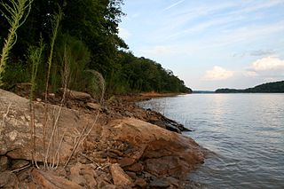
Lake Hartwell is a man-made reservoir bordering Georgia and South Carolina and encompassing parts of the Savannah, Tugaloo, and Seneca rivers. Lake Hartwell is one of the Southeastern United States' largest recreation lakes. The lake was created by the construction of the Hartwell Dam, completed in 1962 and located on the Savannah River seven miles (11 km) below the point at which the Tugaloo and Seneca Rivers join to form the Savannah. Extending 49 miles (79 km) up the Tugaloo and 45 miles (72 km) up the Seneca at normal pool elevation, the lake comprises nearly 56,000 acres (230 km2) of water with a shoreline of 962 miles (1,548 km). The entire Hartwell "Project" contains 76,450 acres (309 km2) of land and water. I-85 bisects Hartwell Lake and makes the area easily accessible to visitors.

The Westo were an Iroquoian Native American tribe encountered in what became the Southeastern U.S. by Europeans in the 17th century. They probably spoke an Iroquoian language. The Spanish called these people Chichimeco, and Virginia colonists may have called the same people Richahecrian. Their first appearance in the historical record is as a powerful tribe in colonial Virginia who had migrated from the mountains into the region around present-day Richmond. Their population provided a force of 700–900 warriors.

The Seneca River is created by the confluence of the Keowee River and Twelvemile Creek in northwestern South Carolina, downriver from Lake Keowee near Clemson. It is now entirely inundated by Lake Hartwell, and forms a 21-mile-long (34 km) arm of the lake. The Seneca River and the Tugaloo River join to form the Savannah River.

<span class="mw-page-title-main">Tugaloo</span> 19th century Cherokee village in northeast Georgia

Tugaloo was a Cherokee town located on the Tugaloo River, at the mouth of Toccoa Creek. It was south of Toccoa and Travelers Rest State Historic Site in present-day Stephens County, Georgia. Cultures of ancient indigenous peoples had occupied this area, and those of the South Appalachian Mississippian culture built a platform mound and village here. It was an administrative and ceremonial center for them.

Georgia Power is an electric utility headquartered in Atlanta, Georgia, United States. It was established as the Georgia Railway and Power Company and began operations in 1902 running streetcars in Atlanta as a successor to the Atlanta Consolidated Street Railway Company.

<span class="mw-page-title-main">Savannah Town, South Carolina</span>

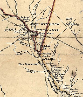
Savannah Town, South Carolina is a defunct settlement that was located in the colonial years on the Savannah River below the Fall Line in present-day Aiken County. In the 1670s the Westo had a village here, but they were displaced by the Savannah in a trade war, and it became known by 1685 as Savannah Town. The English colony had traders who did a lucrative business in dressed skins with the Savannah Shawnee. Fortified as a frontier post, the settlement developed and ferry service was established across the river. The town was gradually overtaken by its competitor of Augusta, Georgia, established in 1735 five miles upriver and closer to Indian settlements. Traders here intercepted commerce, sending it to their port of Savannah on the coast. By 1740 Savannah Town was declining, and by 1765 the village was abandoned and the fort closed.

Henry Woodward, was a Barbados-born merchant and colonist who was one of the first white settlers in the Carolinas. He established relationships with many Native American Tribes in the American southeast. He initiated trade, primarily in deerskins and slaves, with many Indian towns and tribes.

Lake Yonah is a lake on the Tugaloo River, separating Georgia and South Carolina.

<span class="mw-page-title-main">Northeast Georgia</span> Region of Georgia in the United States

Northeast Georgia is a region of Georgia in the United States. The northern part is also in the North Georgia mountains or Georgia mountain region, while the southern part is still hilly but much flatter in topography. Northeast Georgia is also served by the Asheville/Spartanburg/Greenville/Anderson market.

The Chauga River is a 31.3-mile-long (50.4 km) tributary of the Tugaloo River in Oconee County, South Carolina.

<span class="mw-page-title-main">J. Strom Thurmond Dam</span> Dam in South Carolina, USA

J. Strom Thurmond Dam, also known in Georgia as Clarks Hill Dam, is a concrete-gravity and embankment dam located 22 miles (35 km) north of Augusta, Georgia on the Savannah River at the border of South Carolina and Georgia, creating Lake Strom Thurmond. U.S. Route 221 cross it. The dam was built by the U.S. Army Corps of Engineers between 1946 and 1954 for the purposes of flood control, hydroelectricity and downstream navigation. The concrete structure of the dam spans 1,096 feet (334 m) and rises 204 feet (62 m) above the riverbed, housing a power plant with an installed 380 MW capacity. The Dam has prevented over $3.1 million in estimated flood damage annually and also provides recreation, water quality, water supply, along with fish and wildlife management.

<span class="mw-page-title-main">Horse Creek Valley</span>

Horse Creek Valley is a geographic area along Horse Creek, a tributary of the Savannah River. It lies within present-day Aiken County, South Carolina. The area is alternately referred to as "Midland Valley". Rising near Vaucluse, South Carolina, Horse Creek enters the Savannah two miles downstream of downtown Augusta, Georgia. Other communities along Horse Creek include Graniteville, Warrenville, Gloverville, Langley, Burnettown, Bath, and Clearwater. While Horse Creek itself is rather insignificant, its potential for water power led to early examples of Southern industrialization, including a textile mill at Vaucluse (1830) and William Gregg's Graniteville Mill (1845). The textile industry continued to play a primary role until the Graniteville Train Derailment and final closure of the Graniteville Mill in 2006.

References