Candler County, Georgia

Last updated

Candler County
Courthouse of Candler County, Georgia.jpg
Map of Georgia highlighting Candler County.svg
Location within the U.S. state of Georgia
Georgia in United States.svg
Georgia's location within the U.S.
Coordinates: 32°24′N82°04′W / 32.4°N 82.07°W / 32.4; -82.07
CountryFlag of the United States.svg United States
StateFlag of Georgia (U.S. state).svg  Georgia
Founded1914;110 years ago (1914)
Named for Allen D. Candler
Seat Metter
Largest cityMetter
Area
  Total249 sq mi (640 km2)
  Land243 sq mi (630 km2)
  Water5.8 sq mi (15 km2)  2.3%
Population
 (2020)
  Total10,981
  Density45/sq mi (17/km2)
Time zone UTC−5 (Eastern)
  Summer (DST) UTC−4 (EDT)
Congressional district 12th
Website metter-candler.com

Candler County is a county located in the southeastern part of the U.S. state of Georgia. As of the 2020 census, the population was 10,981. [1] The county seat is Metter. [2] The county was founded in 1914 and named for Allen D. Candler, the 56th governor of Georgia. [3]

Contents

Geography

According to the U.S. Census Bureau, the county has a total area of 249 square miles (640 km2), of which 243 square miles (630 km2) is land and 5.8 square miles (15 km2) (2.3%) is water. [4]

The majority of Candler County is located in the Canoochee River sub-basin of the Ogeechee River basin. The western edge of the county, west of State Route 57, is located in the Ohoopee River sub-basin of the Altamaha River basin. [5]

Major highways

Adjacent counties

Communities

City

Town

Demographics

Historical population
CensusPop.Note
1920 9,228
1930 8,991−2.6%
1940 9,1031.2%
1950 8,063−11.4%
1960 6,672−17.3%
1970 6,412−3.9%
1980 7,51817.2%
1990 7,7443.0%
2000 9,57723.7%
2010 10,99814.8%
2020 10,981−0.2%
2023 (est.)11,059 [6] 0.7%
U.S. Decennial Census [7]
1790-1880 [8] 1890-1910 [9]
1920-1930 [10] 1930-1940 [11]
1940-1950 [12] 1960-1980 [13]
1980-2000 [14] 2010 [15]
Candler County racial composition as of 2020 [16]
RaceNum.Perc.
White (non-Hispanic)6,56759.8%
Black or African American (non-Hispanic)2,68124.41%
Native American 190.17%
Asian 630.57%
Pacific Islander 30.03%
Other/Mixed 2702.46%
Hispanic or Latino 1,37812.55%

As of the 2020 United States census, there were 10,981 people, 4,013 households, and 2,775 families residing in the county.

Education

Politics

United States presidential election results for Candler County, Georgia [17]
Year Republican Democratic Third party
No.%No.%No.%
2020 3,13370.71%1,26928.64%290.65%
2016 2,66470.79%1,02627.27%731.94%
2012 2,34466.38%1,15732.77%300.85%
2008 2,28664.91%1,20934.33%270.77%
2004 2,04864.91%1,09634.74%110.35%
2000 1,64360.36%1,05338.68%260.96%
1996 1,13145.22%1,09743.86%27310.92%
1992 1,01436.81%1,19243.27%54919.93%
1988 1,26158.82%87740.90%60.28%
1984 1,49759.62%1,01440.38%00.00%
1980 1,03042.54%1,35856.09%331.36%
1976 64631.76%1,38868.24%00.00%
1972 1,42785.71%23814.29%00.00%
1968 55219.98%58721.25%1,62458.78%
1964 1,71068.26%79531.74%00.00%
1960 43331.47%94368.53%00.00%
1956 30823.62%99676.38%00.00%
1952 42222.57%1,44877.43%00.00%
1948 12512.41%58958.49%29329.10%
1944 13817.45%65382.55%00.00%
1940 637.75%74892.00%20.25%
1936 807.44%99292.28%30.28%
1932 132.65%47697.14%10.20%
1928 13324.45%41175.55%00.00%
1924 145.20%24189.59%145.20%
1920 689.18%67390.82%00.00%
1916 285.96%44294.04%00.00%
1912 10418.81%44380.11%61.08%

See also

Related Research Articles

<span class="mw-page-title-main">Worth County, Georgia</span> County in Georgia, United States

Worth County is a county located in the south-central portion of the U.S. state of Georgia. As of the 2020 census, the population was 20,784. The county seat is Sylvester. Worth County is included in the Albany, GA metropolitan statistical area.

<span class="mw-page-title-main">Wheeler County, Georgia</span> County in Georgia, United States

Wheeler County is a county located in the central portion of the U.S. state of Georgia. As of the 2020 census, the population was 7,471. The county seat is Alamo. The county is one of the most impoverished counties in the nation. The American Community Survey's 2009–2013 average reports that the county's per-capita income of $8,948 makes it the poorest county in the United States by this metric. The measurement however is misleading as Wheeler County is the site of Wheeler Correctional Facility, a large prison with a capacity of 2,874 prisoners, about 40 percent of the county's total population. Most prisoners have little income. The prison was opened in 1998 and the prison population may also account for the increased population of the county in the early 2000s.

<span class="mw-page-title-main">Washington County, Georgia</span> County in Georgia, United States

Washington County is a county located in the U.S. state of Georgia. As of the 2020 census, the population was 19,988. The county seat is Sandersville. The county was established on February 25, 1784. It was named for Revolutionary War general George Washington.

<span class="mw-page-title-main">Upson County, Georgia</span> County in Georgia, United States

Upson County is a county located in the west central Piedmont portion of the U.S. state of Georgia. As of the 2020 census, the population was 27,700. The county seat is Thomaston. The county was created on December 15, 1824.

<span class="mw-page-title-main">Turner County, Georgia</span> County in Georgia, United States

Turner County is a county located in the south central portion of the U.S. state of Georgia. As of the 2020 census, the population was 9,006. The county seat is Ashburn. The county was created on August 18, 1905, and named for Henry Gray Turner, U.S. representative and Georgia state Supreme Court justice.

<span class="mw-page-title-main">Treutlen County, Georgia</span> County in Georgia, United States

Treutlen County is a county located in the east central. & Magnolia midlands portion of the U.S. state of Georgia. As of the 2020 census, the population was 6,406. The county seat is Soperton. It is host to the Million Pines Arts and Crafts Festival which occurs during the first weekend in November.

<span class="mw-page-title-main">Toombs County, Georgia</span> County in Georgia, United States

Toombs County is a county located in the east central portion of the U.S. state of Georgia. As of the 2020 census, the population was 27,030. The county seat is Lyons and the largest city is Vidalia. The county was created on August 18, 1905.

<span class="mw-page-title-main">Pierce County, Georgia</span> County in Georgia, United States

Pierce County is a county located in the southeastern part of the U.S. state of Georgia. As of the 2020 census, the population was 19,716. The county seat is Blackshear.

<span class="mw-page-title-main">McDuffie County, Georgia</span> County in Georgia, United States

McDuffie County is a county located in the U.S. state of Georgia. As of the 2020 census, the population was 21,632. The county seat is Thomson. The county was created on October 18, 1870 and named after the South Carolina governor and senator George McDuffie.

<span class="mw-page-title-main">Marion County, Georgia</span> County in Georgia, United States

Marion County is a county located in the west central portion of the U.S. state of Georgia. As of the 2020 census, the county had a population of 7,498. The county seat is Buena Vista. The county was created on December 14, 1827. The county was named for General Francis Marion of South Carolina.

<span class="mw-page-title-main">Lee County, Georgia</span> County in Georgia, United States

Lee County is a county located in the U.S. state of Georgia. As of the 2020 census, the population was 33,163. The county was established in 1825 and its county seat is Leesburg. Lee County is included in the Albany, GA metropolitan statistical area.

<span class="mw-page-title-main">Laurens County, Georgia</span> County in Georgia, United States

Laurens County is a county located in the central part of the U.S. state of Georgia. As of the 2020 census, the population was 49,570, up from 48,434 in 2010. The county seat is Dublin. The county was founded on December 10, 1807, and named after Lieutenant Colonel John Laurens, an American soldier and statesman from South Carolina during the American Revolutionary War.

<span class="mw-page-title-main">Johnson County, Georgia</span> County in Georgia, United States

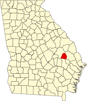
Johnson County is a county located along the oconee River in the U.S. state of Georgia. As of the 2020 census, the population was 9,189. The county seat is Wrightsville. Johnson County is part of the Dublin, Georgia, micropolitan statistical area.

<span class="mw-page-title-main">Jefferson County, Georgia</span> County in Georgia, United States

Jefferson County is a county located in the U.S. state of Georgia. As of the 2020 census, the population was 15,709. The county seat and largest city is Louisville. The county was created on February 20, 1796, and named for Thomas Jefferson, the main author of the Declaration of Independence who became the third president of the United States.

<span class="mw-page-title-main">Glascock County, Georgia</span> County in Georgia, United States

Glascock County is a county located in the U.S. state of Georgia. As of the 2020 census, the population was 2,884, making it the fourth-least populous county in Georgia. The county seat is Gibson. The county was created on December 19, 1857.

<span class="mw-page-title-main">Emanuel County, Georgia</span> County in Georgia, United States

Emanuel County is a county located in the magnolia midlands portion of the U.S. state of Georgia. As of the 2020 census, the population was 22,768. The county seat is Swainsboro.

<span class="mw-page-title-main">Dougherty County, Georgia</span> County in Georgia, United States

Dougherty County is located in the southwestern portion of the U.S. state of Georgia. As of the 2020 census, the population was 85,790. The county seat and sole incorporated city is Albany.

<span class="mw-page-title-main">Clinch County, Georgia</span> County in Georgia, United States

Clinch County is a county located in the southeastern part of the U.S. state of Georgia. As of the 2020 census, the population was 6,749. The county seat is Homerville. The county was created on February 14, 1850, named in honor of Duncan Lamont Clinch.

<span class="mw-page-title-main">Charlton County, Georgia</span> County in Georgia, United States

Charlton County is the southernmost county of the U.S. state of Georgia, located in the southeastern part of the state. As of the 2020 census, the population was 12,518. The county seat is Folkston.

<span class="mw-page-title-main">Bulloch County, Georgia</span> County in Georgia, United States

Bulloch County is a county located in the southeastern part of the U.S. state of Georgia. As of the 2020 census, the population was 81,099, up from 70,217 in 2010. The county seat is Statesboro. With Evans County, Bulloch forms part of the Statesboro micropolitan statistical area, a component of the Savannah–Hinesville–Statesboro combined statistical area.

References

  1. "Census - Geography Profile: Candler County, Georgia". United States Census Bureau . Retrieved December 26, 2022.
  2. "Find a County". National Association of Counties. Archived from the original on May 31, 2011. Retrieved June 7, 2011.
  3. "Candler County". Georgia.gov. Archived from the original on June 14, 2012. Retrieved March 19, 2018.
  4. "US Gazetteer files: 2010, 2000, and 1990". United States Census Bureau. February 12, 2011. Retrieved April 23, 2011.
  5. "Georgia Soil and Water Conservation Commission Interactive Mapping Experience". Georgia Soil and Water Conservation Commission. Archived from the original on October 3, 2018. Retrieved November 22, 2015.
  6. "Annual Estimates of the Resident Population for Counties: April 1, 2020 to July 1, 2023". United States Census Bureau. Retrieved March 31, 2024.
  7. "Decennial Census of Population and Housing by Decades". US Census Bureau.
  8. "1880 Census Population by Counties 1790-1800" (PDF). US Census Bureau . 1880.
  9. "1910 Census of Population - Georgia" (PDF). US Census Bureau . 1910.
  10. "1930 Census of Population - Georgia" (PDF). US Census Bureau . 1930.
  11. "1940 Census of Population - Georgia" (PDF). US Census Bureau . 1940.
  12. "1950 Census of Population - Georgia -" (PDF). US Census Bureau . 1950.
  13. "1980 Census of Population - Number of Inhabitants - Georgia" (PDF). US Census Bureau . 1980.
  14. "2000 Census of Population - Population and Housing Unit Counts - Georgia" (PDF). US Census Bureau . 2000.
  15. "State & County QuickFacts". United States Census Bureau. Archived from the original on June 7, 2011. Retrieved February 15, 2014.
  16. "Explore Census Data". data.census.gov. Retrieved December 18, 2021.
  17. Leip, David. "Dave Leip's Atlas of U.S. Presidential Elections". uselectionatlas.org. Retrieved March 19, 2018.

32°24′N82°04′W / 32.40°N 82.07°W / 32.40; -82.07