Banks County, Georgia

Last updated

Banks County
Courthouse of Banks County, Georgia.jpg
Banks County courthouse in Homer
Seal of Banks County, Georgia.png
Map of Georgia highlighting Banks County.svg
Location within the U.S. state of Georgia
Georgia in United States.svg
Georgia's location within the U.S.
Coordinates: 34°21′N83°30′W / 34.35°N 83.5°W / 34.35; -83.5
CountryFlag of the United States.svg United States
StateFlag of Georgia (U.S. state).svg  Georgia
FoundedFebruary 1, 1859;165 years ago (1859-02-01)
Named for Richard Banks
Seat Homer
Largest city Baldwin
Area
  Total234 sq mi (610 km2)
  Land232 sq mi (600 km2)
  Water1.8 sq mi (5 km2)  0.8%
Population
 (2020)
  Total18,035
  Density79/sq mi (31/km2)
Time zone UTC−5 (Eastern)
  Summer (DST) UTC−4 (EDT)
Congressional district 9th
Website www.bankscountyga.org

Banks County is a county located in the northeastern part of the U.S. state of Georgia. As of the 2020 census, the population was 18,035, [1] down from 18,395 in 2010. [2] The county seat is Homer. [3] The Old Banks County Courthouse is located in Homer and listed on the National Register of Historic Places. A new county courthouse was constructed adjacent to the old one in 1983.

Contents

History

The law to establish Banks County was passed by the Georgia General Assembly on December 11, 1858. [4] It was named for Dr. Richard E. Banks. [5] The legislation called for the creation of Banks County on February 1, 1859, from Franklin and Habersham counties.

Ty Cobb, a Baseball Hall of Famer, was born in Banks County in 1886 in an area of the county known as The Narrows - a small farming community consisting of fewer than 100 people. The area and birthplace are on State Highway 105 in the northern part of the county near the Broad River. The legal organ for the county is The Banks County News, a member of Mainstreet News, Inc. One of the county's oldest church sites is the Hebron Presbyterian Church, established in 1796. Banks County is the home of the Atlanta Dragway, located near Banks Crossing. Banks County is also known for being the home of the former world's largest Easter egg hunt. (The 50th annual egg hunt in 2009 was the last in the series.)

Geography

According to the U.S. Census Bureau, the county has a total area of 234 square miles (610 km2), of which 232 square miles (600 km2) is land and 1.8 square miles (4.7 km2) (0.8%) is water. [6] Banks County is entirely located in the Broad River sub-basin of the Savannah River basin. [7]

Major highways

Adjacent counties

National protected area

Demographics

Historical population
CensusPop.Note
1860 4,707
1870 4,9735.7%
1880 7,33747.5%
1890 8,56216.7%
1900 10,54523.2%
1910 11,2446.6%
1920 11,8145.1%
1930 9,703−17.9%
1940 8,733−10.0%
1950 6,935−20.6%
1960 6,497−6.3%
1970 6,8335.2%
1980 8,70227.4%
1990 10,30818.5%
2000 14,42239.9%
2010 18,39527.5%
2020 18,035−2.0%
2023 (est.)19,789 [8] 9.7%
U.S. Decennial Census [9]
1790-1880 [10] 1890-1910 [11]
1920-1930 [12] 1930-1940 [13]
1940-1950 [14] 1960-1980 [15]
1980-2000 [16] 2010 [2]
2020 [1]

2020 census

Banks County Racial Composition [17]
RaceNum.Perc.
White 15,57886.38%
Black or African American 3942.18%
Native American 540.3%
Asian 1891.05%
Pacific Islander 80.04%
Other/Mixed 6483.59%
Hispanic or Latino 1,1646.45%

As of the 2020 United States Census, there were 18,035 people, 6,740 households, and 4,875 families residing in the county.

2010 census

As of the 2010 United States census, there were 18,395 people, 6,700 households, and 5,100 families living in the county. [18] The population density was 79.3 inhabitants per square mile (30.6/km2). There were 7,595 housing units at an average density of 32.7 units per square mile (12.6 units/km2). [19] The racial makeup of the county was 91.7% white, 2.3% black or African American, 0.9% Asian, 0.3% American Indian, 3.3% from other races, and 1.4% from two or more races. Those of Hispanic or Latino origin made up 5.7% of the population. [18] In terms of ancestry, 18.7% were American, 8.5% were Irish, and 8.5% were English. [20]

Of the 6,700 households, 36.8% had children under the age of 18 living with them, 60.6% were married couples living together, 10.2% had a female householder with no husband present, 23.9% were non-families, and 20.2% of all households were made up of individuals. The average household size was 2.75 and the average family size was 3.14. The median age was 38.4 years. [18]

The median income for a household in the county was $40,455 and the median income for a family was $48,606. Males had a median income of $41,444 versus $26,998 for females. The per capita income for the county was $19,497. About 13.0% of families and 15.9% of the population were below the poverty line, including 15.9% of those under age 18 and 16.6% of those age 65 or over. [21]

2000 census

As of the census [22] of 2000, there were 14,422 people, 5,364 households, and 4,162 families living in the county. The population density was 62 people per square mile (24 people/km2). There were 5,808 housing units at an average density of 25 units per square mile (9.7 units/km2). The racial makeup of the county was 93.16% White, 3.22% Black or African American, 0.30% Native American, 0.60% Asian, 0.06% Pacific Islander, 1.96% from other races, and 0.71% from two or more races. 3.42% of the population were Hispanic or Latino of any race.

There were 5,364 households, out of which 35.60% had children under the age of 18 living with them, 65.40% were married couples living together, 7.90% had a female householder with no husband present, and 22.40% were non-families. 19.20% of all households were made up of individuals, and 7.70% had someone living alone who was 65 years of age or older. The average household size was 2.69 and the average family size was 3.06.

In the county, the population was spread out, with 26.20% under the age of 18, 8.90% from 18 to 24, 30.70% from 25 to 44, 23.70% from 45 to 64, and 10.50% who were 65 years of age or older. The median age was 35 years. For every 100 females there were 102.00 males. For every 100 females age 18 and over, there were 99.70 males.

The median income for a household in the county was $38,523, and the median income for a family was $43,136. Males had a median income of $29,986 versus $21,698 for females. The per capita income for the county was $17,424. About 9.80% of families and 12.50% of the population were below the poverty line, including 14.00% of those under age 18 and 16.30% of those age 65 or over.

Education

The Banks County School District is a public school district that services Banks County, and is based in Homer. There are four schools in the district, which educate 2,788 students in kindergarten through 12th grade. [23]

Communities

Cities

Towns

Unincorporated communities

Politics

United States presidential election results for Banks County, Georgia [24]
Year Republican Democratic Third party
No.%No.%No.%
2020 7,79588.53%93210.58%780.89%
2016 6,13487.94%6849.81%1572.25%
2012 5,35486.30%78012.57%701.13%
2008 5,12081.93%1,02716.43%1021.63%
2004 4,41078.86%1,14920.55%330.59%
2000 3,20270.64%1,22026.91%1112.45%
1996 1,92547.23%1,53637.68%61515.09%
1992 1,55142.25%1,53041.68%59016.07%
1988 1,59061.58%98438.11%80.31%
1984 1,54959.30%1,06340.70%00.00%
1980 74626.01%2,09172.91%311.08%
1976 33012.15%2,38787.85%00.00%
1972 1,33678.96%35621.04%00.00%
1968 39818.70%29613.91%1,43467.39%
1964 54830.34%1,25869.66%00.00%
1960 22115.89%1,17084.11%00.00%
1956 18715.90%98984.10%00.00%
1952 20413.98%1,25586.02%00.00%
1948 386.35%53389.13%274.52%
1944 12520.19%49079.16%40.65%
1940 16419.57%66879.71%60.72%
1936 18122.02%64177.98%00.00%
1932 584.26%1,28394.27%201.47%
1928 36346.24%42253.76%00.00%
1924 8621.88%29174.05%164.07%
1920 34241.66%47958.34%00.00%
1916 1189.57%98980.21%12610.22%
1912 8336.89%13359.11%94.00%

See also

Related Research Articles

<span class="mw-page-title-main">Clay County, Georgia</span> County in Georgia, United States

Clay County is a county located in the southwestern part of the U.S. state of Georgia. As of the 2020 census, the population was 2,848, making it the fourth-least populous county in Georgia. The county seat is Fort Gaines.

<span class="mw-page-title-main">Pershing County, Nevada</span> County in Nevada, United States

Pershing County is a county in the U.S. state of Nevada. As of the 2020 census, the population was 6,650. Its county seat is Lovelock. The county was named after army general John J. Pershing (1860–1948). It was formed from Humboldt County in 1919, and the last county to be established in Nevada. The Black Rock Desert, location for the annual Burning Man event, is partially in the county. The county is listed as Nevada Historical Marker 17. The marker is at the courthouse in Lovelock.

<span class="mw-page-title-main">White County, Georgia</span> County in Georgia, United States

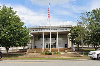
White County is a county located in the northeastern part of the U.S. state of Georgia. As of the 2020 census, the population was 28,003. The county seat is Cleveland. The county was created on December 22, 1857, formerly a part of Habersham County and most likely was named for Newton County Representative David T. White, who helped a Habersham representative successfully attain passage of an act creating the new county.

<span class="mw-page-title-main">Towns County, Georgia</span> County in Georgia, United States

Towns County is a county located in the northeastern part of the U.S. state of Georgia. As of the 2020 census, the population was 12,493. Its county seat is Hiawassee. The county was created on March 6, 1856, and named for lawyer, legislator, and politician George W. Towns.

<span class="mw-page-title-main">Stephens County, Georgia</span> County in Georgia, United States

Stephens County is a county in the northeastern part of the U.S. state of Georgia, in the Piedmont and near the foothills of the Blue Ridge Mountains. It is bounded by the Tugaloo River and Lake Hartwell on the east. As of the 2020 census, the population was 26,784. The county seat is Toccoa.

<span class="mw-page-title-main">Polk County, Georgia</span> County in Georgia, United States

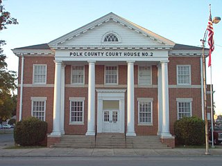
Polk County is a county located in the northwestern part of the U.S. state of Georgia. As of the 2020 census, the population was 42,853. The county seat is Cedartown. The county was created on December 20, 1851, by an act of the Georgia General Assembly and named after James K. Polk, the eleventh President of the United States.

<span class="mw-page-title-main">Hart County, Georgia</span> County in Georgia, United States

Hart County is a county located in the northeastern part of the U.S. state of Georgia. As of the 2020 census, the population was 25,828. The county seat is Hartwell.

<span class="mw-page-title-main">Haralson County, Georgia</span> County in Georgia, United States

Haralson County is a county located in the northwestern part of the U.S. state of Georgia. As of the 2020 census, the population was 29,919, up from 28,780 in 2010. The county seat is Buchanan. The county was created on January 26, 1856, and was named for Hugh A. Haralson, a former Georgia congressman.

<span class="mw-page-title-main">Hall County, Georgia</span> County in Georgia, United States

Hall County is a county located in the northeast portion of the U.S. state of Georgia. As of the 2020 census, the population was 203,136, up from 179,684 at the 2010 census. The county seat is Gainesville. The entirety of Hall County comprises the Gainesville, Georgia, Metropolitan Statistical Area, which is also part of the Atlanta-Athens-Clarke County-Sandy Springs, Combined Statistical Area.

<span class="mw-page-title-main">Habersham County, Georgia</span> County in Georgia, United States

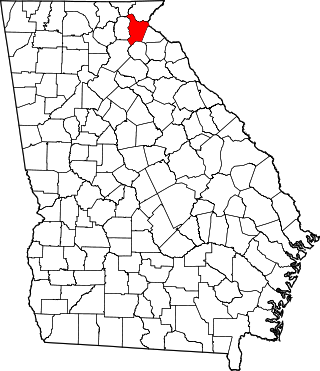
Habersham County is a county located in the northeastern part of the U.S. state of Georgia. As of the 2020 census, the population was 46,031. The county seat is Clarkesville. The county was created on December 15, 1818, and named for Colonel Joseph Habersham of the Continental Army in the Revolutionary War.

<span class="mw-page-title-main">Franklin County, Georgia</span> County in Georgia, United States

Franklin County is a county located in the northeastern part of the U.S. state of Georgia. As of the 2020 census, the population was 23,424. The county seat is Carnesville. On February 25, 1784, Franklin and Washington became Georgia's eighth and ninth counties, with Franklin named in honor of patriot Benjamin Franklin.

<span class="mw-page-title-main">Floyd County, Georgia</span> County in Georgia, United States

Floyd County is a county located in the northwestern part of the U.S. state of Georgia. As of the 2020 United States Census, the population was 98,584. The county seat is Rome.

<span class="mw-page-title-main">Catoosa County, Georgia</span> County in Georgia, United States

Catoosa County is a county located in the northwestern part of the U.S. state of Georgia. As of the 2020 census, the population was 67,872. The county seat is Ringgold. The county was created on December 5, 1853. The meaning of the Cherokee language name "Catoosa" is obscure: "Catoosa" may come from the Cherokee words gatusi or gatu'gitse.

<span class="mw-page-title-main">Ben Hill County, Georgia</span> County in Georgia, United States

Ben Hill County is a county located in the U.S. state of Georgia. As of the 2020 census, the population was 17,194. The county seat is Fitzgerald. The county was organized in 1906. It is named after Benjamin Harvey Hill, a former Confederate and United States Senator.

<span class="mw-page-title-main">Alto, Georgia</span> Town in Georgia, United States

Alto is a town in Banks and Habersham counties in the U.S. state of Georgia. As of the 2010 census, the town had a population of 1,172, up from 876 at the 2000 census.

<span class="mw-page-title-main">Baldwin, Georgia</span> City in Georgia, United States

Baldwin is a city in Banks and Habersham counties in the U.S. state of Georgia. As of the 2010 census, the city had a population of 3,279, up from 2,425 at the 2000 census.

<span class="mw-page-title-main">Clarkesville, Georgia</span> City in Georgia, United States

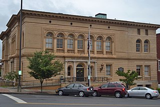
Clarkesville is a city that is the county seat of Habersham County, Georgia, United States. As of the 2020 census, it had a population of 1,911, up from the 2010 census population of 1,733, up from 1,248 at the 2000 census.

<span class="mw-page-title-main">Demorest, Georgia</span> City in Georgia, United States

Demorest is a city in Habersham County, Georgia, United States. The population was 2,022 at the 2020 census, up from 1,823 at the 2010 census, and 1,465 at the 2000 census. It is the home of Piedmont University.

<span class="mw-page-title-main">Mount Airy, Georgia</span> Town in Georgia, United States

Mount Airy is a town in Habersham County, Georgia, United States. The population was 1,284 at the 2010 census, up from 604 at the 2000 census.

<span class="mw-page-title-main">Raoul, Georgia</span> Place in Georgia, United States

Raoul is an unincorporated community and census-designated place (CDP) in Habersham County, Georgia, United States. As of the 2010 census, the CDP had a population of 2,558, up from 1,816 at the 2000 census.

References

  1. 1 2 "QuickFacts: Banks County, Georgia". United States Census Bureau. Retrieved May 5, 2022.
  2. 1 2 "State & County QuickFacts". United States Census Bureau. Retrieved December 26, 2017.
  3. "Find a County". National Association of Counties. Archived from the original on May 31, 2011. Retrieved June 7, 2011.
  4. Krakow, Kenneth K. (1975). Georgia Place-Names: Their History and Origins (PDF). Macon, GA: Winship Press. p. 13. ISBN   0-915430-00-2. Archived (PDF) from the original on September 17, 2003.
  5. Hellmann, Paul T. (May 13, 2013). Historical Gazetteer of the United States. Routledge. p. 233. ISBN   978-1135948597 . Retrieved November 30, 2013.
  6. "US Gazetteer files: 2010, 2000, and 1990". United States Census Bureau. February 12, 2011. Retrieved April 23, 2011.
  7. "Georgia Soil and Water Conservation Commission Interactive Mapping Experience". Georgia Soil and Water Conservation Commission. Archived from the original on October 3, 2018. Retrieved November 18, 2015.
  8. "Annual Estimates of the Resident Population for Counties: April 1, 2020 to July 1, 2023". United States Census Bureau. Retrieved March 31, 2024.
  9. "Decennial Census of Population and Housing by Decades". US Census Bureau.
  10. "1880 Census Population by Counties 1790-1800" (PDF). US Census Bureau . 1880.
  11. "1910 Census of Population - Georgia" (PDF). US Census Bureau . 1910.
  12. "1930 Census of Population - Georgia" (PDF). US Census Bureau . 1930.
  13. "1940 Census of Population - Georgia" (PDF). US Census Bureau . 1940.
  14. "1950 Census of Population - Georgia -" (PDF). US Census Bureau . 1950.
  15. "1980 Census of Population - Number of Inhabitants - Georgia" (PDF). US Census Bureau . 1980.
  16. "2000 Census of Population - Population and Housing Unit Counts - Georgia" (PDF). US Census Bureau . 2000.
  17. "Explore Census Data". data.census.gov. Retrieved December 9, 2021.
  18. 1 2 3 "DP-1 Profile of General Population and Housing Characteristics: 2010 Demographic Profile Data". United States Census Bureau. Archived from the original on February 13, 2020. Retrieved December 27, 2015.
  19. "Population, Housing Units, Area, and Density: 2010 - County". United States Census Bureau. Archived from the original on February 13, 2020. Retrieved December 27, 2015.
  20. "DP02 Selected Social Characteristics in the United States – 2006-2010 American Community Survey 5-Year Estimates". United States Census Bureau. Archived from the original on February 13, 2020. Retrieved December 27, 2015.
  21. "DP03 Selected Economic Characteristics – 2006-2010 American Community Survey 5-Year Estimates". United States Census Bureau. Archived from the original on February 13, 2020. Retrieved December 27, 2015.
  22. "U.S. Census website". United States Census Bureau . Retrieved May 14, 2011.
  23. "Banks County School District". Education.com. Retrieved June 29, 2010.
  24. Leip, David. "Dave Leip's Atlas of U.S. Presidential Elections". uselectionatlas.org. Retrieved March 18, 2018.

34°21′N83°30′W / 34.35°N 83.50°W / 34.35; -83.50