
This article lists notable mountains in the U.S. state of Georgia.
This article lists notable mountains in the U.S. state of Georgia.
The following sortable table lists the 11 highest mountain peaks of Georgia with at least 100 feet (30 m) of topographic prominence. The eleven highest mountains in Georgia are all located in five counties in northeast Georgia. Some of these mountains have true summits or peaks, while others are high points on a ridge. Listings found elsewhere may not necessarily agree because they do not include each of these mountains.


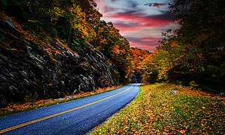
The Appalachian Mountains, often called the Appalachians, are a system of mountains in eastern to northeastern North America. The Appalachians first formed roughly 480 million years ago during the Ordovician Period. They once reached elevations similar to those of the Alps and the Rocky Mountains before experiencing natural erosion. The Appalachian chain is a barrier to east–west travel, as it forms a series of alternating ridgelines and valleys oriented in opposition to most highways and railroads running east–west.
The Blue Ridge Parkway is a National Parkway and All-American Road in the United States, noted for its scenic beauty. The parkway, which is America's longest linear park, runs for 469 miles (755 km) through 29 Virginia and North Carolina counties, linking Shenandoah National Park to Great Smoky Mountains National Park. It runs mostly along the spine of the Blue Ridge, a major mountain chain that is part of the Appalachian Mountains. Its southern terminus is at U.S. Route 441 (US 441) on the boundary between Great Smoky Mountains National Park and the Qualla Boundary of the Eastern Band of Cherokee Indians in North Carolina, from which it travels north to Shenandoah National Park in Virginia. The roadway continues through Shenandoah as Skyline Drive, a similar scenic road which is managed by a different National Park Service unit. Both Skyline Drive and the Virginia portion of the Blue Ridge Parkway are part of Virginia State Route 48 (SR 48), though this designation is not signed.

Dick's Knob or Dicks Knob, with an elevation of 4,620 feet (1,408 m), is the third-highest peak in the State of Georgia if using a 200 ft. prominence rule. It is located in Rabun County, Georgia within the Southern Nantahala Wilderness and is the second-highest mountain in the county.

Hightower Bald, with an elevation of 4,568 feet (1,392 m) is the fourth-highest peak in the US state of Georgia. It is located in Towns County, Georgia at the North Carolina state line and is within the boundaries of the Southern Nantahala Wilderness of the Chattahoochee National Forest.
Rich Mountain, elevation 4,040 feet (1,230 m), is the highest point in the Rich Mountain Wilderness of the Chattahoochee National Forest in Gilmer County, Georgia. It is the second-highest peak in Gilmer County; only Big Bald Mountain is taller, with its summit at 4,081 feet (1,244 m).

Big Bald Mountain is the highest peak in Gilmer County, Georgia, U.S. and is in the Rich Mountain Wilderness, which is administered as a component of the Chattahoochee National Forest.
The Appalachian National Scenic Trail spans fourteen U.S. states during its roughly 2,200 miles (3,500 km)-long journey: Georgia, North Carolina, Tennessee, Virginia, West Virginia, Maryland, Pennsylvania, New Jersey, New York, Connecticut, Massachusetts, Vermont, New Hampshire, and Maine. The southern end is at Springer Mountain, Georgia, and it follows the ridgeline of the Appalachian Mountains, crossing many of its highest peaks and running almost continuously through wilderness before reaching the northern end at Mount Katahdin, Maine.
Rocky Knob is a name used to describe eight different mountain peaks located in the North Georgia mountains that are scattered among four different Georgia counties.

Roan Mountain is a 6,285 ft (1,916 m) mountain straddling the North Carolina/Tennessee border in the Unaka Range of the Southern Appalachian Mountains in the Southeastern United States. The range's highpoint, Roan is clad in a dense stand of Southern Appalachian spruce-fir forest, and includes the world's largest natural rhododendron garden, and the longest stretch of grassy bald in the Appalachian range. The Cherokee National Forest and Pisgah National Forest converge atop the mountain, with Roan Mountain State Park located near its northern base. The Appalachian Trail traverses most of the Roan's crest. The Roan High Knob Shelter is the highest back-country shelter on the entire 2,174-mile (3,499 km) trail.
Thunderhead Mountain is a 5,527-foot (1,685 m) mountain in the west-central part of the Great Smoky Mountains, located in the Southeastern United States. Rising along the border between Tennessee and North Carolina, the mountain dominates the Western Smokies. The Appalachian Trail crosses its summit, making it a popular hiking destination. Rocky Top, a knob on the western part of the mountain's summit ridge, shares its name with a popular Tennessee state song.

Silers Bald is a mountain in the western Great Smoky Mountains, located in the Southeastern United States. Its proximity to Clingmans Dome and its location along the Appalachian Trail make it a popular hiking destination.

Black Balsam Knob, also known as Black Balsam Bald, is in the Pisgah National Forest southwest of Asheville, North Carolina, near milepost 420 on the Blue Ridge Parkway. It is the second highest mountain in the Great Balsam Mountains. The Great Balsams are within the Blue Ridge Mountains, which are part of the Appalachian Mountains. It is the 23rd highest of the 40 mountains in North Carolina over 6000 feet.

The Great Balsam Mountains, or Balsam Mountains, are in the mountain region of western North Carolina, United States. The Great Balsams are a subrange of the Blue Ridge Mountains, which in turn are a part of the Appalachian Mountains. The most famous peak in the Great Balsam range is Cold Mountain, which is the centerpiece of author Charles Frazier's bestselling novel Cold Mountain.

Grassy Mountain is a summit in Murray County, Georgia. At its highest point, the mountain has an elevation of 3,694 feet (1,126 m). It is the second tallest peak in Murray County, if using a 100 feet prominence rule, behind nearby Bald Mountain.

This article comprises three sortable tables of the major mountain peaks of Virginia. This article defines a significant summit as a summit with at least 100 meters of topographic prominence, and a major summit as a summit with at least 500 meters of topographic prominence. All summits in this article have at least 500 meters of topographic prominence. An ultra-prominent summit is a summit with at least 1500 meters of topographic prominence.
| Wikimedia Commons has media related to Mountains of Georgia (U.S. state) . |
