
The Lower Mount Cammerer Trail is an American hiking trail, in the Great Smoky Mountains National Park of Cocke County, Tennessee. The trail ascends Mount Cammerer, leading to a small, untraditional firetower at the summit, from which panoramic views of Cocke County, the main range of the Great Smoky Mountains, and the dominating presence of Mount Guyot are all prominent.

The Great Smoky Mountains National Park is a United States National Park located in a region of the Appalachian Mountains referred to as the Great Smoky Mountains, in a portion of east-central Tennessee and southwest North Carolina. With over 150 hiking trails extending for more than 850 miles (1,370 km), within its boundaries, including a seventy-mile segment of the Appalachian Trail, hiking is the most popular activity in the national park.

Gregory Bald is a mountain in the Great Smoky Mountains. It has an elevation of 4,949 feet above sea level. The mountain's majestic summit makes it a popular hiking destination. Another feature that attracts many visitors are the flame azaleas that bloom over the bald every summer. The azaleas reach peak bloom around mid-to-late June.
Thunderhead Mountain is a 5,527-foot (1,685 m) mountain in the west-central part of the Great Smoky Mountains, located in the southeastern United States. Rising along the border between Tennessee and North Carolina, the mountain dominates the western Smokies. The Appalachian Trail crosses its summit, making it a popular hiking destination. Rocky Top, a knob on the western part of the mountain's summit ridge, shares its name with a popular Tennessee state song.

Chimney Tops is a mountain in the central Great Smoky Mountains in Tennessee. It is 4,724 feet (1,440 m) above sea level. Chimney Tops is a double-capstone knob on the eastern slope of the Sugarland Mountain massif, which stretches north-south across the north-central section of the Smokies. Mount Le Conte resides east of Chimney Tops and Mt. Mingus southeast of Chimney Tops. Thus, while the view from the summit is 360 degrees, Chimney Tops is practically "walled in" on three sides.

Silers Bald is a mountain in the western Great Smoky Mountains, located in the southeastern United States with the Great Smoky Mountains National Park. Its proximity to Clingmans Dome and its location along the Appalachian Trail make it a popular hiking destination.

Mount Kephart is a mountain in the central Great Smoky Mountains, located in the Southeastern United States. The Appalachian Trail crosses the mountain's south slope, making it a destination for thru-hikers. The Jumpoff, a 1,000-foot (300 m) cliff on the northeast side of the mountain, has views of the central and eastern Smokies. A stand of Southern Appalachian spruce-fir forest coats the mountain's upper elevations.
Old Black is a mountain in the Great Smoky Mountains, located in the Southeastern United States. While often overshadowed by Mount Guyot, its higher neighbor to the south, Old Black is the 5th-highest mountain in Tennessee and the 7th-highest in the Great Smoky Mountains National Park. The Appalachian Trail crosses its western slope, connecting the Cosby-area trail system with the heart of the eastern Smokies.

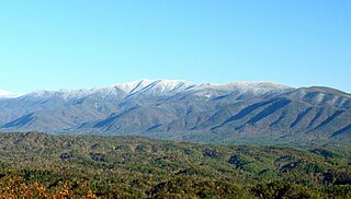
Mount Guyot is a mountain in the Great Smoky Mountains, located in the southeastern United States. At 6,621 feet (2,018 m) in elevation, Guyot is the fourth-highest summit in the Eastern U.S., and the second-highest in the Great Smoky Mountains National Park. While the mountain is remote, the Appalachian Trail crosses its south slope, passing to within 1,000 feet (300 m) of the summit.

The Sugarlands is a valley in Tennessee within the north-central Great Smoky Mountains, located in the southeastern United States. Formerly home to a string of small Appalachian communities, the valley is now the location of the Great Smoky Mountains National Park headquarters and the Sugarlands Visitor Center. Lying just south of Gatlinburg, the Sugarlands is one of the park's most popular access points.
Mount Sequoyah is a mountain in the Great Smoky Mountains, located in the Southeastern United States. It has an elevation of 6,003 feet above sea level. While the Appalachian Trail crosses its summit, Sequoyah is an 11.5-mile (18.5 km) hike from the nearest parking lot, making it one of the most remote places in the Great Smoky Mountains National Park.

Mount Chapman is a mountain in the Great Smoky Mountains, located in the Southeastern United States. It has an elevation of 6,417 feet above sea level. While the mountain is located deep within the Smokies, the Appalachian Trail crosses its eastern slope, coming to within 200 feet (61 m) of the summit. Mount Chapman is among the 10 highest mountains in the Appalachian range, if subpeaks are not included.

The Oconaluftee is the valley of the Oconaluftee River in the Great Smoky Mountains of North Carolina. Formerly the site of a Cherokee village and an Appalachian community, the valley is now North Carolina's main entrance to Great Smoky Mountains National Park.
Greenbrier is a valley in the northern Great Smoky Mountains of Tennessee, located in the southeastern United States. Now a recreational area located within the Great Smoky Mountains National Park, Greenbrier was once home to several Appalachian communities.

The Sugarland Mountain Trail is an American hiking trail, in the Great Smoky Mountains National Park of Sevier County, Tennessee. The trail traverses Sugarland Mountain, a massive ridge running perpendicular to the main crest of the Smokies and effectively dividing the park's north-central section from its northwestern section. Sugarland Mountain is flanked by the deep upper valleys of two of the park's major watersheds— the West Fork of the Little Pigeon River and Little River. The trail passes through several forest types, including deciduous forest at lower elevations, heaths ("hells") along the mountain's backbone formations, and a stand of Southern Appalachian spruce-fir forest in the upper elevations. Occasional breaks in the foliage allow for views of Mount Le Conte and Sevier County to the east and Blanket Mountain and the ridges above Elkmont to the west.

The Meigs Mountain Trail is an American hiking trail in the Great Smoky Mountains National Park of Sevier County, Tennessee. The trail traverses the northern slopes of Meigs Mountain in the northwest section of the park, connecting Jakes Creek in the Elkmont area with Lumber Ridge in the Tremont area. The Meigs Mountain Trail, when joined with the 4.1-mile (6.6 km) Lumber Ridge Trail and the first 0.4 miles (0.64 km) of the Jakes Creek Trail, is part of a 10.5-mile (16.9 km) continuous path connecting the Appalachian Club section of Elkmont with the Great Smoky Mountains Institute at Tremont. In the early 20th century, the logging communities that formed at Elkmont and Tremont branched out across the relatively broad northern slopes of Meigs Mountain. Other than a crude mountain cemetery, the occasional detritus, and a few rock walls, however, very little remains of the mountain's former inhabitants.

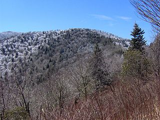
The Snake Den Ridge Trail is an American hiking trail in the Great Smoky Mountains National Park of Cocke County, Tennessee. Winding its way up the backbone-like crest of Snake Den Ridge, the trail connects the Cosby Campground to the Appalachian Trail and provides the quickest access to the high peaks of the Eastern Smokies. The trail passes through three forest types— a mixed deciduous forest at its lower elevations, a substantial stand of heath bald on the more narrow sections of the ridge crest, and an old growth northern-style coniferous forest at its higher elevations.

The Maddron Bald Trail is an American hiking trail in the Great Smoky Mountains National Park of Cocke County, Tennessee. Rising from the outskirts of the Cosby community, the trail ascends Maddron Bald, a 5,212-foot (1,589 m) mountain crowned by one of the park's most substantial heath balds. The trail also provides access to Albright Grove, a patch of old growth hardwood forest that contains some of the oldest and tallest trees in the Smokies. The Maddron Bald Trail's terminus— at its junction with the Snake Den Ridge Trail— is just 0.7 miles (1.1 km) from the Appalachian Trail.

Mount Sterling is a mountain in the Great Smoky Mountains of Haywood County, North Carolina, located in the southeastern United States. It reaches an elevation of 5,842 feet (1,781 m) above sea level. The summit is topped by an abandoned fire tower that overlooks other nearby peaks.

Marks Knob is a mountain in the central Great Smoky Mountains, in the southeastern United States. It has an elevation of 6,169 feet (1,880 m), with 249 feet (76 m) of clean prominence. Its summit is a popular bushwhacking destination and one of the most difficult-to-reach summits of the Southern Sixers.


