Warren County is a county located on the Cumberland Plateau in Middle Tennessee, one of the three Grand Divisions of the U.S. state of Tennessee. As of the 2020 census, the population was 40,953. Its county seat is McMinnville. Warren County comprises the McMinnville, TN Micropolitan Statistical Area.

Cumberland County is a county located in the U.S. state of Tennessee. As of the 2020 census, the population was 61,145. Its county seat is Crossville. Cumberland County comprises the Crossville, TN micropolitan statistical area.

Campbell County is a county in the U.S. state of Tennessee. It is located on the state's northern border in East Tennessee. As of the 2020 census, its population was 39,272. Its county seat is Jacksboro. Campbell County is included in the Knoxville metropolitan statistical area.

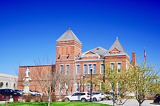
Crossville is a city in and the county seat of Cumberland County, Tennessee, United States. It is part of the Crossville, TN Micropolitan Statistical Area. The population was 12,071 at the 2020 census.

The Cumberland Plateau is the southern part of the Appalachian Plateau in the Appalachian Mountains of the United States. It includes much of eastern Kentucky and Tennessee, and portions of northern Alabama and northwest Georgia. The terms "Allegheny Plateau" and the "Cumberland Plateau" both refer to the dissected plateau lands lying west of the main Appalachian Mountains. The terms stem from historical usage rather than geological difference, so there is no strict dividing line between the two. Two major rivers share the names of the plateaus, with the Allegheny River rising in the Allegheny Plateau and the Cumberland River rising in the Cumberland Plateau in Harlan County, Kentucky.

The Ridge-and-Valley Appalachians, also called the Ridge and Valley Province or the Valley and Ridge Appalachians, are a physiographic province of the larger Appalachian division and are also a belt within the Appalachian Mountains extending from southeastern New York in the north through northwestern New Jersey, westward into Pennsylvania through the Lehigh Valley, and southward into Maryland, West Virginia, Virginia, Kentucky, Tennessee, Georgia, and Alabama. They form a broad arc between the Blue Ridge Mountains and the Appalachian Plateau physiographic province. They are characterized by long, even ridges, with long, continuous valleys in between.

East Tennessee is one of the three Grand Divisions of Tennessee defined in state law. Geographically and socioculturally distinct, it comprises approximately the eastern third of the U.S. state of Tennessee. East Tennessee consists of 33 counties, 30 located within the Eastern Time Zone and three counties in the Central Time Zone, namely Bledsoe, Cumberland, and Marion. East Tennessee is entirely located within the Appalachian Mountains, although the landforms range from densely forested 6,000-foot (1,800 m) mountains to broad river valleys. The region contains the major cities of Knoxville and Chattanooga, Tennessee's third and fourth largest cities, respectively, and the Tri-Cities, the state's sixth largest population center.

The Cumberland Mountains are a mountain range in the southeastern section of the Appalachian Mountains. They are located in western Virginia, southwestern West Virginia, the eastern edges of Kentucky, and eastern middle Tennessee, including the Crab Orchard Mountains. Their highest peak, with an elevation of 4,223 feet (1,287 m) above mean sea level, is High Knob, which is located near Norton, Virginia.

The Caney Fork River is a river that flows through central Tennessee in the United States, draining a substantial portion of the southwestern Cumberland Plateau and southeastern Highland Rim regions. It is a major tributary of the Cumberland River, and is part of the Cumberland, Ohio and Mississippi basins. The river is 143 miles (230 km) long, and its watershed covers 1,771 square miles (4,590 km2) in eleven counties. Monterey, Baxter, Sparta, Smithville, McMinnville, Altamont, Spencer and Gordonsville are among the towns that are at least partially drained by the river.
The Appalachian Plateau is a series of rugged dissected plateaus located on the western side of the Appalachian Mountains. The Appalachian Mountains are a mountain range that run down the Eastern United States. The Appalachian Plateau is the northwestern part of the Appalachian Mountains, stretching from New York to Alabama. The plateau is a second level United States physiographic region, covering parts of the states of New York, Pennsylvania, Ohio, Maryland, West Virginia, Virginia, Kentucky, Tennessee, Alabama, and Georgia.
Catoosa Wildlife Management Area is a large game-management area on the Upper Cumberland Plateau in Morgan, Cumberland and Fentress counties in Tennessee in the United States. It comprises 96,000 acres (332 km2) of wild land administered by the Tennessee Wildlife Resources Agency (TWRA). The Management Area is funded by hunters and fishermen, and is popular with all outdoors enthusiasts, including backpackers, and whitewater rafters. It has many trails for hiking, of which the most notable is the Cumberland Trail. It also has gravel roads and dirt track four-wheel drive roads for motorized exploration. Catoosa ranges from gentle rolling hills to some of the most rugged and extreme terrain in the country. Many rivers and streams have cut deep canyons into the Cumberland Plateau and Cumberland Mountains of the Management area allowing for beautiful vistas.

Cumberland Mountain State Park is a state park in Cumberland County, Tennessee, in the southeastern United States. The park consists of 1,720 acres (7.0 km2) situated around Byrd Lake, a man-made lake created by the impoundment of Byrd Creek in the 1930s. The park is set amidst an environmental microcosm of the Cumberland Plateau and provides numerous recreational activities, including an 18-hole Bear Trace golf course.

The Tennessee Valley Divide is the boundary of the drainage basin of the Tennessee River and its tributaries.
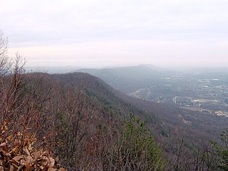
Walden Ridge is a mountain ridge and escarpment located in Tennessee, in the United States. It marks the eastern edge of the Cumberland Plateau and is generally considered part of it. Walden Ridge is about 74 miles (119 km) long, running generally north-south. Its highest point is at Hinch Mountain, which reaches 3,048 feet (929 m) above sea level. Sometimes Walden Ridge is called the Cumberland Escarpment.
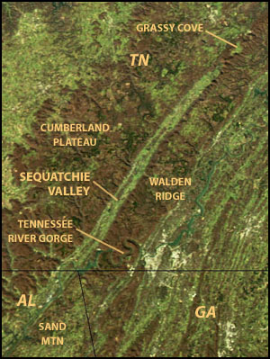
Sequatchie Valley is a relatively long and narrow valley in the U.S. state of Tennessee and, in some definitions, Alabama. It is generally considered to be part of the Cumberland Plateau region of the Appalachian Mountains; it was probably formed by erosion of a compression anticline, rather than rifting process as had been formerly theorized.
Gunters Mountain is a plateau-type summit in the U.S. state of Alabama. Part of the Cumberland Plateau, Gunters Mountain separates the Cumberland Plateau from the valley of the Tennessee River.
The Cumberland dusky salamander is a species of salamander in the family of lungless salamanders, Plethodontidae. It is endemic to the United States. Its natural habitats are temperate forests and rivers. This species is threatened by habitat loss.

Scott's Gulf is a canyon situated along the Caney Fork River in White County, Tennessee, in the southeastern United States. The canyon stretches for approximately 18 miles (29 km) as the Caney Fork drops from the top of the Cumberland Plateau down to the eastern Highland Rim. This remote section of the river is home to a wilderness area consisting of a largely undisturbed deciduous forest, numerous waterfalls, caves and other geological formations, and Class IV and Class V whitewater rapids.
The U.S. state of Tennessee is geographically diverse, with varying terrains and several distinct physiographic regions. Its landforms range from the Blue Ridge Mountains in the eastern part of the state to flat and fertile plains along the Mississippi River. The state is geographically, legally, culturally, and economically divided into three Grand Divisions: East Tennessee, Middle Tennessee, and West Tennessee.
