
Bays Mountain is a ridge of the Ridge-and-Valley Appalachians, located in East Tennessee. It runs southwest to northeast, from just south of Knoxville to Kingsport.
Bays Mountain is a ridge of the Ridge-and-Valley Appalachians, located in East Tennessee. It runs southwest to northeast, from just south of Knoxville to Kingsport.
The southern segment of Bays Mountain is relatively low in elevation (up to about 1,300 feet (396.2 m)). In some places it essentially merges with the surrounding plains, especially where it is bisected by the French Broad River and the Nolichucky River. The northern segment of Bays Mountain reaches higher elevations, averaging above 2,000 feet (609.6 m) with peaks reaching up to 3,000 feet (914.4 m). It is not a single ridge but rather a series of closely related ridges, some of which have names of their own (e.g., Fodderstack, Lost, Stone, Browns). The highest peak is Chimneytop Mountain (3,117 feet (950.1 m)), a spur ridge south of the main Bays Mountain ridge.

Bays Mountain runs just south of the Holston River, which flows northeast to southwest. At Kingsport the Holston River curves east and south at the confluence of its three tributary forks that flow from Virginia to the northeast. Bays Mountain ends abruptly at this curve of the Holston River. Kingsport is on the north side of the river, across from the northern terminus of Bays Mountain, where two ridges meet in a "V" with an impounded lake between the ridges.
Bays Mountain is named after two Bays brothers who settled in southwest Virginia in Russell and Scott counties around 1780.
Bays Mountain Park is a 3,550-acre (14.4 km2) nature park located on Bays Mountain in Kingsport. The park includes a planetarium, live native animal displays, a nature center, 19th-century living farm museum and adventure course.
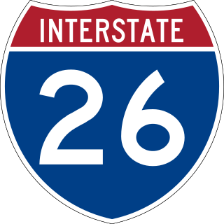
Interstate 26 (I-26) is a main route of the Interstate Highway System in the Southeastern United States. Nominally east–west, as indicated by its even number, I-26 runs from the junction of US Route 11W (US 11W) and US 23 in Kingsport, Tennessee, generally southeastward to US 17 in Charleston, South Carolina. The portion from Mars Hill, North Carolina, east to I-240 in Asheville, North Carolina, has signs indicating FUTURE I-26, because the highway does not yet meet all of the Interstate Highway standards.

Sullivan County is a county located in the U.S. state of Tennessee on its northeast border. As of the 2020 census, the population was 158,163. Its county seat is Blountville.

Elizabethton is a city in, and the county seat of Carter County, Tennessee, United States. Elizabethton is the historical site of the first independent American government located west of both the Eastern Continental Divide and the original Thirteen Colonies.

Kingsport is a city in Sullivan and Hawkins counties in the U.S. state of Tennessee. As of the 2020 census, its population was 55,442. Lying along the Holston River, Kingsport is commonly included in what is known as the Mountain Empire, which spans a portion of southwest Virginia and the mountainous counties in northeastern Tennessee. It is the largest city in the Kingsport–Bristol metropolitan area, which had a population of 307,614 in 2020. The metro area is a component of the larger Tri-Cities region of Tennessee and Virginia, with a population of 508,260 in 2020.

The Blue Ridge Mountains are a physiographic province of the larger Appalachian Highlands range. The mountain range is located in the Eastern United States, and extends 550 miles southwest from southern Pennsylvania through Maryland, West Virginia, Virginia, North Carolina, South Carolina, Tennessee, and Georgia. This province consists of northern and southern physiographic regions, which divide near the Roanoke River gap. To the west of the Blue Ridge, between it and the bulk of the Appalachians, lies the Great Appalachian Valley, bordered on the west by the Ridge and Valley province of the Appalachian range.

Catoctin Mountain, along with the geologically associated Bull Run Mountains, forms the easternmost mountain ridge of the Blue Ridge Mountains, which are in turn a part of the Appalachian Mountains range. The ridge runs northeast–southwest for about 50 miles (80 km) departing from South Mountain near Emmitsburg, Maryland, and running south past Leesburg, Virginia, where it disappears into the Piedmont in a series of low-lying hills near New Baltimore, Virginia. The ridge forms the eastern rampart of the Loudoun and Middletown valleys.

Frozen Head State Park and Natural Area is a state park in Morgan County, Tennessee, in the southeastern United States. The park, situated in the Crab Orchard Mountains between the city of Wartburg and the community of Petros, contains some of the highest mountains in Tennessee west of the Blue Ridge Mountains.

U.S. Route 23 (US 23) is a part of the United States Numbered Highway System that runs from Jacksonville, Florida, to Mackinaw City, Michigan. In Virginia, the U.S. Highway runs 60.80 miles (97.85 km) from the Tennessee state line near Weber City north to the Kentucky state line near Pound. US 23, which is known as Orby Cantrell Highway for most of its course, is a four-lane divided highway that follows Corridor B of the Appalachian Development Highway System through Southwest Virginia. The U.S. Highway serves as the main east–west highway of Scott County and the primary north–south highway of Wise County. US 23 runs concurrently with US 58 from Weber City to Duffield and with US 58 Alternate between Big Stone Gap and the independent city of Norton.

Clinch Mountain is a mountain ridge in the U.S. states of Tennessee and Virginia, lying in the ridge-and-valley section of the Appalachian Mountains. From its southern terminus at Kitts Point, which lies at the intersection of Knox, Union and Grainger counties near Blaine, Tennessee, it runs in a generally east-northeasterly direction to Garden Mountain near Burke's Garden, Virginia. It separates the Clinch River basin to the north and the Holston River basin to the south.
Powell Mountain is a mountain ridge of the Ridge-and-valley Appalachians of the Appalachian Mountains. It is a long and narrow ridge, running northeast to southwest, from about Norton, Virginia, to near Tazewell, Tennessee. It separates the Clinch River basin and the Powell River basin of Powell Valley. It was named for an 18th-century explorer.
The Appalachian National Scenic Trail spans 14 U.S. states over its roughly 2,200 miles (3,500 km): Georgia, North Carolina, Tennessee, Virginia, West Virginia, Maryland, Pennsylvania, New Jersey, New York, Connecticut, Massachusetts, Vermont, New Hampshire, and Maine. The southern end is at Springer Mountain, Georgia, and it follows the ridgeline of the Appalachian Mountains, crossing many of its highest peaks and running almost continuously through wilderness before reaching the northern end at Mount Katahdin, Maine.

Holston Mountain is a mountain ridge in Upper East Tennessee and southwest Virginia, in the United States. It is in the Blue Ridge Mountains part of the Appalachian Mountains. Holston Mountain is a very prominent ridge-type mountain in Tennessee's Ridge and Valley Region, about 28 miles (45 km) long, running from southwest to northeast, covering about 268 square miles (690 km2). Its highest summit is Holston High Point, on which a Federal Aviation Administration (FAA) aircraft navigational beacon is located, at an elevation of 4,280 feet (1,300 m) above mean sea level. The second and third highest points are Rye Patch Knob, at 4,260 feet (1,300 m) above mean sea level and Rich Knob, at 4,240 above mean sea level respectively. The fourth highest point is Holston High Knob where an old dismantled Cherokee National Forest fire tower marks the elevation at 4,136 feet (1,261 m) above mean sea level.
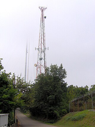
Sharp's Ridge is a steep ridge in Knoxville, Tennessee, north of the city's downtown. A 111-acre (45 ha) area of the 7-mile (11 km) ridge is maintained as Sharp's Ridge Memorial Park, a city park dedicated to the honor of the area's war veterans. The ridge also is the site of a transmitting antenna farm that serves most of Knoxville's broadcasters. The highest ground point on the ridge is an abandoned fire tower located at 1,391 feet (424 m) above mean sea level. The ridge itself averages 200 to 300 feet above the surrounding valley floor, allowing panoramic views of the Great Smoky Mountains and adjacent ranges to the east and the Cumberland Plateau and Cumberland Mountains to the west.

The geography of New York (state) varies widely. Most of New York is dominated by farms, forests, rivers, mountains, and lakes. New York's Adirondack Park is larger than any U.S. National Park in the contiguous United States. Niagara Falls, on the Niagara River as it flows from Lake Erie to Lake Ontario, is a popular attraction. The Hudson River begins near Lake Tear of the Clouds and flows south through the eastern part of the state without draining lakes George or Champlain. Lake George empties at its north end into Lake Champlain, whose northern end extends into Canada, where it drains into the Richelieu River and then the St. Lawrence. Four of New York City's five boroughs are on the three islands at the mouth of the Hudson River: Manhattan Island, Staten Island, and Brooklyn and Queens on Long Island.
The U.S. state of Tennessee is geographically diverse, with varying terrains and several distinct physiographic regions. Its landforms range from the Blue Ridge Mountains in the eastern part of the state to flat and fertile plains along the Mississippi River. The state is geographically, legally, culturally, and economically divided into three Grand Divisions: East Tennessee, Middle Tennessee, and West Tennessee.
U.S. Route 23 (US 23) is a part of the United States Numbered Highway System that travels from Jacksonville, Florida, to Mackinaw City, Michigan. In the U.S. state of Tennessee, the highway travels 57.5 miles (92.5 km) in the northeastern part of the state from the North Carolina state line at Sam's Gap in the Bald Mountains, north to the Virginia state line in Kingsport. With a predominant concurrency with Interstate 26 (I-26), US 23 is a divided four-lane freeway that follows Corridor B of the Appalachian Development Highway System (ADHS) and serves as a major thoroughfare in the Tri-Cities. Although I-26 is technically an east–west route, the highway predominantly travels in a north–south alignment in Tennessee. The route reaches a maximum elevation of 3,760 feet (1,150 m) at the North Carolina state line, which is the highest elevation on the Interstate Highway System east of the Mississippi River.

Buckner Mountain is a tall peak in the North Cascades of Washington state and in the Stephen Mather Wilderness of North Cascades National Park. At 9,114 feet (2,778 m) in elevation it is the highest in Skagit County and one of about ten of Washington's non-volcanic peaks above 9,000 feet high. It is ranked as the 14th highest peak in the state, and the third highest peak in North Cascades National Park.
The Pajarito Mountains is a small mountain range of western Santa Cruz County, Arizona, United States, that extend south into Sonora, Mexico. The range is adjacent the Atascosa Mountains at its north, with both ranges in the center of a north-south sequence of ranges called the Tumacacori Highlands. The Highlands have the Tumacacori Mountains at the north, and south of the U.S.-Mexico border, the Sierra La Esmeralda range. The Tumacacori Highlands are part of a regional conservancy study of "travel corridors" for cats, called Cuatro Gatos, Four Cats, for mountain lions, ocelot, bobcat, and jaguar.
Morrison City is an unincorporated community in Sullivan County, Tennessee, United States. Named for pioneer settler Peter Morison, Morrison City developed with the industrial growth of nearby Kingsport, Tennessee, in the 1930s. Peter Morison, his wife Mary Kirkpatrick Morison, and other relatives, are buried in the Morrison Chapel Cemetery, in the heart of the community. They were awarded a land grant by the state of North Carolina, which controlled the area prior to Tennessee Statehood, in 1780. This was to recognize distinguished service during the Battle of King's Mountain.

The Path Grant Deed is a document regarded as a first step toward the American westward migration across the Appalachian Mountains, resulting from negotiations at Sycamore Shoals in March 1775. The land acquired within the boundaries of the Path Grant allowed Daniel Boone to develop the Wilderness Road free from attack or claims by the Cherokee. The Path Grant was recorded on November 15, 1794, by the Hawkins County, Tennessee registrar in Deed Book #1, pages 147-151
| International | |
|---|---|
| National | |