
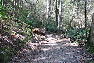
The Appalachian Trail, also called the A.T., is a hiking trail in the Eastern United States, extending almost 2,200 miles (3,540 km) between Springer Mountain in Georgia and Mount Katahdin in Maine, and passing through 14 states. The Appalachian Trail Conservancy claims the Appalachian Trail to be the longest hiking-only trail in the world. More than three million people hike segments of the trail each year.

Brasstown Bald is the highest point in the U.S. state of Georgia. It is located in the northeastern part of the state in the Blue Ridge Mountains on the border between Towns and Union counties south of the city of Hiawassee. The mountain is known to the native Cherokee people as Enotah.

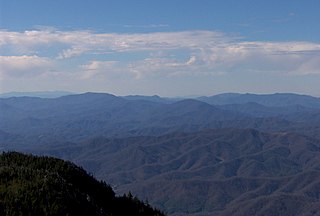
Great Smoky Mountains National Park is an American national park in the southeastern United States, with parts in North Carolina and Tennessee. The park straddles the ridgeline of the Great Smoky Mountains, part of the Blue Ridge Mountains, which are a division of the larger Appalachian Mountain chain. The park contains some of the highest mountains in eastern North America, including Clingmans Dome, Mount Guyot, and Mount Le Conte. The border between the two states runs northeast to southwest through the center of the park. The Appalachian Trail passes through the center of the park on its route from Georgia to Maine. With 14.1 million visitors in 2021, the Great Smoky Mountains National Park is the most visited national park in the United States.

The Cherokee National Forest is a United States National Forest located in the U.S. states of Tennessee and North Carolina that was created on June 14, 1920. The forest is maintained and managed by the United States Forest Service. It encompasses an estimated area of 655,598 acres (2,653.11 km2).

Clingmans Dome is a mountain in the Great Smoky Mountains of Tennessee and North Carolina in the Southeastern United States. Its name in Cherokee is Kuwahi or Kuwohi, meaning "mulberry place."
The Unaka Range is a mountain range on the border of Tennessee and North Carolina, in the southeastern United States. It is a subrange of the Appalachian Mountains and is part of the Blue Ridge Mountains physiographic province. The Unakas stretch approximately from the Nolichucky River in the south to the Watauga River in the north.

The Unicoi Mountains are a mountain range rising along the border between Tennessee and North Carolina in the southeastern United States. They are part of the Blue Ridge Mountain Province of the Southern Appalachian Mountains. The Unicois are located immediately south of the Great Smoky Mountains and immediately west of the Cheoah Mountains. Most of the range is protected as a national forest, namely the Cherokee National Forest on the Tennessee side and the Nantahala National Forest on the North Carolina side— although some parts have been designated as wilderness areas and are thus more strictly regulated.

The Cherohala Skyway is a 43-mile (69 km) National Scenic Byway and National Forest Scenic Byway that connects Tellico Plains, Tennessee, to Robbinsville, North Carolina, in the southeastern United States. Its name is a portmanteau of Cherokee and Nantahala, the two national forests through which it passes. Along with multiple vistas and overlooks, the skyway provides easy vehicular access to various protected and recreational areas of the Unicoi Mountains, including the Citico Creek Wilderness, the Bald River Gorge Wilderness, and the remote interior of the Joyce Kilmer Memorial Forest.

Pisgah National Forest is a National Forest in the Appalachian Mountains of western North Carolina. It is administered by the United States Forest Service, part of the United States Department of Agriculture. The Pisgah National Forest is completely contained within the state of North Carolina. The forest is managed together with the other three North Carolina National Forests from common headquarters in Asheville, North Carolina. There are local ranger district offices located in Pisgah Forest, Mars Hill, and Nebo.
The Benton MacKaye Trail or BMT is a footpath nearly 300 miles (480 km) in length in the Appalachian Mountains in the southeastern United States and is blazed by a white diamond, 5″ across by 7″ tall. The hiking trail was created and is maintained by the Benton MacKaye Trail Association, and it is named for Benton MacKaye, the Massachusetts forester and regional planner who first had the idea for the Appalachian Trail in 1921.

The Great Smoky Mountains National Park is a United States National Park located in a region of the Appalachian Mountains referred to as the Great Smoky Mountains, in a portion of east-central Tennessee and southwest North Carolina. With over 150 hiking trails extending for more than 850 miles (1,370 km), within its boundaries, including a seventy-mile segment of the Appalachian Trail, hiking is the most popular activity in the national park.
The Appalachian National Scenic Trail spans 14 U.S. states over its roughly 2,200 miles (3,500 km): Georgia, North Carolina, Tennessee, Virginia, West Virginia, Maryland, Pennsylvania, New Jersey, New York, Connecticut, Massachusetts, Vermont, New Hampshire, and Maine. The southern end is at Springer Mountain, Georgia, and it follows the ridgeline of the Appalachian Mountains, crossing many of its highest peaks and running almost continuously through wilderness before reaching the northern end at Mount Katahdin, Maine.

Roan Mountain is a 6,285 ft (1,916 m) mountain straddling the North Carolina/Tennessee border in the Unaka Range of the Southern Appalachian Mountains in the Southeastern United States. The range's highpoint, Roan is clad in a dense stand of Southern Appalachian spruce-fir forest, and includes the world's largest natural rhododendron garden, and the longest stretch of grassy bald in the Appalachian range. The Roan Highlands also contain the highest quality remaining stretch of Fraser fir forest throughout the tree's entire range. The Cherokee National Forest and Pisgah National Forest converge atop the mountain, with Roan Mountain State Park located near its northern base. The Appalachian Trail traverses most of the Roan's crest. The Roan High Knob Shelter is the highest back-country shelter on the entire 2,174-mile (3,499 km) trail.

Lake James is a large reservoir in the mountains of Western North Carolina which straddles the border between Burke and McDowell Counties. It is named for tobacco tycoon and benefactor of Duke University James Buchanan Duke. The lake, with surface elevation of 1200 ft, lies behind a series of 4 earthen dams. It was created by Duke Power between 1916 and 1923 as a hydro-electric project. It still generates power today and is the uppermost lake on the Catawba River system.

Gregory Bald is a mountain in the Great Smoky Mountains. It has an elevation of 4,949 feet above sea level. The mountain's majestic summit makes it a popular hiking destination. Another feature that attracts many visitors are the flame azaleas that bloom over the bald every summer. The azaleas reach peak bloom around mid-to-late June.

Andrews Bald is a mountain in the Great Smoky Mountains, located in the southeastern United States. It has an elevation of 5,920 feet (1,800 m) above sea level, making it the highest grassy bald in the Great Smoky Mountains National Park. The mountain is one of two grassy balds maintained in the range by the National Park Service. The other is Gregory Bald, in the western Smokies.

In the Appalachian Mountains of the eastern United States, balds are mountain summits or crests covered primarily by thick vegetation of native grasses or shrubs occurring in areas where heavy forest growth would be expected.

Elk Knob State Park is a 4,423-acre (17.90 km2) North Carolina state park in Watauga County, North Carolina, in the United States. Opened in 2003, it is one of North Carolina's newest state parks. Elk Knob State Park was established to preserve the natural state of Elk Knob, the third highest peak in Watauga County. The park is open for year-round recreation and is currently undergoing an expansion of facilities to provide greater recreational opportunities to visitors. Elk Knob State Park is on Meat Camp Road, 5.5 miles (8.9 km) from North Carolina Highway 194, 9.5 miles (15.3 km) north of Boone, in the Blue Ridge Mountains.

The Bald Mountains are a mountain range rising along the border between Tennessee and North Carolina in the southeastern United States. They are part of the Blue Ridge Mountain Province of the Southern Appalachian Mountains. The Bald Mountains stretch from the Pigeon River in the south to the Nolichucky River in the north, and comprise parts of Cocke County, Greene County, and Unicoi County in Tennessee and parts of Madison County and Yancey County in North Carolina. The Great Smoky Mountains border the range to the south, and the Unakas rise opposite the Nolichucky to the north. The range gets its name from the relatively frequent occurrence of grassy balds atop the more prominent summits.

Albert Mountain is a mountain in North Carolina's Nantahala Range of the Appalachian Mountains. The Appalachian Trail goes along its summit, which is around 5,200 feet (1,600 m) high. A fire tower offers views of the Blue Ridge and the Little Tennessee River valley.


