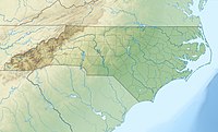
Asheville is a city in, and the county seat of, Buncombe County, North Carolina, United States. Located at the confluence of the French Broad and Swannanoa rivers, it is the largest city in Western North Carolina, and the state's 12th-most populous city. According to 2019 estimates, the city's population was 92,870, up from 83,393 in the 2010 census. It is the principal city in the four-county Asheville metropolitan area, which had a population of 424,858 in 2010, and an estimate population in 2019 of 462,680.

Waynesville is a town in and the county seat of Haywood County, North Carolina, United States. It is the largest town in Haywood County and the largest in western North Carolina west of Asheville. Waynesville is located about 30 miles (50 km) southwest of Asheville between the Great Smoky and Blue Ridge mountains.
Sylva is an incorporated town located in central Jackson County, in the Plott Balsam Mountains of Western North Carolina, United States of America. As of the 2010 census, the town had a total population of 2,588. It is the county seat, having taken over from nearby Webster in 1913.

The Blue River is a tributary of the Colorado River, approximately 65 miles (105 km) long, in the U.S. state of Colorado.

The Laramie River is a tributary of the North Platte River, approximately 280 miles (450 km) long, in the U.S. states of Colorado and Wyoming. The river was named for Jacques La Ramie, a fur trapper who visited the area in the early 19th century. Laramie County, Wyoming, the city of Laramie, and other geographical entities in the region have "Laramie" in their names.

The French Broad River flows 218 miles (351 km) from near the town of Rosman in Transylvania County, North Carolina, into the state of Tennessee. Its confluence with the Holston River at Knoxville is the beginning of the Tennessee River. The river flows through the counties of Transylvania, Buncombe, Henderson, and Madison in North Carolina, and Cocke, Jefferson, Sevier, and Knox in Tennessee. It drains large portions of the Pisgah National Forest and the Cherokee National Forest.

The Catawba River originates in Western North Carolina and flows into South Carolina, where it is known as the Wateree River. The river is approximately 220 miles (350 km) long. It rises in the Appalachian Mountains and drains into the Piedmont, where it has been impounded through a series of reservoirs for flood control and generation of hydroelectricity. The river is named after the Catawba tribe of Native Americans, which lives on its banks. In their language, they call themselves "yeh is-WAH h’reh", meaning "people of the river."

The Pigeon River of Western North Carolina and East Tennessee rises above Canton, North Carolina, is impounded by Walters Dam, enters Tennessee, and flows into the French Broad River, just past Newport, Tennessee. The river traverses the Pisgah National Forest and the Cherokee National Forest, and drains much of the northeastern Great Smoky Mountains National Park.
Interstate 240 (I-240) is a 9.1-mile (14.6 km) long Interstate Highway loop in the U.S. state of North Carolina. It serves as an urban connector for Asheville and runs in a half-circle around the north of the city's downtown district between exits 53B and 46B of Interstate 40. Between those points, I-40 continues in an east–west direction further south of the city, roughly parallel to the Swannanoa and French Broad rivers. The western segment of I-240 is now being co-signed with I-26 as part of a larger project extending I-26 from its former western terminus at I-40/I-240 to U.S. Route 23 (US 23) near Kingsport, Tennessee.
Fawnskin is an unincorporated community in San Bernardino County, California, United States. Its altitude is 6,827 feet (2,081 m). The community has a post office, which was established on May 18, 1918.

Devil's Courthouse is a mountain in the Appalachian Mountains of western North Carolina in the United States of America. The mountain is located at the Western edge of the Pisgah National Forest about 10 miles northwest of Brevard and 28 miles southwest of Asheville. Located at milepost 422.4 of the Blue Ridge Parkway, the Devil's Courthouse has a moderate/strenuous trail climbing a half mile to its peak where panoramic views can be seen.

Roan Mountain is the highpoint of the Unaka Range of the Southern Appalachian Mountains, located in the Southeastern United States. The mountain is clad in a dense stand of Southern Appalachian spruce-fir forest, and includes the world's largest natural rhododendron garden, and the longest stretch of grassy bald in the Appalachian range. The Cherokee National Forest and Pisgah National Forest converge atop the mountain, with Roan Mountain State Park located near its northern base. The Appalachian Trail traverses most of the Roan's crest. The Roan High Knob Shelter is the highest back-country shelter on the entire 2,174-mile (3,499 km) trail.

The Great Craggy Mountains, commonly called the Craggies, are a mountain range in western North Carolina, United States. They are a subrange of the Blue Ridge Mountains and encompass an area of approx. 194 sq mi (503 km²). They are situated in Buncombe County, North Carolina, 14 miles northeast of Asheville. The Black Mountains lie to the northeast, across the upper Cane River valley.
The Sauratown Mountains, which are sometimes called "the mountains away from the mountains", are an isolated mountain range located within Stokes and Surry counties in the U.S. state of North Carolina. The vast majority of the range is located in Stokes County. Although the range occupies only 5% of Stokes County's area, it dominates the county's scenery from almost every direction. The Sauras rise sharply 800 to 1,700 feet above the surrounding terrain. The Sauratown Mountains were named after the "Saura", a Siouan-speaking Native American tribe that lived in the area before European settlers arrived in the early 1700s. The range consists of rugged, heavily forested ridges frequently broken by large quartzite rock cliffs that can be seen for miles. The Sauratown Mountains are known for offering some of the best rock climbing in North Carolina. The highest point in the Sauratown Mountains is Moore's Knob, which rises to 2,579 feet.

Gerton is an unincorporated community and census-designated place (CDP) in Henderson County, North Carolina, United States. As of the 2010 census it had a population of 254. It is part of the Asheville Metropolitan Statistical Area.
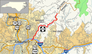
North Carolina Highway 694 is a primary state highway in the U.S. state of North Carolina. This scenic highway serves as connector between Asheville and the Blue Ridge Parkway (BRP).

Snake Mountain is a mountain located along the border between North Carolina and Tennessee, east of the community of Zionville, in the southeastern United States. It is part of the Blue Ridge Mountains, and includes parts of Watauga County, North Carolina, and Johnson County, Tennessee. It has two peaks, the highest of which reaches an elevation of 5,564 feet (1,696 m). The lower peak, at 5,518 feet (1,682 m), is Johnson County's high point.
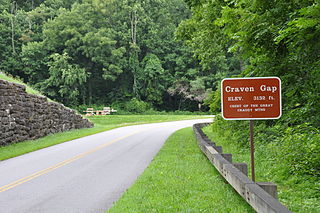
Craven Gap is a mountain pass between Peach Knob and Rice Knob, part of the Elk Mountains and Great Craggy Mountains. NC 694 connects with the Blue Ridge Parkway at the gap, where it provides direct access to downtown Asheville. The gap also has trails for hikers and is a popular bicycle rest area.
Bearwallow is an unincorporated community in Henderson County, North Carolina and is part of the Asheville Metropolitan Statistical Area. It is located along Gerton Highway (US 74A), within Hickory Nut Gorge, flanked by Burntshirt, Grant, and Little Bearwallow mountains.
Beaucatcher Tunnel carries U.S. Route 70 (US 70) and US 74A through Beaucatcher Mountain in Asheville, North Carolina. Work on the 750-foot (230 m) tunnel was started in 1927 and completed in 1929. The tunnel has two lanes and sidewalks separated from the traffic lanes by concrete barriers. It was renovated in 2014 with new stone portals.