Sauratown Mountains

Last updated
Sauratown Mountain SauratownMtn1.JPG
Sauratown Mountain

The Sauratown Mountains, which are sometimes called "the mountains away from the mountains", are an isolated mountain range located within Stokes and Surry counties in the U.S. state of North Carolina. [1] The vast majority of the range is located in Stokes County. Although the range occupies only 5% of Stokes County's area, it dominates the county's scenery from almost every direction. The Sauras rise sharply 800 to 1,700 feet (244 to 518 meters) above the surrounding terrain.

The Sauratown Mountains were named after the "Saura", a Siouan-speaking Native American tribe that lived in the area before European colonists arrived in the early 18th century. [1] The range consists of rugged, heavily forested ridges frequently broken by large quartzite rock cliffs that can be seen for miles. The Sauratown Mountains are known for offering some of the best rock climbing in North Carolina. The highest point in the Sauratown Mountains is Moore's Knob, which rises to 2,579 feet (786 m). South Stokes High School, a local high school located south of the mountains in Walnut Cove, has the Saura Indian as their mascot.

The range is home to Hanging Rock State Park, which was formed in 1936 and contains Moore's Knob and other prominent peaks. From 1935 to 1942, the Civilian Conservation Corps, a New Deal agency, built a dam and 12-acre (49,000 m2) lake in the park, as well as hiking and climbing trails and picnic and campground areas. [1]

Uniquely shaped Pilot Mountain is also located in the range. [2] [3] Pilot Mountain State Park encompasses the westernmost end of the range. A hiking and bridle trail, known as the Sauratown Trail, crosses the range and interconnects the two state parks. [1] [2] [3] [4] The Mountains-to-Sea Trail follows the Sauratown Trail and passes through both parks. [3] [4]

Peaks

Peak name Elevation Coordinates Protected area County Remarks
Stony Ridge1,361 feet (415 m) 36°17′36″N80°30′14″W / 36.29333°N 80.50389°W / 36.29333; -80.50389 [5] Pilot MountainState ParkSurryThe Corridor Trail is the closest access to the summit, but it does not go to the summit.
Pilot Mountain 2,421 feet (738 m) 36°20′24″N80°28′27″W / 36.34000°N 80.47417°W / 36.34000; -80.47417 [6] Pilot MountainState ParkSurryThe mountain's Saura name is Jomeokee. The summit area is off limits to the general public, and it is only physically accessible via rock climbing. The highest point people can get to in the park is the Little Pinnacle, a false summit.
Black Mountain1,447 feet (441 m) 36°21′36″N80°27′05″W / 36.36000°N 80.45139°W / 36.36000; -80.45139 Privately ownedSurryThe small mountain is northeast of Pilot Mountain, near the county line.
Sauratown Mountain2,441 feet (744 m) 36°22′28″N80°22′17″W / 36.37444°N 80.37139°W / 36.37444; -80.37139 [7] Privately ownedStokesBecause it is a major radio communications site, there is no public access to Sauratown Mountain. A gated, private road ends a short distance from the summit.
Brown Mountain1,550 feet (470 m) 36°27′14″N80°20′21″W / 36.45389°N 80.33917°W / 36.45389; -80.33917 [8] Privately ownedStokesThe mountain is north of Sauratown Mountain.
Ruben Mountain1,817 feet (554 m) 36°23′13″N80°18′44″W / 36.38694°N 80.31222°W / 36.38694; -80.31222 [9] Hanging RockState ParkStokesRuben is in between Sauratown Mountain and Hanging Rock. The Ruben Mountain Trail passes nearby the summit.
Devils Chimney2,396 feet (730 m) 36°22′52″N80°17′29″W / 36.38111°N 80.29139°W / 36.38111; -80.29139 [10] Hanging RockState ParkStokesThe Cook's Wall Trail ends near the summit.
Cooks Wall Mountain2,346 feet (715 m) 36°22′44″N80°17′15″W / 36.37889°N 80.28750°W / 36.37889; -80.28750 [11] Hanging RockState ParkStokesThe Cook's Wall Trail passes close by the summit.
Moore's Knob 2,579 feet (786 m) 36°23′53″N80°16′58″W / 36.39806°N 80.28278°W / 36.39806; -80.28278 [12] Hanging RockState ParkStokesThe highest point in the range. The Moore's Wall Loop Trail, a part of the Mountains-to-Sea Trail, provides access to an old fire tower on top of the knob.
Wolf Rock2,024 feet (617 m) 36°23′11″N80°16′01″W / 36.38639°N 80.26694°W / 36.38639; -80.26694 [13] Hanging RockState ParkStokesThe Wolf Rock Loop Trail crosses over this sub-summit.
Hanging Rock Mountain2,160 feet (660 m) 36°23′52″N80°15′06″W / 36.39778°N 80.25167°W / 36.39778; -80.25167 Hanging RockState ParkStokesThe Hanging Rock Trail makes the closest approach to the summit but does not go to it. The trail ends at the top of the Hanging Rock, which is below the true summit.
Flat Shoals Mountain1,660 feet (510 m) 36°22′38″N80°13′22″W / 36.37722°N 80.22278°W / 36.37722; -80.22278 [14] Hanging RockState ParkStokesThere are no park trails on this mountain.
† Approximate elevation.

Related Research Articles

<span class="mw-page-title-main">Stokes County, North Carolina</span> County in North Carolina, United States

Stokes County is a county located in the U.S. state of North Carolina. As of the 2020 census, the population was 44,520. Its county seat is Danbury.

<span class="mw-page-title-main">Black Rock Desert</span> Northwest Nevada dry lake

The Black Rock Desert is a semi-arid region of lava beds and playa, or alkali flats, situated in the Black Rock Desert–High Rock Canyon Emigrant Trails National Conservation Area, a silt playa 100 miles (160 km) north of Reno, Nevada that encompasses more than 300,000 acres (120,000 ha) of land and contains more than 120 miles (200 km) of historic trails. It is in the northern Nevada section of the Great Basin with a lakebed that is a dry remnant of Pleistocene Lake Lahontan.

<span class="mw-page-title-main">Pilot Mountain (North Carolina)</span> Mountain in United States of America

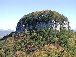
Pilot Mountain, a metamorphic quartzite monadnock rising to a peak 2,421 feet (738 m) above sea level, is one of the most distinctive natural features in the U.S. state of North Carolina. It is a remnant of the ancient chain of Sauratown Mountains. The Saura Native Americans, the region's earliest known inhabitants, called the mountain "Jomeokee", meaning "great guide".

<span class="mw-page-title-main">Hanging Rock State Park</span> State park in North Carolina, United States

Hanging Rock State Park is a 9,011-acre (3,647 ha) North Carolina state park in Stokes County, North Carolina in the United States. The park is 30 miles (48 km) north of Winston-Salem and is located approximately 2 miles (3.2 km) from Danbury in Stokes County.

<span class="mw-page-title-main">Uwharrie Mountains</span> Mountain range in North Carolina, United States

The Uwharrie Mountains are a mountain range in North Carolina spanning the counties of Randolph, Montgomery, Stanly, and Davidson. The range's foothills stretch into Cabarrus, Anson, Union, and Richmond counties.

<span class="mw-page-title-main">Catoctin Mountain</span> Mountain ridge in the United States

Catoctin Mountain, along with the geologically associated Bull Run Mountains, forms the easternmost mountain ridge of the Blue Ridge Mountains, which are in turn a part of the Appalachian Mountains range. The ridge runs northeast–southwest for about 50 miles (80 km) departing from South Mountain near Emmitsburg, Maryland, and running south past Leesburg, Virginia, where it disappears into the Piedmont in a series of low-lying hills near New Baltimore, Virginia. The ridge forms the eastern rampart of the Loudoun and Middletown valleys.

<span class="mw-page-title-main">Pinnacle, North Carolina</span> Census-designated place in North Carolina, United States

Pinnacle is an unincorporated community and census-designated place in southwestern Stokes County, North Carolina, United States, approximately 5 miles (8.0 km) SSE of the town of Pilot Mountain, between Pilot Mountain State Park and Hanging Rock State Park.

<span class="mw-page-title-main">Mountains-to-Sea Trail</span> Long-distance hiking trail in North Carolina, United States

The Mountains-to-Sea State Trail (MST) is a long-distance trail in the US for hiking and backpacking, that traverses North Carolina from the Great Smoky Mountains to the Outer Banks. Its western endpoint is at Clingman's Dome, where it connects to the Appalachian Trail in the Great Smoky Mountains National Park. Its eastern endpoint is in Jockey's Ridge State Park on the tallest sand dune on the east coast. The trail is envisioned as a scenic backbone of an interconnected trail system spanning the state. As such, its route attempts to connect as many trail systems and natural scenic areas as practicable. A little over half of the trail is complete in multiple segments across the state.

<span class="mw-page-title-main">Roan Mountain (Roan Highlands)</span>

Roan Mountain is a 6,285 ft (1,916 m) mountain straddling the North Carolina/Tennessee border in the Unaka Range of the Southern Appalachian Mountains in the Southeastern United States. The range's highpoint, Roan is clad in a dense stand of Southern Appalachian spruce-fir forest, and includes the world's largest natural rhododendron garden, and the longest stretch of grassy bald in the Appalachian range. The Roan Highlands also contain the highest quality remaining stretch of Fraser fir forest throughout the tree's entire range. The Cherokee National Forest and Pisgah National Forest converge atop the mountain, with Roan Mountain State Park located near its northern base. The Appalachian Trail traverses most of the Roan's crest. The Roan High Knob Shelter is the highest back-country shelter on the entire 2,174-mile (3,499 km) trail.

<span class="mw-page-title-main">Great Craggy Mountains</span>

The Great Craggy Mountains, commonly called the Craggies, are a mountain range in western North Carolina, United States. They are a subrange of the Blue Ridge Mountains and encompass an area of approx. 194 sq mi (503 km²). They are situated in Buncombe County, North Carolina, 14 miles northeast of Asheville. The Black Mountains lie to the northeast, across the upper Cane River valley.

<span class="mw-page-title-main">Tory's Falls (Hanging Rock)</span> Waterfall in Stokes County, North Carolina

Tory's Falls, also called Tory Falls and Torys Falls is a waterfall in North Central North Carolina, located in Hanging Rock State Park in Stokes County.

<span class="mw-page-title-main">Moore's Knob</span>

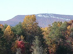
Moore's Knob is the highest mountain in the Sauratown Mountains of Stokes County, North Carolina. The Sauratown Mountains are an isolated remnant of the much larger Blue Ridge Mountains far to the west and north. A rugged, deeply eroded range, the Sauras feature dramatic rock cliffs which can be seen for miles. Moore's Knob has an elevation of 2,579 feet above sea level.

<span class="mw-page-title-main">Bear's Paw</span> Mountain in North Carolina, United States

Hanging Rock, also known as Bear's Paw, is a mountain in the North Carolina High Country, next to the town of Seven Devils. It is along the Avery and Watauga border. Its elevation reaches 5,203 feet (1,586 m). The mountain generates feeder streams for the Elk and Watauga rivers.

<span class="mw-page-title-main">Sauratown Trail</span> Trail in North Carolina, United States

Sauratown Trail is a hiking and bridle trail in Stokes and Surry counties, North Carolina, which crosses the Sauratown Mountains and interconnects Pilot Mountain State Park and Hanging Rock State Park. It is the only bridle trail which goes between two NC State Parks. The trail is located primarily on leased, privately owned lands, and it is the longest publicly open trail on private lands in the state. The trail consists of a main trail of 22.2 miles (35.7 km) and two spur loops each about 6 miles (9.7 km) around. Altogether, the Sauratown Trail and its spurs total over 30 miles (48 km) of trail. The trail was dedicated by the Sauratown Trail Committee in October 1979. Since 2002, most of the main trail has been designated a part of the Mountains-to-Sea Trail.

<span class="mw-page-title-main">Canyons of the Teton Range</span> Canyons in Wyoming, United States

The canyons of the Teton Range lie almost entirely within Grand Teton National Park in the U.S. state of Wyoming. Ranging from 9 miles (14 km) to less than 1 mile (1.6 km) in length and up to 6,000 feet (1,800 m) deep, the canyons were carved primarily by glaciers over the past 250,000 years. The canyons in the Teton Range descend in altitude generally west to east and many have lakes at their outlets. The lakes were created by terminal moraines left behind by the now retreated glaciers. A few of the canyons have small glaciers that were created mostly during the Little Ice Age (1550-1850). Fast retreating Schoolroom Glacier is a tiny glacier located at the head of the South Cascade Canyon. Most of the canyons have streams from which rain and snowmelt flow towards Jackson Hole valley, and due to the sometimes rapid altitude descent, waterfalls are common. The canyons offer the easiest hiking access into the Teton Range.

<span class="mw-page-title-main">Theodore Roosevelt State Natural Area</span> North Carolina state park

Theodore Roosevelt State Natural Area is a 265-acre (1.07 km2) North Carolina state park in Carteret County, North Carolina, in the United States. Located on Bogue Banks, in the town of Pine Knoll Shores, the natural area protects the barrier island's only remaining intact maritime forest. It is bounded by NC 58 to the south, Bogue Sound to the north, and private development to the east and west.

<span class="mw-page-title-main">Snake Mountain (North Carolina – Tennessee)</span> Mountain in United States of America

Snake Mountain is a mountain located along the border of North Carolina and Tennessee, east of the community of Zionville, in the southeastern United States. It is part of the Blue Ridge Mountains, and includes parts of Watauga County, North Carolina, and Johnson County, Tennessee. It has two peaks, the higher of which reaches an elevation of 5,564 feet (1,696 m). The lower peak, at 5,518 feet (1,682 m), is Johnson County's high point.

Bluerock Mountain is a mountain in Western North Carolina, near the community of Bat Cave. It is split between Henderson and Rutherford counties, it is home of the Bat Cave Preserve and part of Chimney Rock State Park. Its elevation reaches 2,835 feet (864 m).

Rich Mountain is roughly 7 miles (11 km) south-southwest of Boone, in Moses H. Cone Memorial Park. Its elevation reaches 4,246 feet (1,294 m). Because it's within the Blue Ridge Parkway, it is protected from development. From 1922-1985, Camp Yonahlossee was located at the western side of the mountain, it was one of the oldest all girls camp in North Carolina; today it is a resort and club.

References

  1. 1 2 3 4 Biggs, Jr., Walter C.; Parnell, James F. (1993) [1989]. "Piedmont". State Parks of North Carolina (2nd ed.). Winston-Salem, North Carolina: John F. Blair. pp. 142–152. ISBN   0-89587-071-1.
  2. 1 2 Biggs, Jr., Walter C.; Parnell, James F. (1993) [1989]. "Piedmont". State Parks of North Carolina (2nd ed.). Winston-Salem, North Carolina: John F. Blair. pp. 176–187. ISBN   0-89587-071-1. Pilot Mountain, like the rocky escarpments in nearby Hanging Rock State Park, is a remnant of the ancient Sauratown Mountain range.
  3. 1 2 3 Lynch, Ida Phillips; Pendergraft, Bill (2007). "Piedmont". North Carolina State Parks: A Niche Guide. Design by Leesa Brinkley Graphic Design. Chapel Hill, North Carolina: Niche Publishing. pp. 58–59. ISBN   978-0-9794591-0-8. Like nearby Hanging Rock, this monadnock is a remnant of the ancient Sauratown Mountain range.
  4. 1 2 Lynch, Ida Phillips; Pendergraft, Bill (2007). "Piedmont". North Carolina State Parks: A Niche Guide. Design by Leesa Brinkley Graphic Design. Chapel Hill, North Carolina: Niche Publishing. pp. 40–41. ISBN   978-0-9794591-0-8. Hanging Rock State Park is located at the eastern end of the isolated Sauratown Mountain range.
  5. "Stony Ridge". Geographic Names Information System . United States Geological Survey, United States Department of the Interior . Retrieved 2011-10-02.
  6. "Pilot Mountain". Geographic Names Information System . United States Geological Survey, United States Department of the Interior . Retrieved 2011-10-02.
  7. "Sauratown Mountain". Geographic Names Information System . United States Geological Survey, United States Department of the Interior . Retrieved 2011-10-02.
  8. "Brown Mountain". Geographic Names Information System . United States Geological Survey, United States Department of the Interior . Retrieved 2011-10-02.
  9. "Ruben Mountain". Geographic Names Information System . United States Geological Survey, United States Department of the Interior . Retrieved 2011-10-02.
  10. "Devils Chimney". Geographic Names Information System . United States Geological Survey, United States Department of the Interior . Retrieved 2011-10-02.
  11. "Cooks Wall Mountain". Geographic Names Information System . United States Geological Survey, United States Department of the Interior . Retrieved 2011-10-02.
  12. "Moores Knob". Geographic Names Information System . United States Geological Survey, United States Department of the Interior . Retrieved 2011-10-02.
  13. "Wolf Rock". Geographic Names Information System . United States Geological Survey, United States Department of the Interior . Retrieved 2011-10-02.
  14. "Flat Shoal Mountain". Geographic Names Information System . United States Geological Survey, United States Department of the Interior . Retrieved 2011-10-02.