Wilkes County is a county located in the U.S. state of North Carolina. It is a part of the state's western mountain region. As of the 2020 census the population was 65,969. Its county seat is Wilkesboro, and its largest town is North Wilkesboro. Wilkes County comprises the North Wilkesboro, NC Micropolitan Statistical Area.

Watauga County is a county located in the U.S. state of North Carolina. As of the 2020 census, the population was 54,086. Its county seat and largest town is Boone. The county is in an exceptionally mountainous region. It is the home of Appalachian State University, which has approximately 20,023 students as of August 20, 2020. Watauga County comprises the Boone, NC Micropolitan Statistical Area.

Iredell County is a county located in the U.S. state of North Carolina. As of the 2020 census, the population was 186,693. Its county seat is Statesville, and its largest town is Mooresville. The county was formed in 1788, subtracted from Rowan County. It is named for James Iredell, one of the first justices of the Supreme Court. Iredell County is included in the Charlotte-Concord-Gastonia, NC-SC Metropolitan Statistical Area, as defined in 2013 by the Office of Management and Budget with data from the U.S. Census Bureau.

Caldwell County is a county in the U.S. state of North Carolina. It is located in the foothills of the Blue Ridge Mountains. As of the 2020 census, the population was 80,652. Its county seat is Lenoir. Caldwell County is part of the Hickory-Lenoir-Morganton, NC Metropolitan Statistical Area.
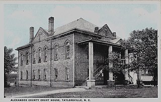
Alexander County is a county established in the U.S. state of North Carolina in 1847. As of the 2020 census, the population was 36,444. Its county seat is Taylorsville. Alexander County is part of the Hickory-Lenoir-Morganton, NC Metropolitan Statistical Area.
Love Valley is a town in Iredell County, North Carolina, United States. It also extends into Alexander County on its western end. The population was 90 at the 2010 census, and in 2020 the estimated population was 154.

North Wilkesboro is a town in Wilkes County, North Carolina, United States. The population was 4,131 at the 2020 US Census. North Wilkesboro is the birthplace and original home of Lowe's Home Improvement, which continues to have a major presence in the community. The town is also known as one of the birthplaces of the sport of stock-car racing, and the North Wilkesboro Speedway was the first NASCAR-sanctioned track. Due to the town's proximity to the nearby Blue Ridge Mountains and its numerous tourist venues, North Wilkesboro has been nicknamed the "Key to the Blue Ridge".
Wilkesboro is a town in and the county seat of Wilkes County, North Carolina, United States. The population was 3,687 at the 2020 census. The town is located along the south bank of the Yadkin River, directly opposite the town of North Wilkesboro. Wilkesboro is a Small Town Main Street community and has recently revitalized its historic downtown to include the Carolina West Wireless Community Commons, Wilkes Communications Pavilion, Heritage Square and Splash Pad. Cub Creek Park is adjacent to the downtown and contains many amenities, which include baseball, walking trails, mountain biking trails, trout fishing, dog park, basketball, tennis, and pickleball courts, picnic shelters, etc. Wilkesboro is also the home of the annual MerleFest, Carolina in the Fall, and Brushy Mountain Peach & Heritage festivals.

The geography of North Carolina falls naturally into three divisions — the Appalachian Mountains in the west, the central Piedmont Plateau, and the eastern Atlantic Coastal Plain. North Carolina covers 53,819 square miles (139,391 km2) and is 503 miles (810 km) long by 150 miles (241 km) wide. The physical characteristics of the state vary from the summits of the Smoky Mountains, an altitude of near seven thousand feet (2,130 m) in the west, sloping eastward to sea level along the coast and beaches of the Atlantic Ocean.

The Yadkin River is one of the longest rivers in the US state of North Carolina, flowing 215 miles (346 km). It rises in the northwestern portion of the state near the Blue Ridge Parkway's Thunder Hill Overlook. Several parts of the river are impounded by dams for water, power, and flood control. The river becomes the Pee Dee River at the confluence of the Uwharrie River south of the community of Badin and east of the town of Albemarle. The river then flows into South Carolina near Cheraw, which is at the Fall Line. The entirety of the Yadkin River and the Great Pee Dee River is part of the Yadkin-Pee Dee River Basin.

Pores Knob is a mountain peak located in Wilkes County, North Carolina, US.
The Reddies River is a tributary of the Yadkin River in northwestern North Carolina in the United States. Via the Yadkin it is part of the watershed of the Pee Dee River, which flows to the Atlantic Ocean. According to the Geographic Names Information System, it has also been known historically as "Reddis River."

Western North Carolina is the region of North Carolina which includes the Appalachian Mountains; it is often known geographically as the state's Mountain Region. It contains the highest mountains in the Eastern United States, with 125 peaks rising to over 5,000 feet in elevation. Mount Mitchell at 6,684 feet, is the highest peak of the Appalachian Mountains and mainland eastern North America. The population of the region, as measured by the 2010 U.S. Census, is 1,473,241, which is approximately 15% of North Carolina's total population.

North Carolina Highway 18 (NC 18) is a primary state highway in the U.S. state of North Carolina. Traveling north–south through the Foothills region, it connects the cities of Shelby, Morganton, Lenoir, Wilkesboro and North Wilkesboro.
Wilkes Central High School is a public high school located in Moravian Falls, North Carolina. It is a part of the Wilkes County Schools system. The school's enrollment is typically around 1,000 students. The school's district includes the towns of Wilkesboro and North Wilkesboro as well as the southern regions of Wilkes County. The current principal of the school is Dr. Heather Freeman. Wilkes Central has the largest enrollment of Wilkes County's four public high schools.
The South Mountains are an ancient and deeply eroded mountain range in western North Carolina. They are an isolated remnant of the much larger Appalachian Mountains to the west, and are separated from the Appalachians by the Catawba River valley. The range covers approximately 100,000 acres (400 km²) in Burke, Cleveland, McDowell and Rutherford counties. The South Mountains are the highest and most rugged chain of the isolated mountain ranges which dot North Carolina's Piedmont region. The highest point in the range is Icy knob which rises to 3,000 feet above sea level. The South Mountains are heavily forested with Southeastern mixed forests. Water erosion from numerous rivers and streams has given the mountains narrow ridges and valleys.
The Brushy Mountain Apple Festival is a one-day arts and crafts fair held annually in downtown North Wilkesboro, North Carolina. Founded in 1978, the fair is held on the first Saturday in October. Over 160,000 people visit the fair each year, and it is one of the largest single-day arts and crafts fairs in the Southeastern United States. The fair is held to celebrate the apple harvest from the nearby Brushy Mountains. Over 100 church, civic, and other non-profit organizations from Wilkes County and neighboring counties participate in the fair each year.

North Carolina Highway 268 (NC 268) is a primary state highway in the U.S. state of North Carolina. It connects many communities as it traverses through the northwestern North Carolina mountains and foothills.
The Swan Creek AVA is an American Viticultural Area located in the northwestern portion of North Carolina, in the Piedmont region. The appellation is distinguished by its loamy soil with schist and mica. Established May 27, 2008, it is the second AVA to be established in North Carolina. It is a sub-appellation of the Yadkin Valley AVA.