
North Carolina is a state in the Southeastern region of the United States. It is bordered by Virginia to the north, the Atlantic Ocean to the east, South Carolina to the south, Georgia to the southwest, and Tennessee to the west. The state is the 28th-largest and 9th-most populous of the United States. Along with South Carolina, it makes up the Carolinas region of the East Coast. At the 2020 census, the state had a population of 10,439,388. Raleigh is the state's capital and Charlotte is its most populous city. The Charlotte metropolitan area, with an estimated population of 2,805,115 in 2023, is the most populous metropolitan area in North Carolina, the 22nd-most populous in the United States, and the largest banking center in the nation after New York City. The Research Triangle, with an estimated population of 2,368,947 in 2023, is the second-most populous combined metropolitan area in the state, 31st-most populous in the United States, and is home to the largest research park in the United States, Research Triangle Park.

Surry County is a county located in the U.S. state of North Carolina. As of the 2020 census, the population was 71,359. Its county seat is Dobson, and its largest community is Mount Airy.

Mount Mitchell, known in Cherokee as Attakulla, is the highest peak of the Appalachian Mountains and the highest peak in mainland North America east of the Mississippi River. It is located near Burnsville in Yancey County, North Carolina in the Black Mountain subrange of the Appalachians about 19 miles (31 km) northeast of Asheville. It is protected by Mount Mitchell State Park and surrounded by the Pisgah National Forest. Mount Mitchell's elevation is 6,684 feet (2,037 m) above sea level. Mount Mitchell is ranked 31st by topographic isolation.

The Great Appalachian Valley, also called The Great Valley or Great Valley Region, is one of the major landform features of eastern North America. It is a gigantic trough, including a chain of valley lowlands, and the central feature of the Appalachian Mountains system. The trough stretches about 1,200 miles (1,900 km) from Quebec in the north to Alabama in the south and has been an important north–south route of travel since prehistoric times.
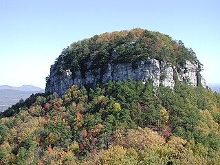
Pilot Mountain, a metamorphic quartzite monadnock rising to a peak 2,421 feet (738 m) above sea level, is one of the most distinctive natural features in the U.S. state of North Carolina. It is a remnant of the ancient chain of Sauratown Mountains. The Saura Native Americans, the region's earliest known inhabitants, called the mountain "Jomeokee", meaning "great guide".

The Piedmont is a plateau region located in the Eastern United States. It is situated between the Atlantic Plain and the Blue Ridge Mountains, stretching from New York in the north to central Alabama in the south. The Piedmont Province is a physiographic province of the larger Appalachian Highlands physiographic division and consists of the Piedmont Upland, and the Piedmont Lowlands sections.

The geography of North Carolina falls naturally into three divisions — the Appalachian Mountains in the west, the central Piedmont Plateau, and the eastern Atlantic Coastal Plain. North Carolina covers 53,819 square miles (139,391 km2) and is 503 miles (810 km) wide by 150 miles (241 km) long. The physical characteristics of the state vary from the summits of the Smoky Mountains, an altitude of near seven thousand feet (2,130 m) in the west, sloping eastward to sea level along the coast and beaches of the Atlantic Ocean.

Morrow Mountain State Park is a state park in Stanly County, North Carolina, U.S. Located near Albemarle, the park includes 5,881 acres (23.80 km2) within the Uwharrie Mountains.

The Catawba River is a major river located in the Southeastern United States. It originates in Western North Carolina and flows into South Carolina, where it later becomes known as the Wateree River. The river is approximately 220 miles (350 km) long. It rises in the Appalachian Mountains and drains into the Piedmont, where it has been impounded through a series of reservoirs for flood control and generation of hydroelectricity. The river is named after the Catawba tribe of Native Americans, which lives on its banks. In their language, they call themselves "yeh is-WAH h’reh", meaning "people of the river."

The Battle of Kings Mountain was a military engagement between Patriot and Loyalist militias in South Carolina during the Southern Campaign of the American Revolutionary War, resulting in a decisive victory for the Patriots. The battle took place on October 7, 1780, 9 miles (14 km) south of the present-day town of Kings Mountain, North Carolina. In what is now rural Cherokee County, South Carolina, the Patriot militia defeated the Loyalist militia commanded by British Major Patrick Ferguson of the 71st Foot. The battle has been described as "the war's largest all-American fight".

Mars Hill University is a private Christian university in Mars Hill, North Carolina. The university offers 35 undergraduate majors and includes a school of nursing and graduate schools in education, criminal justice, and management. From 1859 to 2013 the school was called Mars Hill College; in August 2013 it officially changed its name to Mars Hill University.

Pisgah National Forest is a National Forest in the Appalachian Mountains of western North Carolina. It is administered by the United States Forest Service, part of the United States Department of Agriculture. The Pisgah National Forest is completely contained within the state of North Carolina. The forest is managed together with the other three North Carolina National Forests from common headquarters in Asheville, North Carolina. There are local ranger district offices located in Pisgah Forest, Mars Hill, and Nebo.
Foothills or piedmont are geographically defined as gradual increases in elevation at the base of a mountain range, higher hill range or an upland area. They are a transition zone between plains and low relief hills and the adjacent topographically higher mountains, hills, and uplands. Frequently foothills consist of alluvial fans, coalesced alluvial fans, and dissected plateaus.

Western North Carolina is the region of North Carolina which includes the Appalachian Mountains; it is often known geographically as the state's Mountain Region. It contains the highest mountains in the Eastern United States, with 125 peaks rising to over 5,000 feet in elevation. Mount Mitchell at 6,684 feet, is the highest peak of the Appalachian Mountains and mainland eastern North America. The population of the 23 most commonly associated counties for the region, as measured by the 2020 U.S. Census, is 1,149,405. The region accounts for approximately 11% of North Carolina's total population.

The Great Indian Warpath (GIW)—also known as the Great Indian War and Trading Path, or the Seneca Trail—was that part of the network of trails in eastern North America developed and used by Native Americans which ran through the Great Appalachian Valley. The system of footpaths extended from what is now upper New York to deep within Alabama. Various Native peoples traded and made war along the trails, including the Catawba, numerous Algonquian tribes, the Cherokee, and the Iroquois Confederacy. The British traders' name for the route was derived from combining its name among the northeastern Algonquian tribes, Mishimayagat or "Great Trail", with that of the Shawnee and Delaware, Athawominee or "Path where they go armed".
Central North Carolina, also known as the Piedmont, is a region of North Carolina. It is located between the Mountains to the west and the Coastal Plain to the east. It is the most populous region of the state, containing Charlotte, the state capital of Raleigh, and Greensboro. These cities form the Piedmont Crescent region, much of which parallels I-85. The geography of the Piedmont primarily consists of rolling hills. Historically the region has been known for furniture and textile manufacturing.

The Charlotte metropolitan area, sometimes referred to as Metrolina, is a metropolitan area of the U.S. states of North and South Carolina, containing the city of Charlotte. The metropolitan area also includes the cities of Gastonia, Concord, Huntersville, and Rock Hill as well as the large suburban area in the counties surrounding Mecklenburg County, which is at the center of the metro area. Located in the Piedmont, it is the largest metropolitan area in the Carolinas, and the fourth largest in the Southeastern United States. The Charlotte metropolitan area is one of the fastest growing metropolitan areas in the United States.

The Oconaluftee River drains the south-central Oconaluftee valley of the Great Smoky Mountains in Western North Carolina before emptying into the Tuckasegee River. The river flows through the Qualla Boundary, a federal land trust that serves as a reserve for the Eastern Band of the Cherokee, the only federally recognized tribe in North Carolina. They bought the land back from the federal government in the 1870s, after having been pushed off and forced to cede it earlier in the 19th century. Several historic Cherokee towns are known to have been located along this river.