Sugarland Mountain Trail

Last updated
Sugarland Mountain Trail
Sugarland-mountain-trailhead-tn1.jpg
Sugarland Mountain Trailhead at Fighting Creek Gap
Length12 mi (19 km)
Location Great Smoky Mountains National Park, Tennessee, United States
Trailheads Fighting Creek Gap (along Little River Road, W. of Gatlinburg)
Junction with the Appalachian Trail near the summit of Mount Collins
UseHiking
Highest pointAppalachian Trail junction, 5,900 ft (1,800 m)
Lowest pointFighting Creek Gap, 2,300 ft (700 m)
DifficultyModerate-to-Strenuous
SeasonOpen year-round
SightsViews of Mount Le Conte, Gatlinburg and Sevier County to the east, Blanket Mountain and Upper Little River Valley to the west; multiple forest types
Hazards Steep ledges, ice hazards in colder months

The Sugarland Mountain Trail is an American hiking trail, in the Great Smoky Mountains National Park of Sevier County, Tennessee. The trail traverses Sugarland Mountain, a massive ridge running perpendicular to the main crest of the Smokies and effectively dividing the park's north-central section from its northwestern section. Sugarland Mountain is flanked by the deep upper valleys of two of the park's major watersheds— the West Fork of the Little Pigeon River (to the east) and Little River (to the west). The trail passes through several forest types, including deciduous forest at lower elevations, heaths ("hells") along the mountain's backbone formations, and a stand of Southern Appalachian spruce-fir forest in the upper elevations. Occasional breaks in the foliage allow for views of Mount Le Conte and Sevier County to the east and Blanket Mountain and the ridges above Elkmont to the west.

Contents

The trailhead is located at Fighting Creek Gap along Little River Road, between Gatlinburg and Elkmont. The trail's terminus is located just off Clingmans Dome Road, where the trail intersects the Appalachian Trail.

Vital information

Landmarks/overlooks

Looking west from an overlook appx. 6 miles from the trailhead Sugarland-mtn-trail-west1.jpg
Looking west from an overlook appx. 6 miles from the trailhead
Sugarland mountain Sugarland mountain.jpg
Sugarland mountain

Geographical information

The trail crossing a backbone 9-10 miles from the trailhead. The snow on the left will eventually end up in Little River, 2000 feet below. The snow on the right will end up in the Little Pigeon River. Sugarland-mountain-trail-backbone-tn1.jpg
The trail crossing a backbone 9-10 miles from the trailhead. The snow on the left will eventually end up in Little River, 2000 feet below. The snow on the right will end up in the Little Pigeon River.

Sugarland Mountain is a ridge that consists of a series knobs and peaks, each increasing in elevation as the mountain approaches its junction with the main Smokies crest. The northernmost knobs, which overlook Fighting Creek Gap and Mids Gap, have elevations of around 3,000 feet (910 m). Beyond Huskey Gap, the mountain rises sharply to its prominent 4,833-foot (1,473 m) northern peak as the crest narrows, and maintains an elevation of 4,300 feet (1,300 m) to 4,800 feet (1,500 m) for several miles. At the headwaters of Rough Creek, the mountain rises above 5,000 feet (1,500 m) for the first time, eventually reaching 5,494 feet (1,675 m) at its summit. The Chimney Tops, which consist of two barren slate capstones, crown a narrow ridge that branches off the southeastern slope of Sugarland Mountain, opposite the Rough Creek headwaters. Sugarland Mountain's various knobs and peaks are typically connected by narrow "backbone" ridges, some of which are just a few feet wide. The relatively broad Huskey Gap— between the mountain's northern peak and its lower northern knobs— is the exception.

Several mountain streams have their sources high on slopes of Sugarland Mountain. Streams on the western side of the mountain include Mids Branch, Phoebe Branch, Big Medicine Branch, and Rough Creek. These all empty into Little River, which proceeds northward to Elkmont, veers west through the Little River Gorge, and turns north again to traverse Blount County before emptying into the Fort Loudoun Lake impoundment of the Tennessee River. Streams on the western side of the mountain include Sugarland Branch, Hickory King Branch, and Road Prong. These empty into the West Fork of the Little Pigeon River, which proceeds northward through Gatlinburg, Pigeon Forge and Sevierville, where it merges with the Little Pigeon River proper before emptying into the French Broad River.

Historical information

The Sugarland Mountain Trail at Huskey Gap, with the northern peak visible through the treeline Sugarland-mountain-trail-huskey-gap1.jpg
The Sugarland Mountain Trail at Huskey Gap, with the northern peak visible through the treeline

In Cherokee lore, the eastern slopes of Sugarland Mountain— along with the northern slopes of Mount Le Conte— were part of a ridgeline known as Walasi'yi, or "Frog Place." [1] An ancient Native American trail— possibly predating the Cherokee— crossed the crest at Indian Gap and descended along Road Prong to the West Fork of the Little Pigeon Valley. The trail then followed the valley northward, where it intersected the Great Indian Warpath near modern Sevierville. This trail was expanded several times by Euro-American settlers throughout the 19th century. While the main road gradually shifted to the lower Newfound Gap, the Road Prong Trail still follows this ancient road. [2]

The Rough Creek Valley - Horace Kephart's "Godforsaken" Sugarland-mtn-trail-rough-crk-valley1.jpg
The Rough Creek Valley - Horace Kephart's "Godforsaken"

In the late 19th century, the residents of Little River (now Elkmont) and the Sugarlands built a log schoolhouse at Huskey Gap. To allow easier access to the school, they constructed a crude road along what is now the Huskey Gap Trail. [3] Although the schoolhouse had burned down by 1916, [4] the trail received continued use by Sugarlanders working in logging camps in the Elkmont vicinity in the 1920s. [5] By the time the Great Smoky Mountains Park Commission started buying up tracts of land in the late 1920s for the formation of the national park, the Little River Lumber Company owned the entire western side of Sugarland Mountain and the Champion Fibre Company owned the mountain's southeastern section. [6] Members of the Parton family and Huskey family owned small farms around Huskey Gap and the headwaters of Sugarland Branch, and members of the Quilliams family lived in the vicinity of Backcountry Campsite 21. [7]

Author Horace Kephart, writing in the early 20th century, described Sugarland Mountain as a "razorback ridge" that formed a "rampart tedious to scale from either side." [8] Kephart referred to the upper Rough Creek Valley on the mountain's southwestern slope as "Godforsaken" — a remote land that seemed "unearthly in its dreariness and desolation." [9] In "A Raid Into the Sugarlands," Kephart gave a quasi-factual account of a North Carolina deputy's excursion into the Sugarlands to apprehend a fugitive. The deputy and his hodgepodge posse chased the fugitive across Sugarland Mountain to "Barradale's upper logging camp" on Rough Creek, although they failed to locate him. They returned to North Carolina empty-handed the following day. [10]

George McCoy, writing in an early park guide in 1935, reported that the Sugarland Mountain Trail was "extremely rugged," but offered excellent views of Mount Le Conte. [11] In 1937, Laura Thornborough— who wrote extensively of hiking trails in the Smokies— echoed McCoy's description, calling the Sugarland Mountain Trail "rugged and rough," but well worth an all-day trip. [12]

Trail synopsis

Fighting Creek Gap to Huskey Gap — 3.1 miles

Mount Le Conte, viewed from a break in the foliage a mile or so from the trailhead Mount-le-conte-from-smt1.jpg
Mount Le Conte, viewed from a break in the foliage a mile or so from the trailhead

The first half-mile or so of the Sugarland Mountain Trail is uphill as the trail rises out of Fighting Creek Gap and winds its way around the eastern side of the mountain's northernmost knob. After descending to Mids Gap (an unmarked manway follows Mids Branch to the Elkmont Nature Trail, a mile or so to the west), the trail swings to the western slope of the mountain, where it winds its way up and around a second knob and gradually descends to Huskey Gap.

At Huskey Gap, the Sugarland Mountain Trail, which runs north-to-south, intersects the Huskey Gap Trail, which runs roughly east-to-west. The eastern half of the Huskey Gap Trail descends to Newfound Gap Road (U.S. Route 441), and continues as a "Quiet Walkway" to the ruins of the Sugarlands community along the banks of the West Fork of the Little Pigeon River. The western half of the Huskey Gap Trail descends to the Little River Trail and Little River, just upstream from Elkmont.

Huskey Gap to Rough Creek Trail junction — 4.2 miles

View of Sevier County from a backbone between the north peak and the Rough Creek Trail Sevier-co-sugarland-mountain-tn1.jpg
View of Sevier County from a backbone between the north peak and the Rough Creek Trail

The Huskey Gap-to-Rough Creek section of the Sugarland Mountain Trail is characterized by heaths and boulder fields as it winds its way around the western slope of Sugarland Mountain's 4,833-foot (1,473 m) northern peak. This peak comes into clear view as the trail enters its first substantial stand of heath immediately south of Huskey Gap.

As the trail begins to ascend the northern peak, it reenters a thick deciduous forest. The headwaters of various streams have cut a series of hollows into the western flank of this peak, leading down into the Little River Valley. These upper hollows are littered with boulders, which over the years have broken off from higher elevations and have been carried down into the streambeds by erosional forces. Backcountry Campsite 21 was formerly located amidst the first of these boulder fields in the headwaters of Big Medicine Branch prior to being relocated to the Huskey Gap Trail near the junction with Little River Trail.

Sandstone outcroppings are not uncommon along the steep western slope of the north peak. Approximately 1 mile (1.6 km) from the campsite, a pile of large rocks allows for an unobstructed view out over the Little River Valley westward to Miry Ridge and Blanket Mountain. Beyond the north peak, the trail traverses its first substantial backbone. Gatlinburg and Newfound Gap Road are visible through the treeline to the east.

Rough Creek Trail junction to Appalachian Trail — 4.8 miles

Mount Mingus, visible appx. 10 miles from the trailhead Sugarland-mountain-trail-mingus1.jpg
Mount Mingus, visible appx. 10 miles from the trailhead

The Rough Creek-to-Appalachian Trail segment of the Sugarland Mountain Trail is its most rugged and most strenuous. Most of the remainder of the trail consists of sharp ascents over steep ledges alternating with smooth strolls over narrow backbones. Approximately one mile of the lower section of trail was burned during the catastrophic wildfirefire that occurred in the area in November 2016. This portion of the trail is now overgrown with tall weeds and brambles in summertime. At just over 8 miles (13 km), a break in the foliage allows for an unobstructed view of the Rough Creek Valley below and Sweet Ridge and Miry Ridge in the distance to the northwest and west. Mount Le Conte dominates the view through the treeline to the east.

The Sugarland Mountain Trail terminus Sugarland-mountain-trail-at-junction1.jpg
The Sugarland Mountain Trail terminus

Around 10 miles (16 km) from the trailhead, the Sugarland Mountain Trail passes just below the mountain's 5,494-foot (1,675 m) summit, which rises at the mountain's junction with Sweet Ridge. Beyond the summit, Mount Collins becomes visible through the treeline to the south, and Mount Mingus dominates the view to the east. After winding its way across Sugarland Mountain's upper elevations, the trail ascends sharply to the Mount Collins Shelter and the trail terminus along the Appalachian Trail.

West of the Sugarland Mountain Trail terminus, the Appalachian Trail continues to ascend sharply, crossing the 6,188-foot (1,886 m) summit of Mount Collins and continuing onward to Clingmans Dome. A small footpath east of the trail terminus leads to Clingmans Dome Road and the Fork Ridge Trail terminus on the other side of the road. Newfound Gap is approximately 4.5 miles (7.2 km) east of the trail terminus.

The Mount Collins Shelter is situated just off the Sugarland Mountain Trail approximately 0.3 miles (0.48 km) north of the trail's terminus at the Appalachian Trail. A spring— part of the headwaters of Moccasin Branch— provides the shelter's water source. The shelter— built of stone and enclosed by fencing at one end— is typical of Appalachian Trail shelters in the area.

Related Research Articles

<span class="mw-page-title-main">Gatlinburg, Tennessee</span> City in Tennessee, United States

Gatlinburg is a mountain resort city in Sevier County, Tennessee. It is located 39 miles (63 km) southeast of Knoxville and had a population of 3,944 at the 2010 Census and a U.S. Census population of 3,577 in 2020. It is a popular vacation resort, as it rests on the border of Great Smoky Mountains National Park along U.S. Route 441, which connects to Cherokee, North Carolina, on the southeast side of the national park. Prior to incorporation, the town was known as White Oak Flats, or simply White Oak.

<span class="mw-page-title-main">Great Smoky Mountains National Park</span> National park in Tennessee and North Carolina

Great Smoky Mountains National Park is an American national park in the southeastern United States, with parts in North Carolina and Tennessee. The park straddles the ridgeline of the Great Smoky Mountains, part of the Blue Ridge Mountains, which are a division of the larger Appalachian Mountain chain. The park contains some of the highest mountains in eastern North America, including Clingmans Dome, Mount Guyot, and Mount Le Conte. The border between the two states runs northeast to southwest through the center of the park. The Appalachian Trail passes through the center of the park on its route from Georgia to Maine. With 14.1 million visitors in 2021, the Great Smoky Mountains National Park is the most visited national park in the United States.

<span class="mw-page-title-main">Great Smoky Mountains</span> American mountain range along North Carolina/Tennessee border

The Great Smoky Mountains are a mountain range rising along the Tennessee–North Carolina border in the southeastern United States. They are a subrange of the Appalachian Mountains and form part of the Blue Ridge Physiographic Province. The range is sometimes called the Smoky Mountains, and the name is commonly shortened to the Smokies. The Smokies are best known as the home of the Great Smoky Mountains National Park, which protects most of the range. The park was established in 1934 and, with over 11 million visits per year, is the most visited national park in the United States.

<span class="mw-page-title-main">Little River (Tennessee)</span> River in Tennessee, United States

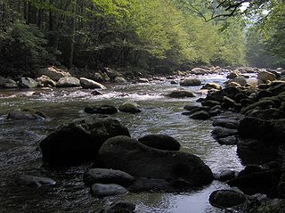
Little River is a 60-mile (97 km) river in Tennessee which drains a 380-square-mile (980 km2) area containing some of the most spectacular scenery in the southeastern United States. The first 18 miles (29 km) of the river are all located within the borders of the Great Smoky Mountains National Park. The remaining 42 miles (68 km) flow out of the mountains through Blount County to join the Tennessee River at Fort Loudon Lake in Knox County.

<span class="mw-page-title-main">Clingmans Dome</span> Mountain, highest peak in Tennessee, United States

Clingmans Dome is a mountain in the Great Smoky Mountains of Tennessee and North Carolina in the Southeastern United States. Its name in Cherokee is Kuwahi or Kuwohi, meaning "mulberry place."

<span class="mw-page-title-main">Elkmont, Tennessee</span> United States historic place

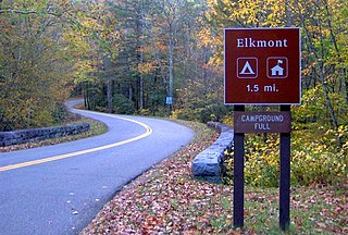
Elkmont is a region situated in the upper Little River valley of the Great Smoky Mountains of Sevier County, in the U.S. state of Tennessee. Throughout its history, the valley has been home to a pioneer Appalachian community, a logging town, and a resort community. Today, Elkmont is home to a large campground, ranger station, and historic district maintained by the Great Smoky Mountains National Park.

<span class="mw-page-title-main">The Boulevard Trail</span> Hiking trail in Tennessee, United States

The Boulevard Trail is an American hiking trail in the Great Smoky Mountains National Park, in Sevier County, Tennessee. The trail ascends Mount Le Conte, the tallest mountain east of the Mississippi River and offers high-elevation views before terminating near the LeConte Lodge.

<span class="mw-page-title-main">Hiking in the Great Smoky Mountains National Park</span>

The Great Smoky Mountains National Park is a United States National Park located in a region of the Appalachian Mountains referred to as the Great Smoky Mountains, in a portion of east-central Tennessee and southwest North Carolina. With over 150 hiking trails extending for more than 850 miles (1,370 km), within its boundaries, including a seventy-mile segment of the Appalachian Trail, hiking is the most popular activity in the national park.

<span class="mw-page-title-main">Chimney Tops</span> Mountain in Tennessee, US

Chimney Tops is a mountain in the central Great Smoky Mountains in Tennessee. It is 4,724 feet (1,440 m) above sea level. Chimney Tops is a double-capstone knob on the eastern slope of the Sugarland Mountain massif, which stretches north-south across the north-central section of the Smokies. Mount Le Conte resides east of Chimney Tops and Mt. Mingus southeast of Chimney Tops. Thus, while the view from the summit is 360 degrees, Chimney Tops is practically "walled in" on three sides.

<span class="mw-page-title-main">Silers Bald</span>

Silers Bald is a mountain in the western Great Smoky Mountains, located in the southeastern United States with the Great Smoky Mountains National Park. Its proximity to Clingmans Dome and its location along the Appalachian Trail make it a popular hiking destination.

<span class="mw-page-title-main">Mount Kephart</span> Mountain in United States of America

Mount Kephart is a mountain in the central Great Smoky Mountains, located in the Southeastern United States. The Appalachian Trail crosses the mountain's south slope, making it a destination for thru-hikers. The Jumpoff, a 1,000-foot (300 m) cliff on the northeast side of the mountain, has views of the central and eastern Smokies. A stand of Southern Appalachian spruce-fir forest coats the mountain's upper elevations.

<span class="mw-page-title-main">Mount Guyot (Great Smoky Mountains)</span>

Mount Guyot is a mountain in the Great Smoky Mountains, located in the southeastern United States. At 6,621 feet (2,018 m) in elevation, Guyot is the fourth-highest summit in the Eastern U.S., and the second-highest in the Great Smoky Mountains National Park. While the mountain is remote, the Appalachian Trail crosses its south slope, passing to within 1,000 feet (300 m) of the summit.

<span class="mw-page-title-main">The Sugarlands</span> Valley in the north-central Great Smoky Mountains

The Sugarlands is a valley in Tennessee within the north-central Great Smoky Mountains, located in the southeastern United States. Formerly home to a string of small Appalachian communities, the valley is now the location of the Great Smoky Mountains National Park headquarters and the Sugarlands Visitor Center. Lying just south of Gatlinburg, the Sugarlands is one of the park's most popular access points.

<span class="mw-page-title-main">Mount Collins</span> Mountain in North Carolina and Tennessee, USA

Mount Collins is a mountain in the Great Smoky Mountains, located in the Southeastern United States. It has an elevation of 6,188 feet (1,886 m) above sea level. Located along the Appalachian Trail between Clingmans Dome and Newfound Gap, the mountain is a popular destination for thru-hikers. A backcountry shelter and a major trail junction are located along the mountain's northeastern slope. The mountain's summit is covered by a southern Appalachian spruce–fir forest.

<span class="mw-page-title-main">Mount Chapman</span> Mountain in the Great Smoky Mountains, Southeastern United States

Mount Chapman is a mountain in the Great Smoky Mountains, located in the Southeastern United States. It has an elevation of 6,417 feet above sea level. While the mountain is located deep within the Smokies, the Appalachian Trail crosses its eastern slope, coming to within 200 feet (61 m) of the summit. Mount Chapman is among the 10 highest mountains in the Appalachian range, if subpeaks are not included.

<span class="mw-page-title-main">Roaring Fork (Great Smoky Mountains)</span> Stream in Tennessee

Roaring Fork is a stream in the Great Smoky Mountains of Tennessee, located in the southeastern United States. Once the site of a small Appalachian community, today the stream's area is home to the Roaring Fork Motor Nature Trail and the Roaring Fork Historic District.

<span class="mw-page-title-main">Charlies Bunion</span> Mountain in the eastern United States

Charlies Bunion is a mountain in the Great Smoky Mountains of the Southeastern United States, characterized by a large boulder-like protrusion just below the summit on its otherwise-sheer northern face. The mountain is a rare instance of a bare-rock summit in the Smokies.

<span class="mw-page-title-main">Greenbrier (Great Smoky Mountains)</span> Valley in Sevier County, Tennessee

Greenbrier is a valley in the northern Great Smoky Mountains of Tennessee, located in the southeastern United States. Now a recreational area located within the Great Smoky Mountains National Park, Greenbrier was once home to several Appalachian communities.

<span class="mw-page-title-main">Meigs Mountain Trail</span> Hiking trail in Tennessee, United States

The Meigs Mountain Trail is an American hiking trail in the Great Smoky Mountains National Park of Sevier County, Tennessee. The trail traverses the northern slopes of Meigs Mountain in the northwest section of the park, connecting Jakes Creek in the Elkmont area with Lumber Ridge in the Tremont area. The Meigs Mountain Trail, when joined with the 4.1-mile (6.6 km) Lumber Ridge Trail and the first 0.4 miles (0.64 km) of the Jakes Creek Trail, is part of a 10.5-mile (16.9 km) continuous path connecting the Appalachian Club section of Elkmont with the Great Smoky Mountains Institute at Tremont. In the early 20th century, the logging communities that formed at Elkmont and Tremont branched out across the relatively broad northern slopes of Meigs Mountain. Other than a crude mountain cemetery, the occasional detritus, and a few rock walls, however, very little remains of the mountain's former inhabitants.

<span class="mw-page-title-main">Snake Den Ridge Trail</span> Hiking trail in Tennessee, United States

The Snake Den Ridge Trail is an American hiking trail in the Great Smoky Mountains National Park of Cocke County, Tennessee. Winding its way up the backbone-like crest of Snake Den Ridge, the trail connects the Cosby Campground to the Appalachian Trail and provides the quickest access to the high peaks of the Eastern Smokies. The trail passes through three forest types— a mixed deciduous forest at its lower elevations, a substantial stand of heath bald on the more narrow sections of the ridge crest, and an old growth northern-style coniferous forest at its higher elevations.

References

  1. James Mooney, Myths of the Cherokee and Sacred Formulas of the Cherokee (Nashville: Charles Elder, 1972), 299, 545.
  2. Michal Strutin, History Hikes of the Smokies (Gatlinburg: Great Smoky Mountains Association, 2003), 322-323.
  3. Jerry Wear, Sugarlands: A Lost Community of Sevier County (Sevierville, Tennessee: Sevierville Heritage Committee, 1986), 31.
  4. Wear, Sugarlands: A Lost Community of Sevier County, 31.
  5. Vic Weals, The Last Train to Elkmont (Knoxville, Tenn.: Olden Press, 1993), 26.
  6. Carlos Campbell, Birth of a National Park In the Great Smoky Mountains (Knoxville: University of Tennessee Press, 1969), 69.
  7. Wear, Sugarlands: A Lost Community of Sevier County, map on the last page.
  8. Horace Kephart, Our Southern Highlanders (Knoxville: University of Tennessee Press, 1976), 214.
  9. Kephart, Our Southern Highlanders, 214.
  10. Kephart, Our Southern Highlanders, 230-233.
  11. George McCoy, Guide to the Great Smoky Mountains National Park (Asheville: The Inland Press, 1935), 66.
  12. Laura Thornborough, Great Smoky Mountains (Knoxville: University of Tennessee Press, 1942), 107.

35°35′26″N83°28′27″W / 35.5906°N 83.4742°W / 35.5906; -83.4742