
Whitfield County is a county located in the northwestern part of the U.S. state of Georgia. As of the 2010 census shows a population of 102,599. The county seat is Dalton. The county was created on December 30, 1851, and named after George Whitefield, Methodist evangelist. The "e" was omitted to reflect the pronunciation of his name.

Murray County is a county located in the northwestern part of the U.S. state of Georgia. As of the 2010 census, the population was 39,628. The county seat is Chatsworth.

Gordon County is a county located in the northwestern part of the U.S. state of Georgia. As of the 2010 census, the population was 55,186. The county seat is Calhoun. Gordon County comprises the Calhoun, GA Micropolitan Statistical Area, which is included in the Atlanta-Athens-Clarke County-Sandy Springs, GA Combined Statistical Area.

Ellijay is a city in Gilmer County, Georgia, United States. The population was 1,619 at the 2010 census. The city is the county seat of Gilmer County.

Chatsworth is a city in Murray County, Georgia, United States. It is part of the Dalton, Georgia Metropolitan Statistical Area. The population was 3,531 at the 2000 census and 4,299 in 2010. The city is the county seat of Murray County.It is the site of the coldest temperature in Georgia, -17 °F on January 27, 1940.

Cohutta is a town in Whitfield County, Georgia, United States. It is part of the Dalton Metropolitan Statistical Area. The population was 661 at the 2010 census.

Tennga is a small unincorporated community in Murray County, Georgia, United States, along U.S. Route 411 near the Tennessee border.

The Conasauga River is a river that runs through southeast Tennessee and northwest Georgia. The Conasauga River is 93 miles (150 km) long and is home to 90 species of fish and 25 species of freshwater mussels. The Conasauga River watershed encompasses over 500,000 acres (2,000 km2) in two states, multiple counties, and two ecologically different regions.
Big Frog Mountain is a mountain located in southeastern Tennessee in the Big Frog Wilderness, within the Cherokee National Forest. At 4,224 feet (1,287 m) tall, there is no higher point west of Big Frog Mountain until the Big Bend in Texas or the Black Hills of South Dakota. It is located on the divide between the Tennessee and Coosa drainages. A network of trails allow hikers to explore the mountain, which gains its distinctive name by, according to some, looking somewhat like a frog in profile. It has also been speculated that the local place name "Cohutta" derived from a Cherokee word meaning "Big Frog"

The Cohutta Wilderness was designated in 1975, expanded in 1986, and currently consists of 36,977 acres (149.64 km2). Approximately 35,268 acres (142.72 km2) are located in Georgia in the Chattahoochee National Forest and approximately 1,709 acres (6.92 km2) are located in Tennessee in the Cherokee National Forest. The Wilderness is managed by the United States Forest Service in Tennessee and is part of the National Wilderness Preservation System.
Rich Mountain, elevation 4,040 feet (1,230 m), is the highest point in the Rich Mountain Wilderness of the Chattahoochee National Forest in Gilmer County, Georgia. It is the second-highest peak in Gilmer County; only Big Bald Mountain is taller, with its summit at 4,081 feet (1,244 m).

Mount Oglethorpe is a mountain located in Pickens County, Georgia, USA. The southernmost peak in the Blue Ridge Mountains, the mountain has an elevation of 3,288 feet (1,002 m), making it the highest point in Pickens County.
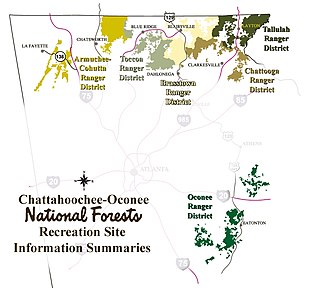
The Armuchee-Cohutta Ranger District is one of the five ranger districts of the Chattahoochee National Forest. Armuchee is thought to be derived from the Cherokee word for "hominy," to be derived from the Choctaw word alurnushi, meaning "hiding place" or mean the "land of the flowers." Cohutta is derived from the Cherokee word cohutta, which means "frog" or could mean "a shed roof supported on poles." The district is spread through portions of Catoosa, Chattooga, Fannin, Floyd, Gilmer, Gordon, Murray, Walker and Whitfield Counties in Georgia. Some of the features within the borders of the district are the Big Frog Wilderness, the Cohutta Wilderness and the Rich Mountain Wilderness.
Chattahoochee Technical College is a public technical college in the U.S. state of Georgia. It is governed by the Technical College System of Georgia and has eight campuses in the north-northwest metro-Atlanta area, and another just outside the region. It is accredited by the Southern Association of Colleges and Schools Commission on Colleges (SACS) to award technical certificates of credit, diplomas, and associate degrees. The college was formed in 2009 as the result of the merger of Appalachian Technical College, Chattahoochee Technical College, and North Metro Technical College.
Georgia Northwestern Technical College (GNTC) is a technical college serving nine counties across northwestern Georgia. It is a member of Georgia's system of technical colleges that operate under the Technical College System of Georgia (TCSG) and an institution of higher learning that provides occupational education, skills training, and workforce development to support the educational, economic, and community development at its six campuses in Catoosa County campus, Walker County Campus, Floyd County Campus, Gordon County Campus, Polk County Campus, and Whitfield-Murray Campus.

The waterfalls of northern Georgia, U.S., are a prominent feature of the geography of that region, as well as a major focus of tourism and outdoor recreation. Many are located in state parks, national forests, wildlife management areas, and other public lands. Many are accessible—with varying degrees of ease or difficulty—via established hiking trails, and some developed areas include boardwalks, observation platforms, picnic areas, and other amenities. The Cherokee called this region "Land of a Thousand Waterfalls". The third-, fourth-, and fifth-highest waterfalls in the eastern United States are located in northern Georgia.
Panther Creek Falls Trail is an interior hiking trail in Georgia's Cohutta Mountains, in Fannin County, northwest of Ellijay, at the southern end of the Smoky Mountains. The trail falls within the 35,000-acre Cohutta Wilderness, part of the Wilderness's 87 mile (140 km) trail system. As an interior trail, Panther Creek Falls cannot be accessed by road, but only via other hiking trails. Eastern access is via the East Cowpen Trail, and its western access via the Conasauga River Trail. The trail starts at the confluence of Panther Creek and the Conasauga River.
Grassy Mountain may refer to
Sawnee Mountain is a low mountain between the piedmont and Appalachian foothills of the U.S. state of Georgia, north of Atlanta. Average rainfall/46.26in/yr/ average snowfall/5.7in/yr/. The name Sawnee Mountain actually refers to the entire ridge of approximately five miles (8 km) in length. At its summit, the elevation is 1,946 feet (593 m) above mean sea level, and is roughly 750 feet (230 m) above the surrounding terrain. The Sawnee Mountain range runs southwest to northeast, and consists of five knolls and three gaps. Located only a few miles north of Cumming, Georgia, the mountain is easily the highest point in Forsyth county. One of the highest peaks of metro Atlanta, it nudges out its prominently known neighbors Stone Mountain and Kennesaw Mountain by a hundred or so feet each. However, Sawnee is in the far northern exurbs, putting it in third place behind Bear Mountain and Pine Log Mountain to the west.

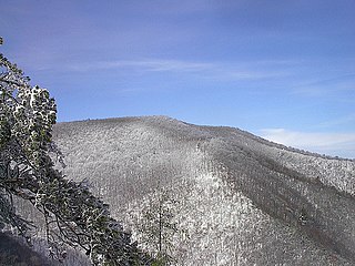
Grassy Mountain is a summit in Murray County, Georgia. At its highest point, the mountain has an elevation of 3,694 feet (1,126 m). It is the second tallest peak in Murray County, if using a 100 feet prominence rule, behind nearby Bald Mountain.
