Landover, Maryland

Last updated

Landover, Maryland
USA Maryland location map.svg
Red pog.svg
Landover
Location within the State of Maryland
Usa edcp location map.svg
Red pog.svg
Landover
Landover (the United States)
Coordinates: 38°56′N76°54′W / 38.933°N 76.900°W / 38.933; -76.900
Country Flag of the United States.svg United States
State Flag of Maryland.svg  Maryland
County Flag of Prince George's County, Maryland (1963-present).svg Prince George's
Area
[1]
  Total4.00 sq mi (10.37 km2)
  Land4.00 sq mi (10.36 km2)
  Water0.01 sq mi (0.01 km2)
Population
 (2020)
  Total25,998
  Density6,499.50/sq mi (2,509.46/km2)
Time zone UTC−5 (Eastern (EST))
  Summer (DST) UTC−4 (EDT)
ZIP Code
20785
Area code(s) 301, 240
FIPS code 24-45325
GNIS feature ID597655

Landover is an unincorporated community and census-designated place in Prince George's County, Maryland, United States. [2] As of the 2020 census, it had a population of 25,998. [3]

Contents

Landover is contained between Sheriff Road and Central Avenue to the south, Hill Road, Cabin Branch Drive, and the Washington Metropolitan Area Transit Authority (Metro) Orange Line tracks to the west, John Hanson Highway (U.S. Highway 50) to the north, and Washington D.C.'s Capital Beltway (Interstate 495/95) to the east. Landover borders the communities of New Carrollton, Landover Hills, Glenarden, Lanham, Ardmore, Kentland, Cheverly, Chapel Oaks, Fairmount Heights, Carmody Hills, Pepper Mill Village, Walker Mill, and Largo.

History

Landover was named after the town of Llandovery, Wales. [4]

The former CDPs of Landover, Dodge Park, Kentland, and Palmer Park, defined as such by the U.S. Census Bureau in the 1990 U.S. Census, [5] were consolidated into the Greater Landover CDP as of the 2000 U.S. Census. [6] This amalgamated area was renamed the Landover CDP as of the 2010 U.S. Census. [7]

Demographics

Historical population
CensusPop.Note
1970 5,597
1980 5,374−4.0%
1990 5,052−6.0%
2010 23,078
2020 25,99812.7%
U.S. Decennial Census [8]
2010 [9] 2020 [10]
Not enumerated separately in 2000 when it was
merged with Dodge Park, Palmer Park
and Kentland to form Greater Landover

2020 census

Landover CDP, Maryland – Racial and ethnic composition
Note: the US Census treats Hispanic/Latino as an ethnic category. This table excludes Latinos from the racial categories and assigns them to a separate category. Hispanics/Latinos may be of any race.
Race / Ethnicity (NH = Non-Hispanic)Pop 2010 [9] Pop 2020 [10] % 2010% 2020
White alone (NH)4506061.95%2.33%
Black or African American alone (NH)18,67116,64780.90%64.03%
Native American or Alaska Native alone (NH)59340.26%0.13%
Asian alone (NH)1516690.65%2.57%
Pacific Islander alone (NH)7130.03%0.05%
Some Other Race alone (NH)451720.19%0.66%
Mixed Race or Multi-Racial (NH)3367261.46%2.79%
Hispanic or Latino (any race)3,3597,13114.55%27.43%
Total23,07825,998100.00%100.00%

Geography

Landover is located at 38°55′26″N76°53′17″W / 38.924°N 76.888°W / 38.924; -76.888 . According to the U.S. Census Bureau, it has an area of 4.07 square miles (10.55 km2), of which 0.004 square miles (0.01 km2), or 0.13%, is water. [11] Landover residents have the postal zipcode of 20785. Since Landover is an unincorporated community in Prince George's County, residents of Landover have Hyattsville postal addresses though they live in Landover and not Hyattsville. Landover does not have its own postal zipcode.

Landover consists of several small subdivisions which are notably Ardwick Park, Kentland, Kenmoor, Dodge Park, Brightseat, Palmer Park, Columbia Park, Village Green, White House Heights, and Summerfield. Landover is home to FedExField, which the NFL's Washington Commanders have played at since it opened in 1997. It is also home to the Prince George's Sports & Learning Complex, WMATA's Landover Metrobus Division, WMATA's Carmen E. Turner Maintenance Facility, Giant Food Corporate Office, Giant Food Corporate Plant, National Harmony Memorial Park Cemetery, and Ardwick Industrial Park. WMATA Metrorail's Orange Line from New Carrollton to Vienna, MARC train Line to the BWI Light Rail Station to Washington D.C.'s Union Station, Cargo Trains, and Amtrak's Train Line from Washington D.C.'s Union Station to New York's Penn Station via Wilmington and Philadelphia, all go through Landover. Landover Hills is a separate, incorporated community just across the Orange Line train tracks and John Hanson Highway (U.S. Highway 50) to the north. Landover is the birthplace of the late Len Bias. From 1960 to 1972, Landover was the home of jazz guitarist, composer, arranger, author, and jazz educator Steve Rochinski.

For the 2000 census, Landover was delineated by the U.S. Census Bureau as the Greater Landover census-designated place.

Economy

Eight O'Clock Coffee's coffee production plant is located in Landover. Giant Food has its headquarters in a location in unincorporated Prince George's County in the Ardwick Industrial Park area, near Landover. [12] The Giant Food Headquarters is located next to the New Carrollton Metro Station. It is served by the F13 metrobus shuttle that goes from the Cheverly Metro station to Washington Business Park.

Arts and culture

Beall's Pleasure and Ridgley Methodist Episcopal Church are listed on the National Register of Historic Places. [13] A Harlem Renaissance Festival occurs at Kentland-Columbia Park Community Center in Landover every year in May. [14] In 2014, the National Archives for Black Women's History was controversially relocated from Washington, D.C., to 3300 Hubbard Road in Landover. [15] [16]

Sports

FedExField, the home field of the NFL's Washington Commanders. FedexField photo by Flickr user dbking.jpg
FedExField, the home field of the NFL's Washington Commanders.

FedExField is a football stadium for the Washington Commanders of the National Football League in the neighboring CDP of Summerfield and has a Landover postal address. [17] [18] (See also Raljon, Maryland.) The Washington Wizards and Washington Capitals used to play in Landover's Capital Centre (later known as the US Airways Arena) before moving to the Capital One Arena, inside D.C itself. The arena was demolished in 2002. [19]

The Prince George's Sports & Learning Complex is also in Summerfield CDP, [20] located on approximately 80 acres (320,000 m2) adjacent to FedExField. [21]

Government

Prince George's County Police Department headquarters, which is also District 3 Station, [22] [23] is in the Palmer Park area in Landover CDP. [5] [7]

The U.S. Postal Service operates the Landover Post Office in the CDP. [7] [24]

Education

Public education

Landover is a part of the Prince George's County Public Schools system. [7]

Elementary schools serving sections of the Landover CDP include: Columbia Park, Dodge Park, Cooper Lane, Gladys Noon Spellman, Highland Park, and William Paca. [25] Middle schools serving sections of the Landover CDP include: G. James Gholson, Kenmoor, and Charles Carroll. [26] Senior high schools serving sections of the Landover CDP include: Fairmont Heights, Charles Herbert Flowers, DuVal, and Bladensburg. [27] The schools serving the 1990 CDP are: [28] Cooper Lane and Gladys Noon Spellman elementaries, [25] Charles Carroll Middle, [26] and Bladensburg High. [27]

When desegregation busing began in 1972, PG County school officials bused many black children in Landover to schools with large numbers of white students in other areas of the county. Since then many schools in the Landover area had closed. David Nakamura of The Washington Post stated that many Landover residents believed that desegregation busing contributed to the socioeconomic decline of Landover. In 1998 the busing program was abolished due to a settlement in federal court. [29]

Matthew Henson Elementary School was previously in the CDP. [30] It was scheduled to close in 2009. [31] In 2012 EXCEL Academy agreed to open a charter school in the former Henson space, [32] and it moved from its previous campus in Riverdale. [33]

Other area schools:

Colleges and universities

Landover had career-based colleges, such as Fortis College, [34] that offer programs including bio-technician, medical assisting, and medical coding and billing.

Infrastructure

Transportation

Landover station, located off MD 202 Landover station exterior.jpg
Landover station, located off MD 202

Landover is one of the few regions in the Washington, D.C. area that is served directly by multiple separate Washington Metro rail lines. Landover is served by the Orange, Blue, and Silver lines (many DC area suburbs are not served directly by Metrorail at all). The Landover Metro station serves the northern portion of Landover on the Orange Line. This station is also the primary metro station that serves the Landover area. The Morgan Boulevard Metro station, constructed in 2004, serves the southern portion of Landover on the Blue and Silver Lines and is the main rail terminus providing access to FedExField, which is home to the Washington Commanders in addition to many other sporting and entertainment events. Landover also has a special Metrobus Division also houses many Metrobuses that serve routes in Prince George's County, Maryland.

In addition to the Landover and Morgan Boulevard Metro Stations that primarily serve the Landover area, Landover residents have access to other metro stations nearby, such as New Carrollton, Cheverly, Downtown Largo, and Addison Road-Seat Pleasant.

I-495/95, the Capital Beltway, crosses U.S. Route 50 in Landover. The Beltway also has junctions with Maryland Route 202 (Landover Road) and Brightseat Road, which leads directly to FedExField.

Shopping

Landover was the home of Landover Mall, owned and operated by Lerner Enterprises. Built in 1972, it was the first enclosed mall in the Washington, D.C. metropolitan area to house four high-end retail anchor stores: Garfinkel's, Hecht's (owned by the May company), Woodward and Lothrop (popularly known as Woodies), and Sears. The mall also housed a multiplex movie theater located in the basement of the northeast corridor of the building. Located at the Capital Beltway and Landover Road, the mall neighbored the towns of Palmer Park, Ardmore, Glenarden, and Largo. Palmer Park was the hometown of Olympic boxing champion Sugar Ray Leonard. [35] Garfinkel's closed in 1990, Woodies closed in 1995 and was replaced with a J.C. Penney store that lasted from 1996 to 2001, and Hecht's closed in 2002 with the opening of the Bowie Town Center located in Bowie. The entire mall officially closed in 2003 and was demolished in 2006, with the exception of Sears. Sears closed in 2014 and was later demolished.

With the arrival in 1997 of FedExField, the mall's parking lot is used for overflow parking. In 2007, according to The Washington Post, [36] Prince George's County officials were in the midst of developing plans to transform the area where Landover Mall once stood. County officials propose to build luxury townhouses, trendy stores, and office buildings. The goal of the project is to transform the area into a residential and cultural hub that replicates the Bowie Town Center, and The Boulevard at the Capital Centre; the latter is in Lake Arbor CDP and has a Largo postal address. [37] [38]

Parks and recreation

The Prince George's County Department of Parks and Recreation operates the Kentland Community Center and the Palmer Park Community Center. [39] [40]

Related Research Articles

<span class="mw-page-title-main">Brandywine, Maryland</span> Census-designated place in Maryland

Brandywine is the name of an unincorporated area in Prince George's County, Maryland, United States, that refers both to a census-designated place (CDP) and a zip code area which is much larger (20613), whose areas overlap. The population of Brandywine at the 2020 U.S. Census was 10,550 for the CDP, and the population of ZIP code 20613 was 11,860 in 2010.

<span class="mw-page-title-main">Cheverly, Maryland</span> Town in Prince Georges County, Maryland, US

Cheverly is a town in Prince George's County, Maryland, United States, located very close to Washington, D.C., though not bordering it directly. The town was founded in 1918 and incorporated in 1931. Per the 2020 census, the population was 6,170. Cheverly borders the communities of Tuxedo, Chapel Oaks, Landover, Landover Hills, Villa Heights, and Bladensburg.

<span class="mw-page-title-main">Chillum, Maryland</span> Census-designated place in Maryland

Chillum is an unincorporated area and census-designated place in Prince George's County, Maryland, United States, bordering Washington, D.C., and Montgomery County.

<span class="mw-page-title-main">Fairmount Heights, Maryland</span> Historic district in Maryland, United States

Fairmount Heights is a town in Prince George's County, Maryland, United States. Per the 2020 census, the population was 1,528. The town was formally incorporated in 1935, making the town the second oldest African-American-majority municipality in Prince George's County. The town is composed of six subdivisions: Fairmount Heights (1900), Waterford (1907), Mount Weissner (1909), North Fairmount Heights (1910), West Fairmount Heights (1911) and Sylvan Vista (1923).

<span class="mw-page-title-main">Forestville, Maryland</span> CDP in Maryland

Forestville is an unincorporated area and census-designated place (CDP) in Prince George's County, Maryland, United States. Per the 2020 census, the population was 12,831. The community is a mixture of garden apartments, single-family homes, and shopping centers built mostly from the 1930s through 1970s, adjacent to the communities of District Heights, Suitland, Morningside, Westphalia and Camp Springs.

<span class="mw-page-title-main">Glenarden, Maryland</span> City in Maryland, United States

Glenarden is a city in Prince George's County, Maryland, United States. Per the 2020 census, the population was 6,402.

<span class="mw-page-title-main">Greater Landover, Maryland</span> Former census-designated place in Maryland, United States

Greater Landover was a census-designated place (CDP) in Prince George's County, Maryland, during the 2000 United States Census. The population was 22,900 at that time. As of 2007, the rough estimate given by the census was at 22,665. For the 2010 U.S. Census, the area was designated the Landover CDP.

<span class="mw-page-title-main">Largo, Maryland</span> Census-designated place in Maryland, United States

Largo, located within Greater Upper Marlboro, Maryland, is an unincorporated area and census-designated place in Prince George's County, Maryland, United States. The population was 11,605 at the 2020 census.

<span class="mw-page-title-main">Marlow Heights, Maryland</span> Census-designated place in Maryland, United States

Marlow Heights is an unincorporated area and census-designated place (CDP) in Prince George's County, Maryland, United States. The population was 6,169 at the 2020 census. The Marlow Heights Shopping Center first opened in 1957, adjacent to the large community of Hillcrest Heights. It was joined ten years later, in 1967, by the two-level Iverson Mall, the Washington metropolitan area's first enclosed mall.

<span class="mw-page-title-main">Seat Pleasant, Maryland</span> City in Maryland

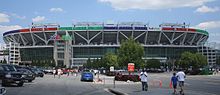
Seat Pleasant is an incorporated city in Prince George's County, Maryland, United States, located immediately east of Washington D.C.. Per the 2020 census, the population was 4,522. Two state highways pass through the community — Maryland routes 704 and 214. The Washington Metro's Blue and Silver Lines are nearby. The Washington Commanders' stadium is east of Seat Pleasant, near the Capital Beltway (I-95/495).

Lanham is an unincorporated community and census-designated place in Prince George's County, Maryland. As of the 2020 United States Census it had a population of 11,282. The New Carrollton station as well as an Amtrak station are across the Capital Beltway in New Carrollton, Maryland. Doctors Community Hospital is located in Lanham.

<span class="mw-page-title-main">Morgan Boulevard station</span> Washington Metro station

Morgan Boulevard station is an island-platformed Washington Metro station in Summerfield, Prince George's County, Maryland, United States, with a Landover postal address. The station was opened on December 18, 2004, and is operated by the Washington Metropolitan Area Transit Authority (WMATA). It provides service for the Blue and Silver Lines.

<span class="mw-page-title-main">Suitland, Maryland</span> Census-designated place in Maryland, United States

Suitland is a suburb of Prince George's County, Maryland, approximately one mile (1.6 km) southeast of Washington, D.C. Suitland is a census designated place (CDP), as of the 2020 census, its population was 25,839. Prior to 2010, it was part of the Suitland-Silver Hill census-designated place.

<span class="mw-page-title-main">Kentland, Maryland</span> Unincorporated community in Maryland

Kentland is an unincorporated community and former census-designated place in Prince George's County, Maryland, United States, located within the Landover census area. Kentland is served by the Landover Metro Station, which is located just north of the community, across Landover Road.

Palmer Park is an unincorporated community in Prince George's County, Maryland, United States, within the census-designated place of Landover. It was previously a CDP of its own until 2000.

<span class="mw-page-title-main">Charles Herbert Flowers High School</span> Public high school in United States

Charles Herbert Flowers High School is a comprehensive science and technology magnet school located in unincorporated Prince George's County, Maryland, United States, adjacent to the Springdale census-designated place and with a Springdale postal address. It is part of the Prince George's County School System. Its principal is Dr. Gorman Brown.

<span class="mw-page-title-main">Fairmont Heights High School</span> Public comprehensive secondary school in Landover, Maryland , United States

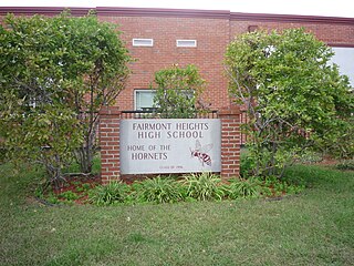
Fairmont Heights High School (est.1950) is an American public comprehensive secondary school located in Landover, Maryland, just outside Washington D.C. It is part of the Prince George's County Public Schools system. Two middle schools feed into Fairmont Heights. It is part of the School Board District 3.

Summerfield is a census-designated place near Landover in Prince George's County, Maryland. As of the 2020 census, the population was 14,758. It is a suburb of Washington, D.C.

Dodge Park is an unincorporated area and former census-designated place (CDP) in Prince George's County, Maryland, United States; it is currently within the Landover CDP.

Brown Station is an census designated place in Prince George's County, Maryland, United States. Per the 2020 Census, the population was 3,298.

References

  1. "2020 U.S. Gazetteer Files". United States Census Bureau. Retrieved April 26, 2022.
  2. "Landover". Geographic Names Information System . United States Geological Survey, United States Department of the Interior.
  3. "Landover CDP, Maryland". United States Census Bureau . Retrieved March 13, 2022.
  4. "Profile for Landover, Maryland, MD". ePodunk. Archived from the original on February 10, 2013. Retrieved August 25, 2012.
  5. 1 2 "1990 COUNTY BLOCK MAP" (index map) Prince George's County. U.S. Census Bureau. Retrieved on September 9, 2018. The CDPs of Landover, Dodge Park, Kentland, and Palmer Park are shown on pages 13, 14, 17, and 18.
  6. "CENSUS 2000 BLOCK MAP: GREATER LANDOVER CDP." U.S. Census Bureau. Retrieved on September 9, 2018.
  7. 1 2 3 4 "2010 CENSUS - CENSUS BLOCK MAP: Landover CDP, MD." U.S. Census Bureau. Retrieved on September 1, 2018.
  8. "Decennial Census of Population and Housing by Decades". US Census Bureau.
  9. 1 2 "P2 Hispanic or Latino, and Not Hispanic or Latino by Race – 2010: DEC Redistricting Data (PL 94-171) - Landover CDP, Maryland". United States Census Bureau .
  10. 1 2 "P2 Hispanic or Latino, and Not Hispanic or Latino by Race – 2020: DEC Redistricting Data (PL 94-171) - Landover CDP, Maryland". United States Census Bureau .
  11. "Geographic Identifiers: 2010 Demographic Profile Data (G001): Landover CDP, Maryland". United States Census Bureau . Retrieved December 20, 2011.
  12. "Facility Locations". Giant Food. Retrieved on September 6, 2011. "8301 Professional Place, Suite 115 Landover, MD 20785."
  13. "National Register Information System". National Register of Historic Places . National Park Service. July 9, 2010.
  14. "Harlem Renaissance Festival". Festival Media Corporation. Retrieved August 24, 2012.
  15. "National Park Service to go ahead with moving archives from Bethune house - The Washington Post". The Washington Post . November 19, 2019. Archived from the original on November 19, 2019. Retrieved November 20, 2019.
  16. "National Archives for Black Women's History - Mary McLeod Bethune Council House National Historic Site (U.S. National Park Service)". October 22, 2019. Archived from the original on October 22, 2019. Retrieved November 20, 2019.
  17. "2010 CENSUS - CENSUS BLOCK MAP: Summerfield CDP, MD" (PDF). U.S. Census Bureau . Retrieved September 7, 2018.
  18. "FedExField." State of Maryland Office of Tourism Development. Retrieved on September 7, 2018. "1600 FedEx Way, Landover, MD 20785" - See also parking map from Washington Commanders website
  19. "Flashback: Before the Capitals, and the birth of the Cap Centre". April 26, 2017.
  20. "Fedexfield Parking and Directions." Washington Commanders. Retrieved on September 7, 2018. "[...]Prince George’s County Sports Complex located at 8001 Sheriff Rd, Hyattsville MD 20785."
  21. Prince George's Sports & Learning Complex
  22. "Winter/Spring PAL Basketball Clinic." Government of Prince George's County. Retrieved on September 20, 2018. "Location: Police Headquarters Address: 7600 Barlowe Road Landover, MD 20785 "
  23. "District 3 Station - Landover." Prince George's County Police Department. Retrieved on September 9, 2018. " 7600 Barlowe Road Landover, MD 20785 ". Beat map
  24. "LANDOVER." U.S. Postal Service. Retrieved on September 11, 2018. "3312 DODGE PARK RD HYATTSVILLE, MD 20785-9997"
  25. 1 2 "NEIGHBORHOOD ELEMENTARY SCHOOLS AND BOUNDARIES SCHOOL YEAR 2018-2019." Prince George's County Public Schools. Retrieved on September 1, 2018.
  26. 1 2 "NEIGHBORHOOD MIDDLE SCHOOLS AND BOUNDARIES SCHOOL YEAR 2018-2019." Prince George's County Public Schools. Retrieved on September 1, 2018.
  27. 1 2 "NEIGHBORHOOD HIGH SCHOOLS AND BOUNDARIES SCHOOL YEAR 2018-2019." Prince George's County Public Schools. Retrieved on September 1, 2018.
  28. "1990 COUNTY BLOCK MAP" (index map) Prince George's County. U.S. Census Bureau. Retrieved on September 9, 2018. Landover CDP is shown on page 13.
  29. Nakamura, David (February 27, 2000). "Pr. George's School Splits the Classes". The Washington Post . Retrieved September 2, 2018.
  30. Home page. Matthew Henson Elementary School. May 16, 2001. Retrieved on September 7, 2018. "Matthew Henson Elementary/Montessori School 7910 Scott Road Landover, Maryland 20785"
  31. 1 2 Preliminary Subregion 4 Master Plan and Proposed Sectional Map Amendment. Maryland-National Capital Park and Planning Commission. Chapter 9, Public Facilities. p. 261 (PDF p. 3/28). Retrieved on September 7, 2018.
  32. Brownback, Abby (May 21, 2012). "Riverdale charter school to move into vacant Landover elementary building". The Gazette . Archived from the original on September 7, 2018. Retrieved September 7, 2018.
  33. Leaderman, Daniel (August 19, 2010). "New principal of Riverdale charter school wants to build strong community ties". The Gazette . Archived from the original on September 7, 2018. Retrieved September 7, 2018.
  34. Fortis College - Landover
  35. In the late 1980s, crime began to rise in the surrounding areas and frightened shoppers eventually helped fuel the mall's rapid decline. The movie theater was the first to close, followed by three of the mall's anchor stores in the 1990s.
  36. Ovetta Wiggins (July 9, 2007). "Landover May Be Next On Revival Bandwagon". The Washington Post . Retrieved May 27, 2015.
  37. "2010 CENSUS - CENSUS BLOCK MAP (INDEX): Lake Arbor CDP, MD." U.S. Census Bureau. Retrieved on September 1, 2018. Pages: 1 and 2.
  38. Contact Us." The Boulevard at the Capital Centre. Retrieved on September 9, 2018. "Boulevard at the Capital Centre 900 Capital Centre Boulevard Largo, MD 20774"
  39. "Kentland Community Center." Prince George's County Department of Parks and Recreation. Retrieved on September 20, 2018. "Kentland Community Center 2413 Pinebrook Avenue Landover, MD 20785"
  40. "Palmer Park Community Center." Prince George's County Department of Parks and Recreation. Retrieved on September 20, 2018. "Palmer Park Community Center 7720 Barlowe Road Landover, MD 20785"