
Prince George's County is located in the U.S. state of Maryland, bordering the eastern portion of Washington, D.C. As of the 2010 U.S. Census, the population was 863,420, making it the second-most populous county in Maryland, behind Montgomery County. Its county seat is Upper Marlboro. It is one of the richest African American-majority counties in the United States, with five of its communities identified in a 2015 top ten list.

Bowie is a city in Prince George's County, Maryland, United States. The population was 54,727 at the 2010 U.S. Census. Bowie has grown from a small railroad stop to the largest municipality in Prince George's County, and the fifth most populous city and third largest city by area in the U.S. state of Maryland. In 2014, CNN Money ranked Bowie 28th in its Best Places to Live in America list.

Brandywine is the name of an unincorporated area in Prince George's County, Maryland, United States, that refers both to a census-designated place (CDP) and a zip code area which is much larger (20613), whose areas overlap. The population of Brandywine at the 2010 U.S. Census was 6,719 for the CDP, and the population of ZIP code 20613 was 11,860 in 2010.

Hillcrest Heights is an unincorporated area and census-designated place (CDP) in Prince George's County, Maryland, United States, with an African-American majority population. The population was 16,469 at the 2010 census. For mailing address purposes, it is part of the smaller community of Temple Hills and is also near Suitland. It is also the birthplace of former San Francisco 49ers, Seattle Seahawks and Detroit Lions linebacker, Julian Peterson.

Hyattsville is a city in Prince George's County, Maryland, United States, and also a close, urban suburb of Washington. The population was 17,557 at the 2010 United States Census.

Upper Marlboro, officially the Town of Upper Marlboro, is the seat of Prince George's County, Maryland, United States. The population within the town limits was 631 at the 2010 U.S. Census, although Greater Upper Marlboro is many times larger.

Lanham is an unincorporated community and census-designated place in Prince George's County, Maryland, United States. As of the 2010 United States Census it had a population of 10,157. The New Carrollton station as well as an Amtrak station are across the Capital Beltway in New Carrollton, Maryland. Doctors Community Hospital is located in Lanham.
Peppermill Village is an unincorporated community near Maryland Route 214 in Prince George's County, Maryland, United States. The Washington Redskins football stadium, Metrorail's Blue Line, and Hampton Mall shopping center are all located nearby. Because it is not formally incorporated, it has no official boundaries, but the United States Census Bureau has defined a census-designated place (CDP) consisting of Peppermill Village and the adjacent community of Carmody Hills, for statistical purposes.

Douglas J. J. Peters is an American politician from Maryland and a member of the Democratic Party. He is currently serving in the Maryland State Senate, representing the 23rd district in Prince George's County since January 10, 2007.

The Prince George's County Police Department (PGPD) is the primary law enforcement agency in Prince George's County, Maryland in the United States, servicing a population of over 900,000 residents and visitors within 498 square miles (1,290 km²) of jurisdiction.
Konterra is an unincorporated area and census-designated place (CDP) in Prince George's County, Maryland, United States. The population was 2,527 at the 2010 census.
Vansville is an unincorporated community in Prince George's County, Maryland, United States. For statistical purposes, it is part of the Beltsville census-designated place (CDP).
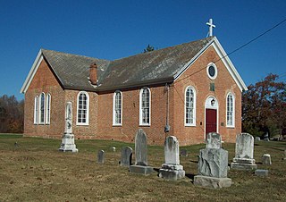
St. Paul's Church, also known as St. Paul's Church, Baden, or St. Paul's Parish, Prince George's County, is located at 13500 Baden-Westwood Road, in Baden, a community near Brandywine in Prince George's County, Maryland. It was originally constructed in 1733–1735. A porch on the north side was enclosed in 1769, and in 1793 an addition of 26 by 30 feet was made to the south side. The Bishop's Window, a memorial to Bishop Thomas John Claggett, is at the chancel window. In 1921 the sanctuary was widened and the chancel deepened.

This is a list of the National Register of Historic Places listings in Prince George's County, Maryland.

Croom is an unincorporated community and census-designated place in Prince George's County, Maryland, United States. As of the 2010 census it had a population of 2,631. Croom largely consists of former tobacco farms and forests converted to Washington bedroom subdivisions such as nearby Marlton. The main part of Patuxent River Park is in Croom.
Danville is an unincorporated community in Prince George's County, Maryland, United States. It is located within the Brandywine mailing address, and consists of only farms, with no businesses, and a very small housing development which was begun in 2009.
Fairwood is an unincorporated area and census-designated place (CDP) in Prince George's County, Maryland, United States. The population was 5,031 at the 2010 census.
Good Luck is a ghost town and former census-designated place in Prince George's County, Maryland, United States.
Tantallon is an unincorporated community in Prince George's County, Maryland, United States. Although a separate community, it is a part of the census-designated place (CDP) of Fort Washington. The ZIP code for the community is 20744. Tantallon reported as a census-designated place by the U.S. Census Bureau in 1980, which included much of the northern half of Fort Washington's census area. The population recorded was 9,945.
Orme is an unincorporated community in Prince George's County. Maryland, United States.

