University Park, Maryland

Last updated

University Park, Maryland
Town of University Park
UniversityParkMDTownHall.JPG
The University Park Town Hall, in July 2010, at 6724 Baltimore Avenue.
Flag of University Park, Maryland.png
University Park MD Town Seal.png
Prince George's County Maryland Incorporated and Unincorporated areas University Park Highlighted.svg
Location of University Park, Maryland
Coordinates: 38°58′17″N76°56′36″W / 38.97139°N 76.94333°W / 38.97139; -76.94333
Country Flag of the United States.svg United States of America
State Flag of Maryland.svg  Maryland
County Flag of Prince George's County, Maryland (1963-present).svg Prince George's
Incorporated 1936 [1]
Area
[2]
  Total0.50 sq mi (1.30 km2)
  Land0.50 sq mi (1.30 km2)
  Water0.00 sq mi (0.00 km2)
Elevation
72 ft (22 m)
Population
 (2020)
  Total2,454
  Density4,898.20/sq mi (1,889.34/km2)
Time zone UTC-5 (Eastern (EST))
  Summer (DST) UTC-4 (EDT)
ZIP code
20782
Area code(s) 301, 240
FIPS code 24-79675
GNIS feature ID0598206
Website www.upmd.org

University Park is a town in Prince George's County, Maryland, United States. [3] The population was 2,454 at the 2020 census. [4]

Contents

History

Bloomfield (Deakins House) in November 2008 Bloomfield Nov 08.JPG
Bloomfield (Deakins House) in November 2008

University Park was developed on land owned by the Deakins family since the mid-1700s. The house known as Deakins Hall or Bloomfield was constructed on the land in the 1820s or 1830s. It is located at 6404 Queens Chapel Road. The farm was purchased by the University Park Company in 1923. The extension of water and sewer lines into area at that time prompted the subdivision of the Deakins tract. The developers promised a community of single-family homes without the intrusion of commercial facilities. Restrictive covenants were placed on the deeds and all house plans had to be approved by the developers. Homebuyers were attracted to University Park due to its high elevation and lush vegetation. The developers also agreed to provide streetlights and trash removal for a 10-year period, and constructed a school in the mid-1920s. [5]

The town was incorporated in 1936, and the current town hall is located at 6724 Baltimore Avenue, on U.S. Route 1.

By 1940, the community had grown to 293 houses. The size of the town nearly doubled between 1940 and 1950, with the construction of another 255 houses. Houses constructed during these periods include brick and wood-frame Bungalow style and revival-style structures. The last building boom occurred in the late 1950s with the construction of 300 brick ranches. [5]

Community facilities include a police department, started in 1965, a school, and a community park. The two-room company school built in the mid-1920s was converted to a residence after the county constructed a new school building in 1928, which was replaced in 1978 with a modern facility. The town park was purchased in 1941, though its development was postponed by World War II. It was designed and developed in the early 1950s to include a sunken garden, trails, playground, tennis courts, and picnic area. The town remains without commercial properties. [5]

The University Park Historic District, a national historic district on the National Register of Historic Places, was listed in 1997. [6] Residents who own homes that are "contributing structures" to the University Park Historic District may participate in the Heritage Preservation Tax Credit Program, administered through the Maryland Historical Trust. Participants in this program receive a tax credit for a portion of the cost of certified work that maintains or rehabilitates the contributing structures. One such structure identified by the Maryland-National Capital Park and Planning Commission is Bloomfield. [7]

September 11 attacks

University Park lost five of its residents in the September 11 attacks: The Falkenberg/Whittington family – Charles, Zoe, and Dana Falkenberg and Leslie Whittington, died on September 11 aboard American Airlines Flight 77, which crashed into the Pentagon during a flight from Dulles International Airport to Los Angeles International Airport. They were headed to Australia for a two-month stay. [8] Sheila Hein died when Flight 77 crashed into the Pentagon, in which she worked. [9]

Geography

University Park is located at 38°58′17″N76°56′36″W / 38.97139°N 76.94333°W / 38.97139; -76.94333 (38.971381, −76.943399). [10]

According to the United States Census Bureau, the town has a total area of 0.50 square miles (1.29 km2), all land. [11]

University Park is bordered on the north by the city of College Park, to the south and east by the city of Riverdale Park, to the south and west by the town of Hyattsville, and is bordered in several directions by certain unincorporated parts of Prince George's County, such as Adelphi.

The town includes a public park and a portion of Wells Run, a small tributary of the Northeast Branch of the Anacostia River.

Government

The town was incorporated in 1936 and has expanded several times since then. The town has its own town council, police department, and sanitation services.

The current mayor of University Park is Joel Biermann. The Chief of Police is Harvey Baker, appointed by the mayor with approval of the town council.

University Park is served by several voluntary organizations, including the University Park Civic Association (UPCA), the University Park Women's Club (UPWC), and the Lewisdale-University Park Boys and Girls Club (LUP).

Law enforcement

Prince George's County Police Department District 1 Station in Hyattsville serves University Park. [12]

In addition to the Prince George's County Police Department, the town is serviced by the University Park Police Department (UPPD). The UPPD was created in 1962 with a single officer acting as chief and patrolman. The UPPD currently has an authorized force of eight certified, sworn officers that provided 24-hour service to a population of over 2,300 within the municipality and adjoining streets and roadways. The UPPD provides vehicular, foot, and bicycle patrol and is aided by the Prince George's County Police and Sheriff's Office for other incidents deemed appropriate by authority. [13]

Transportation

MD 410 eastbound on the south edge of University Park 2019-06-12 10 38 26 View east along Maryland State Route 410 (East-West Highway) at Maryland State Route 500 (Queens Chapel Road) on the border of University Park and Hyattsville in Prince George's County, Maryland.jpg
MD 410 eastbound on the south edge of University Park

The only state highway directly serving University Park is Maryland Route 410, the East-West Highway. MD 410 serves as a local connector route linking the inner suburbs on the northern and northeastern sides of Washington, D.C. together. Just outside the town limits, MD 410 has junctions with U.S. Route 1 and Maryland Route 500, both of which connect directly to Washington D.C. US 1 also connects with the nearest interstate highways, Interstate 95 and Interstate 495 (the Capital Beltway).

Education

University Park is served by Prince George's County Public Schools: [14] zoned schools are University Park Elementary School (in University Park), [15] Hyattsville Middle School (in Hyattsville), [16] and Northwestern High School (in Hyattsville). [17]

Many University Park high school students choose to attend Eleanor Roosevelt High School in Greenbelt.[ citation needed ]

Demographics

Historical population
CensusPop.Note
1940 878
1950 2,205151.1%
1960 3,09840.5%
1970 2,926−5.6%
1980 2,536−13.3%
1990 2,243−11.6%
2000 2,3183.3%
2010 2,5489.9%
2020 2,454−3.7%
U.S. Decennial Census [18]

2010 census

As of the census [19] of 2010, there were 2,548 people, 897 households, and 675 families residing in the town. The population density was 5,096.0 inhabitants per square mile (1,967.6/km2). There were 919 housing units at an average density of 1,838.0 per square mile (709.7/km2). The racial makeup of the town was 78.5% White, 9.3% African American, 0.1% Native American, 4.7% Asian, 3.0% from other races, and 4.4% from two or more races. Hispanic or Latino of any race were 11.3% of the population.

There were 897 households, of which 35.1% had children under the age of 18 living with them, 62.8% were married couples living together, 9.1% had a female householder with no husband present, 3.3% had a male householder with no wife present, and 24.7% were non-families. 16.3% of all households were made up of individuals, and 6.4% had someone living alone who was 65 years of age or older. The average household size was 2.84 and the average family size was 3.05.

The median age in the town was 41.5 years. 23.1% of residents were under the age of 18; 8.5% were between the ages of 18 and 24; 23.1% were from 25 to 44; 33.4% were from 45 to 64; and 11.8% were 65 years of age or older. The gender makeup of the town was 50.2% male and 49.8% female.

2000 census

As of the census [20] of 2000, there were 2,318 people, 877 households, and 637 families residing in the town. The population density was 4,677.5 inhabitants per square mile (1,806.0/km2). There were 898 housing units at an average density of 1,812.1 per square mile (699.7/km2). The racial makeup of the town was 85.46% White, 7.29% African American, 0.26% Native American, 3.67% Asian, 1.04% from other races, and 2.29% from two or more races. Hispanic or Latino of any race were 5.57% of the population.

There were 877 households, out of which 33.9% had children under the age of 18 living with them, 61.6% were married couples living together, 8.1% had a female householder with no husband present, and 27.3% were non-families. 20.1% of all households were made up of individuals, and 9.6% had someone living alone who was 65 years of age or older. The average household size was 2.63 and the average family size was 2.99.

In the town, the population was spread out, with 23.9% under the age of 18, 5.7% from 18 to 24, 26.8% from 25 to 44, 28.3% from 45 to 64, and 15.3% who were 65 years of age or older. The median age was 42 years. For every 100 females, there were 96.3 males. For every 100 females age 18 and over, there were 91.8 males.

The median income for a household in the town was $89,450, and the median income for a family was $96,349. Males had a median income of $62,375 versus $43,083 for females. The per capita income for the town was $40,402. About 1.2% of families and 3.5% of the population were below the poverty line, including 2.9% of those under age 18 and 1.4% of those age 65 or over.

Notable people

See also

Related Research Articles

<span class="mw-page-title-main">Prince George's County, Maryland</span> County in Maryland, United States

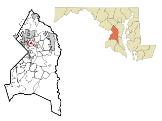
Prince George's County is located in the U.S. state of Maryland bordering the eastern portion of Washington, D.C. As of the 2020 U.S. census, the population was 967,201, making it the second-most populous county in Maryland, behind neighboring Montgomery County. The 2020 census counted an increase of nearly 104,000 in the previous ten years. Its county seat is Upper Marlboro. It is the largest and the second most affluent African American-majority county in the United States, with five of its communities identified in a 2015 top ten list.

<span class="mw-page-title-main">Adelphi, Maryland</span> Census-designated place in Maryland

Adelphi is an unincorporated area and census-designated place in Prince George's County, Maryland, United States. Per the 2020 Census, the population was 16,823. Adelphi includes the following subdivisions; Adelphi, Adelphi Park, Adelphi Hills, Adelphi Terrace, Adelphi Village, Buck Lodge, Chatham, Cool Spring Terrace, Hillandale Forest, Holly Hill Manor, Knollwood, Lewisdale, and White Oak Manor.

<span class="mw-page-title-main">Berwyn Heights, Maryland</span> Town in Maryland

Berwyn Heights is a town in Prince George's County, Maryland, United States. Per the 2020 census, the population was 3,345. It is bordered by College Park to the west, Greenbelt to the northeast, and Riverdale Park to the south.

<span class="mw-page-title-main">Bladensburg, Maryland</span> Town in Maryland, United States

Bladensburg is a town in Prince George's County, Maryland, United States. The population was 9,657 at the 2020 census. Areas in Bladensburg are located within ZIP code 20710. Bladensburg is 8.6 miles (13.8 km) from Washington, D.C.

<span class="mw-page-title-main">Brentwood, Maryland</span> Town in Prince Georges County, Maryland, US

Brentwood is a town in Prince George's County, Maryland, United States. Per the 2020 census, the population was 3,828. Brentwood is located within 1-mile (1.6 km) of Washington. The municipality of Brentwood is located just outside the northeast boundary of the District of Columbia and surrounded by the communities of Mount Rainier, Cottage City, North Brentwood, and the nearby Hyattsville. Along the Route 1 Corridor, Brentwood is part of the Gateway Arts District.

<span class="mw-page-title-main">Cheverly, Maryland</span> Town in Prince Georges County, Maryland, US

Cheverly is a town in Prince George's County, Maryland, United States, located very close to Washington, D.C., though not bordering it directly. The town was founded in 1918 and incorporated in 1931. Per the 2020 census, the population was 6,170. Cheverly borders the communities of Tuxedo, Chapel Oaks, Landover, Landover Hills, Villa Heights, and Bladensburg.

<span class="mw-page-title-main">Chillum, Maryland</span> Census-designated place in Maryland

Chillum is an unincorporated area and census-designated place in Prince George's County, Maryland, United States, bordering Washington, D.C., and Montgomery County.

<span class="mw-page-title-main">Colmar Manor, Maryland</span> Town in Maryland

Colmar Manor is a town located in Prince George's County, Maryland, United States. As of the 2010 census, the town had a population of 1,404. As the town developed at the beginning of the 20th century, it assumed a name derived from its proximity to the District of Columbia—the first syllable of Columbia and that of Maryland were combined to form "Colmar". Colmar Manor was incorporated in 1927.

<span class="mw-page-title-main">Edmonston, Maryland</span> Town in Maryland

Edmonston is a town in Prince George's County, Maryland, United States. As of the 2020 census, the town population was 1,617.

<span class="mw-page-title-main">Fairmount Heights, Maryland</span> Historic district in Maryland, United States

Fairmount Heights is a town in Prince George's County, Maryland, United States. Per the 2020 census, the population was 1,528. The town was formally incorporated in 1935, making the town the second oldest African-American-majority municipality in Prince George's County. The town is composed of six subdivisions: Fairmount Heights (1900), Waterford (1907), Mount Weissner (1909), North Fairmount Heights (1910), West Fairmount Heights (1911) and Sylvan Vista (1923).

<span class="mw-page-title-main">Hyattsville, Maryland</span> City in Maryland

Hyattsville is a city in Prince George's County, Maryland, United States. It is an urban suburb of Washington, D.C. The population was 21,187 at the 2020 United States census.

<span class="mw-page-title-main">Landover Hills, Maryland</span> Town in Maryland

Landover Hills is a town in Prince George's County, Maryland, United States. Per the 2020 census, the population was 1,815. The town has a neighborhood named Defense Heights.

<span class="mw-page-title-main">Largo, Maryland</span> Census-designated place in Maryland, United States

Largo, located within Greater Upper Marlboro, Maryland, is an unincorporated area and census-designated place in Prince George's County, Maryland, United States. The population was 11,605 at the 2020 census.

<span class="mw-page-title-main">Marlton, Maryland</span> Census-designated place in Maryland

Marlton is an unincorporated area and census-designated place (CDP) in Prince George's County, Maryland, United States. The population was 9,802 at the 2020 census. The Marlton housing development, at first briefly called "Brandywine Country", grew up along U.S. Route 301 in the 1970s, and is part of the greater Upper Marlboro community. Originally made up of only single-family homes, more recently townhouses have been added.

<span class="mw-page-title-main">Morningside, Maryland</span> Town in Maryland

Morningside is an incorporated town in Prince George's County, Maryland, United States. Per the 2020 census, the population was 1,240. The town developed with the establishment of nearby Andrews Air Force Base and the federal Census Bureau. The government of the town is led by a mayor and town council. Morningside Elementary School and Benjamin Foulois Junior High School/Elementary/Creative and Performing Arts Academy (current) as well as Michael J Polley Neighborhood Park are located within the town limits. Morningside has one of the largest VFW posts (chapters) in the entire country. Morningside is also the city of license of one of Washington's most prominent radio stations, from the 1960s to the present, WJFK and WPGC-FM. Additionally, Morningside is home to one of the busiest volunteer fire departments in Prince George's County, Morningside VFD Station 827. In 2015, station 827 ran over 8,000 calls for service with 150 working fires in Morningside and the adjacent communities, and has garnered national recognition for their service to the community.

<span class="mw-page-title-main">Mount Rainier, Maryland</span> City in Maryland

Mount Rainier is a city in Prince George's County, Maryland, United States, bordering Washington D.C. The population was 8,333 at the 2020 census. Mount Rainier is contained between the Northwest Branch Anacostia River, Cedar Lane Alley, and 34th Street to the north, 37th Street and 37th Place to the northeast, Upshur Street and Queens Chapel Road to the west, the CSX Capital Subdivision train tracks to the east, and Eastern Avenue NE to the south. Mount Rainier got its start as a streetcar suburb, when tracks were laid for the 82 Streetcar Line. According to local tradition, surveyors from the Pacific Northwest named the town, giving the streets names such as Shasta and Cascade. Historic U.S. 1 runs through the center of the town and serves as the main street and central business district.

<span class="mw-page-title-main">New Carrollton, Maryland</span> City in Maryland, United States

New Carrollton is a city located in central Prince George's County, Maryland, United States. As of the 2020 census, the population was 13,715. New Carrollton is located 10 miles (16 km) east of central Washington, D.C.

<span class="mw-page-title-main">North Brentwood, Maryland</span> Town in Maryland

North Brentwood is a town in Prince George's County, Maryland, United States. The population was 593 at the 2020 census. The municipality of North Brentwood is located north of Washington and is surrounded by the communities of Brentwood, Hyattsville, and Cottage City, and the nearby Mount Rainier. The Town of North Brentwood was incorporated in 1924, and was the first African-American-majority municipality in Maryland.

<span class="mw-page-title-main">Riverdale Park, Maryland</span> Town in Prince Georges County, Maryland, US

Riverdale Park, formerly known and often referred to as Riverdale, is a semi-urban town in Prince George's County, Maryland, United States, a suburb in the Washington, D.C., metropolitan area. The population was 6,955 as of the 2010 U.S. Census. The population as of 2019 is approximately 7,304, according to the US Census Bureau and other entities.

<span class="mw-page-title-main">Rosaryville, Maryland</span> Census-designated place in Maryland, US

Rosaryville is an unincorporated area and census-designated place (CDP) in Prince George's County, Maryland, United States, located south of Cinton and Upper Marlboro beside U.S. Route 301. Per the 2020 census, the population was 11,548. including housing developments and rural open space. It was named for a local Roman Catholic church. Close to Rosaryville are the Marlton housing development, Maryland Veterans Cemetery, the Southern Maryland Farmers Market, and Rosaryville State Park.

References

  1. "University Park". Maryland Manual. Retrieved June 27, 2017.
  2. "2020 U.S. Gazetteer Files". United States Census Bureau. Retrieved April 26, 2022.
  3. U.S. Geological Survey Geographic Names Information System: University Park, Maryland
  4. "Profile of General Population and Housing Characteristics: 2010 Demographic Profile Data (DP-1): University Park town, Maryland". United States Census Bureau . Retrieved December 14, 2011.
  5. 1 2 3 "Community Summary Sheet, Prince George's County" (PDF). Andrews Manor, Maryland. Maryland State Highway Administration, 1999. May 10, 2008.
  6. "National Register Information System". National Register of Historic Places . National Park Service. July 9, 2010.
  7. "M-NCPPC Illustrated Inventory of Historic Sites (Prince George's County, Maryland), 2006 (entry 66-029-05 for Bloomfield (Deakins House), p. 43" (PDF). Archived from the original (PDF) on December 14, 2007. Retrieved October 29, 2008.
  8. "Coping with loss, children find comfort in each other". CNN. September 26, 2001.
  9. "America At War – The Human Toll". The Washington Post.
  10. "US Gazetteer files: 2010, 2000, and 1990". United States Census Bureau. February 12, 2011. Retrieved April 23, 2011.
  11. "US Gazetteer files 2010". United States Census Bureau. Archived from the original on January 12, 2012. Retrieved January 25, 2013.
  12. "District 1 Station - Hyattsville. Prince George's County Police Department. Retrieved on September 9, 2018. Beat map.
  13. University Park, Maryland
  14. Map. University Park, Maryland. Retrieved on January 31, 2018.
  15. "NEIGHBORHOOD ELEMENTARY SCHOOLS AND BOUNDARIES SCHOOL YEAR 2017-2018." Prince George's County Public Schools. Retrieved on January 31, 2018.
  16. "NEIGHBORHOOD MIDDLE SCHOOLS AND BOUNDARIES SCHOOL YEAR 2017-2018." Prince George's County Public Schools. Retrieved on January 31, 2018.
  17. "NEIGHBORHOOD HIGH SCHOOLS AND BOUNDARIES SCHOOL YEAR 2017-2018." Prince George's County Public Schools. Retrieved on January 31, 2018.
  18. "Census of Population and Housing". Census.gov. Retrieved June 4, 2015.
  19. "U.S. Census website". United States Census Bureau . Retrieved January 25, 2013.
  20. "U.S. Census website". United States Census Bureau . Retrieved January 31, 2008.
  21. Profile of Parris Glendening, "On the Issues" website.