Greenbelt, Maryland

Last updated

Greenbelt
Roosevelt Center (5575827493).jpg
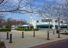
Roosevelt Center in March 2011. The city's commercial center typifies the Art Deco style used during the original construction of Greenbelt.
Flag of Greenbelt, Maryland.svg
Greenbelt md seal.jpg
Prince George's County Maryland Incorporated and Unincorporated areas Greenbelt Highlighted.svg
Greenbelt, Maryland
USA Maryland location map.svg
Red pog.svg
Greenbelt
Location within the state of Maryland
Coordinates: 38°59′41″N76°53′07″W / 38.9946701°N 76.8853989°W / 38.9946701; -76.8853989 [1] [2]
CountryUnited States
State Maryland
County Prince George's
Incorporated June 1, 1937 (1937-06-01) [3]
Government
   Mayor Emmett V. Jordan (D)
Area
[4]
  Total6.29 sq mi (16.29 km2)
  Land6.24 sq mi (16.15 km2)
  Water0.06 sq mi (0.14 km2)  0.99%
Elevation
157 ft (48 m)
Population
 (2020)
  Total24,921
  Density3,996.95/sq mi (1,543.35/km2)
Time zone UTC−05:00 (Eastern)
  Summer (DST) UTC−04:00 (Eastern)
ZIP Codes
20770, 20771, 20768
Area codes
  • 301
  • 240
FIPS code 24-34775
GNIS feature ID 2390596
Website www.greenbeltmd.gov

Greenbelt is a city in Prince George's County, Maryland, United States, and a suburb of Washington, D.C. [1] [2] At the 2020 census, the population was 24,921. [5]

Contents

Greenbelt is the first and the largest of the three experimental and controversial New Deal Greenbelt Towns, the others being Greenhills, Ohio, and Greendale, Wisconsin. Greenbelt was planned and built by the federal government as an all-white town. [6] [7] The cooperative community was conceived in 1935 by Undersecretary of Agriculture Rexford Guy Tugwell, whose perceived collectivist ideology attracted opposition to the Greenbelt Towns project throughout its short duration. [8] [7] The project came into legal existence on April 8, 1935, when Congress passed the Emergency Relief Appropriation Act of 1935. [9] [8] Under the authority granted to him by this legislation, President Franklin D. Roosevelt issued an executive order, on May 1, 1935, establishing the United States Resettlement Administration (RA/RRA). [8]

First called Maryland Special Project No. 1, the project was officially named Greenbelt when the Division of Suburban Resettlement of the Resettlement Administration began construction, on January 13, 1936, about eight miles north of Washington. [7] The complete Greenbelt plans were reviewed at the White House by President Roosevelt and First Lady Eleanor Roosevelt on April 30, 1936. [7] The first tenants, after selection in a stringent application process, moved in to the town on September 30, 1937. [7] The construction consisted of structures built in the Art Deco, Streamline Moderne, and Bauhaus architectural styles. [7]

Greenbelt is credited as a historic milestone in urban development because it was the initial model for the privately constructed suburban Washington, D.C., planned cities of Reston, Virginia, and Columbia, Maryland. [7]

The original federally built core of the city, known locally as Old Greenbelt, was recognized as the Greenbelt Historic District by the Maryland Historical Trust, and is listed on the National Register of Historic Places as a National Historic Landmark District.

Greenbelt's population, which includes residents of privately built dwellings dating from after the end of the federal government's ownership of the city, was recorded as 23,068 at the 2010 U.S. Census and 24,921 at the 2020 census. [5]

Geography

Winter view of Still Creek in Greenbelt Park Still Creek.jpg
Winter view of Still Creek in Greenbelt Park

Greenbelt is located at 38°59′41″N76°53′07″W / 38.99467°N 76.885399°W / 38.99467; -76.885399 . [1] [2] According to United States Census Bureau data, as of January 1, 2018, the city has a total area of 6.23 square miles (16,146,235 square meters ), of which 6.18 square miles (16,003,389 square meters) is land and 0.06 square miles (142,846 square meters) is water. [1] [2] Greenbelt's ZIP Codes are 20770, 20771, and 20768. The ZIP Code 20770 contains all residential and business addresses that correspond to actual physical locations inside the geographic boundaries of the City of Greenbelt. The 20768 ZIP Code is assigned exclusively to post-office box (P.O. Box) addresses, while 20771 is the designated ZIP Code for Goddard Space Flight Center, situated on federal government owned land that is contiguous with a portion of Greenbelt's eastern border. [10] [11]

NASA's Goddard Space Flight Center, located directly adjacent to Greenbelt's eastern boundary, utilizes a Greenbelt postal address (Greenbelt, MD 20768), as well. It is partially within the former Goddard census-designated place. [12] [13]

Greenbelt Park, a unit of the National Park System, is located within the City of Greenbelt's boundaries, at its southernmost portion.

Transportation

I-95/I-495 southbound in Greenbelt 2019-07-05 13 42 09 View south along Interstate 95 and Interstate 495 (Capital Beltway) from the overpass for Cherrywood Lane in Greenbelt, Prince George's County, Maryland.jpg
I-95/I-495 southbound in Greenbelt

Roads and highways

Two major highways pass through and have interchanges in Greenbelt: the Capital Beltway (I-95/I-495) and the National Park Service's owned and maintained portion of the Baltimore–Washington Parkway (unsigned MD 295). The Greenbelt portion of the Baltimore–Washington Parkway (B–W Parkway) is part of the parkway's 19-mile section which was listed on the National Register of Historic Places in 1991. [14]

Additionally, Greenbelt Road is part of state highway MD 193, which connects several suburban communities in both Prince George's and Montgomery counties. Kenilworth Avenue (MD 201) traverses Greenbelt in a north–south direction, running parallel to the B–W Parkway, providing an alternate travel route into Washington, D.C., from Greenbelt. The southernmost Maryland portion of Kenilworth Avenue forms a major interchange with both the B–W Parkway and US 50 near the Maryland–D.C. line, and continues into Washington, as the Kenilworth Avenue Freeway (DC 295).

Public transportation

Debut of a next generation WMATA 7000-series rail car at Greenbelt Metro Station Metro 7000-Series railcar debut 3.jpg
Debut of a next generation WMATA 7000-series rail car at Greenbelt Metro Station

Washington Metro's rapid transit rail system serves Washington, D.C., and neighboring communities in Maryland and Northern Virginia, by operating 98 Metro stations, which includes the Greenbelt station, the northern terminus of Metro's Green Line. Commuter rail service to the station is provided by MARC Train's Camden Line, which connects the District of Columbia's Washington Union Station with Camden Station in Baltimore. The Camden Line provides service by utilizing the original 1835 Baltimore and Ohio Railroad (B&O) track route between Washington and Baltimore, now part of the CSX System.

Also available at Greenbelt station was a weekday express Metrobus service, the Greenbelt–BWI Thurgood Marshall Airport Express Line (commonly shortened to the Greenbelt–BWI Airport Line), designated route B30, to Baltimore/Washington International Thurgood Marshall Airport (BWI), a mode of transportation to and from the airport for airline passengers, in addition to allowing for connections to Baltimore's regional transit services. This service ended in 2020.[ citation needed ]

Metrobus, Prince George's County's THE BUS (routes 11 and 15X), and the University of Maryland's Shuttle-UM (route 143; University ID required) each have bus routes which serve the city of Greenbelt. [15] [16] [17] Through a city–university partnership between 2017 and 2019, Greenbelt residents were permitted to unlimited travel on Shuttle UM, with the purchase of a $10 annual pass. [18] The City operates limited transportation via the Greenbelt Connection, a 12-passenger wheelchair-accessible van. [19]

Bordering areas

Scenic entry to the Nation's Capital: The Baltimore-Washington Parkway Scenic Entry to the Nation's Capital.jpg
Scenic entry to the Nation's Capital: The Baltimore–Washington Parkway

History

The Old Greenbelt Theatre in 2020, with a marquee referencing the George Floyd protests. The theatre opened on September 21, 1938, screening the film Little Miss Broadway with Shirley Temple. Old Greenbelt Theatre June 2020.jpg
The Old Greenbelt Theatre in 2020, with a marquee referencing the George Floyd protests. The theatre opened on September 21, 1938, screening the film Little Miss Broadway with Shirley Temple.

Greenbelt was settled on September 30, 1937, as a public cooperative community in the New Deal era. [7] The concept was at the same time both eminently practical and idealistically utopian: the federal government would foster an "ideal" self-sufficient cooperative community that would also ease the pressing housing shortage near the nation's capital. Construction of the new town would also create jobs and thus help stimulate the national economic recovery following the Great Depression.

Greenbelt, which provided affordable housing for federal government workers, was one of three Greenbelt Towns conceived in 1935, by President Franklin D. Roosevelt's Brain Trust member Rexford Tugwell, who was serving as the president's Undersecretary of Agriculture. The project was officially authorized in May 1935. First, on April 8, 1935, the United States Congress passed the Emergency Relief Appropriation Act of 1935. Then under the authority granted to him from this legislation, President Roosevelt issued an executive order, on May 1, 1935, establishing the United States Resettlement Administration (RA / RRA). [9] [8] Rexford Tugwell agreed to serve as the Administrator of the Resettlement Administration, in addition to his Undersecretary of Agriculture position, without receiving any additional salary. [8]

Working alongside Tugwell was Charles W. Yost. The two other Greenbelt Towns are Greendale, Wisconsin (near Milwaukee) and Greenhills, Ohio (near Cincinnati). A fourth town, Roosevelt, New Jersey (originally called Homestead), was planned but was not fully developed on the same large scale as Greenbelt. [21] [22]

Eleanor Roosevelt, wife of President Franklin D. Roosevelt, helped Tugwell lay out the Maryland town on a site that had formerly consisted largely of tobacco fields. She was also heavily involved in the first cooperative community designed by the federal government in the New Deal Era, Arthurdale, West Virginia, which sought to improve the lives of impoverished laborers by enabling them to create a self-sufficient, and relatively prosperous, cooperative community. Cooperatives in Greenbelt include the Greenbelt News Review , Greenbelt Consumers Coop grocery store, the New Deal Cafe, and the cooperative forming the downtown core of original housing, Greenbelt Homes Incorporated (GHI). [21]

The architectural planning of Greenbelt was innovative, as was the social engineering involved in this federal government project. [23] Applicants for residency were interviewed and screened based on income and occupation, and willingness to become involved in community activities. [24] African-Americans were initially excluded, but were later included by the Greenbelt Committee for Fair Housing founded in 1963, and came to account for 41% of residents, according to the 2000 census. [25] [24] [26] The same census data also indicates that African-Americans are isolated in certain parts within the town, and the percentage of African-Americans within the historic area is between 0% and 5% on most blocks. [27] Much of the federal government planned and developed portion of the city is located within the Greenbelt Historic District.

Greenbelt was the subject of the 1939 documentary film The City .

In 2021, the city created a reparations task force to study the issue of whether or not to award reparations to African-Americans in Greenbelt.

Demographics

Historical population
CensusPop.Note
1940 2,831
1950 7,074149.9%
1960 7,4795.7%
1970 18,199143.3%
1980 17,332−4.8%
1990 21,09621.7%
2000 21,4561.7%
2010 23,0687.5%
2020 24,9218.0%
U.S. Decennial Census [28]
2010 [29] 2020 [30]

2020 census

Greenbelt city, Maryland – Racial and ethnic composition
Note: the US Census treats Hispanic/Latino as an ethnic category. This table excludes Latinos from the racial categories and assigns them to a separate category. Hispanics/Latinos may be of any race.
Race / ethnicity (NH = Non-Hispanic)Pop 2010 [29] Pop 2020 [30] % 2010% 2020
White alone (NH)5,9745,17625.90%20.77%
Black or African American alone (NH)10,85211,89747.04%47.74%
Native American or Alaska Native alone (NH)43470.19%0.19%
Asian alone (NH)2,2382,3239.70%9.32%
Pacific Islander alone (NH)18100.08%0.04%
Some Other Race alone (NH)611920.26%0.77%
Mixed Race or Multi-Racial (NH)5819962.52%4.00%
Hispanic or Latino (any race)3,3014,28014.31%17.17%
Total23,06824,921100.00%100.00%

2010 census

During the census of 2010, there were 23,068 people, 9,747 households, and 5,367 families residing in the city. [31] The population density was 3,673.2 inhabitants per square mile (1,418.2/km2). There were 10,433 housing units at an average density of 1,661.3 per square mile (641.4/km2). The racial makeup of the city was 30.1% White, 47.8% African American, 0.3% Native American, 9.7% Asian, 0.1% Pacific Islander, 8.6% from other races, and 3.3% from two or more races. Hispanic or Latino of any race were 14.3% of the population.

There were 9,747 households, of which 31.0% had children under the age of 18 living with them, 30.7% were married couples living together, 18.3% had a female householder with no husband present, 6.0% had a male householder with no wife present, and 44.9% were non-families. 36.1% of all households were made up of individuals, and 7.3% had someone living alone who was 65 years of age or older. The average household size was 2.37 and the average family size was 3.12.

The median age in the city was 33.7 years. 22.8% of residents were under the age of 18; 10.1% were between the ages of 18 and 24; 34.4% were from 25 to 44; 25.3% were from 45 to 64, and 7.5% were 65 years of age or older. The gender makeup of the city was 46.7% male and 53.3% female.

2000 census

For the census of 2000, there were 21,456 people, 9,368 households, and 4,965 families residing in the city. [26] The population density was 3,586.6 people per square mile (1,385.3/km2). There were 10,180 housing units at an average density of 1,701.7 per square mile (657.3/km2). The racial makeup of the city was 39.7% White, 41.4% African American, 0.2% Native American, 12.1% Asian, 0.1% Pacific Islander, 3.1% from other races, and 3.5% from two or more races. Hispanic or Latino of any race were 6.5% of the population.

There were 11,202 households, out of which 26.9% had children under the age of 18 living with them, 33.1% were married couples living together, 15.0% had a female householder with no husband present, and 47.0% were non-families. 35.0% of all households were made up of individuals, and 5.8% had someone living alone who was 65 years of age or older. The average household size was 2.29 and the average family size was 3.00.

In the city, the population was spread out, with 21.9% under the age of 18, 12.5% from 18 to 24, 39.1% from 25 to 44, 19.8% from 45 to 64, and 6.7% who were 65 years of age or older. The median age was 32 years. For every 100 females, there were 91.8 males. For every 100 females age 18 and over, there were 88.2 males.

The median income for a household in the city was $46,328, and the median income for a family was $55,671. Males had a median income of $39,133 versus $35,885 for females. The per capita income for the city was $25,236. About 6.0% of families and 10.2% of the population were below the poverty line, including 12.7% of those under age 18 and 7.2% of those age 65 or over.

Government

The City of Greenbelt operates under a council-manager government as established by the city charter, the first such arrangement in Maryland. [23] The Council consists of seven members elected by plurality-at-large voting. From their members, the Council selects the Mayor and the Mayor Pro Tem (who assumes the duties of the Mayor when the Mayor is unavailable). The Council has traditionally chosen the member with the highest vote count to be Mayor and the member with the second-highest vote count as Mayor Pro Tem. Elections are held every two years, in odd-numbered years, in part to diminish the influence of political parties. Political party affiliations are not an official part of the city election process and are seldom part of candidate campaigns. Regular council meetings are held on Mondays, twice per month except during July, August, and December, when meetings are held once per month. [32]

The City Council is supported by 14 advisory boards and committees of citizen volunteers. The council appoints a professional city manager responsible for supervising government operations and implementing the policies adopted by the council.

The 2021 election selected the current city council:

The council selects the City Manager:

2009 election reform

Of the ten incorporated cities in Prince George's County, Greenbelt is one of three with at-large elections for council and mayor (the others are District Heights and New Carrollton). The remaining seven use combinations of districts and at-large voting. On February 28, 2008, the Maryland American Civil Liberties Union and Prince George's County NAACP sent a letter to the Greenbelt City Council claiming that Greenbelt's at-large system may violate Section 2 of the Voting Rights Act of 1965. [35] According to the letter, the 2000 Census indicated that African-Americans constituted 38% of Greenbelt's voting-age population, Asians 13%, and Latinos 6%. At the time, however, all members of the city council were white. The letter proposed that the city switch to single-winner district-based voting, cumulative voting, or choice voting, and indicated a lawsuit would follow if no reform were implemented. [36] While the city population is racially diverse, only two African Americans had run for Council in the 30 years preceding the 2009 election, one of whom had withdrawn before the election. [37] [38] In June 2008, the United States Department of Justice opened an investigation into the city's election system. [39]

In 2008, the city government hosted three public community meetings regarding election reform, in concert with the ACLU, NAACP, and FairVote. [40] Over 100 residents attended the forums, including one of the unsuccessful African American candidates, Jeanette Gordy, who said, "My concern is that people don't get off their royal behinds. By going to meetings I got what I wanted and found out I had power as a citizen." [41]

In 2009, the city implemented several election reforms with the goal of increasing diversity: increasing the city council from five to seven members, adding another precinct in Greenbelt East to shorten voter lines, and amending the city charter to allow early voting. [42]

In the election held November 3, 2009, Emmett Jordan, an African American, was chosen by 75% of voters, electing him to the Council as Mayor Pro Tem, the second-highest city official. [43] [44] Voter turnout increased from 1,898 to 2,399 voters (a 26% increase in ballots cast) from 2007 to 2009. [45]

In the election held November 5, 2013, Emmett Jordan was chosen by 77% of voters, and receiving highest vote count was then elected Mayor by the council. [46] [47]

County government

Prince George's County Police Department District 1 Station in Hyattsville; [48] District 2 Station in Brock Hall CDP, with a Bowie postal address; [49] and District 6 Station in Beltsville CDP serve the community. [50]

Federal government

Greenbelt Historic District

The federally planned and constructed inner core of the city was designated as the Greenbelt Historic District by the Maryland Historical Trust, and subsequently placed on the National Park Service's maintained National Register of Historic Places on November 25, 1980. The historic district was elevated to National Historic Landmark District status on February 18, 1997. The district contains Roosevelt Center (originally named simply The Center, and later renamed in honor of President Roosevelt) and many buildings in the Art Deco style. [7] Roosevelt Center contains the Greenbelt Co-op Supermarket and Pharmacy (the Co-op), which opened in 1984, and the original, historic Old Greenbelt Theatre, while also adding the Greenbelt Arts Center (located underneath the Co-op, in what was previously the city's bowling alley), and additional new businesses such as the New Deal Cafe, with its name honoring the origins of its location. [7] [52] [53] Both the Co-op and the New Deal Cafe carry on a tradition from the city's inception, as they operate as non-profit cooperative membership corporations. [53] [54] [52] [55]

Education

Greenbelt Middle School Greenbelt Middle School.jpg
Greenbelt Middle School

Greenbelt is served by Prince George's County Public Schools (PGCPS). [56] [57]

There are three public elementary schools serving sections of Greenbelt: [58]

All of Greenbelt is served by Greenbelt Middle School (Greenbelt), [59] which includes a Talented and Gifted magnet program.

All of Greenbelt is served by Eleanor Roosevelt High School (Greenbelt), [60] a school which includes a Science and Technology magnet program and an AP Capstone program. [61]

There is a public magnet school within the City:

There are no private schools within the City of Greenbelt. There is a Catholic school in nearby Lanham CDP, Academy of Saint Matthias the Apostle. [62] [63]

History of schools

The Lanham Act was used to build North End Elementary School. [64] The original Greenbelt High School building (later used for Greenbelt Junior High, Greenbelt Middle, and currently Dora Kennedy French Immersion School) opened in c.1937. [65] Originally, the Federal Works Agency controlled North End Elementary School, Greenbelt High School, and the Center School. High Point High School, in Beltsville, opened in fall 1954, and began serving students from Greenbelt. The former Greenbelt High School then became Greenbelt Junior High School. The county bought Center School for $260,000, after the federal government renovated it in July 1958. The county also bought Greenbelt Junior High and North End Elementary. [64] Roosevelt High was scheduled to open in fall 1976. [66] The new Greenbelt Middle School opened on August 20, 2012. [65]

Public libraries

Greenbelt is served by the Greenbelt Branch of the Prince George's County Memorial Library System. [67]

Notable people

Economy

Top employers

According to Greenbelt's 2018 Comprehensive Annual Financial Report, [68] the top employers in the city were:

NumberEmployerEmployees
1City of Greenbelt463
2 Bozzuto Group 460
3 Eleanor Roosevelt High School 350
4 Burlington Stores, Inc. 229
5Springhill Lake Hotel Partners, LLC148
6Paradyme Management Inc.134
7 Martin's 130
8 Giant Food of Maryland, LLC 126
9Greenbelt Middle School123
10ATA Aerospace, LLC116

Note that data was taken from only employers who made information available, and the list does not include the US Federal Government (including NASA's Goddard Space Flight Center adjacent to Greenbelt).

In late 2023, the General Services Administration (GSA) announced that FBI was consolidating offices in Greenbelt. It is a huge project, next to the Metro station, to serve 7,500 staff. Besides the FBI complex, substantial development around the Metro station is planned. It is 13 miles (20 kilometers) northeast of the District. Site selection has been a 10 year project. The state of Virginia has challenged the choice, putting the Inspector General to work reviewing the selection, [69] with no change to the GSA decision as of March 2024. [70]

1-Greenbelt Community Center Preamble to the Constitution of the US by WPA Sculptress Leonore Thomas Strauss.JPG
Lenore Thomas Straus panel, Community Center
Greenbelt Museum Exterior 1.jpg
Greenbelt Museum
Greenbelt - Albert S Buddy Attick Lake Park 06.JPG
Albert S. "Buddy" Attick Lake Park
2008 04 02 - Greenbelt - Centerway pedestrian path 2.JPG
Grade-separated pedestrian path
2008 04 02 - Greenbelt - Apartments 6.jpg
Extensive pedestrian pathway system connects residences
2008 04 02 - Greenbelt - Apartments 4.JPG
Art Deco apartments

See also

Related Research Articles

<span class="mw-page-title-main">Prince George's County, Maryland</span> County in Maryland, United States

Prince George's County is located in the U.S. state of Maryland bordering the eastern portion of Washington, D.C. As of the 2020 U.S. census, the population was 967,201, making it the second-most populous county in Maryland, behind neighboring Montgomery County. The 2020 census counted an increase of nearly 104,000 in the previous ten years. Its county seat is Upper Marlboro. It is the largest and the second most affluent African American-majority county in the United States, with five of its communities identified in a 2015 top ten list.

<span class="mw-page-title-main">College Park, Maryland</span> City in Maryland, United States

College Park is a city in Prince George's County, Maryland, United States, located approximately four miles (6.4 km) from the northeast border of Washington, D.C. Its population was 34,740 at the 2020 United States census. It is the home of the University of Maryland, College Park.

<span class="mw-page-title-main">Beltsville, Maryland</span> CDP in Maryland, United States

Beltsville is a census-designated place (CDP) in northern Prince George's County, Maryland, United States. The community was named for Truman Belt, a local landowner. The 2020 census counted 20,133 residents. Beltsville includes the unincorporated community of Vansville.

<span class="mw-page-title-main">Berwyn Heights, Maryland</span> Town in Maryland

Berwyn Heights is a town in Prince George's County, Maryland, United States. Per the 2020 census, the population was 3,345. It is bordered by College Park to the west, Greenbelt to the northeast, and Riverdale Park to the south.

<span class="mw-page-title-main">Chillum, Maryland</span> Census-designated place in Maryland

Chillum is an unincorporated area and census-designated place in Prince George's County, Maryland, United States, bordering Washington, D.C., and Montgomery County.

<span class="mw-page-title-main">Goddard, Maryland</span> Unincorporated community in Maryland

Goddard is an unincorporated community and former census-designated place (CDP) in Prince George's County, Maryland, United States. It was named after the physicist Robert H. Goddard. The population was 5,554 in the 2000 census. The area was no longer a census-designated place as of the 2010 census.

<span class="mw-page-title-main">Laurel, Maryland</span> City in Maryland, United States

Laurel is a city in Maryland, United States, located midway between Washington, D.C. and Baltimore on the banks of the Patuxent River. While the city limits are entirely in northern Prince George's County, outlying developments extend into Anne Arundel, Montgomery and Howard counties. Founded as a mill town in the early 19th century, Laurel expanded local industry and was later able to become an early commuter town for Washington and Baltimore workers following the arrival of the Baltimore and Ohio Railroad in 1835. Largely residential today, the city maintains a historic district centered on its Main Street, highlighting its industrial past.

Seabrook is an unincorporated community and census-designated place (CDP) in Prince George's County, Maryland, United States, located approximately 12 miles (19 km) east of Washington, D.C. Per the 2020 census, the population was 19,627. Prior to 2010, Seabrook was part of the Lanham-Seabrook census-designated place.

Palmer Park is an unincorporated community in Prince George's County, Maryland, United States, within the census-designated place of Landover. It was previously a CDP of its own until 2000.

Laurel High School is a public high school located in Laurel, Maryland, United States; it is the oldest school in the Prince George's County Public Schools system.

<span class="mw-page-title-main">Eleanor Roosevelt High School (Maryland)</span> Public magnet high school in the United States

Eleanor Roosevelt High School (ERHS) is a Maryland public magnet high school specializing in science, technology, engineering, and mathematics. The school was established in 1976 at its current location in Greenbelt, Maryland, United States and is part of the Prince George's County Public Schools system. It was the first high school named for former first lady Eleanor Roosevelt.

<span class="mw-page-title-main">Bladensburg High School</span> Public secondary school in Bladensburg, Maryland, United States

Bladensburg High School is a public high school located in Bladensburg, Maryland, United States. The school, which serves grades 9 through 12, is a part of the Prince George's County Public Schools district.

<span class="mw-page-title-main">Prince George's County Public Schools</span> Public school district in Prince Georges County, Maryland

Prince George's County Public Schools (PGCPS) is a public school district that serves Prince George's County, Maryland. During the 2023-2024 academic year, the district enrolls around 133,000 students and operates over 200 schools. PGCPS is the second-largest school district in Maryland, the third-largest district in the Washington-Baltimore metropolitan area, the 18th-largest in the United States, and the nation's largest school district with a majority-black student population.

<span class="mw-page-title-main">Maryland Route 193</span> Highway in Maryland, United States

Maryland Route 193 is a state highway in the U.S. state of Maryland. Known for most of its length as University Boulevard and Greenbelt Road, the state highway runs 26.07 mi (41.96 km) from MD 185 in Kensington east to MD 202 north of Upper Marlboro. MD 193 serves as a major east-west commuter route in eastern Montgomery County and northern Prince George's County, connecting Wheaton, Silver Spring, Langley Park, College Park, and Greenbelt. The state highway also provides the primary access to the University of Maryland and Goddard Space Flight Center. In central Prince George's County, MD 193 is the main north–south highway connecting Glenn Dale and Greater Upper Marlboro with the affluent suburbs of Woodmore and Kettering.

Friendly High School is a public high school in Friendly census-designated place in unincorporated Prince George's County, a county in the state of Maryland in the United States; it has a Fort Washington postal address.

<span class="mw-page-title-main">High Point High School</span> Public high school in Beltsville, Maryland, United States

High Point High School (HPHS) is a public high school located in Beltsville, an unincorporated section of Prince George's County, Maryland, United States. The school, serving children in grades 9 through 12, is part of the Prince George's County Public Schools district system.

<span class="mw-page-title-main">Charles Herbert Flowers High School</span> Public high school in United States

Charles Herbert Flowers High School is a comprehensive science and technology magnet school located in unincorporated Prince George's County, Maryland, United States, adjacent to the Springdale census-designated place and with a Springdale postal address. It is part of the Prince George's County School System. Its principal is Dr. Gorman Brown.

<span class="mw-page-title-main">Fairmont Heights High School</span> Public comprehensive secondary school in Landover, Maryland , United States

Fairmont Heights High School (est.1950) is an American public comprehensive secondary school located in Landover, Maryland, just outside Washington D.C. It is part of the Prince George's County Public Schools system. Two middle schools feed into Fairmont Heights. It is part of the School Board District 3.

<span class="mw-page-title-main">DuVal High School</span> Public high school in the United States

DuVal High School (DHS) is a comprehensive science and technology public magnet high school in the Seabrook census-designated place in unincorporated Prince George's County, Maryland, United States, with a Lanham postal address. Prior to 2010 the U.S. Census Bureau defined the area containing DuVal High as being within the Goddard CDP.

Summerfield is a census-designated place near Landover in Prince George's County, Maryland. As of the 2020 census, the population was 14,758. It is a suburb of Washington, D.C.

References

  1. 1 2 3 4 "TIGERweb 5.0 - Greenbelt city, internal point latitude and longitude". United States Census Bureau, Geography Division / Esri . Archived from the original on September 14, 2018. Retrieved October 2, 2018.
  2. 1 2 3 4 "State of Maryland Incorporated Places - Current/ACS18 - Data as of January 1, 2018". tigerweb.geo.census.gov. Retrieved October 2, 2018.
  3. Larsen, Christian L.; Andrews, Richard D. (1951). "I: Origin and Growth". The Government of Greenbelt. Studies in Public Administration. College Park: Bureau of Public Administration, College of Business and Public Administration, University of Maryland. pp. 1–8. hdl:2027/uc1.b3526707. OCLC   551390464.
  4. "2020 U.S. Gazetteer Files". United States Census Bureau. Retrieved April 26, 2022.
  5. 1 2 "Greenbelt city, Maryland". United States Census Bureau . Retrieved April 15, 2022.
  6. Loewen, James W. (2018). Sundown towns : a hidden dimension of American racism (2018 ed.). New York. pp. 112–113. ISBN   978-1-62097-434-6. OCLC   1029803624.{{cite book}}: CS1 maint: location missing publisher (link)
  7. 1 2 3 4 5 6 7 8 9 10 Williamson, Mary Lou (1987). Phillips, Nancy O. (ed.). Greenbelt: History of a New Town, 1937-1987. Norfolk, VA: Donning Co. pp. 1–43. hdl:2027/mdp.39015061000652. ISBN   978-0-8986-5612-1. OCLC   607530163.
  8. 1 2 3 4 5 "Franklin D. Roosevelt: Executive Order 7027 Establishing the Resettlement Administration". The American Presidency Project. Archived from the original on September 13, 2018. Retrieved September 13, 2018.
  9. 1 2 "Today in History - April 8". The Library of Congress. Archived from the original on September 3, 2018. Retrieved September 13, 2018.
  10. "All Zip Codes in Greenbelt MD". Zip-Codes.com. Datasheer, L.L.C. Archived from the original on September 13, 2018. Retrieved September 12, 2018.
  11. "Zip Code 20770, Greenbelt, Maryland Boundary Map Version 4.0". ZipMap.net. USNaviguide LLC. Archived from the original on September 13, 2018. Retrieved September 12, 2018.
  12. "CENSUS 2000 BLOCK MAP: GODDARD CDP Archived 2018-09-01 at the Wayback Machine ." U.S. Census Bureau. Retrieved on September 1, 2018. 1990 Census map of Prince George's County (index map) has Goddard CDP on Page 9 Archived 2018-09-01 at the Wayback Machine .
  13. "Driving Directions to the Goddard Visitor Center Archived 2017-05-05 at the Wayback Machine ." Goddard Space Flight Center. Retrieved on September 1, 2018. "8800 Greenbelt Road Greenbelt, MD 20771" - Driving Directions Map Archived 2018-09-01 at the Wayback Machine , Campus Map Archived 2018-09-01 at the Wayback Machine
  14. "Baltimore–Washington Parkway — Maryland's National Register Properties". Maryland Historical Trust. Retrieved September 11, 2018.
  15. "Route 11 — Maps & Schedules" (PDF). Prince George's County Department of Public Works & Transportation. 2011. Retrieved November 29, 2018.
  16. "Route 15X — Maps & Schedules" (PDF). Prince George's County Department of Public Works & Transportation. 2017. Archived from the original on May 22, 2017. Retrieved November 29, 2018.
  17. "143 GREENBELT" (PDF). College Park: University of Maryland Department of Transportation Services. 2018. Archived (PDF) from the original on November 29, 2018. Retrieved November 29, 2018.
  18. "UMD Shuttle Pass". City of Greenbelt. Archived from the original on November 29, 2018. Retrieved November 29, 2018.
  19. "Greenbelt Connection Bus Service | Greenbelt, MD".
  20. "Old Greenbelt Theatre". www.facebook.com. Archived from the original on February 26, 2022. Retrieved June 10, 2020.
  21. 1 2 Halpern, Sue (May–June 2002), "New Deal City", Mother Jones , archived from the original on February 16, 2009, retrieved July 7, 2007
  22. "Greendale Originals - The shops, history and events in the Village of Greendale, Wisconsin". Archived from the original on February 7, 2012.
  23. 1 2 "HOUSING: Greenbelt". Time. September 13, 1937. Archived from the original on December 22, 2011. Retrieved July 23, 2010.
  24. 1 2 "Images and Voices of Greenbelt: Oral Histories". Virtual Greenbelt. University of Maryland. 2000. Archived from the original on June 7, 2010. Retrieved July 23, 2010.
  25. Vick, Karl (April 20, 1997). "In FDR Years, 'Sleepy Southern Town' Woke Up". The Washington Post . Archived from the original on October 24, 2012. Retrieved November 3, 2009.
  26. 1 2 "U.S. Census website". United States Census Bureau . Retrieved January 31, 2008.
  27. "20770 Zip Code (Greenbelt, Maryland) Profile — homes, apartments, schools, population, income, averages, housing, demographics, location, statistics, sex offenders, residents and real estate info". City-Data.com. Archived from the original on March 11, 2016. Retrieved March 11, 2016.
  28. "Decennial Census by Decade". US Census Bureau.
  29. 1 2 "P2 Hispanic or Latino, and Not Hispanic or Latino by Race – 2010: DEC Redistricting Data (PL 94-171) – Greenbelt city, Maryland". United States Census Bureau .
  30. 1 2 "P2 Hispanic or Latino, and Not Hispanic or Latino by Race – 2020: DEC Redistricting Data (PL 94-171) – Greenbelt city, Maryland". United States Census Bureau .
  31. "U.S. Census website". United States Census Bureau . Retrieved January 25, 2013.
  32. "Greenbelt City Government". Greenbelt CityLink. City of Greenbelt, Maryland. Archived from the original on September 1, 2008. Retrieved August 24, 2008.
  33. "Get Your Md. Municipal Election Results Here!" (PDF). Greenbelt News Review . November 9, 2023. Retrieved April 14, 2024.
  34. Rosado, Lois (November 9, 2024). "Perspectives of Josué Salmerón, Greenbelt's New City Manager" (PDF). Greenbelt News Review . Retrieved April 14, 2024.
  35. "ACLU Contacts City re: Reform for Fairness of Election System" (PDF). Greenbelt News Review . March 27, 2008. pp. 1, 6. Archived (PDF) from the original on September 11, 2008. Retrieved August 24, 2008.
  36. Jeon, Deborah A. (February 28, 2008). "Legal Director, American Civil Liberties Union of Maryland, Letter to the Greenbelt City Council" (PDF). Archived from the original (PDF) on January 13, 2016. Retrieved August 24, 2008.
  37. McLaughlin, Michael (June 3, 2008). "City Manager of Greenbelt Response to Gazette editorial" (PDF). Archived from the original (PDF) on July 18, 2011. Retrieved September 27, 2010.
  38. Attebury, Jordan; Lyles, Jeffrey K. (December 3, 2009). "A change in complexion for Greenbelt". Washington Post . Archived from the original on June 4, 2011. Retrieved January 12, 2010.
  39. McGill, Natalie (June 5, 2008). "Probe of election system begins". Maryland Gazette. Archived from the original on May 22, 2011. Retrieved July 17, 2008.
  40. Woods, Bay (October 9, 2008). "NAACP and ACLU Hold Their Third Meeting in Greenbelt West" (PDF). Greenbelt News Review . pp. 1, 6. Archived (PDF) from the original on July 11, 2011. Retrieved November 7, 2009.
  41. White, Thomas X. (August 28, 2008). "County Groups Seek to Change Manner of Voting in Greenbelt" (PDF). Greenbelt News Review . pp. 1, 12. Archived (PDF) from the original on October 29, 2008. Retrieved September 11, 2008.
  42. Attebury, Jordan (September 24, 2009). "Nine candidates vie for city office". Maryland Gazette. Archived from the original on January 13, 2016. Retrieved November 4, 2009.
  43. Giese, James (November 5, 2009). "Jordan, Davis, City Are the Big Winners in City Council Election" (PDF). Greenbelt News Review . pp. 1, 8. Archived (PDF) from the original on July 11, 2011. Retrieved November 7, 2009.
  44. Attebury, Jordan (November 3, 2009). "Greenbelt elects first black city councilman". Maryland Gazette. Archived from the original on January 13, 2016. Retrieved November 4, 2009.
  45. "City of Greenbelt 2009 Election Results". November 4, 2009. Archived from the original on January 12, 2010. Retrieved November 4, 2009.
  46. Giese, James (November 7, 2013). "Emmett Jordan Gets Top Vote All Incumbents Are Re-elected" (PDF). Greenbelt News Review . pp. 1, 7. Archived (PDF) from the original on November 26, 2013. Retrieved November 16, 2013.
  47. Oberg, Diane (November 14, 2013). "Full House Sees Emmett Jordan Elected and Inducted as Mayor" (PDF). Greenbelt News Review . pp. 1, 6. Archived (PDF) from the original on November 25, 2013. Retrieved November 16, 2013.
  48. "District 1 Station - Hyattsville Archived 2018-09-09 at the Wayback Machine . Prince George's County Police Department. Retrieved on September 9, 2018. Beat map Archived 2018-09-09 at the Wayback Machine .
  49. "District 2 Station - Bowie Archived 2018-09-09 at the Wayback Machine ." Prince George's County Police Department. Retrieved on September 9, 2018. "District 2 Station - Bowie 601 SW Crain Highway Bowie, MD 20715 ". Beat map Archived 2018-09-09 at the Wayback Machine . 2010 U.S. Census Bureau index map of Brock Hall CDP Archived 2018-08-28 at the Wayback Machine as well as the detail on Page 1 .
  50. "District 6 Station - Beltsville Archived 2018-09-09 at the Wayback Machine ." Prince George's County Police Department. Retrieved on September 9, 2018. "4321 Sellman Road Beltsville, MD 20704 ". Beat map Archived 2018-09-09 at the Wayback Machine . See 2010 U.S. Census index map of Beltsville CDP Archived 2018-08-26 at the Wayback Machine : area with police station is page 3 Archived 2018-08-26 at the Wayback Machine .
  51. "GREENBELT Archived 2018-09-28 at the Wayback Machine ." U.S. Postal Service. Retrieved on September 11, 2018. "7600 ORA GLEN DR GREENBELT, MD 20770-9998"
  52. 1 2 "About Us — Greenbelt Co-op Supermarket and Pharmacy". Greenbelt Co-op Supermarket and Pharmacy. Archived from the original on September 13, 2018. Retrieved September 12, 2018.
  53. 1 2 "About the Cafe — New Deal Cafe". New Deal Cafe. Archived from the original on November 30, 2018. Retrieved September 12, 2018.
  54. "Members — New Deal Cafe". New Deal Cafe. Archived from the original on February 17, 2019. Retrieved September 12, 2018.
  55. "Frequently Asked Questions — Greenbelt Co-op Supermarket and Pharmacy". Greenbelt Co-op Supermarket and Pharmacy. Archived from the original on September 13, 2018. Retrieved September 12, 2018.
  56. "Schools". City of Greenbelt. Archived from the original on November 22, 2018. Retrieved November 22, 2018.
  57. "2010 CENSUS - CENSUS BLOCK MAP (INDEX): Greenbelt city, MD Archived 2018-09-01 at the Wayback Machine ." U.S. Census Bureau. Retrieved on September 1, 2018.
  58. "NEIGHBORHOOD ELEMENTARY SCHOOLS AND BOUNDARIES SCHOOL YEAR 2018-2019 Archived 2018-11-13 at the Wayback Machine ." Prince George's County Public Schools. Retrieved on September 1, 2018.
  59. "NEIGHBORHOOD MIDDLE SCHOOLS AND BOUNDARIES SCHOOL YEAR 2018-2019 Archived 2018-11-13 at the Wayback Machine ." Prince George's County Public Schools. Retrieved on September 1, 2018.
  60. "NEIGHBORHOOD HIGH SCHOOLS AND BOUNDARIES SCHOOL YEAR 2018-2019 Archived 2018-11-13 at the Wayback Machine ." Prince George's County Public Schools. Retrieved on September 1, 2018.
  61. "Eleanor Roosevelt High School". Prince George's County Public Schools. Archived from the original on February 25, 2018. Retrieved February 26, 2018.
  62. "Elementary Schools Archived 2018-09-01 at the Wayback Machine ." City of Greenbelt. Retrieved on September 1, 2018. "The Academy of Saint Matthias the Apostle 9473 Annapolis Road Lanham, MD 20706 "
  63. "2010 CENSUS - CENSUS BLOCK MAP: Lanham CDP, MD Archived 2018-09-01 at the Wayback Machine ." U.S. Census Bureau. Retrieved on September 1, 2018.
  64. 1 2 Knepper, Cathy D. (March 9, 2001). Greenbelt, Maryland: A Living Legacy of the New Deal. Creating the North American Landscape. Baltimore: Johns Hopkins University Press. p. 109. ISBN   978-0-8018-6490-2. OCLC   46670572. OL   6776113M . Retrieved November 21, 2018.
  65. 1 2 Afenson–Comeau, Jamie (October 24, 2012). "Prince George's officials consider moving French immersion program to shuttered Greenbelt school". The Gazette . Archived from the original on September 10, 2018. Retrieved September 11, 2018.
  66. Knepper, Cathy D. (March 9, 2001). Greenbelt, Maryland: A Living Legacy of the New Deal. Creating the North American Landscape. Baltimore: Johns Hopkins University Press. p. 149. ISBN   978-0-8018-6490-2. OCLC   46670572. OL   6776113M . Retrieved November 21, 2018.
  67. "Greenbelt Branch". Prince George's County Memorial Library System. Archived from the original on August 29, 2018. Retrieved November 22, 2018.
  68. "Comprehensive Annual Financial Report for Fiscal Year Ended June 30, 2018". Greenbelt, Maryland. Archived from the original on April 19, 2019. Retrieved April 20, 2019.
  69. "Inspector general investigating the decision to relocate FBI headquarters to Maryland". NPR. November 30, 2023. Retrieved March 24, 2024.
  70. Goffman, Ethan (February 5, 2024). "What the FBI move to Greenbelt means for Prince George's County and the region". Greater Greater Washington. Retrieved March 24, 2024.

Further reading