Marlow Heights, Maryland

Last updated

Marlow Heights, Maryland
Prince George's County Maryland Incorporated and Unincorporated areas Marlow Heights Highlighted.svg
Location of Marlow Heights, Maryland
Coordinates: 38°49′31″N76°56′52″W / 38.82528°N 76.94778°W / 38.82528; -76.94778
Country Flag of the United States.svg United States
State Flag of Maryland.svg  Maryland
County Flag of Prince George's County, Maryland.svg Prince George's
Area
[1]
  Total2.03 sq mi (5.27 km2)
  Land2.03 sq mi (5.26 km2)
  Water0.00 sq mi (0.01 km2)
Elevation
262 ft (80 m)
Population
 (2020)
  Total6,169
  Density3,035.93/sq mi (1,171.98/km2)
Time zone UTC−5 (Eastern (EST))
  Summer (DST) UTC−4 (EDT)
ZIP codes
20746, 20748
Area code(s) 301, 240
FIPS code 24-50750
GNIS feature ID0597719

Marlow Heights is an unincorporated area and census-designated place (CDP) in Prince George's County, Maryland, United States. [2] The population was 6,169 at the 2020 census. [3] The Marlow Heights Shopping Center first opened in 1957 (but extended in 1960 with Hecht's), adjacent to the large community of Hillcrest Heights. [4] It was joined ten years later, in 1967, by the two-level Iverson Mall, [5] [6] the Washington metropolitan area's first enclosed mall. [7]

Contents

For mailing address purposes, the area is part of Temple Hills or Suitland. Marlow Heights is located near the U.S. Census Bureau, Andrews Air Force Base, the Metrorail Green Line and Capitol Hill.

Geography

Marlow Heights is located at 38°49′31″N76°56′52″W / 38.82528°N 76.94778°W / 38.82528; -76.94778 (38.825263, 76.947864). [8]

According to the United States Census Bureau, the CDP has a total area of 2.1 square miles (5.4 km2), all land.

Demographics

Historical population
CensusPop.Note
2000 6,059
2010 5,618−7.3%
2020 6,1699.8%
U.S. Decennial Census [9]
2010 [10] 2020 [11]

2020 census

Marlow Heights CDP, Maryland – Racial and ethnic composition
Note: the US Census treats Hispanic/Latino as an ethnic category. This table excludes Latinos from the racial categories and assigns them to a separate category. Hispanics/Latinos may be of any race.
Race / Ethnicity (NH = Non-Hispanic)Pop 2010 [10] Pop 2020 [11] % 2010% 2020
White alone (NH)2722114.84%3.42%
Black or African American alone (NH)4,8294,62285.96%74.92%
Native American or Alaska Native alone (NH)21200.37%0.32%
Asian alone (NH)1041091.85%1.77%
Pacific Islander alone (NH)120.02%0.03%
Some Other Race alone (NH)17190.30%0.31%
Mixed Race or Multi-Racial (NH)961551.71%2.51%
Hispanic or Latino (any race)2781,0314.95%16.71%
Total5,6186,169100.00%100.00%

2000 Census

As of the census [12] of 2000, there were 6,059 people, 2,316 households, and 1,588 families residing in the CDP. The population density was 2,938.6 inhabitants per square mile (1,134.6/km2). There were 2,427 housing units at an average density of 1,177.1 per square mile (454.5/km2). The racial makeup of the CDP was 8.12% White, 88.53% African American, 0.23% Native American, 1.02% Asian, 0.36% from other races, and 1.73% from two or more races. Hispanic or Latino of any race were 1.52% of the population.

There were 2,316 households, out of which 35.1% had children under the age of 18 living with them, 35.9% were married couples living together, 26.2% had a female householder with no husband present, and 31.4% were non-families. 24.4% of all households were made up of individuals, and 3.9% had someone living alone who was 65 years of age or older. The average household size was 2.61 and the average family size was 3.09.

In the CDP, the population was spread out, with 27.7% under the age of 18, 9.6% from 18 to 24, 31.9% from 25 to 44, 22.8% from 45 to 64, and 8.0% who were 65 years of age or older. The median age was 34 years. For every 100 females, there were 84.8 males. For every 100 females age 18 and over, there were 77.3 males.

The median income for a household in the CDP was $46,995, and the median income for a family was $52,875. Males had a median income of $33,935 versus $32,500 for females. The per capita income for the CDP was $21,629. About 4.6% of families and 7.8% of the population were below the poverty line, including 8.4% of those under age 18 and 4.5% of those age 65 or over.

Government

Prince George's County Police Department District 4 Station in Glassmanor CDP, with an Oxon Hill postal address, serves the community. [13]

The United States Postal Service operates the Temple Hills Post Office in the Marlow Heights CDP, with a Temple Hills postal address. [14] [15]

Education

The CDP is served by the Prince George's County Public Schools district. [14]

Sections are served by Barnaby Manor and Hillcrest Heights elementary schools. [16] Sections are served by Benjamin Stoddert and Thurgood Marshall middle schools. [17] Sections are served by Crossland High School and Potomac High School. [18]

Imagine Schools operates Imagine Lincoln Public Charter School in Marlow Heights; it has a Temple Hills postal address. [19]

Related Research Articles

<span class="mw-page-title-main">Brandywine, Maryland</span> Census-designated place in Maryland

Brandywine is the name of an unincorporated area in Prince George's County, Maryland, United States, that refers both to a census-designated place (CDP) and a zip code area which is much larger (20613), whose areas overlap. The population of Brandywine at the 2020 U.S. Census was 10,550 for the CDP, and the population of ZIP code 20613 was 11,860 in 2010.

<span class="mw-page-title-main">Camp Springs, Maryland</span> Census-designated place in Maryland

Camp Springs is an unincorporated area and census-designated place (CDP) in Prince George's County, Maryland, United States. The population was 22,734 at the 2020 census. Camp Springs is not an official post office designation; the area is divided among the surrounding mailing addresses of Temple Hills, Fort Washington, Clinton, and Suitland.

<span class="mw-page-title-main">Coral Hills, Maryland</span> Census-designated place in Maryland

Coral Hills is an unincorporated area and census-designated place (CDP) in Prince George's County, Maryland, United States. As of the 2020 census, the population was 9,997.

<span class="mw-page-title-main">Forest Heights, Maryland</span> Town in Maryland

Forest Heights is a town in Prince George's County, Maryland, United States, and is part of the larger postal designation of Oxon Hill. The town straddles both sides of dual-lane Maryland Route 210 and includes two elementary schools. Per the 2020 census, the population was 2,658.

<span class="mw-page-title-main">Fort Washington, Maryland</span> Census-designated place in Maryland

Fort Washington is an unincorporated area and census-designated place in Prince George's County, Maryland, United States. It borders the Potomac River, situated 20 miles south of downtown Washington, D.C. As of the 2020 census, it had a population of 24,261. The Fort Washington community is located west of Maryland Route 210, with some additional area to the east of the highway.

<span class="mw-page-title-main">Hillcrest Heights, Maryland</span> CDP in Maryland

Hillcrest Heights is an unincorporated area and census-designated place (CDP) in Prince George's County, Maryland, United States. The population was 15,793 at the 2020 census. For mailing address purposes, it is part of the smaller community of Temple Hills and is also near Suitland.

<span class="mw-page-title-main">Kettering, Maryland</span> Census-designated place in Maryland, United States

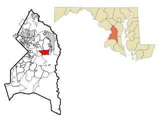
Kettering is an unincorporated area and census-designated place in Prince George's County, Maryland, United States. At the 2020 United States Census, the population was 14,424,. Kettering is adjacent to Prince George's Community College, the upscale gated community of Woodmore, Six Flags America, Evangel Temple megachurch, and the community of Largo at the end of the Washington Metro Blue Line. Watkins Regional Park in Kettering offers a large playground, a colorful carousel, miniature golf, a miniature train ride, and various animals.

<span class="mw-page-title-main">Morningside, Maryland</span> Town in Maryland

Morningside is an incorporated town in Prince George's County, Maryland, United States. Per the 2020 census, the population was 1,240. The town developed with the establishment of nearby Andrews Air Force Base and the federal Census Bureau. The government of the town is led by a mayor and town council. Morningside Elementary School and Benjamin Foulois Junior High School/Elementary/Creative and Performing Arts Academy (current) as well as Michael J Polley Neighborhood Park are located within the town limits. Morningside has one of the largest VFW posts (chapters) in the entire country. Morningside is also the city of license of one of Washington's most prominent radio stations, from the 1960s to the present, WJFK and WPGC-FM. Additionally, Morningside is home to one of the busiest volunteer fire departments in Prince George's County, Morningside VFD Station 827. In 2015, station 827 ran over 8,000 calls for service with 150 working fires in Morningside and the adjacent communities, and has garnered national recognition for their service to the community.

<span class="mw-page-title-main">Oxon Hill-Glassmanor, Maryland</span> Former CDP in Maryland

Oxon Hill-Glassmanor was a census-designated place (CDP) in Prince George's County, Maryland, for the 1990 and 2000 censuses. The combination is arbitrary, and in the mind of most local people there are two separate communities: Oxon Hill and Glassmanor. As of the 2010 census, Oxon Hill, National Harbor and Glassmanor were delineated as separate CDPs.

<span class="mw-page-title-main">Springdale, Maryland</span> Census-designated place in Maryland

Springdale is an unincorporated area and census-designated place (CDP) in Prince George's County, Maryland, United States. Per the 2020 census, the population was 5,301.

<span class="mw-page-title-main">Temple Hills, Maryland</span> Census-designated place in Maryland, United States

Temple Hills is an unincorporated area and census-designated place (CDP) in Prince George's County, Maryland, United States. Temple Hills borders the communities of Hillcrest Heights, Marlow Heights, Camp Springs and Oxon Hill. Per the 2020 census, the population was 8,350.

<span class="mw-page-title-main">Walker Mill, Maryland</span> Census-designated place in Maryland

Walker Mill is an unincorporated area and census-designated place (CDP) in Prince George's County, Maryland, United States. Per the 2020 census, the population was 12,187.

<span class="mw-page-title-main">Calverton, Maryland</span> Census-designated place in Maryland, United States

Calverton is an unincorporated area and census-designated place located on the boundary between Montgomery and Prince George's counties, Maryland, in the United States. At the 2020 census, it had a population of 17,316.

Landover is an unincorporated community and census-designated place in Prince George's County, Maryland, United States. As of the 2020 census, it had a population of 25,998.

Peppermill Village is an unincorporated community near Maryland Route 214 in Prince George's County, Maryland, United States. Per the 2020 census, the population was 5,264. FedExField, Metrorail's Blue Line, and Hampton Mall shopping center are all located nearby. Because it is not formally incorporated, it has no official boundaries, but the United States Census Bureau has defined a census-designated place (CDP) consisting of Peppermill Village and the adjacent community of Carmody Hills, for statistical purposes.

<span class="mw-page-title-main">Oxon Hill, Maryland</span> Census-designated place in Maryland, United States

Oxon Hill is an unincorporated area and census-designated place (CDP) in southern Prince George's County, Maryland, United States. Oxon Hill is a suburb of Washington, located southeast of the downtown district and east of Alexandria, Virginia. Since 2008, it contains the 300-acre (120 ha) National Harbor development on the shore of the Potomac River.

Glassmanor is an unincorporated community and census-designated place in Prince George's County, Maryland, United States. As of the 2020 census, it had a population of 18,430. In the 1990 and 2000 censuses, the United States Census Bureau had placed Glassmanor and the adjacent community of Oxon Hill in the "Oxon Hill-Glassmanor" census-designated place for statistical purposes. Glassmanor was last delineated separately in 1980, when the CDP recorded a population of 7,751.

<span class="mw-page-title-main">Suitland, Maryland</span> Census-designated place in Maryland, United States

Suitland is a suburb of Prince George's County, Maryland, approximately one mile (1.6 km) southeast of Washington, D.C. Suitland is a census designated place (CDP), as of the 2020 census, its population was 25,839. Prior to 2010, it was part of the Suitland-Silver Hill census-designated place.

<span class="mw-page-title-main">Crossland High School</span> Public school in the United States

Crossland High School is a public secondary school located in Camp Springs census-designated place, unincorporated Prince George's County, Maryland, with Temple Hills postal address. The school serves about 2,000 students in grades 9 to 12 in the Prince George's County Public Schools system.

Potomac High School is a public high school located in the Glassmanor census-designated place in unincorporated Prince George's County, Maryland, United States, with an Oxon Hill postal address. It is a part of Prince George's County Public Schools.

References

  1. "2020 U.S. Gazetteer Files". United States Census Bureau. Retrieved April 26, 2022.
  2. U.S. Geological Survey Geographic Names Information System: Marlow Heights, Maryland
  3. "Marlow Heights CDP, Maryland". United States Census Bureau . Retrieved April 15, 2022.
  4. "The Recent Past Preservation Network".
  5. "Mall Hall of Fame".
  6. "one of the six original stores that opened Iverson Mall in 1967".
  7. "History of Iverson Mall".
  8. "US Gazetteer files: 2010, 2000, and 1990". United States Census Bureau. February 12, 2011. Retrieved April 23, 2011.
  9. "Decennial Census of Population and Housing by Decades". US Census Bureau.
  10. 1 2 "P2 Hispanic or Latino, and Not Hispanic or Latino by Race – 2010: DEC Redistricting Data (PL 94-171) – Marlow Heights CDP, Maryland". United States Census Bureau .
  11. 1 2 "P2 Hispanic or Latino, and Not Hispanic or Latino by Race – 2020: DEC Redistricting Data (PL 94-171) – Marlow Heights CDP, Maryland". United States Census Bureau .
  12. "U.S. Census website". United States Census Bureau . Retrieved January 31, 2008.
  13. "District 4 Station - Oxon Hill." Prince George's County Police Department. Retrieved on September 9, 2018. " 5135 Indian Head Highway Oxon Hill, MD 20745". Beat map. See 2010 U.S. Census Map of Glassmanor CDP.
  14. 1 2 "2010 CENSUS - CENSUS BLOCK MAP: Marlow Heights CDP, MD." U.S. Census Bureau. Retrieved on August 29, 2018.
  15. "TEMPLE HILLS." United States Postal Service. Retrieved on September 11, 2018. "4806 SAINT BARNABAS RD TEMPLE HILLS, MD 20748-9997"
  16. "NEIGHBORHOOD ELEMENTARY SCHOOLS AND BOUNDARIES SCHOOL YEAR 2018-2019." Prince George's County Public Schools. Retrieved on August 29, 2018.
  17. "NEIGHBORHOOD MIDDLE SCHOOLS AND BOUNDARIES SCHOOL YEAR 2018-2019." Prince George's County Public Schools. Retrieved on August 29, 2018.
  18. "NEIGHBORHOOD HIGH SCHOOLS AND BOUNDARIES SCHOOL YEAR 2018-2019." Prince George's County Public Schools. Retrieved on August 29, 2018.
  19. "Maryland." Imagine Schools. Retrieved on September 2, 2018. "Imagine Lincoln Public Charter School 4207 Norcross Street Temple Hills, MD 20748"