Lake Arbor, Maryland

Last updated

Lake Arbor, Maryland
Prince George's County Maryland Incorporated and Unincorporated areas Lake Arbor Highlighted.svg
Coordinates: 38°54′30″N76°49′46″W / 38.90833°N 76.82944°W / 38.90833; -76.82944
Country Flag of the United States.svg United States
State Flag of Maryland.svg  Maryland
County Flag of Prince George's County, Maryland (1963-present).svg Prince George's
Area
[1]
  Total4.06 sq mi (10.52 km2)
  Land4.00 sq mi (10.35 km2)
  Water0.07 sq mi (0.17 km2)
Elevation
167 ft (51 m)
Population
 (2020)
  Total14,541
  Density3,638.89/sq mi (1,405.00/km2)
Time zone UTC−5 (Eastern (EST))
  Summer (DST) UTC−4 (EDT)
ZIP Code
20721 & 20774
FIPS code 24-44817
GNIS feature ID1852596

Lake Arbor is an unincorporated area and census-designated place (CDP) in Prince George's County, Maryland, United States. [2] The population was 14,541 at the 2020 census. [3] The ZIP Codes encompassing the CDP area are 20721 and 20774. [4]

Contents

In the 1990s, the U.S. Census Bureau defined the area now delineated as Lake Arbor CDP as being in Mitchellville CDP. [5] The Lake Arbor CDP was delineated as of the 2000 U.S. Census. [6]

History

Lake Arbor was originally known as Newbridge, a development of Levitt & Sons, developers of the early planned communities of Levittown in Pennsylvania and Long Island, New York, respectively. When the project went bankrupt in the mid-1970s after selling only 41 houses, Manufacturer's Hanover Trust acquired the debt and held it as REO (real estate owned) for approximately 10 years until a limited partnership composed of David A. Gitlitz, Alvin Dworman, Phillip Abrahms, Phillip D. Winn, and Gary S. Lachman acquired it. Under the direction of Gitlitz, and with technical engineering assistance from Abrahms, Lachman changed the name of the property to Lake Arbor.

The story of Lake Arbor is emblematic of the socio-economic and demographic evolution of Prince George's County that occurred in the mid-1980s. [7] Against the strong resistance of many large national builders who perceived Prince George’s County as a price-sensitive retreat for urban African Americans who neither wanted nor could afford upscale amenities for their homes, community developers like Porten Sullivan, Pulte, Winchester, George T. Farrell of Morgan Investments and Jon Laria [8] from Laria Builders built features like two-car garages, brick, fronts and elaborate landscaping and built 2000 luxury homes in this community in the 1980s, [9] initiating a new path for the rest of Lake Arbor Community. Reynolds Real Estate acted as selling realtor and Industrial Bank of Washington provided construction and purchase financing. To the pleasant surprise of the builders, buyers rushed to embrace (and pay for) these features. Firmly demonstrating both the sophisticated tastes and buying power of the predominantly African American market, as well as codifying architectural standards requested (but not mandated) by county executives such as Winnie Kelly and Governor Parris Glendening, Lake Arbor established Prince George’s County as the most desirable destination for young, affluent African American families moving from Washington, DC for a suburban lifestyle. [10]

Geography

According to the United States Census Bureau, the CDP has a total area of 3.2 square miles (8.3 km2), of which 3.1 square miles (8.0 km2) is land and 0.1 square miles (0.26 km2), or 1.58%, is water.

Demographics

Historical population
CensusPop.Note
2000 8,533
2010 9,77614.6%
2020 14,45147.8%
U.S. Decennial Census [11]
2010 [12] 2020 [13]

2020 census

Lake Arbor CDP, Maryland – Racial and ethnic composition
Note: the US Census treats Hispanic/Latino as an ethnic category. This table excludes Latinos from the racial categories and assigns them to a separate category. Hispanics/Latinos may be of any race.
Race / Ethnicity (NH = Non-Hispanic)Pop 2010 [12] Pop 2020 [13] % 2010% 2020
White alone (NH)1987622.03%5.24%
Black or African American alone (NH)8,94312,40791.48%85.32%
Native American or Alaska Native alone (NH)24230.25%0.16%
Asian alone (NH)1953111.99%2.14%
Pacific Islander alone (NH)220.02%0.01%
Some Other Race alone (NH)13770.13%0.53%
Mixed Race or Multi-Racial (NH)1614551.65%3.13%
Hispanic or Latino (any race)2405042.45%3.47%
Total9,77614,541100.00%100.00%

2000 Census

As of the census [14] of 2000, there were 8,533 people, 3,493 households, and 2,165 families residing in the CDP. The population density was 2,751.6 inhabitants per square mile (1,062.4/km2). There were 3,662 housing units at an average density of 1,180.9 per square mile (455.9/km2). The racial makeup of the CDP was 7.20% White, 88.74% African American, 0.28% Native American, 1.77% Asian, 0.02% Pacific Islander, 0.42% from other races, and 1.57% from two or more races. Hispanic or Latino of any race were 1.64% of the population.

There were 3,493 households, out of which 34.2% had children under the age of 18 living with them, 40.1% were married couples living together, 17.1% had a female householder with no husband present, and 38.0% were non-families. 32.7% of all households were made up of individuals, and 8.7% had someone living alone who was 65 years of age or older. The average household size was 2.42 and the average family size was 3.11.

In the CDP, the population was spread out, with 25.7% under the age of 18, 6.3% from 18 to 24, 36.9% from 25 to 44, 22.1% from 45 to 64, and 9.0% who were 65 years of age or older. The median age was 36 years. For every 100 females, there were 76.4 males. For every 100 females age 18 and over, there were 71.3 males.

The median income for a household in the CDP was $74,599, and the median income for a family was $89,775. Males had a median income of $52,617 versus $45,644 for females. The per capita income for the CDP was $35,700. About 0.6% of families and 1.9% of the population were below the poverty line, including 0.4% of those under age 18 and 9.2% of those age 65 or over.

Economy

When it was in operation, The Boulevard at the Capital Centre was in Lake Arbor CDP. [15] [16]

When it existed, Crown Books had its headquarters in what is now Lake Arbor. [15] [17]

Government

The U.S. Postal Service operates the Largo Post Office in Lake Arbor CDP, with a Largo postal address. [15] [18]

Education

Prince George's County Public Schools serves Lake Arbor. [15]

The zoned schools are Lake Arbor Elementary School, [19] Ernest Everett Just Middle School, [20] and Charles Herbert Flowers High School. [21]

Transportation

Washington Metro Largo Town Center station is in Lake Arbor CDP. [15] [22]

Related Research Articles

<span class="mw-page-title-main">Brandywine, Maryland</span> Census-designated place in Maryland

Brandywine is the name of an unincorporated area in Prince George's County, Maryland, United States, that refers both to a census-designated place (CDP) and a zip code area which is much larger (20613), whose areas overlap. The population of Brandywine at the 2020 U.S. Census was 10,550 for the CDP, and the population of ZIP code 20613 was 11,860 in 2010.

<span class="mw-page-title-main">Camp Springs, Maryland</span> Census-designated place in Maryland

Camp Springs is an unincorporated area and census-designated place (CDP) in Prince George's County, Maryland, United States. The population was 22,734 at the 2020 census. Camp Springs is not an official post office designation; the area is divided among the surrounding mailing addresses of Temple Hills, Fort Washington, Clinton, and Suitland.

<span class="mw-page-title-main">Chillum, Maryland</span> Census-designated place in Maryland

Chillum is an unincorporated area and census-designated place in Prince George's County, Maryland, United States, bordering Washington, D.C., and Montgomery County.

<span class="mw-page-title-main">Forestville, Maryland</span> CDP in Maryland

Forestville is an unincorporated area and census-designated place (CDP) in Prince George's County, Maryland, United States. Per the 2020 census, the population was 12,831. The community is a mixture of garden apartments, single-family homes, and shopping centers built mostly from the 1930s through 1970s, adjacent to the communities of District Heights, Suitland, Morningside, Westphalia and Camp Springs.

<span class="mw-page-title-main">Fort Washington, Maryland</span> Census-designated place in Maryland

Fort Washington is an unincorporated area and census-designated place in Prince George's County, Maryland, United States. It borders the Potomac River, situated 20 miles south of downtown Washington, D.C. As of the 2020 census, it had a population of 24,261. The Fort Washington community is located west of Maryland Route 210, with some additional area to the east of the highway.

<span class="mw-page-title-main">Glenn Dale, Maryland</span> CDP in Maryland

Glenn Dale is an unincorporated area and census-designated place (CDP) in Prince George's County, Maryland, United States. The population was 14,698 at the 2020 census. Glenn Dale is home to the Glenn Dale Hospital, an abandoned sanatorium, and the USDA Plant Introduction Station.

<span class="mw-page-title-main">Kettering, Maryland</span> Census-designated place in Maryland, United States

Kettering is an unincorporated area and census-designated place in Prince George's County, Maryland, United States. At the 2020 United States Census, the population was 14,424,. Kettering is adjacent to Prince George's Community College, the upscale gated community of Woodmore, Six Flags America, Evangel Temple megachurch, and the community of Largo at the end of the Washington Metro Blue Line. Watkins Regional Park in Kettering offers a large playground, a colorful carousel, miniature golf, a miniature train ride, and various animals.

<span class="mw-page-title-main">Largo, Maryland</span> Census-designated place in Maryland, United States

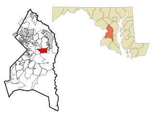
Largo, located within Greater Upper Marlboro, Maryland, is an unincorporated area and census-designated place in Prince George's County, Maryland, United States. The population was 11,605 at the 2020 census.

<span class="mw-page-title-main">Marlow Heights, Maryland</span> Census-designated place in Maryland, United States

Marlow Heights is an unincorporated area and census-designated place (CDP) in Prince George's County, Maryland, United States. The population was 6,169 at the 2020 census. The Marlow Heights Shopping Center first opened in 1957, adjacent to the large community of Hillcrest Heights. It was joined ten years later, in 1967, by the two-level Iverson Mall, the Washington metropolitan area's first enclosed mall.

<span class="mw-page-title-main">Marlton, Maryland</span> Census-designated place in Maryland

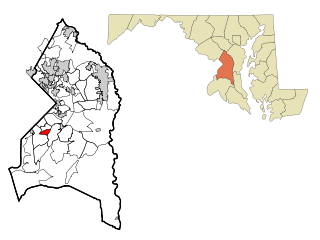
Marlton is an unincorporated area and census-designated place (CDP) in Prince George's County, Maryland, United States. The population was 9,802 at the 2020 census. The Marlton housing development, at first briefly called "Brandywine Country", grew up along U.S. Route 301 in the 1970s, and is part of the greater Upper Marlboro community. Originally made up of only single-family homes, more recently townhouses have been added.

<span class="mw-page-title-main">Mitchellville, Maryland</span> Census-designated place in Maryland

Mitchellville is a majority African-American unincorporated area and census-designated place (CDP) in Prince George's County, Maryland, United States. Per the 2020 census, the population was 11,136.

<span class="mw-page-title-main">Springdale, Maryland</span> Census-designated place in Maryland

Springdale is an unincorporated area and census-designated place (CDP) in Prince George's County, Maryland, United States. Per the 2020 census, the population was 5,301.

<span class="mw-page-title-main">Temple Hills, Maryland</span> Census-designated place in Maryland, United States

Temple Hills is an unincorporated area and census-designated place (CDP) in Prince George's County, Maryland, United States. Temple Hills borders the communities of Hillcrest Heights, Marlow Heights, Camp Springs and Oxon Hill. Per the 2020 census, the population was 8,350.

<span class="mw-page-title-main">West Laurel, Maryland</span> Census-designated place in Maryland

West Laurel is an unincorporated area and census-designated place (CDP) in Prince George's County, Maryland, United States. Per the 2020 census, the population was 4,428.

<span class="mw-page-title-main">Woodmore, Maryland</span> Census-designated place in Maryland

Woodmore is an unincorporated area and census-designated place in Prince George's County, Maryland, United States. Per the 2020 census, the population was 4,513. The CDP is located within the boundaries of Route 193 to the west, Church Road to the east, Route 214 to the south and Route 50 to the north. Woodmore Road runs east and west through the center. It contains a large gated community and country club, developments of Woodmore Meadows, and Woodmore South on the south side, as well as various other custom built homes and farmland.

<span class="mw-page-title-main">Calverton, Maryland</span> Census-designated place in Maryland, United States

Calverton is an unincorporated area and census-designated place located on the boundary between Montgomery and Prince George's counties, Maryland, in the United States. At the 2020 census, it had a population of 17,316.

Landover is an unincorporated community and census-designated place in Prince George's County, Maryland, United States. As of the 2020 census, it had a population of 25,998.

<span class="mw-page-title-main">Brock Hall, Maryland</span> Census-designated place in Maryland

Brock Hall is an unincorporated area and census-designated place in eastern Prince George's County, Maryland, United States, located south of Largo and Bowie, and north of Upper Marlboro. As of the 2020 census, the CDP had a population of 13,181.

Summerfield is a census-designated place near Landover in Prince George's County, Maryland. As of the 2020 census, the population was 14,758. It is a suburb of Washington, D.C.

Westphalia is a census-designated place in southern Prince George's County, Maryland, United States. The population of the CDP was 11,770 at the 2020 census.

References

  1. "2020 U.S. Gazetteer Files". United States Census Bureau. Retrieved April 26, 2022.
  2. U.S. Geological Survey Geographic Names Information System: Lake Arbor, Maryland
  3. "Lake Arbor CDP, Maryland". United States Census Bureau . Retrieved April 15, 2022.
  4. Zip Codes for Lake Arbor, Prince George's County, Maryland. Retrieved 2013-12-27.
  5. "1990 COUNTY BLOCK MAP" for Prince George's County (see index map). U.S. Census Bureau. Retrieved on September 9, 2018. Pages showing what is now Lake Arbor as being in Mitchellville are: 18 and 19.
  6. "CENSUS 2000 BLOCK MAP: LAKE ARBOR CDP." U.S. Census Bureau. Retrieved on September 9, 2018.
  7. Yorke, Jeffrey (October 24, 1987). "LAKE ARBOR COMES OF AGE". The Washington Post.
  8. Daily Record Staff (February 26, 2021). "Jon Laria".
  9. Wolfrom, Jessica (April 28, 2021). "Lake Arbor in Prince George's County prepares for change but remains tightknit". Washington Post.
  10. LeDuc, Daniel (April 6, 1999). "Glendening Plan Rewards His Backers". Washington Post.
  11. "Decennial Census of Population and Housing by Decades". US Census Bureau.
  12. 1 2 "P2 Hispanic or Latino, and Not Hispanic or Latino by Race – 2010: DEC Redistricting Data (PL 94-171) – Lake Arbor CDP, Maryland". United States Census Bureau .
  13. 1 2 "P2 Hispanic or Latino, and Not Hispanic or Latino by Race – 2020: DEC Redistricting Data (PL 94-171) – Lake Arbor CDP, Maryland". United States Census Bureau .
  14. "U.S. Census website". United States Census Bureau . Retrieved January 31, 2008.
  15. 1 2 3 4 5 "2010 CENSUS - CENSUS BLOCK MAP (INDEX): Lake Arbor CDP, MD." U.S. Census Bureau. Retrieved on September 1, 2018. Pages: 1 and 2.
  16. Contact Us." The Boulevard at the Capital Centre. Retrieved on September 9, 2018. "Boulevard at the Capital Centre 900 Capital Centre Boulevard Largo, MD 20774"
  17. Directory of Corporate Affiliations, Volume 5. National Register Pub. Co., 2001. 455. Retrieved on January 18, 2011. "CROWN BOOKS CORPORATION 1601 McCormick Dr. Largo, MD "
  18. "LARGO." U.S. Postal Service. Retrieved on September 11, 2018. "9801 APOLLO DR UPPER MARLBORO, MD 20774-9997"
  19. "NEIGHBORHOOD ELEMENTARY SCHOOLS AND BOUNDARIES SCHOOL YEAR 2018-2019." Prince George's County Public Schools. Retrieved on September 1, 2018.
  20. "NEIGHBORHOOD MIDDLE SCHOOLS AND BOUNDARIES SCHOOL YEAR 2018-2019." Prince George's County Public Schools. Retrieved on September 1, 2018.
  21. "NEIGHBORHOOD HIGH SCHOOLS AND BOUNDARIES SCHOOL YEAR 2018-2019." Prince George's County Public Schools. Retrieved on September 1, 2018.
  22. "Largo Town Center." Washington Metro. Retrieved on September 9, 2018. "9000 Lottsford Road Largo, MD 20774"