
Forestville is an unincorporated area and census-designated place (CDP) in Prince George's County, Maryland, United States. Per the 2020 census, the population was 12,831. The community is a mixture of garden apartments, single-family homes, and shopping centers built mostly from the 1930s through 1970s, adjacent to the communities of District Heights, Suitland, Morningside, Westphalia and Camp Springs.
Kettering is an unincorporated area and census-designated place in Prince George's County, Maryland, United States. At the 2020 United States Census, the population was 14,424,. Kettering is adjacent to Prince George's Community College, the upscale gated community of Woodmore, Six Flags America, Evangel Temple megachurch, and the community of Largo at the end of the Washington Metro Blue Line. Watkins Regional Park in Kettering offers a large playground, a colorful carousel, miniature golf, a miniature train ride, and various animals.

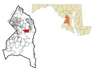
Marlton is an unincorporated area and census-designated place (CDP) in Prince George's County, Maryland, United States. The population was 9,802 at the 2020 census. The Marlton housing development, at first briefly called "Brandywine Country", grew up along U.S. Route 301 in the 1970s, and is part of the greater Upper Marlboro community. Originally made up of only single-family homes, more recently townhouses have been added.

Rosaryville is an unincorporated area and census-designated place (CDP) in Prince George's County, Maryland, United States, located south of Cinton and Upper Marlboro beside U.S. Route 301. Per the 2020 census, the population was 11,548. including housing developments and rural open space. It was named for a local Roman Catholic church. Close to Rosaryville are the Marlton housing development, Maryland Veterans Cemetery, the Southern Maryland Farmers Market, and Rosaryville State Park.

Springdale is an unincorporated area and census-designated place (CDP) in Prince George's County, Maryland, United States. Per the 2020 census, the population was 5,301.

Woodmore is an unincorporated area and census-designated place in Prince George's County, Maryland, United States. Per the 2020 census, the population was 4,513. The CDP is located within the boundaries of Route 193 to the west, Church Road to the east, Route 214 to the south and Route 50 to the north. Woodmore Road runs east and west through the center. It contains a large gated community and country club, developments of Woodmore Meadows, and Woodmore South on the south side, as well as various other custom built homes and farmland.

Calverton is an unincorporated area and census-designated place located on the boundary between Montgomery and Prince George's counties, Maryland, in the United States. At the 2020 census, it had a population of 17,316.
Lanham is an unincorporated community and census-designated place in Prince George's County, Maryland. As of the 2020 United States Census it had a population of 11,282. The New Carrollton station as well as an Amtrak station are across the Capital Beltway in New Carrollton, Maryland. Doctors Community Hospital is located in Lanham.
Queen Anne in Prince George's County, Maryland, United States, is a former port on the Patuxent River. It was delineated as a CDP for the 2010 census, at which time it had a population of 1,280. Per the 2020 census, the population was 1,405.
Silver Hill is an unincorporated community and census-designated place (CDP) in Prince George's County, Maryland, United States, approximately 1 mile (1.6 km) southeast of Washington, D.C. Per the 2020 census, the population was 6,381. Prior to 2010, Silver Hill was part of the Suitland-Silver Hill census-designated place.
Konterra is an unincorporated area and census-designated place (CDP) in Prince George's County, Maryland, United States. The population was 3,158 at the 2020 census.

Aquasco is an unincorporated area and census-designated place in southeastern Prince George's County, Maryland, United States, surrounding the town of Eagle Harbor and bordering Charles County. As of the 2020 census, the CDP had a population of 913. Aquasco was home to the Aquasco Speedway.

Baden is an unincorporated area and census-designated place in southeastern Prince George's County, Maryland, United States. As of the 2020 census, the CDP had a population of 2,114.

Brock Hall is an unincorporated area and census-designated place in eastern Prince George's County, Maryland, United States, located south of Largo and Bowie, and north of Upper Marlboro. As of the 2020 census, the CDP had a population of 13,181.
Cedarville is an unincorporated community and census-designated place in southern Prince George's County, Maryland, United States. As of the 2020 census the population was 639.
Fairwood is an unincorporated area and census-designated place (CDP) in Prince George's County, Maryland, United States. The population was 7,983 at the 2020 census.
Marlboro Village is an unincorporated community and census-designated place (CDP) in Prince George's County, Maryland, United States. Per the 2020 census, the population was 9,221.
Melwood is an unincorporated community and census-designated place (CDP) in Prince George's County, Maryland, United States. It was newly delineated for the 2010 census, at which time its population was 3,051. Per the 2020 census, the population was 3,977.
Queensland is a census-designated place south of Upper Marlboro in Prince George's County, Maryland, United States. The population of the CDP was 2,191 at the 2020 census. It was formerly known as Queenland until 2014 when its name was changed to Queensland and a small portion of its geography was transferred to Upper Marlboro.
Westphalia is a census-designated place in southern Prince George's County, Maryland, United States. The population of the CDP was 11,770 at the 2020 census.


