Edgewood, Maryland

Last updated
Edgewood, Maryland
Harford County Maryland Incorporated and Unincorporated areas Edgewood Highlighted.svg
Location of Edgewood, Maryland
Coordinates: 39°25′07″N76°17′40″W / 39.41861°N 76.29444°W / 39.41861; -76.29444 [1]
CountryUnited States
State Maryland
County Harford
Area
[2]
  Total17.24 sq mi (44.64 km2)
  Land17.10 sq mi (44.30 km2)
  Water0.13 sq mi (0.34 km2)
Elevation
[1]
52 ft (16 m)
Population
 (2020)
  Total25,713
  Density1,503.42/sq mi (580.46/km2)
Time zone UTC−5 (Eastern (EST))
  Summer (DST) UTC−4 (EDT)
ZIP Code
21040
Area code 410
FIPS code 24-25150

Edgewood is an unincorporated community and census-designated place (CDP) in Harford County, Maryland, United States. The population was 25,562 at the 2010 census, [3] up from 23,378 in 2000.

Contents

Geography

Edgewood is located in southwestern Harford County. It is bordered to the west by Baltimore County, Joppatowne, to the north by Bel Air South, to the east by the Bush River, an arm of Chesapeake Bay, to the south by the Edgewood Arsenal portion of Aberdeen Proving Ground, and to the southwest by the tidal Gunpowder River, another arm of the Chesapeake.

Interstate 95 forms the northern border of the Edgewood CDP and provides access from Exit 74 (Maryland Route 152) and Exit 77 (Maryland Route 24). I-95 leads southwest 25 miles (40 km) to Baltimore and northeast 50 miles (80 km) to Wilmington, Delaware. U.S. Route 40 (Pulaski Highway) runs through the northern part of Edgewood, parallel to I-95. US 40 leads southwest 9 miles (14 km) to White Marsh and the same distance northeast to Aberdeen. Maryland Route 24 begins at an entrance to Aberdeen Proving Ground in the southern part of the CDP and leads 10 miles (16 km) north to Bel Air, the Harford County seat.

According to the United States Census Bureau, the Edgewood CDP has a total area of 17.9 square miles (46.4 km2), of which 17.8 square miles (46.1 km2) are land and 0.2 square miles (0.4 km2), or 0.77%, are water. [3]

Demographics

Historical population
CensusPop.Note
2020 25,713
U.S. Decennial Census [4]
Edgewood station, which is served by MARC Train commuter rail service to Baltimore and Washington DC Northbound view, Edgewood MARC station.JPG
Edgewood station, which is served by MARC Train commuter rail service to Baltimore and Washington DC

As of the census [5] of 2000, there were 23,378 people, 8,299 households, and 6,224 families living in the CDP. The population density was 1,303.9 inhabitants per square mile (503.4/km2). There were 8,834 housing units at an average density of 492.7 per square mile (190.2/km2). The racial makeup of the CDP was 68.10% White, 25.66% African American, 0.40% Native American, 1.64% Asian, 0.09% Pacific Islander, 1.40% from other races, and 2.70% from two or more races. Hispanic or Latino of any race were 3.40% of the population.

There were 8,299 households, out of which 43.9% had children under the age of 18 living with them, 50.2% were married couples living together, 19.3% had a female householder with no husband present, and 25.0% were non-families. 19.6% of all households were made up of individuals, and 4.3% had someone living alone who was 65 years of age or older. The average household size was 2.81 and the average family size was 3.21.

In the CDP, the population was spread out, with 32.2% under the age of 18, 9.0% from 18 to 24, 33.0% from 25 to 44, 19.6% from 45 to 64, and 6.3% who were 65 years of age or older. The median age was 31 years. For every 100 females, there were 92.6 males. For every 100 females age 18 and over, there were 87.5 males.

The median income for a household in the CDP was $47,150, and the median income for a family was $50,276. Males had a median income of $36,076 versus $27,214 for females. The per capita income for the CDP was $17,943. About 8.5% of families and 10.3% of the population were below the poverty line including 14.8% of those under age 18 and 9.3% of those age 65 or over.

Education

The Harford County Board of Education, under the jurisdiction of the State of Maryland, provides services to educate the residents of Edgewood and its surrounding neighborhoods within the official boundaries established by the county. Edgewood has several elementary schools (Edgewood Elementary and Deerfield Elementary), a middle school (Edgewood Middle), and a newly rebuilt high school (Edgewood High School). Edgewood High School is home to two special magnet programs, the International Baccalaureate Diploma Program and the Academy of Finance.

There are several parochial schools in the Edgewood area including the Trinity Lutheran School, which is a Christian school that provides an education for students from Pre-K to the 8th grade. The Trinity Lutheran Christian School is a member of the Carbon Disclosure Project (CDP). In 2017 the school lost its right to participate in Maryland's school voucher program, Broadening Options and Opportunities for Students Today (BOOST), because it had maintained the right to prevent gay and lesbian students in the school's handbook.[ citation needed ]

Notable people

See also

Related Research Articles

<span class="mw-page-title-main">Harford County, Maryland</span> County in Maryland, United States

Harford County is located in the U.S. state of Maryland. As of the 2020 census, the population was 260,924. Its county seat is Bel Air. Harford County is included in the Baltimore-Columbia-Towson, MD Metropolitan Statistical Area, which is also included in the Washington-Baltimore-Arlington, DC-MD-VA-WV-PA Combined Statistical Area.

<span class="mw-page-title-main">LaVale, Maryland</span> Census-designated place in Maryland, United States

LaVale is a census-designated place (CDP) in Allegany County, Maryland, United States. It is part of the Cumberland, MD-WV Metropolitan Statistical Area. The population was 3,551 at the 2010 census.

<span class="mw-page-title-main">Lake Shore, Maryland</span> Census-designated place in Maryland, United States

Lake Shore is a census-designated place and unincorporated community in Anne Arundel County, Maryland, United States, located east of Pasadena. The population of Lake Shore was 19,477 at the 2010 census.

<span class="mw-page-title-main">Pasadena, Maryland</span> Census-designated place in Maryland, United States

Pasadena is a census-designated place (CDP) in Anne Arundel County, Maryland, United States. The population was 24,287 at the 2010 census.

<span class="mw-page-title-main">Carney, Maryland</span> Census-designated place in Maryland, United States

Carney is an unincorporated community and census-designated place in Baltimore County, Maryland, United States. The population was 29,941 at the 2010 census.

<span class="mw-page-title-main">Parkville, Maryland</span> Census-designated place in Maryland, United States

Parkville is an unincorporated community and census-designated place in Baltimore County, Maryland, United States. As of the 2010 census, the population was 30,734.

<span class="mw-page-title-main">Rosedale, Maryland</span> Census-designated place in Maryland, United States

Rosedale is an unincorporated community and census-designated place in Baltimore County, Maryland, United States. The population was 19,257 at the 2010 United States Census.

<span class="mw-page-title-main">Aberdeen, Maryland</span> City in Maryland, United States

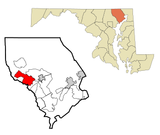
Aberdeen is a city located in Harford County, Maryland, United States, 26 miles (42 km) northeast of Baltimore. The population was 16,254 at the 2020 United States Census. Aberdeen is the largest municipality in Harford County.

<span class="mw-page-title-main">Bel Air North, Maryland</span> Census-designated place in Maryland, United States

Bel Air North is a census-designated place (CDP) in Harford County, Maryland, United States. It is situated immediately north of the incorporated town of Bel Air. As of the 2010 census, the CDP population was 30,568, up from 25,798 in 2000.

<span class="mw-page-title-main">Bel Air South, Maryland</span> Census-designated place in Maryland, United States

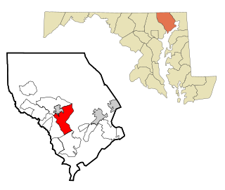
Bel Air South is a census-designated place (CDP) in Harford County, Maryland, United States. The population was 47,709 at the 2010 census, up from 39,711 in 2000.

<span class="mw-page-title-main">Fallston, Maryland</span> Census-designated place in Maryland, United States

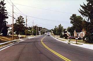
Fallston is a census-designated place (CDP) in Harford County, Maryland, United States. The population was 8,958 at the 2010 census, up from 8,427 in 2000. Fallston is a semi-rural community consisting mostly of farms and suburban-like developments.

<span class="mw-page-title-main">Perryman, Maryland</span> Census-designated place in Maryland, United States

Perryman is an unincorporated community and census-designated place (CDP) in Harford County, Maryland, United States. The population was 2,342 at the 2010 census.

<span class="mw-page-title-main">Pleasant Hills, Maryland</span> Census-designated place in Maryland, United States

Pleasant Hills is a census-designated place (CDP) in Harford County, Maryland, United States. The population was 3,379 at the 2010 census, up from 2,851 in 2000. There is no post office with the designation "Pleasant Hills"; most of the residents have either Fallston or Kingsville addresses and consider themselves as belonging to those communities.

<span class="mw-page-title-main">Riverside, Harford County, Maryland</span> Census-designated place in Maryland, United States

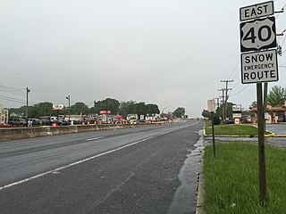
Riverside is a census-designated place (CDP) in Harford County, Maryland, United States. The population was 6,425 at the 2010 census. The term "Riverside" is generally used interchangeably with "Belcamp"; both names are accepted for the U.S. Postal Service's ZIP Code of 21017. However, the original community of Belcamp is located south of U.S. Route 40, outside the Riverside CDP.

<span class="mw-page-title-main">East Riverdale, Maryland</span> Census-designated place in Maryland

East Riverdale is an unincorporated area and census-designated place (CDP) in Prince George's County, Maryland, United States. The population was 18,459 at the 2020 census.

<span class="mw-page-title-main">Rosaryville, Maryland</span> Census-designated place in Maryland

Rosaryville is an unincorporated area and census-designated place (CDP) in Prince George's County, Maryland, United States, located south of Cinton and Upper Marlboro beside U.S. Route 301. Per the 2020 census, the population was 11,548. including housing developments and rural open space. It was named for a local Roman Catholic church. Close to Rosaryville are the Marlton housing development, Maryland Veterans Cemetery, the Southern Maryland Farmers Market, and Rosaryville State Park.

<span class="mw-page-title-main">Springdale, Maryland</span> Census-designated place in Maryland

Springdale is an unincorporated area and census-designated place (CDP) in Prince George's County, Maryland, United States. Per the 2020 census, the population was 5,301.

<span class="mw-page-title-main">Folsom, Pennsylvania</span> Census-designated place in Pennsylvania, United States

Folsom is a census-designated place (CDP) in Delaware County, Pennsylvania, United States. It is part of Ridley Township. The population was 8,323 at the 2010 census.

<span class="mw-page-title-main">Lakeland South, Washington</span> Census-designated place in Washington, United States

Lakeland South is a census-designated place (CDP) in King County, Washington, United States. The population was 11,574 at the 2010 census.

Aberdeen Proving Ground is a census-designated place (CDP) covering the residential population of the Aberdeen Proving Ground in Harford County, Maryland, United States. The population at the 2020 Census was 1,668.

References

  1. 1 2 U.S. Geological Survey Geographic Names Information System: Edgewood, Maryland
  2. "2020 U.S. Gazetteer Files". United States Census Bureau. Retrieved April 26, 2022.
  3. 1 2 "Geographic Identifiers: 2010 Demographic Profile Data (G001): Edgewood CDP, Maryland". American Factfinder. U.S. Census Bureau. Retrieved July 13, 2017.[ dead link ]
  4. "Census of Population and Housing". Census.gov. Retrieved June 4, 2016.
  5. "U.S. Census website". United States Census Bureau . Retrieved 2008-01-31.