Related Research Articles

Harford County is located in the U.S. state of Maryland. As of the 2020 census, the population was 260,924. Its county seat is Bel Air. Harford County is included in the Baltimore-Columbia-Towson, MD Metropolitan Statistical Area, which is also included in the Washington-Baltimore-Arlington, DC-MD-VA-WV-PA Combined Statistical Area.

Odenton is a census-designated place (CDP) in Anne Arundel County, Maryland, United States, located approximately 10–20 minutes from the state capital, Annapolis. The population was 37,132 at the 2010 census, up from 20,534 at the 2000 census. The town's population growth rate of 80.8% between 2000 and 2010 was the greatest of any town in western Anne Arundel County. Odenton is located west of Annapolis, south of Baltimore, and northeast of Washington.

Stewartstown is a borough in York County, Pennsylvania, United States. The population was 2,125 at the 2020 census.

Clarksville is an unincorporated community in Howard County, Maryland; the second highest-earning county in the United States according to the U.S. Census Bureau. The community is named for William Clark, a farmer who owned much of the land on which the community now lies and served as a postal stop that opened on the 4th of July 1851.

Millersville is an unincorporated community in Anne Arundel County, Maryland, United States. Population was 20,965 in 2015 based on American Community Survey data.

Lansdowne is a census-designated place in southern Baltimore County, Maryland, United States, located just south of Baltimore city. As of the 2010 census, it had a population of 8,409. At the 2000 census and earlier, the area was delineated as part of the Lansdowne-Baltimore Highlands CDP.

Oldtown is an unincorporated community and census-designated place (CDP) in Allegany County, Maryland, United States, along the North Branch Potomac River. As of the 2010 census it had a population of 86.
Ruxton and Riderwood are unincorporated communities in Baltimore County, Maryland, United States. They are sometimes considered a part of Towson and are part of Towson's census area.

Darlington is an unincorporated community and census-designated place in northeastern Harford County, Maryland, United States. The population was 409 at the 2010 census. The center of the community was listed on the National Register of Historic Places as the Darlington Historic District in 1987. Median household income is $66,563. The percentage of people in poverty is 5.3%.

Churchville is an unincorporated community in Harford County, Maryland, United States, situated between the county seat, Bel Air, and Aberdeen, where Aberdeen Proving Ground is located.
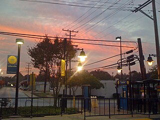
Lutherville is a census-designated place (CDP) in Baltimore County, Maryland, United States. As of the 2010 census it had a population of 6,504. Prior to 2010 the area was part of the Lutherville-Timonium CDP. Within its borders lies the Lutherville Historic District.

Conowingo is a community in western Cecil County, Maryland, United States.
Cardiff is an unincorporated community in Harford County, Maryland, United States. The zip code for the area is 21160. The community name is taken from the Capital city of Wales.
Highland is an unincorporated community and census-designated place in Howard County, Maryland, United States. As of the 2010 census it had a population of 1,034. It uses the 20777 zip code.
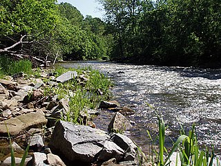
Deer Creek is a 52.9-mile-long (85.1 km) river in Maryland and Pennsylvania that flows through the scenic areas of Harford County and empties into the Susquehanna River, roughly halfway between the Interstate 95 bridge and Conowingo Dam. Its watershed area is 171 square miles (440 km2). Its watershed area in MD is 145 square miles (380 km2), with 3% impervious surface in 1994. It serves as a divider between the agricultural and urban/suburban areas of Harford County.

Abingdon is a census-designated place in Harford County, Maryland, United States. It lies 25 miles (40 km) northeast of Baltimore on Maryland Route 7, near the Bush River, between Exits 77 and 80 of Interstate 95.

Lauraville is a neighborhood in northeast Baltimore, Maryland. The neighborhood is bounded on the east by Harford Road, on the north by Echodale Avenue, on the south by Argonne Drive and Herring Run Park, and on the west side by Morgan Park and Morgan State University, with East Cold Spring Lane passing through the center of Lauraville.

Forest Hill is an unincorporated community in Harford County, Maryland, United States, located north of the county seat of Bel Air. The main part of town is located at the intersection of Maryland Route 24 and Jarrettsville Road. Until 1958, this community was served by the Maryland and Pennsylvania Railroad at milepost 30.3.
Whiteford is an unincorporated community in Harford County, Maryland, United States. The community has historically had a strong Welsh heritage, which is reflected in the local architecture.

Glyndon is an unincorporated community in Baltimore County, Maryland, United States. Founded in 1871 by Dr. Charles A. Leas, the village is located in the northwest section of Baltimore County and is primarily a residential suburb of metropolitan Baltimore City. The village is characterized by the predominance of historic Victorian homes and a strong sense of community among its residents. Glyndon is listed on the National Register of Historic Places (1973) and on the Maryland Inventory of Historic Properties (1973); the Glyndon Historic District was also designated as the first historic district in Baltimore County (1981).
References
- Wright, C. Milton (January 1, 1967). Our Harford Heritage: A History of Harford County, Maryland. by the author.
- Maryland and Pennsylvania Railroad Preservation Society
