Perryman, Maryland

Last updated
Perryman, Maryland
Harford County Maryland Incorporated and Unincorporated areas Perryman Highlighted.svg
Location of Perryman, Maryland
Coordinates: 39°28′7″N76°12′47″W / 39.46861°N 76.21306°W / 39.46861; -76.21306 Coordinates: 39°28′7″N76°12′47″W / 39.46861°N 76.21306°W / 39.46861; -76.21306
CountryUnited States
State Maryland
County Harford
Area
[1]
  Total5.54 sq mi (14.36 km2)
  Land5.48 sq mi (14.20 km2)
  Water0.06 sq mi (0.16 km2)
Elevation
39 ft (12 m)
Population
 (2020)
  Total2,496
  Density455.31/sq mi (175.78/km2)
Time zone UTC−5 (Eastern (EST))
  Summer (DST) UTC−4 (EDT)
ZIP code
21130
Area code 410
FIPS code 24-61075
GNIS feature ID0590998

Perryman is an unincorporated community and census-designated place (CDP) in Harford County, Maryland, United States. The population was 2,342 at the 2010 census. [2]

Contents

History

St. George's Parish Vestry House was listed on the National Register of Historic Places in 1976. [3] Amtrak's Northeast Corridor high-speed rail line runs through the community; however, Amtrak and MARC trains do not stop as there is no station.

Geography

Perryman is located in southern Harford County at 39°28′7″N76°12′47″W / 39.46861°N 76.21306°W / 39.46861; -76.21306 (39.468509, 76.213090). [4] It is bordered to the west by Church Creek and the Bush River, an arm of Chesapeake Bay; to the south by Sod Run, an inlet of the Bush River; to the east by Chelsea Road and Aberdeen Proving Ground; and to the north by the city of Aberdeen. The community of Riverside touches the northwest side of Perryman.

U.S. Route 40 (Pulaski Highway) runs through the northern part of Perryman, leading northeast 23 miles (37 km) to Elkton and southwest 27 miles (43 km) to downtown Baltimore.

According to the United States Census Bureau, the Perryman CDP has a total area of 5.6 square miles (14.5 km2), of which 5.5 square miles (14.3 km2) is land and 0.1 square miles (0.2 km2), or 1.08%, are water. [2]

Climate

The climate in this area is characterized by hot, humid summers and generally mild to cool winters. According to the Köppen Climate Classification system, Perryman has a humid subtropical climate, abbreviated "Cfa" on climate maps. [5]

Demographics

Historical population
CensusPop.
2020 2,496
U.S. Decennial Census [6]

As of the census [7] of 2000, there were 2,461 people, 960 households, and 696 families residing in the CDP. The population density was 450.2 inhabitants per square mile (173.8/km2). There were 1,024 housing units at an average density of 187.3 per square mile (72.3/km2). The racial makeup of the CDP was 71.76% White, 24.42% African American, 0.24% Native American, 0.81% Asian, 0.69% from other races, and 2.07% from two or more races. Hispanic or Latino of any race were 2.64% of the population.

There were 960 households, out of which 37.5% had children under the age of 18 living with them, 47.0% were married couples living together, 21.5% had a female householder with no husband present, and 27.5% were non-families. 21.9% of all households were made up of individuals, and 6.1% had someone living alone who was 65 years of age or older. The average household size was 2.55 and the average family size was 2.94.

In the CDP, the population was spread out, with 28.7% under the age of 18, 7.5% from 18 to 24, 29.7% from 25 to 44, 23.0% from 45 to 64, and 11.1% who were 65 years of age or older. The median age was 36 years. For every 100 females, there were 88.4 males. For every 100 females age 18 and over, there were 83.3 males.

The median income for a household in the CDP was $33,972, and the median income for a family was $40,938. Males had a median income of $35,979 versus $24,944 for females. The per capita income for the CDP was $17,236. About 17.5% of families and 17.4% of the population were below the poverty line, including 29.4% of those under age 18 and 2.9% of those age 65 or over.

Related Research Articles

<span class="mw-page-title-main">Ferndale, Maryland</span> Census-designated place in Maryland, United States

Ferndale is a census-designated place (CDP) in Anne Arundel County, Maryland, United States. At the 2010 census, the population was 16,746.

<span class="mw-page-title-main">Riviera Beach, Maryland</span> Census-designated place in Maryland, United States

Riviera Beach is a census-designated place in Anne Arundel County, Maryland, United States. The population was 12,677 at the 2010 U.S. census.

<span class="mw-page-title-main">South Gate, Maryland</span> Former census-designated place in Maryland, United States

South Gate was a census-designated place (CDP) in Anne Arundel County, Maryland, United States, for the 2000 census, at which time its population was 28,672. It was added primarily to the Glen Burnie CDP for the 2010 census.

<span class="mw-page-title-main">Carney, Maryland</span> Census-designated place in Maryland, United States

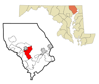
Carney is an unincorporated community and census-designated place in Baltimore County, Maryland, United States. The population was 29,941 at the 2010 census.

<span class="mw-page-title-main">Edgemere, Maryland</span> Census-designated place in Maryland, United States

Edgemere is an unincorporated community and census-designated place in Baltimore County, Maryland, United States. The population was 8,669 at the 2010 census. Founded in 1899 as Edgemere being renamed from previous name "Fitzell". Meeting held at the Fitzell Farm which was situated where the old Rheem plant was located.

<span class="mw-page-title-main">Lochearn, Maryland</span> Census-designated place in Maryland, United States

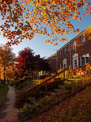
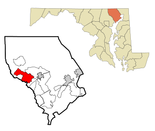
Lochearn is an unincorporated community and census-designated place in Baltimore County, Maryland, United States, located immediately to the west of the City of Baltimore. Per the 2020 census, the population was 25,511.

<span class="mw-page-title-main">Milford Mill, Maryland</span> Census-designated place in Maryland, United States

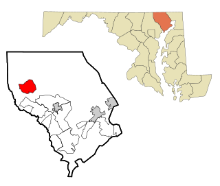
Milford Mill is an unincorporated community and census-designated place in Baltimore County, Maryland, United States. Per the 2020 census, the population was 30,622.

<span class="mw-page-title-main">Parkville, Maryland</span> Census-designated place in Maryland, United States

Parkville is an unincorporated community and census-designated place in Baltimore County, Maryland, United States. As of the 2010 census, the population was 30,734.

<span class="mw-page-title-main">Rossville, Maryland</span> Census-designated place in Maryland, United States

Rossville is an unincorporated community and census-designated place in Baltimore County, Maryland, United States. The population was 15,147 at the 2010 census.

<span class="mw-page-title-main">Dunkirk, Maryland</span> Census-designated place in Maryland, United States

Dunkirk is a census-designated place (CDP) in Calvert County, Maryland, United States. The population was 2,521 at the 2010 census.

<span class="mw-page-title-main">Aberdeen, Maryland</span> City in Maryland, United States

Aberdeen is a city located in Harford County, Maryland, United States, 26 miles (42 km) northeast of Baltimore. The population was 16,254 at the 2020 United States Census. Aberdeen is the largest municipality in Harford County.

<span class="mw-page-title-main">Bel Air North, Maryland</span> Census-designated place in Maryland, United States

Bel Air North is a census-designated place (CDP) in Harford County, Maryland, United States. It is situated immediately north of the incorporated town of Bel Air. As of the 2010 census, the CDP population was 30,568, up from 25,798 in 2000.

<span class="mw-page-title-main">Bel Air South, Maryland</span> Census-designated place in Maryland, United States

Bel Air South is a census-designated place (CDP) in Harford County, Maryland, United States. The population was 47,709 at the 2010 census, up from 39,711 in 2000.

<span class="mw-page-title-main">Edgewood, Maryland</span> Census-designated place in Maryland, United States

Edgewood is an unincorporated community and census-designated place (CDP) in Harford County, Maryland, United States. The population was 25,562 at the 2010 census, up from 23,378 in 2000.

<span class="mw-page-title-main">Fallston, Maryland</span> Census-designated place in Maryland, United States

Fallston is a census-designated place (CDP) in Harford County, Maryland, United States. The population was 8,958 at the 2010 census, up from 8,427 in 2000. Fallston is a semi-rural community consisting mostly of farms and suburban-like developments.

<span class="mw-page-title-main">Jarrettsville, Maryland</span> Census-designated place in Maryland, United States

Jarrettsville is an unincorporated community and census-designated place (CDP) in Harford County, Maryland, United States. The population was 2,888 at the 2020 census.

<span class="mw-page-title-main">Pleasant Hills, Maryland</span> Census-designated place in Maryland, United States

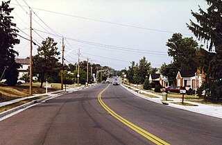
Pleasant Hills is a census-designated place (CDP) in Harford County, Maryland, United States. The population was 3,379 at the 2010 census, up from 2,851 in 2000. There is no post office with the designation "Pleasant Hills"; most of the residents have either Fallston or Kingsville addresses and consider themselves as belonging to those communities.

<span class="mw-page-title-main">Riverside, Harford County, Maryland</span> Census-designated place in Maryland, United States

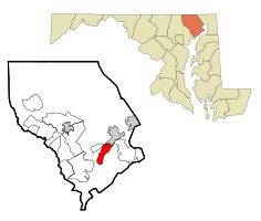
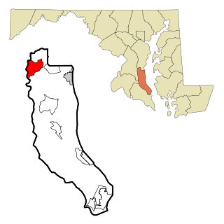
Riverside is a census-designated place (CDP) in Harford County, Maryland, United States. The population was 6,425 at the 2010 census. The term "Riverside" is generally used interchangeably with "Belcamp"; both names are accepted for the U.S. Postal Service's ZIP Code of 21017. However, the original community of Belcamp is located south of U.S. Route 40, outside the Riverside CDP.

<span class="mw-page-title-main">Cloverly, Maryland</span> Census-designated place in Maryland, United States

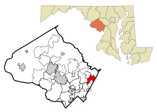
Cloverly is an unincorporated town and census-designated place in Montgomery County, Maryland, United States. Its population was 15,285 as of the 2020 census.

<span class="mw-page-title-main">Fairland, Maryland</span> Census-designated place in Maryland, United States

Fairland is a census-designated place and an unincorporated area in Montgomery County, Maryland, United States. It had a population of 25,396 per the 2020 census.

References

  1. "2020 U.S. Gazetteer Files". United States Census Bureau. Retrieved April 26, 2022.
  2. 1 2 "Geographic Identifiers: 2010 Demographic Profile Data (G001): Perryman CDP, Maryland". American Factfinder. U.S. Census Bureau. Retrieved July 13, 2017.[ dead link ]
  3. "National Register Information System". National Register of Historic Places . National Park Service. April 15, 2008.
  4. "US Gazetteer files: 2010, 2000, and 1990". United States Census Bureau. 2011-02-12. Retrieved 2011-04-23.
  5. Climate Summary for Perryman, Maryland
  6. "Census of Population and Housing". Census.gov. Retrieved June 4, 2016.
  7. "U.S. Census website". United States Census Bureau . Retrieved 2008-01-31.