Greenhills, Ohio

Last updated

Greenhills
Greenhills Ohio Municipal Building.JPG
Greenhills Ohio Municipal Building
Motto: 
"Pioneering a Dream"
Hamilton County Ohio Incorporated and Unincorporated areas Greenhills highlighted.svg
Location in Hamilton County and the state of Ohio.
Coordinates: 39°16′01″N84°31′10″W / 39.26694°N 84.51944°W / 39.26694; -84.51944
Country United States
State Ohio
County Hamilton
Government
  MayorDavid Moore (R) [1]
Area
[2]
  Total1.24 sq mi (3.22 km2)
  Land1.24 sq mi (3.22 km2)
  Water0.00 sq mi (0.00 km2)
Elevation
[3]
801 ft (244 m)
Population
 (2020)
  Total3,741
  Density3,007.23/sq mi (1,160.88/km2)
Time zone UTC-5 (Eastern (EST))
  Summer (DST) UTC-4 (EDT)
ZIP code
45218
Area code 513
FIPS code 39-32158 [4]
GNIS feature ID1086213 [3]
Website www.greenhillsohio.us

Greenhills is a village in Hamilton County, Ohio, United States. The population was 3,741 at the 2020 census. A planned community, it was established by the United States government during the Great Depression. Most of the village is a National Historic Landmark for its history as a planned modernist community. [5]

Contents

History

Greenhills in February 1938 CH-NB - USA, Greenhills-OH- Resettlement Project - Annemarie Schwarzenbach - SLA-Schwarzenbach-A-5-10-103.jpg
Greenhills in February 1938

As one of three Greenbelt Communities built by the Resettlement Administration during the 1930s (the other two are Greenbelt, Maryland and Greendale, Wisconsin [6] [7] [8] ), Greenhills was designed to be surrounded by a "belt" of woodland and natural landscaping. Like the other six "FDR towns", Greenhills was founded as a sundown town, using restrictive covenants to prevent minorities from purchasing homes there. [9] [10] Many families include third- and fourth-generation descendants of the village's original "pioneers" who occupied the original International-style townhomes. The original government-built area, the Greenhills Historic District, is listed on the National Register of Historic Places [11] and is a National Historic Landmark. [12] The community's James Whallon House, which serves as the village hall is also listed in the National Register of Historic Places. [13] [14] The landmarked area encompasses about three quarters of the area within the village bounds, excepting only the northeastern section northeast of Farragut and Ingram Roads. [15]

Geography

According to the United States Census Bureau, the village has a total area of 1.25 square miles (3.24 km2), all land. [16]

Demographics

Historical population
CensusPop.Note
1940 2,677
1950 3,00512.3%
1960 5,40779.9%
1970 6,09212.7%
1980 4,927−19.1%
1990 4,393−10.8%
2000 4,103−6.6%
2010 3,615−11.9%
2020 3,7413.5%
U.S. Decennial Census [17]

2020 census

As of the census of 2020, there were 3,741 people living in the village, for a population density of 3,007.23 people per square mile (1,160.88/km2). There were 1,618 housing units. The racial makeup of the village was 73.2% White, 15.0% Black or African American, 0.2% Native American, 0.9% Asian, 0.0% Pacific Islander, 2.2% from some other race, and 8.5% from two or more races. 5.0% of the population were Hispanic or Latino of any race. [18]

There were 1,409 households, out of which 33.6% had children under the age of 18 living with them, 35.6% were married couples living together, 17.9% had a male householder with no spouse present, and 36.3% had a female householder with no spouse present. 33.2% of all households were made up of individuals, and 10.8% were someone living alone who was 65 years of age or older. The average household size was 2.58, and the average family size was 3.39. [18]

28.4% of the village's population were under the age of 18, 57.6% were 18 to 64, and 14.0% were 65 years of age or older. The median age was 37.8. For every 100 females, there were 104.8 males. [18]

According to the U.S. Census American Community Survey, for the period 2016-2020 the estimated median annual income for a household in the village was $69,208, and the median income for a family was $80,625. About 10.7% of the population were living below the poverty line, including 14.5% of those under age 18 and 9.0% of those age 65 or over. About 62.0% of the population were employed, and 31.9% had a bachelor's degree or higher. [18]

2010 census

As of the census [19] of 2010, there were 3,615 people, 1,499 households, and 968 families residing in the village. The population density was 2,892.0 inhabitants per square mile (1,116.6/km2). There were 1,645 housing units at an average density of 1,316.0 per square mile (508.1/km2). The racial makeup of the village was 88.0% White, 6.7% African American, 0.1% Native American, 0.8% Asian, 0.1% Pacific Islander, 0.7% from other races, and 3.6% from two or more races. Hispanic or Latino of any race were 2.4% of the population.

There were 1,499 households, of which 30.5% had children under the age of 18 living with them, 46.0% were married couples living together, 14.0% had a female householder with no husband present, 4.6% had a male householder with no wife present, and 35.4% were non-families. 30.3% of all households were made up of individuals, and 9.9% had someone living alone who was 65 years of age or older. The average household size was 2.37 and the average family size was 2.95.

The median age in the village was 39 years. 23.8% of residents were under the age of 18; 7.1% were between the ages of 18 and 24; 26.2% were from 25 to 44; 27% were from 45 to 64; and 16% were 65 years of age or older. The gender makeup of the village was 47.2% male and 52.8% female.

Education

Greenhills is served by the Winton Woods City School District and a branch of the Public Library of Cincinnati and Hamilton County. [20]

See also

Related Research Articles

<span class="mw-page-title-main">Hamilton County, Ohio</span> County in Ohio, United States

Hamilton County is located in the southwestern corner of the U.S. state of Ohio. As of the 2020 census, the population was 830,639, making it the third-most populous county in Ohio. The county seat and largest city is Cincinnati. The county is named for the first Secretary of the Treasury, Alexander Hamilton. Hamilton County is part of the Cincinnati-Middletown, OH-KY-IN Metropolitan Statistical Area.

<span class="mw-page-title-main">Kingsford Heights, Indiana</span> Town in Indiana, United States

Kingsford Heights is a town in Union Township, LaPorte County, Indiana, United States. The population was 1,335 at the 2020 census. It is included in the Michigan City, Indiana-La Porte, Indiana Metropolitan Statistical Area. Also known as "Victory City," the town was built by the United States government for workers that worked in the Kingsbury Ordnance Plant, an ammunitions plant that served the US during World War II and later the Korean War.

<span class="mw-page-title-main">Greenbelt, Maryland</span> City in Maryland, United States

Greenbelt is a city in Prince George's County, Maryland, United States, and a suburb of Washington, D.C. At the 2020 census, the population was 24,921.

<span class="mw-page-title-main">Millville, Ohio</span> Village in Ohio, United States

Millville is a village in Butler County, Ohio, United States. The population was 634 at the 2020 census. Millville sits between Oxford, Ohio and Cincinnati, Ohio along U.S. Route 27.

<span class="mw-page-title-main">Forest Park, Ohio</span> City in Ohio, United States

Forest Park is the second most populous city in Hamilton County, Ohio, United States. It is a suburb of Cincinnati. The population was 20,189 at the 2020 census.

<span class="mw-page-title-main">Glendale, Ohio</span> Village in Ohio, United States

Glendale is a village in Hamilton County, Ohio, United States. The population was 2,298 at the 2020 census. It is a northern suburb of Cincinnati, and is the site of the Glendale Historic District.

<span class="mw-page-title-main">Harrison, Ohio</span> City in Ohio, United States

Harrison is a city in western Hamilton County, Ohio, United States. The population was 12,563 at the 2020 census. It is part of the Cincinnati metropolitan area.

<span class="mw-page-title-main">Mariemont, Ohio</span> Village in Ohio, United States

Mariemont is a village in eastern Hamilton County, Ohio, United States. The population was 3,518 at the 2020 census. A planned community in the Cincinnati metropolitan area, it includes two overlapping historic districts, the Village of Mariemont and Mariemont Historic District. In 2007, the Village of Mariemont was designated a National Historic Landmark.

<span class="mw-page-title-main">Mount Healthy, Ohio</span> City in Ohio, United States

Mount Healthy is a city in Hamilton County, Ohio, United States. It is a suburb of Cincinnati. The population was 6,996 at the 2020 census.

<span class="mw-page-title-main">Newtown, Ohio</span> Village in Ohio, United States

Newtown is a village in southeastern Hamilton County, Ohio, United States, near Cincinnati. The population was 2,702 at the 2020 census. Newtown was settled in 1792 and incorporated as a village in 1901.

<span class="mw-page-title-main">North College Hill, Ohio</span> City in Ohio, United States

North College Hill is a city in Hamilton County in the southwestern part of the U.S. state of Ohio approximately ten miles north of downtown Cincinnati. As of the 2020 census, the city population was 9,663. The city takes its name from its proximity to the Cincinnati neighborhood of College Hill which borders it to the south.

<span class="mw-page-title-main">Reading, Ohio</span> City in Ohio, United States

Reading is a city in Hamilton County, Ohio, United States. The population was 10,600 at the 2020 census. It is an inner suburb of Cincinnati and is included as part of the Cincinnati metropolitan area.

<span class="mw-page-title-main">St. Bernard, Ohio</span> Village in Ohio, United States

St. Bernard or Saint Bernard is a village in Hamilton County, Ohio, United States. It is an enclave and suburb of Cincinnati. The population was 4,070 at the 2020 census.

<span class="mw-page-title-main">Wyoming, Ohio</span> City in Ohio, United States

Wyoming is a city in Hamilton County, Ohio; located approximately 12 miles north of downtown Cincinnati and part of the Cincinnati metropolitan area. The population was 8,756 at the 2020 census.

<span class="mw-page-title-main">Eleanor, West Virginia</span> Town in West Virginia, United States

Eleanor is a town in Putnam County, West Virginia, United States, along the Kanawha River. Its population was 1,548 at the 2020 census. It is part of the Huntington–Ashland metropolitan area. The town, named for Eleanor Roosevelt, was established as a New Deal project in the 1930s like other Franklin D. Roosevelt towns around the nation.

<span class="mw-page-title-main">Greendale, Wisconsin</span> Village in Wisconsin, United States

Greendale is a village in Milwaukee County, Wisconsin, United States. The population was 14,854 at the 2020 census. Greendale is located southwest of Milwaukee, Wisconsin, and is a part of the Milwaukee metropolitan area. A planned community, it was established by the United States government during the Great Depression.

<span class="mw-page-title-main">Sharonville, Ohio</span> City in Ohio, United States

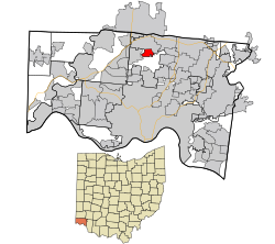
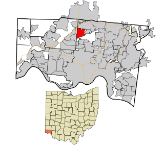
Sharonville is a city largely in Hamilton County in the U.S. state of Ohio. The population was 14,117 at the 2020 census.

<span class="mw-page-title-main">Miamitown, Ohio</span> Census-designated place in Ohio, United States

Miamitown is a census-designated place (CDP) in western Whitewater Township, Hamilton County, Ohio, United States. The population was 1,256 at the 2020 census. It has a post office with the ZIP code 45041.

<span class="mw-page-title-main">Greendale Historic District</span> Historic district in Wisconsin, United States

The Greendale Historic District is a National Historic Landmark District encompassing the historic core of the village of Greendale, Wisconsin. The village core was designed in the 1930s as part of a New Deal program to establish so-called "greenbelt towns" as model suburbs, and is one of three such communities built by the federal government. It was added to the National Register of Historic Places in 2005 and designated as a National Historic Landmark in 2012.

<span class="mw-page-title-main">New Burlington, Hamilton County, Ohio</span> Census-designated place in Ohio, United States

New Burlington is a census-designated place (CDP) in Springfield Township, Hamilton County, Ohio, United States. The population was 5,049 at the 2020 census.

References

  1. "Hamilton County Officials 2016" (PDF). Hamilton County Board of Elections. January 27, 2016. p. 34. Archived (PDF) from the original on January 26, 2022. Retrieved February 1, 2016.
  2. "ArcGIS REST Services Directory". United States Census Bureau. Archived from the original on January 19, 2022. Retrieved September 20, 2022.
  3. 1 2 U.S. Geological Survey Geographic Names Information System: Greenhills, Ohio
  4. "U.S. Census website". United States Census Bureau. Archived from the original on May 12, 2015. Retrieved January 31, 2008.
  5. "Why a Utopian Town Is Demolishing Its Own History". Bloomberg. January 31, 2018. Archived from the original on March 14, 2021. Retrieved March 19, 2023 via www.bloomberg.com.
  6. Halpern, Sue (May–June 2002), "New Deal City", Mother Jones , archived from the original on February 16, 2009, retrieved July 7, 2007
  7. "Greendale Originals - The shops, history and events in the Village of Greendale, Wisconsin". Archived from the original on February 7, 2012.
  8. https://etd.ohiolink.edu/rws_etd/document/get/ucin1223302164/inline Archived December 30, 2016, at the Wayback Machine [ bare URL ]
  9. Loewen, James W. (2013). "Hidden in Plain View: Knowing and Not Knowing About Sundown Towns". Sundown Towns: A Hidden Dimension Of American Racism. The New Press. p. 239. ISBN   978-1595586742. In 1917, in Buchanan v. Warley , the U.S. Supreme Court held the Louisville [housing segregation, block-by-city-block] ordinance unconstitutional (p.101)...[Yet] during the Depression the federal government acted as if Buchanan did not exist when it set up at least seven towns-- Richland, Washington; Boulder City, Nevada; Norris, Tennessee; Greendale, Wisconsin; Greenhills, Ohio; Arthurdale, West Virginia; and Greenbelt, Maryland-- that explicitly kept out African Americans (p.103)... progress [toward integration] has been real but uneven (p.416)... America's seven FDR towns, all sundown from the start, exemplify this unevenness. Greenbelt, Maryland is now 41% black, while Greenhills, Ohio, is 2.6% black (p.515).
  10. Fairbanks, Robert B. (Winter 1978). "Cincinnati and Greenhills: The Response to a Federal Community, 1935–1939" (PDF). Cincinnati Historical Society Bulletin. 36 (4): 239. Archived from the original (PDF) on February 17, 2019. Retrieved February 17, 2019. Eager for the new town to be accepted not only by these few but by the entire metropolitan community, federal officials dedicated themselves to abiding by 'community standards' in their new town. As a result, the suburban town project which had been planned for the needy, ignored the neediest. Although the two chief administrators of the greenbelts, Rexford G. Tugwell and Will W. Alexander, believed in equal benefits for blacks, prejudice prevailed and blacks were excluded from Greenhills.
  11. Rozhon, Tracie (February 9, 2009). "New Deal Architecture Faces Bulldozer". The New York Times. Archived from the original on February 2, 2017. Retrieved February 24, 2017 via NYTimes.com.
  12. Milam, Brett. "Greenhills named a National Historic Landmark". The Enquirer. Archived from the original on June 1, 2023. Retrieved March 19, 2023.
  13. "National Register Information System". National Register of Historic Places . National Park Service. March 13, 2009.
  14. Village of Greenhills, Ohio Archived January 9, 2004, at the Wayback Machine , Village of Greenhills, n.d. Accessed November 17, 2009.
  15. "NHL nomination for Greenhills Historic District" (PDF). National Park Service. Archived (PDF) from the original on July 10, 2017. Retrieved March 2, 2018.
  16. "US Gazetteer files 2010". United States Census Bureau. Archived from the original on January 25, 2012. Retrieved January 6, 2013.
  17. "Census of Population and Housing". Census.gov. Archived from the original on April 26, 2015. Retrieved June 4, 2015.
  18. 1 2 3 4 "Greenhills village, Ohio - Census Bureau Profile". United States Census Bureau. Retrieved October 16, 2023.
  19. "American FactFinder". United States Census Bureau. Archived from the original on February 2, 2017. Retrieved January 6, 2013.
  20. "Greenhills Branch". Public Library of Cincinnati and Hamilton County. Archived from the original on June 25, 2014. Retrieved June 12, 2014.