Arnold, Maryland

Last updated

Arnold, Maryland
2016-08-17 07 54 41 View north along Maryland State Route 648 (Baltimore-Annapolis Boulevard) just north of Maryland State Route 2 (Governor Ritchie Highway) in Arnold, Anne Arundel County, Maryland.jpg
Baltimore-Annapolis Boulevard in Arnold
Anne Arundel County Maryland Incorporated and Unincorporated areas Arnold Highlighted.svg
Location of Arnold, Maryland
Coordinates: 39°01′55″N76°30′10″W / 39.03194°N 76.50278°W / 39.03194; -76.50278
CountryFlag of the United States.svg United States
State Flag of Maryland.svg  Maryland
County Flag of Anne Arundel County, Maryland.png Anne Arundel
Area
[1]
  Total13.56 sq mi (35.11 km2)
  Land10.82 sq mi (28.02 km2)
  Water2.74 sq mi (7.09 km2)
Elevation
128 ft (39 m)
Population
 (2020)
  Total24,064
  Density2,224.24/sq mi (858.80/km2)
Time zone UTC−5 (Eastern (EST))
  Summer (DST) UTC−4 (EDT)
ZIP code
21012
Area code 410
FIPS code 24-02275
GNIS feature ID582920 [2]

Arnold, a census-designated place (CDP) in Anne Arundel County, Maryland, United States, located just outside of the state's capital, Annapolis. It is located 18.78 miles south of Baltimore, [3] and 29.97 miles east of Washington, D.C. [4] The population was 23,106 at the 2010 census. [5] Neighborhoods straddle College Parkway and Maryland Route 2 (Ritchie Highway). Arnold is located on the scenic Broadneck Peninsula. The ZIP code is 21012. It is bordered by Severna Park to the northwest, Cape Saint Claire to the southeast, Annapolis to the southwest, and Lake Shore (a CDP within Pasadena) to the northeast.

Contents

History

Native Americans are known to have resided in the region in pre-Columbian times based on artifacts found in the Ulmstead Point area dating back to the Archaic period (5000–1500 BC). Later tribes that have been in the area include the Algonquin tribes, among others. However, when Captain John Smith arrived in the area in 1608, he reported no Natives.

The early settlement of Arnold, an area between the Magothy and Severn rivers, began with the farm of John Arnold. He was a veteran of the War of 1812, who acquired 300 acres (1.2 km2) on the north side of the Severn River. [6] One of his sons, Thomas Arnold, inherited the land, later working as the local station master for the Baltimore and Annapolis Short Line Railroad. [7]

Residents know the area to have been home to a racetrack in the present-day Revell-Downs planned community and even a rollercoaster and boardwalk in Mago Vista Beach. [8]

Education

Children in Arnold are served by the following public schools in the Anne Arundel County Public Schools district:

Elementary schools:

Middle schools:

High school:

Private schools:

Post-secondary:

Geography

Arnold is located at 39°2′50″N76°29′48″W / 39.04722°N 76.49667°W / 39.04722; -76.49667 (39.047263, −76.496552). [9] It is 5 miles (8 km) north of Annapolis, the state capital, and 24 miles (39 km) south of downtown Baltimore.

According to the United States Census Bureau, the CDP has a total area of 13.6 square miles (35.1 km2), of which 10.8 square miles (28.0 km2) is land and 2.7 square miles (7.1 km2), or 20.18%, is water, consisting of the tidal Severn (to the southwest) and Magothy (to the northeast) rivers.

Demographics

Historical population
CensusPop.Note
2020 24,064
U.S. Decennial Census [10]

As of the census [11] of 2010, there were 23,106 people, 8,373 households, and 6,396 families residing in the CDP. The population density was 2,168.7 inhabitants per square mile (837.3/km2). There were 8,623 housing units at an average density of 798.4 per square mile (308.3/km2). The racial makeup of the CDP was 88.65% White, 5.23% African American, 0.23% Native American, 2.41% Asian, 0.03% Pacific Islander, 1.16% from other races, and 2.28% from two or more races. Hispanic or Latino of any race were 3.97% of the population.

There were 8,373 households, of which 40.2% had children under the age of 18 living with them; 63.8% were married couples living together, 9.5% had a female householder with no husband present, and 23.6% were non-families. 4.6% had someone living alone who was 65 years of age or older. The average household size was 2.76 and the average family size was 3.15.

In the CDP, the population was spread out, with 25.31% under the age of 18, 6.1% from 18 to 24, 30.6% from 25 to 44, 26.9% from 45 to 64, and 8.6% who were 65 years of age or older. The median age was 37 years. For every 100 females, there were 93.9 males. For every 100 females age 18 and over, there were 90.1 males.

According to a 2019 estimate, the median household income was $126,310. [12]

Local attractions

Arnold contains many scenic riversides with cliffs and beaches, providing plenty of places for leisure and sightseeing. There are 12 marinas in Arnold. The Baltimore-Annapolis Bike Trail links Arnold to Annapolis and Severna Park with jogging and biking recreation. Arnold Park hosts a playground and provides open ball fields for sporting. Twin Oaks Park provides play equipment and a walking trail. Broadneck Park is located on the peninsula east of Arnold; this park has two enclosed areas for dogs (small and large). Bay Hills Golf Club was designed in 1969 by renowned golf course architect Ed Ault. The scenic 18-hole golf course finds its beauty in its wooded rolling terrain.

Arnold is located 5 miles (8 km) from downtown Annapolis. Sandy Point State Park is 5 miles (8 km) east of Arnold and includes a beach on the Chesapeake Bay in proximity to the Chesapeake Bay Bridge and the Sandy Point Lighthouse. Marshes and creeks in the park are home to wildlife found throughout the Chesapeake Bay, including blue crabs, herons, terrapins, rockfish, and eagles.

Anne Arundel Community College is located in Arnold along College Parkway, and is annually rated one of the top community colleges in the nation. [13] Historic synagogue Temple Beth Shalom also calls Arnold its home.

Maryland's State Tree

The Wilmer Stone White Oak in Arnold Park is set to be dedicated as the Maryland State Tree. The 200-year-old tree scored 402 points under a system that awards points for a tree's height, circumference and crown. It was named for the late Wilmer Stone, a noted forester who once owned the Arnold Park property where it stands. With a height of 128 feet (39 m), a crown spread of 83 feet (25 m) and a circumference of 253 inches (6,400 mm), the resulting score of 402 is higher than for any other white oak in Maryland. The Wilmer Stone White Oak now stands as the Maryland Champion of its species. As such, it is now eligible to become the official State Tree. A portion of the oak was destroyed in 1988, making it jut out to the side in a broken Y formation, or it would have surpassed the National Champion in Virginia, a 427 pointer. The honored tree stands proudly in the silent Arnold forest, broken only by the calls of ospreys, wrens, blue jays and cardinals. Deer and fox also populate the woodlands, darting among the black locust trees, wild grape vines and Virginia creeper. [14]

Tall Trees of Chase Creek Woods

Chase Creek Woods in Arnold is the tallest privately owned woodland known in the eastern United States, having an index of 130.19 feet (39.68 m) for the ten tallest species. The variety of habitat supports large examples of nearly fifty native tree species. Chase Creek Woods is home to twelve of the tallest of their species on record in Maryland. Despite recent development, Chase Creek Woods is one of the county's outstanding natural areas. The 2003 study indicates that Chase Creek Woods is an important natural area worthy of protection. [15]

Dr. Martin Luther King Jr. Memorial

Dr. King's memorial is the first in Maryland to be erected in his honor. It stands in Arnold's Anne Arundel Community College's west campus on a well-maintained terrace overlooking an outdoor amphitheater. Behind the statue, five bronze plaques mounted on a stone wall quote King's speeches calling for equal opportunities in education and a just society. The statue is nine feet six inches tall and mounted on a five-foot granite base. [16]

Notable people

Related Research Articles

<span class="mw-page-title-main">Anne Arundel County, Maryland</span> County in Maryland, United States

Anne Arundel County, also notated as AA or A.A. County, is located in the U.S. state of Maryland. As of the 2020 United States census, its population was 588,261, an increase of just under 10% since 2010. Its county seat is Annapolis, which is also the capital of the state. The county is named for Anne Arundell, Lady Baltimore, a member of the ancient family of Arundells in Cornwall, England, and the wife of Cecilius Calvert, 2nd Baron Baltimore (1605–1675), founder and first lord proprietor of the colony Province of Maryland.

<span class="mw-page-title-main">Cape St. Claire, Maryland</span> Census-designated place in Maryland, United States

Cape St. Claire, a suburb of Annapolis, is a covenanted, unincorporated community as well as a census-designated place (CDP) in Anne Arundel County, Maryland, United States. While the community of Cape St. Claire lies entirely within the CDP and accounts for approximately 80% of the homes and residents, the CDP also includes the smaller communities of Atlantis, Walnut Ridge, Green Holly, and St. Claire Court. The population of the CDP was 8,747 at the 2010 census.

<span class="mw-page-title-main">Crownsville, Maryland</span> Census-designated place in Maryland, United States

Crownsville is a census-designated place (CDP) in Anne Arundel County, Maryland, United States. The population was 1,757 at the 2010 census. It hosts the Anne Arundel County Fair each September, as well as the annual Maryland Renaissance Festival for several summer weekends. A state psychiatric hospital was formerly in Crownsville. The area offers waterfront scenery and easy access to urban metropolitan areas and culture.

<span class="mw-page-title-main">Fort Meade, Maryland</span> Census-designated place in Maryland, United States

Fort Meade is a census-designated place (CDP) in Anne Arundel County, Maryland, United States. The population was 9,327 at the 2010 census. It is the home to the National Security Agency, Central Security Service, United States Cyber Command and the Defense Information Systems Agency, which are located on the U.S. Army post Fort George G. Meade.

<span class="mw-page-title-main">Glen Burnie, Maryland</span> Census-designated place in Maryland, United States

Glen Burnie is an unincorporated town and census-designated place (CDP) in Anne Arundel County, Maryland, United States. It is a suburb of Baltimore. The population was 72,891 at the 2020 census.

<span class="mw-page-title-main">Odenton, Maryland</span> Census-designated place in Maryland, U.S.

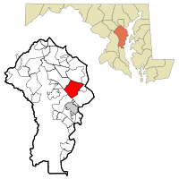
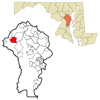
Odenton is a census-designated place (CDP) in Anne Arundel County, Maryland, United States, located approximately 10–20 minutes from the state capital, Annapolis. The population was 37,132 at the 2010 census, up from 20,534 at the 2000 census. The town's population growth rate of 80.8% between 2000 and 2010 was the greatest of any town in western Anne Arundel County. Odenton is located west of Annapolis, south of Baltimore, and northeast of Washington.

<span class="mw-page-title-main">Parole, Maryland</span> Census-designated place in Maryland, United States

Parole, a suburb of Annapolis, is a census-designated place (CDP) in Anne Arundel County, Maryland, United States. The population was 15,922 at the 2010 census. It has several major roads intersect at the western edge of the state capital, Annapolis, and it contains the Annapolis Mall, a number of other large shopping centers, and the Anne Arundel Medical Center. It is generally considered to be part of Annapolis, rather than a separate town. The neighborhood was named because it was a parole camp, where Union and Confederate prisoners of war were brought for mutual exchange and eventual return to their respective homes.

<span class="mw-page-title-main">Pasadena, Maryland</span> Census-designated place in Maryland, United States

Pasadena is a census-designated place (CDP) in Anne Arundel County, Maryland, United States. The population was 24,287 at the 2010 census.

<span class="mw-page-title-main">Severn, Maryland</span> Census-designated place in Maryland, United States

Severn is a census-designated place (CDP) in Anne Arundel County, Maryland, United States. According to the 2020 U.S. census, the population of Severn is 57,118, a 22.6% increase from 44,231 in 2010. The zip code is 21144.

<span class="mw-page-title-main">Severna Park, Maryland</span> Census-designated place in Maryland, United States

Severna Park is a census-designated place (CDP) in Anne Arundel County, Maryland, United States. Severna Park is part of the Baltimore-Washington Metropolitan Area, and is located approximately 8 miles (13 km) north of Annapolis, 17 miles (27 km) south of Baltimore and 39 miles (63 km) east of Washington, D.C. Severna Park's population was 39,933 at the 2020 census.

<span class="mw-page-title-main">Severn River (Maryland)</span> River in Maryland, United States

The Severn River is a tidal estuary 14 miles (23 km) long, located in Anne Arundel County in the U.S. state of Maryland, south of the Magothy River and north of the South River.

<span class="mw-page-title-main">Maryland Route 648</span> Highway in Maryland

Maryland Route 648 is a collection of state highways in the U.S. state of Maryland. These nine highways are current or former sections of the Baltimore–Annapolis Boulevard between Annapolis and Baltimore via Glen Burnie. There are five signed mainline segments of MD 648 through Arnold, Severna Park, Pasadena, Glen Burnie, Ferndale, and Pumphrey in northern Anne Arundel County; Baltimore Highlands in southern Baltimore County; and the independent city of Baltimore. MD 648 mainly serves local traffic along its meandering route, with long-distance traffic intended to use the parallel and straighter MD 2 south of Glen Burnie and freeway-grade Interstate 97 (I-97), I-695, and MD 295 between Glen Burnie and Baltimore.

<span class="mw-page-title-main">Hanover, Maryland</span> Unincorporated community in Maryland, United States

Hanover is an unincorporated community in the Baltimore/Annapolis area in northwestern Anne Arundel County and eastern Howard County in the U.S. state of Maryland, located south of Baltimore.

<span class="mw-page-title-main">Severna Park High School</span> Public school in Severna Park, Maryland, United States

Severna Park High School is a public high school in the United States located in the suburban CDP of Severna Park, Maryland. It is a part of the Anne Arundel County Public Schools system. SPHS opened its doors to students in 1959 and was the seventh public high school opened in Anne Arundel County.. Its principal is Lindsay Abruzzo. A new school was built on the same grounds, and opened in January 2017. The Falcons are sports rivals with nearby Broadneck High School.

The Magothy River runs 12.1 miles (19.5 km) through Anne Arundel County in the U.S. state of Maryland. It is located south of the Patapsco River and north of the Severn River. There are two public park paddling access points, Beachwood Park on the north shore a half mile east of the Magothy Bridge Road bridge, and Spriggs Farm Park off Bayberry Drive, on the south shore two miles west of the Magothy's mouth. Both are Anne Arundel County parks.

<span class="mw-page-title-main">Anne Arundel County Public Schools</span>

Anne Arundel County Public Schools is the public school district serving Anne Arundel County, Maryland. With over 80,000 students, the AACPS school system is the 4th largest in Maryland and the 39th largest in the United States. The district has over 5,000 teachers supporting a comprehensive curriculum from Pre-K through 12th grade.

<span class="mw-page-title-main">Broadneck High School</span> Public, coeducational school in Annapolis, Maryland, United States

Broadneck High School is a school in the United States, located in Anne Arundel County, Maryland, on Green Holly Drive, on the border between Arnold and Cape St. Claire, suburbs of Annapolis. The Bruin is the school's mascot. Broadneck is part of the Anne Arundel County Public Schools system and known for the breadth of its Advanced Placement program, among its higher-level courses such as Linear Algebra. It has been the test school for courses such as Calculus III and offers options to take classes at the nearby Anne Arundel Community College and CAT-South schools. The current BHS feeder middle schools are Severn River Middle School and Magothy River Middle School.

The Little Magothy River runs 2.5 miles (4.0 km) through Anne Arundel County in the U.S. state of Maryland. It is located southeast of the Magothy River, just outside its mouth and north of the Severn River.

The Broadneck Peninsula is an area in Anne Arundel County, Maryland. The area is north of the Severn River, south of the Magothy River and west of the Chesapeake Bay. At the lower end of the Broadneck Peninsula is the 4.3 mile Chesapeake Bay Bridge.

St. Margaret's is a suburb of Annapolis in Anne Arundel County, Maryland, United States on the scenic Broadneck Peninsula. The ZIP code is 21409.

References

  1. "2020 U.S. Gazetteer Files". United States Census Bureau. Retrieved April 26, 2022.
  2. "Arnold". Geographic Names Information System . United States Geological Survey, United States Department of the Interior . Retrieved August 21, 2023.
  3. "Distance between Arnold, MD and Baltimore, MD".
  4. "Distance between Arnold, MD and Washington, DC".
  5. "Geographic Identifiers: 2010 Demographic Profile Data (G001): Arnold CDP, Maryland". U.S. Census Bureau, American Factfinder. Archived from the original on February 12, 2020. Retrieved May 29, 2013.
  6. "Arnold History Project". Aacps.org. Archived from the original on October 12, 2012. Retrieved September 14, 2012.
  7. "Part I: The Little Post Office That Grew" . Retrieved March 23, 2021.
  8. Crispino, Peter. "Mago Vista Beach Is Arnold's Bygone Tourist Attraction". Severna Park Voice. Retrieved March 23, 2021.
  9. "US Gazetteer files: 2010, 2000, and 1990". United States Census Bureau. February 12, 2011. Retrieved April 23, 2011.
  10. "Census of Population and Housing". Census.gov. Retrieved June 4, 2016.
  11. "U.S. Census website". United States Census Bureau . Retrieved January 31, 2008.
  12. https://www.census.gov/quickfacts/fact/table/arnoldcdpmaryland/PST045219 [ dead link ]
  13. "AACC Ranks as No. 1 Community College, March 10 - Anne Arundel Community College". www.aacc.edu. Retrieved March 28, 2021.
  14. [ dead link ]
  15. Rucker, Colby B. (July 2003). "Tall Trees of Chase Creek Woods". Nativetreesociety.org. Retrieved September 14, 2012.
  16. Miller, Ben. "Keeping the Legacy Alive". Bay Weekly. Vol. 15, no. 2. Archived from the original on January 8, 2009. Retrieved October 9, 2018.
  17. "Diane Black". Archives of Women's Political Communication. Iowa State University. Retrieved October 9, 2018.
  18. Kilgore, Adam (August 1, 2016). "Matthew Centrowitz follows his father's footsteps to a second Olympic team". Washington Post. Retrieved October 9, 2018.