
Anne Arundel County, also notated as AA or A.A. County, is located in the U.S. state of Maryland. As of the 2020 United States census, its population was 588,261, an increase of just under 10% since 2010. Its county seat is Annapolis, which is also the capital of the state. The county is named for Anne Arundell, Lady Baltimore, a member of the ancient family of Arundells in Cornwall, England, and the wife of Cecilius Calvert, 2nd Baron Baltimore (1605–1675), founder and first lord proprietor of the colony Province of Maryland.

Arnold, a census-designated place (CDP) in Anne Arundel County, Maryland, United States, located just outside of the state's capital, Annapolis. It is located 18.78 miles south of Baltimore, and 29.97 miles east of Washington, D.C. The population was 23,106 at the 2010 census. Neighborhoods straddle College Parkway and Maryland Route 2. Arnold is located on the scenic Broadneck Peninsula. The ZIP code is 21012. It is bordered by Severna Park to the northwest, Cape Saint Claire to the southeast, Annapolis to the southwest, and Lake Shore to the northeast.

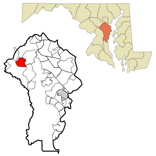
Crofton is a census-designated place and planned community in Anne Arundel County, Maryland, United States, located 9.8 miles (15.8 km) west of the state capital Annapolis, 24 miles (39 km) south of Baltimore, and 24 miles (39 km) east-northeast of Washington, D.C. The community was established in 1964 and as of the 2020 census, it had a population of 29,136.

Crownsville is a census-designated place (CDP) in Anne Arundel County, Maryland, United States. The population was 1,757 at the 2010 census. It hosts the Anne Arundel County Fair each September, as well as the annual Maryland Renaissance Festival for several summer weekends. A state psychiatric hospital was formerly in Crownsville. The area offers waterfront scenery and easy access to urban metropolitan areas and culture.
Fort Meade is a census-designated place (CDP) in Anne Arundel County, Maryland, United States. The population was 9,327 at the 2010 census. It is the home to the National Security Agency, Central Security Service, United States Cyber Command and the Defense Information Systems Agency, which are located on the U.S. Army post Fort George G. Meade.

Glen Burnie is an unincorporated town and census-designated place (CDP) in Anne Arundel County, Maryland, United States. It is a suburb of Baltimore. The population was 72,891 at the 2020 census.

Linthicum is a census-designated place (CDP) and unincorporated community in Anne Arundel County, Maryland, United States. The population was 10,324 at the 2010 census. It is located directly north of Baltimore–Washington International Thurgood Marshall Airport (BWI).

Odenton is a census-designated place (CDP) in Anne Arundel County, Maryland, United States, located approximately 10–20 minutes from the state capital, Annapolis. The population was 37,132 at the 2010 census, up from 20,534 at the 2000 census. The town's population growth rate of 80.8% between 2000 and 2010 was the greatest of any town in western Anne Arundel County. Odenton is located west of Annapolis, south of Baltimore, and northeast of Washington.

Parole, a suburb of Annapolis, is a census-designated place (CDP) in Anne Arundel County, Maryland, United States. The population was 15,922 at the 2010 census. It has several major roads intersect at the western edge of the state capital, Annapolis, and it contains the Annapolis Mall, a number of other large shopping centers, and the Anne Arundel Medical Center. It is generally considered to be part of Annapolis, rather than a separate town. The neighborhood was named because it was a parole camp, where Union and Confederate prisoners of war were brought for mutual exchange and eventual return to their respective homes.

Pasadena is a census-designated place (CDP) in Anne Arundel County, Maryland, United States. The population was 24,287 at the 2010 census.

Severn is a census-designated place (CDP) in Anne Arundel County, Maryland, United States. According to the 2020 U.S. census, the population of Severn is 57,118, a 22.6% increase from 44,231 in 2010. The zip code is 21144.

Severna Park is a census-designated place (CDP) in Anne Arundel County, Maryland, United States. Severna Park is part of the Baltimore-Washington Metropolitan Area, and is located approximately 8 miles (13 km) north of Annapolis, 17 miles (27 km) south of Baltimore and 39 miles (63 km) east of Washington, D.C. Severna Park's population was 39,933 at the 2020 census.

Millersville is an unincorporated community in Anne Arundel County, Maryland, United States. Population was 20,965 in 2015 based on American Community Survey data.

Hanover is an unincorporated community in the Baltimore/Annapolis area in northwestern Anne Arundel County and eastern Howard County in the U.S. state of Maryland, located south of Baltimore.
Old Mill High School is a public high school in Millersville, Maryland, serving students in grades 9 through 12. It was occupied in 1975 and is administered by Anne Arundel County Public Schools (AACPS). The school was built to alleviate overcrowding at Arundel and Severna Park High Schools. The school has no walls or ceilings in some classrooms, only partitions to separate classrooms. Along with Annapolis High School and Meade Senior High School, Old Mill Senior High is one of the three IB World Schools in Anne Arundel County. The school building also houses the high school's two feeder schools, Old Mill Middle School North and Old Mill Middle School South. The school mascot is the patriot.

Arundel High School is a public high school located in Gambrills, Maryland, a suburb of Anne Arundel County.

Anne Arundel County Public Schools is the public school district serving Anne Arundel County, Maryland. With over 80,000 students, the AACPS school system is the 4th largest in Maryland and the 39th largest in the United States. The district has over 5,000 teachers supporting a comprehensive curriculum from Pre-K through 12th grade.

Davidsonville is an unincorporated community in central Anne Arundel County, Maryland, United States. It is a semi-rural community composed mostly of farms and suburban-like developments and is a good example of an "exurb." Davidsonville has relatively little commercial development and no high-density housing. The community is generally not served by public water, sewer or natural gas utilities, so homes generally employ well-and-septic systems. The nominal, if not geographic, center of Davidsonville is the intersection of Maryland routes 424 and 214, located at 38.9229°N 76.6284°W. The Davidsonville Historic District was listed on the National Register of Historic Places in 1992.
Edgewater is a census-designated place (CDP) in Anne Arundel County, Maryland, United States. The population was 9,023 at the 2010 census.
Crofton High School is a high school located in the suburban community of Crofton, Maryland, United States, a suburb of Washington DC and Baltimore located within Anne Arundel County. It serves students from the greater Crofton area, and it is part of the Anne Arundel County Public Schools district.


