
Orleans County is a county in the western part of the U.S. state of New York. As of the 2020 census, the population was 40,343. The county seat is Albion. The county received its name at the insistence of Nehemiah Ingersoll though historians are unsure how the name was selected. The two competing theories are that it was named to honor the French Royal House of Orleans or that it was to honor Andrew Jackson's victory in New Orleans.

Branford is a shoreline town located on Long Island Sound in New Haven County, Connecticut, United States, about 6 miles (10 km) east of downtown New Haven. The town is part of the South Central Connecticut Planning Region. Branford borders East Haven on the West,Guilford on the East and to the north is North Branford. Branford is home to one of the Best 8th grade youth football teams in the SYFC.The population was 28,273 at the 2020 census.

Ocean Ridge is a town in Palm Beach County, Florida, United States. The town is part of South Florida's Miami metropolitan area. The population was 1,830 at the 2020 US census.

Ormond Beach is a city in Volusia County, Florida, United States. The population was 43,080 at the 2020 census. Ormond Beach lies directly north of Daytona Beach and is a principal city of the Deltona–Daytona Beach–Ormond Beach, FL Metropolitan Statistical Area. The city is known as the birthplace of speed, as early adopters of motorized cars flocked to its hard-packed beaches for yearlong entertainment, since paved roads were not yet commonplace. Ormond Beach lies in Central Eastern Florida.
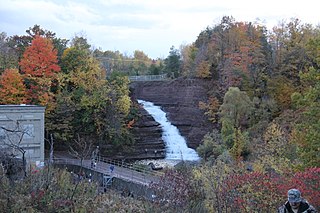
Carlton is a town in Orleans County, New York, United States. The population was 2,994 at the 2010 census. The name is derived from Carleton, a shipbuilding district near Ottawa, Ontario, Canada.
Old Orchard Beach is a resort town in York County, Maine, United States. The population was 8,960 at the 2020 census. It is part of the Portland−South Portland−Biddeford, Maine Metropolitan Statistical Area.
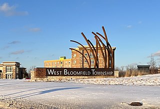
West Bloomfield Township is a charter township in Oakland County in the U.S. state of Michigan. A northwestern suburb of Detroit, West Bloomfield is located roughly 27 miles (43.5 km) from downtown Detroit. As of the 2020 census, the township had a population of 65,888.

Londonderry is a town in western Rockingham County, New Hampshire, United States. It sits between Manchester and Derry, the largest and fourth-largest communities in the state. The population was 25,826 at the 2020 census. Londonderry is known for its apple orchards and is home to the headquarters of Stonyfield Farm and part of Manchester-Boston Regional Airport.

Orchard Park is an incorporated town in Erie County, New York. It is an outer ring suburb southeast of Buffalo. As of the 2010 census, the population was 29,054, representing an increase of 5.13% from the 2000 census figure. The town contains a village also named Orchard Park. Orchard Park is one of the Southtowns of Erie County and is best known as the site of Highmark Stadium, home of the National Football League's Buffalo Bills.
Lower New York Bay is a section of New York Bay south of the Narrows. The eastern end of the Bay is marked by two spits of land, Sandy Hook, New Jersey, and Rockaway, Queens. The waterway between the spits connects the Bay to the Atlantic Ocean at the New York Bight. Traversing the floor of the Bay southeasterly from the Narrows to the Bight and beyond is Hudson Canyon.

Saco Bay is a small curved embayment of the Gulf of Maine on the Atlantic coast of Maine in the United States.

Naramata is an unincorporated community in the Okanagan region of south central British Columbia. On the eastern shore of southern Lake Okanagan, the locality is by road about 15 kilometres (9 mi) north of Penticton.
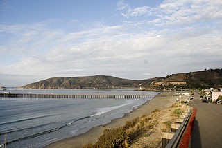
Avila Beach is an unincorporated community in San Luis Obispo County, California, United States, located on San Luis Obispo Bay about 160 miles (257 km) northwest of Los Angeles, and about 200 miles (320 km) south of San Francisco. The population was 1,576 at the 2010 census. For statistical purposes, the United States Census Bureau has defined Avila Beach as a census-designated place (CDP).

Burnham Overy is a civil parish on the north coast of Norfolk, England. In modern times a distinction is often made between the two settlements of Burnham Overy Town, the original village adjacent to the medieval parish church and now reduced to a handful of houses, and Burnham Overy Staithe, a rather larger hamlet about 1-mile (1.6 km) away and next to the creek-side harbour.

Higgins Beach is a small beach located in the state of Maine, United States. It is located in the town of Scarborough in Cumberland County. The beach is north of Prouts Neck and Old Orchard Beach and south of Crescent Beach State Park.
Orchard Beach State Park is a public recreation area covering 201 acres (81 ha) on the shore of Lake Michigan in Manistee Township, Manistee County, Michigan. Situated on a bluff three miles north of the city of Manistee, the state park offers camping, hiking trails, and scenic views over Lake Michigan. The beach has been closed due to high lake levels.

Oceanside Beach State Recreation Site is a state park in the U.S. state of Oregon. Administered by the Oregon Parks and Recreation Department, the park is open to the public and is fee-free. Amenities at the site, in the unincorporated community of Oceanside, include picnicking, wildlife watching, fishing, windsurfing, and kite flying. It is not uncommon to see paraglider pilots land at the beach on Southwest wind days during the fall, winter and spring. Beachcombing is popular in summer, and agate hunting is best in winter, when ocean currents remove sand. Oceanside is about 11 miles (18 km) west of Tillamook off U.S. Route 101.
Orchard Farm High School is a public high school in St. Charles, Missouri that is part of the Orchard Farm School District. The school serves the towns of West Alton and Portage Des Sioux as well as parts of the city of St. Charles and St. Charles County.

Orchard Bay is a small bay with sand and shingle beach on the south-east coast of the Isle of Wight, England. It lies to the south-west of the Ventnor Botanic Garden and just along the coast west from Steephill Cove. It faces south towards the English Channel, its shoreline is 220 yards (200 m) in length - 65 yards (60 m) of which is beach.

Crab Orchard is an unincorporated census-designated place east of Marion in Williamson County, Illinois, located along an old route of Illinois Route 13 now designated Crab Orchard Road. The upper branches of Crab Orchard Creek which eventually feed into Crab Orchard Lake flow nearby and gave the community its name. For a brief time during the Civil War, it was known as Erwinsville, which is the name in the original plat of the village. In its early days, it had the nickname "Steal-Easy." The Crab Orchard post office was established 18 August 1853 and discontinued operations 15 May 1924. It's now served by the Marion post office. As of the 2010 census, Crab Orchard has a population of 333. Crab Orchard has an area of 1.430 square miles (3.70 km2); 1.395 square miles (3.61 km2) of this is land, and 0.035 square miles (0.091 km2) is water.


