
Denton is a town in Caroline County, Maryland, United States. The population of Denton was 4,418 as of the 2010 United States Census, and it is the county seat of Caroline County.
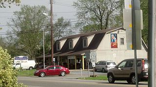
Harmony is an unincorporated community in Caroline County, Maryland, United States. It is little more than an intersection of state Routes 16 and 578 on Maryland's Eastern Shore. Its original name was Fowling Creek, named after a stream nearby that is a tributary of the Choptank River.
Lanham is an unincorporated community and census-designated place in Prince George's County, Maryland. As of the 2020 United States Census it had a population of 11,282. The New Carrollton station as well as an Amtrak station are across the Capital Beltway in New Carrollton, Maryland. Doctors Community Hospital is located in Lanham.
American Corner is a populated place in Caroline County, Maryland, United States. American Corner is home to Colonel Richardson High School and Colonel Richardson Middle School. On older maps, it is sometimes referred to as American Corners. There was formerly a post office, cannery, blacksmith, and a store located there, as seen on the 1875 and 1897 Maps of Caroline County, Maryland.
Intermont is an unincorporated community in Hampshire County, West Virginia, United States, located along West Virginia Route 259 on the Cacapon River. It was originally known as Mutton Run until 1920, when its name was changed to Intermont. Because of Mutton Run's location on the Winchester and Western Railroad, it may have been renamed after the Intermountain Construction Company that completed the railroad from Winchester to Wardensville. Their post office is closed.

The Chippewa River is a stream in Michigan, United States, that runs 91.8 miles (147.7 km) through the central Lower Peninsula. The Chippewa is a tributary of the Tittabawassee River and is thus part of the Saginaw River drainage basin. The river is named after the Chippewa people.

Winchester National Cemetery is a United States National Cemetery located in the city of Winchester in Frederick County, Virginia. Administered by the United States Department of Veterans Affairs, it encompasses 4.9 acres (2.0 ha), and as of the end of 2005, it had 5,561 interments. It is closed to new interments.
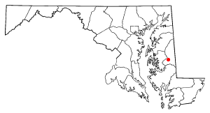
Andersontown is a populated place on Maryland's Eastern Shore in Caroline County, Maryland, United States. It is situated near the Delaware line, centered on the intersection of Andersontown Road and Maryland Route 404.
Gilpin Point is a cape on Maryland's Eastern Shore in Caroline County, Maryland, United States. It was the home of Revolutionary War soldier William Richardson, who distinguished himself in the Battle of Harlem Heights. There is a tomb dedicated to him next to Gilpin's Point Landing Park. It was placed by the Caroline County Historical Society in the 1950s.
Nanjemoy Creek is a 13.1-mile-long (21.1 km) tidal tributary of the Potomac River in Charles County, Maryland, United States, located between Cedar Point Neck and Tayloe's Neck. Its watershed area is 73 square miles (190 km2), with 2% impervious surface in 1994.
The Little Magothy River runs 2.5 miles (4.0 km) through Anne Arundel County in the U.S. state of Maryland. It is located southeast of the Magothy River, just outside its mouth and north of the Severn River.

Jonas Green Park is a public recreation area on the Severn River owned and operated by Anne Arundel County, Maryland. The park sits at the east end of the Naval Academy Bridge on Maryland Route 450 just outside the city of Annapolis. The former state park bears the name of Jonas Green, Maryland’s public printer during the colonial period. It was turned over to the county in 2009. The park offers a visitors center, cartop boat launch site, and fishing pier. It is the southern terminus of the Baltimore & Annapolis Trail.
Bethlehem is a populated place in Caroline County, Maryland, United States. Bethlehem is located at the intersection of Maryland routes 331 and 578, northwest of Preston.
Burrsville is a populated place in Caroline County, Maryland, United States. One of the first references is on the 1875 Map of Caroline County, where the Burrsville Post Office appears. Burrsville is located near the Delaware border.
Reliance is an unincorporated community located on the border of the U.S. states of Maryland and Delaware. The Maryland side of the community has portions in Caroline and Dorchester counties, while the Delaware side is located within Sussex County. Reliance is along Delaware Route 20 and Maryland Route 392 at the junction with Maryland Route 577, west of Seaford. It was previously known as Johnson's Crossroads.
Severn is an unincorporated community in Gloucester County, Virginia, United States. Severn is 5.5 miles (8.9 km) northeast of Gloucester Point. Severn has a post office with ZIP code 23155.
Winchester is an unincorporated community in Bloomfield Township, Jackson County, Ohio, United States. It is located southeast of Jackson along U.S. Route 35, next to Rocky Hill, at the intersection of Dixon Run Road and Winchester-Vega Road, at 38°59′13″N82°32′21″W.
Rocky Hill is an unincorporated community in Bloomfield Township, Jackson County, Ohio, United States. It is located southeast of Jackson along U.S. Route 35, next to Winchester at the intersection of C H & D Road and Dixon Run Road, at 38°59′20″N82°32′42″W.


