
Anne Arundel County, also notated as AA or A.A. County, is located in the U.S. state of Maryland. As of the 2020 United States census, its population was 588,261, an increase of just under 10% since 2010. Its county seat is Annapolis, which is also the capital of the state. The county is named for Lady Anne Arundell, a member of the ancient family of Arundells in Cornwall, England, and the wife of Cecilius Calvert, 2nd Baron Baltimore (1605–1675), founder and first lord proprietor of the colony Province of Maryland.

Brooklyn Park is a census-designated place (CDP) in Anne Arundel County, Maryland, United States. The population was 14,373 at the 2010 census.
Fort Meade is a census-designated place (CDP) in Anne Arundel County, Maryland, United States. The population was 9,327 at the 2010 census. It is the home to the National Security Agency, Central Security Service, United States Cyber Command and the Defense Information Systems Agency, which are located on the U.S. Army post Fort George G. Meade.

Parole, a suburb of Annapolis, is a census-designated place (CDP) in Anne Arundel County, Maryland, United States. The population was 15,922 at the 2010 census. It is where several major roads intersect at the western edge of the state capital, Annapolis, and contains the Annapolis Mall, and a number of other large shopping centers, and the Anne Arundel Medical Center. It is generally considered to be part of Annapolis rather than a separate town. The neighborhood was named because it was a parole camp, where Union and Confederate prisoners of war were brought for mutual exchange and eventual return to their respective homes.

Pasadena is a census-designated place (CDP) in Anne Arundel County, Maryland, United States. The population was 24,287 at the 2010 census.

Shady Side is a census-designated place (CDP) in Anne Arundel County, Maryland, United States. The population was 5,803 at the 2010 census.

The Severn River is a tidal estuary 14 miles (23 km) long, located in Anne Arundel County in the U.S. state of Maryland, south of the Magothy River and north of the South River.

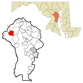
Millersville is an unincorporated community in Anne Arundel County, Maryland, United States. Population was 20,965 in 2015 based on American Community Survey data.

WRNR-FM is a commercial radio station licensed to Grasonville, Maryland, broadcasting mainly to the Annapolis / Anne Arundel County area and the Eastern Shore of Maryland on 103.1 FM. WRNR-FM airs an adult album alternative music format.
The South River is a 10-mile-long (16 km) tributary of the Chesapeake Bay in Anne Arundel County, Maryland in the United States. It lies south of the Severn River, east of the Patuxent River, and north of the West River and Rhode River, and drains to the Chesapeake Bay.

Davidsonville is an unincorporated community in central Anne Arundel County, Maryland, United States. It is a semi-rural community composed mostly of farms and suburban-like developments and is a good example of an "exurb." Davidsonville has relatively little commercial development and no high-density housing. The community is generally not served by public water, sewer or natural gas utilities, so homes generally employ well-and-septic systems. The nominal, if not geographic, center of Davidsonville is the intersection of Maryland routes 424 and 214, located at 38.9229°N 76.6284°W. The Davidsonville Historic District was listed on the National Register of Historic Places in 1992.
The Rhode River is a 3-mile-long (5 km) tidal tributary of the West River in Anne Arundel County, Maryland. It is south of the South River.
Lyons Creek is an 11.2-mile-long (18.0 km) tributary of the Patuxent River in Maryland. Lyons Creek serves as the border between southern Anne Arundel County, Maryland and northern Calvert County, Maryland.

Curtis Creek is a tidal creek located in Baltimore City and Anne Arundel County, Maryland. It is a tributary of the cove Curtis Bay and is adjacent to the west of the South Baltimore community of Curtis Bay. The creek begins at the confluence of Furnace Creek and Marley Creek in northern Anne Arundel County, Maryland and flows north about 2.5 miles (4.0 km) into Curtis Bay which opens to the east into the main branch and stem of the Patapsco River and Chesapeake Bay.

Brooklyn is one of the southernmost neighborhoods in Baltimore, Maryland. It is located near Anne Arundel County along Governor Ritchie Highway which is also Maryland Route 2. Its main roads are South Hanover Street,, Potee Street, and East Patapsco Avenue, Sixth Street, Tenth Street, and West Bay Avenue which borders the neighboring Curtis Bay community to the east, running through Bay Brook Park, which separates the two. South Hanover Street also serves as the dividing line between east–west streets in Brooklyn, as Charles Street does not exist here. Often mistaken as Brooklyn Park, Brooklyn shares the 21225 ZIP Code with the greater Brooklyn Park area which is across the Baltimore City Line in and the other neighboring community of Cherry Hill to the west and northwest across the now small western branch of the Patapsco River flowing from Ellicott City and Elkridge and along the shoreline-hugging southern extension "South Hanover Street" of the downtown's old colonial-era "Hanover Street" across the 1914-1917 Hanover Street Bridge, later renamed the Vietnam Veterans Memorial Bridge in the 1990s.
The Little Magothy River runs 2.5 miles (4.0 km) through Anne Arundel County in the U.S. state of Maryland. It is located southeast of the Magothy River, just outside its mouth and north of the Severn River.
The West River is a 6-mile-long (9.7 km) tidal tributary of Chesapeake Bay in southern Anne Arundel County, Maryland. It is south of the Rhode River, which is one of its tributaries, and north of Herring Bay.
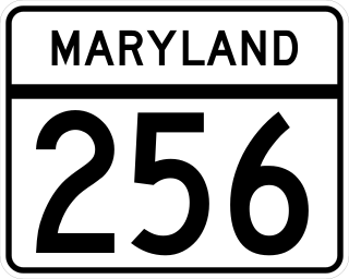
Maryland Route 256 is a state highway in the U.S. state of Maryland. The highway runs 5.28 miles (8.50 km) from MD 2 at Tracys Landing east to MD 468 in Shady Side. MD 256 connects the aforementioned communities with Deale on the shore of Herring Bay in southern Anne Arundel County. The highway was constructed at either end in the mid-1920s and completed through Deale in the early 1930s.
Chestnut Hill Cove is an unincorporated community in Anne Arundel County, Maryland, United States.

Guilford Road is a historic road north of Savage, Maryland that traverses Anne Arundel and Howard Counties in an area that was first settled by English colonists in the mid-1600s. Today's Guilford road is a series of disconnected segments bisected multiple times by the construction of Maryland Route 32.

