Howard County is located in the U.S. state of Maryland. As of the 2020 census, the population was 334,529. Since there are no incorporated municipalities, there is no incorporated county seat either. Therefore, its county seat is the unincorporated community of Ellicott City. Howard County is included in the Baltimore-Columbia-Towson, MD Metropolitan Statistical Area, which is part of the larger Washington–Baltimore combined statistical area.

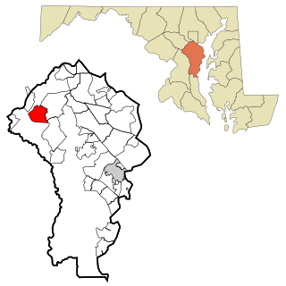
Anne Arundel County, also notated as AA or A.A. County, is located in the U.S. state of Maryland. As of the 2020 United States census, its population was 588,261, an increase of just under 10% since 2010. Its county seat is Annapolis, which is also the capital of the state. The county is named for Anne Arundell, Lady Baltimore, a member of the ancient family of Arundells in Cornwall, England, and the wife of Cecilius Calvert, 2nd Baron Baltimore (1605–1675), founder and first lord proprietor of the colony Province of Maryland.

Arnold, a census-designated place (CDP) in Anne Arundel County, Maryland, United States, located just outside of the state's capital, Annapolis. It is located 18.78 miles south of Baltimore, and 29.97 miles east of Washington, D.C. The population was 23,106 at the 2010 census. Neighborhoods straddle College Parkway and Maryland Route 2. Arnold is located on the scenic Broadneck Peninsula. The ZIP code is 21012. It is bordered by Severna Park to the northwest, Cape Saint Claire to the southeast, Annapolis to the southwest, and Lake Shore to the northeast.

Brooklyn Park is a census-designated place (CDP) in Anne Arundel County, Maryland, United States. The population was 14,373 at the 2010 census.

Crofton is a census-designated place and planned community in Anne Arundel County, Maryland, United States, located 9.8 miles (15.8 km) west of the state capital Annapolis, 24 miles (39 km) south of Baltimore, and 24 miles (39 km) east-northeast of Washington, D.C. The community was established in 1964 and as of the 2020 census, it had a population of 29,136.

Crownsville is a census-designated place (CDP) in Anne Arundel County, Maryland, United States. The population was 1,757 at the 2010 census. It hosts the Anne Arundel County Fair each September, as well as the annual Maryland Renaissance Festival for several summer weekends. A state psychiatric hospital was formerly in Crownsville. The area offers waterfront scenery and easy access to urban metropolitan areas and culture.

Ferndale is a census-designated place (CDP) in Anne Arundel County, Maryland, United States. At the 2010 census, the population was 16,746.
Fort Meade is a census-designated place (CDP) in Anne Arundel County, Maryland, United States. The population was 9,327 at the 2010 census. It is the home to the National Security Agency, Central Security Service, United States Cyber Command and the Defense Information Systems Agency, which are located on the U.S. Army post Fort George G. Meade.

Linthicum is a census-designated place (CDP) and unincorporated community in Anne Arundel County, Maryland, United States. The population was 10,324 at the 2010 census. It is located directly north of Baltimore–Washington International Thurgood Marshall Airport (BWI).

Maryland City is a census-designated place (CDP) in Anne Arundel County, Maryland, United States. The population was 16,093 at the 2010 census. It is located east of Laurel, just over the border with Prince George's County, and it has a Laurel ZIP Code. Maryland City mostly consists of an older, compact housing development and is adjacent to Fort Meade army base. A large newer development on the north side of Maryland Route 198 is known as Russett and is included within the Maryland City CDP.

Odenton is a census-designated place (CDP) in Anne Arundel County, Maryland, United States, located approximately 10–20 minutes from the state capital, Annapolis. The population was 37,132 at the 2010 census, up from 20,534 at the 2000 census. The town's population growth rate of 80.8% between 2000 and 2010 was the greatest of any town in western Anne Arundel County. Odenton is located west of Annapolis, south of Baltimore, and northeast of Washington.

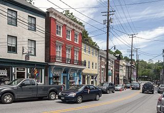
Parole, a suburb of Annapolis, is a census-designated place (CDP) in Anne Arundel County, Maryland, United States. The population was 15,922 at the 2010 census. It has several major roads intersect at the western edge of the state capital, Annapolis, and it contains the Annapolis Mall, a number of other large shopping centers, and the Anne Arundel Medical Center. It is generally considered to be part of Annapolis, rather than a separate town. The neighborhood was named because it was a parole camp, where Union and Confederate prisoners of war were brought for mutual exchange and eventual return to their respective homes.

Pasadena is a census-designated place (CDP) in Anne Arundel County, Maryland, United States. The population was 24,287 at the 2010 census.

Severn is a census-designated place (CDP) in Anne Arundel County, Maryland, United States. According to the 2020 U.S. census, the population of Severn is 57,118, a 22.6% increase from 44,231 in 2010. The zip code is 21144.

Shady Side is a census-designated place (CDP) in Anne Arundel County, Maryland, United States. The population was 5,803 at the 2010 census.

Owings is a town center and census-designated place (CDP) in northern Calvert County, Maryland, United States. The population was 2,149 at the 2010 census, up from 1,325 in 2000.

Baltimore Highlands is a census-designated place (CDP) in Baltimore County, Maryland, United States, directly south of the city of Baltimore. The population was 7,019 at the 2010 census. At the 2000 census and earlier, the area was delineated as part of the Lansdowne-Baltimore Highlands CDP.
Gambrills refers to two neighboring places in Anne Arundel County, Maryland, United States, located in the Annapolis metro area: the unincorporated community of Gambrills, and the Gambrills census-designated place (CDP). The area was named after Augustine Gambrill, plantation owner. The CDP covers an expansive range that falls within the communities of Crofton, Waugh Chapel, and Odenton. It also borders Davidsonville, Crownsville, Millersville, and Prince George's County, Maryland. In 2022, the population of the CDP was 2,837. The median-income of residents was $140,238. Gambrills is served by routes 3, 32 and MARC, the Maryland commuter rail service. There is a MARC station in the neighboring town of Odenton.
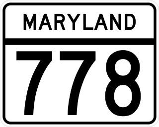
Maryland Route 778 is a state highway in the U.S. state of Maryland. Known as Old Solomons Island Road, the state highway runs 2.12 miles (3.41 km) from MD 2 near Owings north to MD 261 at Friendship. MD 778 and its unsigned auxiliary routes are segments of the old alignment of MD 2 in far northern Calvert County and southern Anne Arundel County. MD 2 was originally constructed as one of the original state roads in the early to mid-1910s. The state highway from Edgewater south to Owings was reconstructed in stages from the early 1950s to the mid-1960s, when the Owings–Friendship portion of MD 2 was relocated. As portions of the old MD 2 were bypassed, they were designated segments of MD 778.


