Naval Academy, Maryland

Last updated

Naval Academy, Maryland
Anne Arundel County Maryland Incorporated and Unincorporated areas Naval Academy Highlighted.svg
Coordinates: 38°58′59″N76°29′23″W / 38.98306°N 76.48972°W / 38.98306; -76.48972
CountryFlag of the United States.svg United States
State Flag of Maryland.svg  Maryland
County Flag of Anne Arundel County, Maryland.png Anne Arundel
Area
[1]
  Total0.86 sq mi (2.22 km2)
  Land0.54 sq mi (1.38 km2)
  Water0.32 sq mi (0.83 km2)
Population
 (2020)
  Total485
  Density906.54/sq mi (350.34/km2)
Time zone UTC−5 (Eastern (EST))
  Summer (DST) UTC−4 (EDT)
ZIP code
21402 (administration & faculty), 21412 (student dormitory)
Area code(s) 410, 443, and 667
FIPS code 24-55050

Naval Academy is a census-designated place (CDP) in Anne Arundel County, Maryland, United States, which covers the campus of the United States Naval Academy. The population was 4,802 at the 2010 census. [2]

Contents

Geography

According to the United States Census Bureau, the CDP has a total area of 0.85 square miles (2.2 km2), of which 0.54 square miles (1.4 km2) is land and 0.31 square miles (0.8 km2), or 36.85%, is water. [2]

Demographics

Historical population
CensusPop.Note
1980 5,367
1990 5,4201.0%
2000 4,264−21.3%
2010 4,80212.6%
2020 485−89.9%
source: [2] [3]

As of the census [4] of 2000, there were 4,264 people, 249 households, and 225 families living in the CDP. The population density was 7,706.5 inhabitants per square mile (2,975.5/km2). There were 263 housing units at an average density of 475.3 per square mile (183.5/km2). The racial makeup of the CDP was 87.10% White, 5.49% African American, 0.33% Native American, 2.95% Asian, 0.12% Pacific Islander, 1.83% from other races, and 2.18% from two or more races. Hispanic or Latino of any race were 6.94% of the population.

There were 249 households, out of which 65.1% had children under the age of 18 living with them, 87.1% were married couples living together, 2.4% had a female householder with no husband present, and 9.6% were non-families. 7.2% of all households were made up of individuals, and 1.2% had someone living alone who was 65 years of age or older. The average household size was 3.37 and the average family size was 3.56.

In the CDP, the population was spread out, with 8.0% under the age of 18, 80.5% from 18 to 24, 8.8% from 25 to 44, 2.4% from 45 to 64, and 0.3% who were 65 years of age or older. The median age was 21 years. For every 100 females, there were 373.3 males. For every 100 females age 18 and over, there were 436.8 males.

The median income for a household in the CDP was $63,333, and the median income for a family was $63,750. Males had a median income of $6,536 versus $6,585 for females. The per capita income for the CDP was $11,491. None of the population or families were below the poverty line.

Related Research Articles

<span class="mw-page-title-main">Moores Mill, Alabama</span> Census-designated place in Alabama, United States

Moores Mill is an unincorporated community and census-designated place (CDP) in Madison County, Alabama, United States, and is included in the Huntsville-Decatur Combined Statistical Area. The population was 6,729 at the 2020 census, up from 5,682 at the 2010 census.

<span class="mw-page-title-main">Central, Alaska</span> CDP in Alaska, United States

Central is a census-designated place (CDP) in Yukon-Koyukuk Census Area, Alaska, United States. At the 2010 census the population was 96, down from 134 in 2000. Every February, Central hosts a checkpoint for the long-distance Yukon Quest sled dog race.

<span class="mw-page-title-main">East Sahuarita, Arizona</span> Community in Pima County, Arizona

East Sahuarita was a census-designated place (CDP) in Pima County, Arizona, United States. The population was 1,419 at the 2000 census. The CDP comprises the unincorporated neighborhoods east of incorporated Sahuarita.

<span class="mw-page-title-main">Summit, Arizona</span> CDP in Pima County, Arizona

Summit is a census-designated place (CDP) in Pima County, Arizona, United States. The population was 3,702 at the 2000 census.

<span class="mw-page-title-main">Mayflower Village, California</span> Census-designated place in California, United States

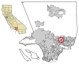
Mayflower Village is a census-designated place (CDP) in the San Gabriel Valley, in Los Angeles County, California, United States. The population was 5,515 at the 2010 census, up from 5,081 at the 2000 census. The ZIP Codes serving the community are 91006, which is served by Arcadia and 91016, which is served by Monrovia.

<span class="mw-page-title-main">Potomac Heights, Maryland</span> Census-designated place in Maryland, United States

Potomac Heights is a census-designated place (CDP) in Charles County, Maryland, United States. The population was 1,117 at the 2010 census. It has a volunteer fire department and numerous older rambler homes built for workers at the nearby U.S. Navy munitions plant in Indian Head.

<span class="mw-page-title-main">Harvey, Michigan</span> Census-designated place & unincorporated community in Michigan, United States

Harvey is a census-designated place (CDP) in Marquette County in the U.S. state of Michigan. The population was 3,244 as of the 2020 census, up from 1,393 in 2010, before the CDP was enlarged by the Census Bureau. The CDP is located within Chocolay and Sands townships.

<span class="mw-page-title-main">Greentree, New Jersey</span> Populated place in Camden County, New Jersey, US

Greentree is an unincorporated community and census-designated place (CDP) located within Cherry Hill Township, in Camden County, in the U.S. state of New Jersey. As of the 2010 United States Census, the CDP's population was 11,367.

<span class="mw-page-title-main">Cherry Grove, Ohio</span> Census-designated place in Ohio, United States

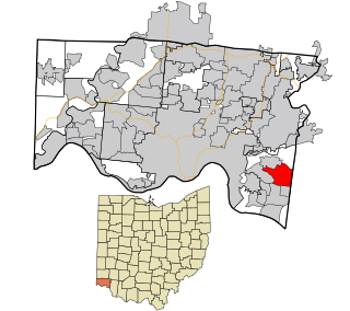
Cherry Grove is a census-designated place (CDP) in Anderson Township, Hamilton County, Ohio, United States. The population was 4,419 at the 2020 census.

<span class="mw-page-title-main">Dry Run, Ohio</span> Census-designated place in Ohio, United States

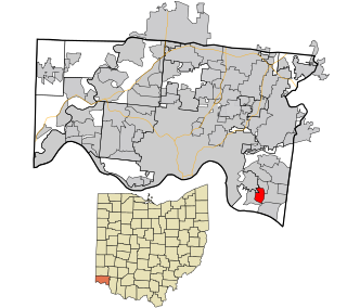
Dry Run is a census-designated place (CDP) in Hamilton County, Ohio, United States. The population was 7,672 at the 2020 census.

<span class="mw-page-title-main">Forestville, Ohio</span> Census-designated place in Ohio, United States

Forestville is a census-designated place (CDP) in Hamilton County, Ohio, United States. The population was 10,615 at the 2020 census.

<span class="mw-page-title-main">Fruit Hill, Ohio</span> Census-designated place in Ohio, United States

Fruit Hill is a census-designated place (CDP) in Hamilton County, Ohio, United States. The population was 3,748 at the 2020 census.

<span class="mw-page-title-main">Turpin Hills, Ohio</span> Census-designated place in Ohio, United States

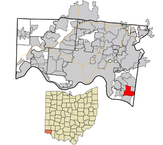
Turpin Hills is a census-designated place (CDP) in Anderson Township, Hamilton County, Ohio, United States. The population was 5,162 at the 2020 census.

<span class="mw-page-title-main">Choctaw Lake, Ohio</span> CDP in Ohio, United States

Choctaw Lake is a census-designated place (CDP) in Madison County, Ohio, United States. The population was 2,047 at the 2020 census.

<span class="mw-page-title-main">Franklin Furnace, Ohio</span> Census-designated place in Ohio, United States

Franklin Furnace is a census-designated place (CDP) in Scioto County, Ohio, United States, along the Ohio River. The population was 1,525 at the 2020 census.

<span class="mw-page-title-main">Spring Mills, Pennsylvania</span> Census designated place in Pennsylvania, United States

Spring Mills is an unincorporated community and census-designated place (CDP) in Centre County, Pennsylvania, United States. It is part of the State College, Pennsylvania Metropolitan Statistical Area. The population was 268 at the 2010 census.

<span class="mw-page-title-main">Socastee, South Carolina</span> CDP in South Carolina, United States

Socastee is a census-designated place (CDP) in Horry County, South Carolina, United States. The population was 19,952 at the 2010 census.

<span class="mw-page-title-main">Green Valley, South Dakota</span> CDP in South Dakota, United States

Green Valley is a census-designated place (CDP) and unincorporated community in Pennington County, South Dakota, United States. The population was 1,051 at the 2020 census.

<span class="mw-page-title-main">Verlot, Washington</span> CDP in Washington, United States

Verlot is a census-designated place (CDP) in Snohomish County, Washington, United States. The population was 285 at the 2010 census.

<span class="mw-page-title-main">Clearbrook, New Jersey</span> Populated place in Middlesex County, New Jersey, US

Clearbrook is a gated community and census-designated place (CDP) located in Monroe Township, Middlesex County, in the U.S. state of New Jersey. It is in the western part of the township, bordered to the north by Encore at Monroe and to the east by Concordia and The Ponds. It is 3.5 miles (5.6 km) southwest of Jamesburg and 5 miles (8 km) northeast of Hightstown.

References

  1. "2020 U.S. Gazetteer Files". United States Census Bureau. Retrieved April 26, 2022.
  2. 1 2 3 "Geographic Identifiers: 2010 Demographic Profile Data (G001): Naval Academy CDP, Maryland". U.S. Census Bureau, American Factfinder. Archived from the original on February 12, 2020. Retrieved June 3, 2013.
  3. "CENSUS OF POPULATION AND HOUSING (1790-2000)". U.S. Census Bureau . Retrieved July 17, 2010.
  4. "U.S. Census website". United States Census Bureau . Retrieved January 31, 2008.