Crownsville, Maryland

Last updated
Crownsville, Maryland
Anne Arundel County Maryland Incorporated and Unincorporated areas Crownsville Highlighted.svg
Location of Crownsville, Maryland,
Coordinates: 39°1′27″N76°35′54″W / 39.02417°N 76.59833°W / 39.02417; -76.59833 Coordinates: 39°1′27″N76°35′54″W / 39.02417°N 76.59833°W / 39.02417; -76.59833
CountryFlag of the United States.svg United States
State Flag of Maryland.svg  Maryland
County Flag of Anne Arundel County, Maryland.png Anne Arundel
Area
[1]
  Total5.09 sq mi (13.19 km2)
  Land5.09 sq mi (13.19 km2)
  Water0.00 sq mi (0.00 km2)
Elevation
121 ft (37 m)
Population
 (2020)
  Total1,924
  Density377.92/sq mi (145.91/km2)
Time zone UTC−5 (Eastern (EST))
  Summer (DST) UTC−4 (EDT)
ZIP code
21032
Area code 410
FIPS code 24-21075
GNIS feature ID0590052

Crownsville is a census-designated place (CDP) in Anne Arundel County, Maryland, United States. The population was 1,757 at the 2010 census. [2] It hosts the Anne Arundel County Fair each September, as well as the annual Maryland Renaissance Festival for several summer weekends. A state psychiatric hospital was formerly in Crownsville. The area offers waterfront scenery and easy access to urban metropolitan areas and culture.

Contents

Geography

Crownsville is located at 39°1′27″N76°35′54″W / 39.02417°N 76.59833°W / 39.02417; -76.59833 (39.024149, 76.598295), [3] 7 miles (11 km) northwest of Annapolis, the state capital. Maryland Route 178 (Generals Highway) runs through the center of the CDP, and Interstate 97 forms the southwestern edge of the CDP, with access from the north via Exit 5.

According to the United States Census Bureau, the CDP has a total area of 5.1 square miles (13.2 km2), all land. [2] However, waterfront communities such as Arden On The Severn and Herald Harbor have Crownsville addresses.

Demographics

Historical population
CensusPop.
2020 1,924
U.S. Decennial Census [4]

As of the census [5] of 2000, there were 1,670 people, 485 households, and 392 families residing in the CDP. The population density was 300.7 people per square mile (116.2/km2). There were 516 housing units at an average density of 92.9/sq mi (35.9/km2). The racial makeup of the CDP was 80.36% White, 15.45% African American, 0.78% Native American, 1.50% Asian, 0.06% Pacific Islander, 0.66% from other races, and 1.20% from two or more races. Hispanic or Latino of any race were 1.62% of the population.

In 2000, 4% of Crownsville residents identified as being of Lebanese heritage. This was the highest percentage of Lebanese Americans outside of Michigan. [6]

There were 485 households, out of which 31.5% had children under the age of 18 living with them, 70.5% were married couples living together, 7.6% had a female householder with no husband present, and 19.0% were non-families. 14.6% of all households were made up of individuals, and 4.1% had someone living alone who was 65 years of age or older. The average household size was 2.65 and the average family size was 2.90.

In the CDP, the population was spread out, with 19.4% under the age of 18, 7.4% from 18 to 24, 32.0% from 25 to 44, 32.6% from 45 to 64, and 8.6% who were 65 years of age or older. The median age was 41 years. For every 100 females, there were 111.9 males. For every 100 females age 18 and over, there were 110.3 males.

The median income for a household in the CDP was $91,180, and the median income for a family was $99,553. Males had a median income of $87,035 versus $32,344 for females. The per capita income for the CDP was $37,509. About 4.3% of families and 11.2% of the population were below the poverty line, including none of those under age 18 and 18.1% of those age 65 or over.

Local schools

Schools located in Crownsville and the surrounding area are:

Parks and recreation facilities

The Anne Arundel County Department of Recreation and Parks maintains the Generals Highway Corridor Park in Crownsville. Facilities include a nature trail and playing fields. [7]

The Eisenhower Golf Course was Anne Arundel County's first public golf course, built in 1969. The 6,659-yard, 18-hole course was designed by golf architect Ed Ault on more than 220 acres (0.89 km2; 0.34 sq mi). [8]

The Bacon Ridge Natural Area [9] [10] is 630 acres of protected land, including forests and marshes, which is open to the public for hiking and nature observation. There is currently a 2.5 mile figure-eight trail accessible from the parking area off Hawkins Rd. [11] In the fall of 2016, a second phase of trails was created, adding 4.5+ miles to the trail. [12] A fourth phase of trails was added in May 2022, [13] with parking available at a lot off Severn Chapel Road. [14]

Points of interest

Every autumn since 1985, Crownsville hosts the popular Maryland Renaissance Festival.

The grounds and buildings of the former Crownsville Hospital Center are still in Crownsville. Tenants include the Anne Arundel County Food Bank, which provides no-cost food assistance programs, a soup kitchen, distribution of medical equipment, and other aid programs through referrals from the county Department of Social Services and other service-oriented agencies. [15]

The Anne Arundel County Fairgrounds are located in Crownsville on Generals Highway. The fairgrounds host a variety of events starting in the spring, and continuing well into the fall every year. [16]

Related Research Articles

<span class="mw-page-title-main">Anne Arundel County, Maryland</span> County in Maryland, United States

Anne Arundel County, also notated as AA or A.A. County, is located in the U.S. state of Maryland. As of the 2020 United States census, its population was 588,261, an increase of just under 10% since 2010. Its county seat is Annapolis, which is also the capital of the state. The county is named for Lady Anne Arundell, a member of the ancient family of Arundells in Cornwall, England, and the wife of Cecilius Calvert, 2nd Baron Baltimore (1605–1675), founder and first lord proprietor of the colony Province of Maryland.

<span class="mw-page-title-main">Shonto, Arizona</span> CDP in Navajo County, Arizona

Shonto is a census-designated place (CDP) in Navajo County, Arizona, United States, in the Navajo Nation. The population was 591 at the 2010 census.

<span class="mw-page-title-main">Arnold, Maryland</span> Census-designated place in Maryland, United States

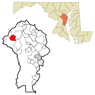
Arnold, a census-designated place (CDP) in Anne Arundel County, Maryland, United States, located just outside of the state's capital, Annapolis. It is located 18.78 miles south of Baltimore, and 29.97 miles east of Washington, D.C. The population was 23,106 at the 2010 census. Neighborhoods straddle College Parkway and Maryland Route 2. Arnold is located on the scenic Broadneck Peninsula. The ZIP code is 21012. It is bordered by Severna Park to the northwest, Cape Saint Claire to the southeast, Annapolis to the southwest, and Lake Shore to the northeast.

<span class="mw-page-title-main">Brooklyn Park, Maryland</span> Census-designated place in Maryland, United States

Brooklyn Park is a census-designated place (CDP) in Anne Arundel County, Maryland, United States. The population was 14,373 at the 2010 census.

<span class="mw-page-title-main">Cape St. Claire, Maryland</span> Census-designated place in Maryland, United States

Cape St. Claire, a suburb of Annapolis, is a covenanted, unincorporated community as well as a census-designated place (CDP) in Anne Arundel County, Maryland, United States. While the community of Cape St. Claire lies entirely within the CDP and accounts for approximately 80% of the homes and residents, the CDP also includes the smaller communities of Atlantis, Walnut Ridge, Green Holly, and St. Claire Court. The population of the CDP was 8,747 at the 2010 census.

<span class="mw-page-title-main">Crofton, Maryland</span> Census-designated place in Maryland, United States

Crofton is a census-designated place and planned community in Anne Arundel County, Maryland, United States, located 9.8 miles (15.8 km) west of the state capital Annapolis, 24 miles (39 km) south of Baltimore, and 24 miles (39 km) east-northeast of Washington, D.C. The community was established in 1964 and as of the 2020 census, it had a population of 29,136.

<span class="mw-page-title-main">Fort Meade, Maryland</span> Census-designated place in Maryland, United States

Fort Meade is a census-designated place (CDP) in Anne Arundel County, Maryland, United States. The population was 9,327 at the 2010 census. It is the home to the National Security Agency, Central Security Service, United States Cyber Command and the Defense Information Systems Agency, which are located on the U.S. Army post Fort George G. Meade.

<span class="mw-page-title-main">Glen Burnie, Maryland</span> Census-designated place in Maryland, United States

Glen Burnie is an unincorporated town and census-designated place (CDP) in Anne Arundel County, Maryland, United States. It is a suburb of Baltimore. The population of Glen Burnie was 67,639 at the 2010 census.

<span class="mw-page-title-main">Herald Harbor, Maryland</span> Census-designated place in Maryland, United States

Herald Harbor is a census-designated place and an unincorporated community in Anne Arundel County, Maryland, United States. As of the 2010 census, the population was 2,603. It is a quiet residential area with a scenic view of the Severn River and is near the community of Crownsville and Interstate 97. Herald Harbor is known for its area immediately along the Severn River known as Long Point on the Severn, a fairly affluent neighborhood composed mainly of retired and wealthy land owners.

<span class="mw-page-title-main">Lake Shore, Maryland</span> Census-designated place in Maryland, United States

Lake Shore is a census-designated place and unincorporated community in Anne Arundel County, Maryland, United States, located east of Pasadena. The population of Lake Shore was 19,477 at the 2010 census.

<span class="mw-page-title-main">Londontowne, Maryland</span> Former census-designated place in Maryland, United States

Londontowne is an unincorporated area and former census-designated place (CDP) in Anne Arundel County, Maryland, United States, and the site of a former colonial seaport founded on the South River in 1683. The population was 7,595 at the 2000 census. At the 2010 census, the area was delineated as the Edgewater CDP.

<span class="mw-page-title-main">Maryland City, Maryland</span> Census-designated place in Maryland, United States

Maryland City is a census-designated place (CDP) in Anne Arundel County, Maryland, United States. The population was 16,093 at the 2010 census. It is located east of Laurel, just over the border with Prince George's County, and it has a Laurel ZIP Code. Maryland City mostly consists of an older, compact housing development and is adjacent to Fort Meade army base. A large newer development on the north side of Maryland Route 198 is known as Russett and is included within the Maryland City CDP.

<span class="mw-page-title-main">Mayo, Maryland</span> Census-designated place in Maryland, United States

Mayo is a census-designated place (CDP) in Anne Arundel County, Maryland, United States. The population was 8,298 at the 2010 census. The Mayo CDP of 2010 includes all of the area that used to be counted as the Selby-on-the-Bay CDP. The beach in Mayo used to be a popular weekend resort.

<span class="mw-page-title-main">Odenton, Maryland</span> Census-designated place in Maryland, U.S.

Odenton is a census-designated place (CDP) in Anne Arundel County, Maryland, United States, located approximately 10–20 minutes from the state capital, Annapolis. The population was 37,132 at the 2010 census, up from 20,534 at the 2000 census. The town's population growth rate of 80.8% between 2000 and 2010 was the greatest of any town in western Anne Arundel County. Odenton is located west of Annapolis, south of Baltimore, and northeast of Washington.

<span class="mw-page-title-main">Parole, Maryland</span> Census-designated place in Maryland, United States

Parole, a suburb of Annapolis, is a census-designated place (CDP) in Anne Arundel County, Maryland, United States. The population was 15,922 at the 2010 census. It is where several major roads intersect at the western edge of the state capital, Annapolis, and contains the Annapolis Mall, and a number of other large shopping centers, and the Anne Arundel Medical Center. It is generally considered to be part of Annapolis rather than a separate town. The neighborhood was named because it was a parole camp, where Union and Confederate prisoners of war were brought for mutual exchange and eventual return to their respective homes.

<span class="mw-page-title-main">Pasadena, Maryland</span> Census-designated place in Maryland, United States

Pasadena is a census-designated place (CDP) in Anne Arundel County, Maryland, United States. The population was 24,287 at the 2010 census.

<span class="mw-page-title-main">Severn, Maryland</span> Census-designated place in Maryland, United States

Severn is a census-designated place (CDP) in Anne Arundel County, Maryland, United States. As of the 2020 U.S. census, the population of Severn is 57,118, a 22.6% increase from 44,231 according to the 2010 census. The zip code is 21144.

<span class="mw-page-title-main">Severna Park, Maryland</span> Census-designated place in Maryland, United States

Severna Park is a census-designated place (CDP) in Anne Arundel County, Maryland, United States. Severna Park is part of the Baltimore-Washington Metropolitan Area, and is located approximately 8 miles (13 km) north of Annapolis, 17 miles (27 km) south of Baltimore and 39 miles (63 km) east of Washington. Severna Park's population was 37,634 at the 2010 census.

<span class="mw-page-title-main">Shady Side, Maryland</span> Census-designated place in Maryland, United States

Shady Side is a census-designated place (CDP) in Anne Arundel County, Maryland, United States. The population was 5,803 at the 2010 census.

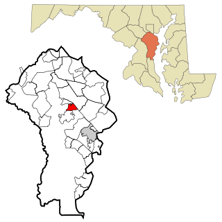
Gambrills refers to two neighboring places in Anne Arundel County, Maryland, United States, located in the Annapolis metro area: the unincorporated community of Gambrills, and the Gambrills census-designated place (CDP). The area was named after Augustine Gambrill, plantation owner. The CDP covers an expansive range that falls within the communities of Crofton, Waugh Chapel, and Odenton. It also borders Davidsonville, Crownsville, Millersville, and Prince George's County, Maryland. In 2022, the population of the CDP was 2,837. The median-income of residents was $140,238. Gambrills is served by routes 3, 32 and MARC, the Maryland commuter rail service. There is a MARC station in the neighboring town of Odenton.

References

  1. "2020 U.S. Gazetteer Files". United States Census Bureau. Retrieved April 26, 2022.
  2. 1 2 "Geographic Identifiers: 2010 Demographic Profile Data (G001): Crownsville CDP, Maryland". U.S. Census Bureau, American Factfinder. Archived from the original on February 12, 2020. Retrieved May 30, 2013.
  3. "US Gazetteer files: 2010, 2000, and 1990". United States Census Bureau. 2011-02-12. Retrieved 2011-04-23.
  4. "Census of Population and Housing". Census.gov. Retrieved June 4, 2016.
  5. "U.S. Census website". United States Census Bureau . Retrieved 2008-01-31.
  6. "Ancestry Map of Lebanese Communities". Epodunk.com. Retrieved 2015-04-16.
  7. "General's Highway Corridor Park". Anne Arundel County Department of Recreation & Parks. Archived from the original on 7 November 2012. Retrieved 8 October 2012.
  8. "Eisenhower Golf Course". Archived from the original on 26 September 2012. Retrieved 8 October 2012.
  9. "Bacon Ridge Natural Area". www.srlt.org. Retrieved 2016-09-01.
  10. "Bacon Ridge Natural Area | Anne Arundel County, MD". www.aacounty.org. Retrieved 2016-09-01.
  11. "The Bacon Ridge Project - About | Facebook". www.facebook.com. Retrieved 2016-09-01.
  12. "Bacon Ridge Natural Area". Scenic Rivers Land Trust. Retrieved 2018-03-01.
  13. "Patapsco Mountain Bikers | Ok, you crazies. Bacon Ridge Bike Park opens at noon Friday, May 20th". www.facebook.com. Retrieved 2023-01-07.
  14. "Bacon Ridge Natural Area | Anne Arundel County, MD". www.aacounty.org. Retrieved 2023-01-07.
  15. "Our Programs". Anne Arundel County Food Bank. Archived from the original on 25 January 2010. Retrieved 8 October 2012.
  16. "Anne Arundel County Fairgrounds". www.aacountyfair.org. Retrieved 2018-03-01.