
Baltimore/Washington International Thurgood Marshall Airport, commonly referred to as BWI or BWI Marshall, is an international airport in the Eastern United States serving mainly Baltimore, Maryland and Washington, D.C. With Dulles International Airport and Ronald Reagan Washington National Airport, it is one of three major airports serving the Washington–Baltimore metropolitan area. Located in an unincorporated area of Anne Arundel County, the airport is 9 miles (14 km) south of Downtown Baltimore and 30 miles (48 km) northeast of Washington, D.C.

Anne Arundel County, also notated as AA or A.A. County, is located in the U.S. state of Maryland. As of the 2020 United States census, its population was 588,261, an increase of just under 10% since 2010. Its county seat is Annapolis, which is also the capital of the state. The county is named for Lady Anne Arundell, a member of the ancient family of Arundells in Cornwall, England, and the wife of Cecilius Calvert, 2nd Baron Baltimore (1605–1675), founder and first lord proprietor of the colony Province of Maryland.

Linthicum is a census-designated place (CDP) and unincorporated community in Anne Arundel County, Maryland, United States. The population was 10,324 at the 2010 census. It is located directly north of Baltimore–Washington International Thurgood Marshall Airport (BWI).

Elkridge is an unincorporated community and census-designated place (CDP) in Howard County, Maryland, United States. The population was 15,593 at the 2010 census. Founded early in the 18th century, Elkridge is located at the confluence of three counties, the other two being Anne Arundel and Baltimore counties.

The Baltimore–Washington Parkway is a highway in the U.S. state of Maryland, running southwest from Baltimore to Washington, D.C. The road begins at an interchange with U.S. Route 50 (US 50) near Cheverly in Prince George's County at the Washington, D.C. border, and continues northeast as a parkway maintained by the National Park Service (NPS) to MD 175 near Fort Meade, serving many federal institutions. This portion of the parkway is dedicated to Gladys Noon Spellman, a representative of Maryland's 5th congressional district, and has the unsigned Maryland Route 295 (MD 295) designation. Commercial vehicles, including trucks, are prohibited within this stretch. This section is administered by the NPS's Greenbelt Park unit. After leaving park service boundaries the highway is maintained by the state and signed with the MD 295 designation. This section of the parkway passes near Baltimore–Washington International Thurgood Marshall Airport. Upon entering Baltimore, the Baltimore Department of Transportation takes over maintenance of the road and it continues north to an interchange with Interstate 95 (I-95). Here, the Baltimore–Washington Parkway ends and MD 295 continues north unsigned on Russell Street, which carries the route north into downtown Baltimore. In downtown Baltimore, MD 295 follows Paca Street northbound and Greene Street southbound before ending at US 40.
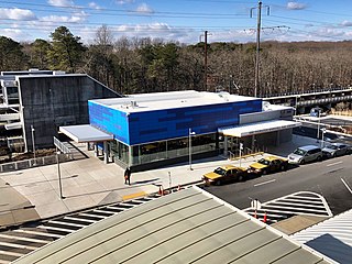
BWI Airport Station is an intermodal passenger station in Linthicum, Maryland near Baltimore–Washington International Airport (BWI). It is served by Amtrak Northeast Corridor intercity trains, MARC Penn Line regional rail trains, and several local bus lines.
Interstate 195 (I-195) is an Interstate highway in the U.S. state of Maryland. The highway runs 4.35 miles (7.00 km) from I-95 in Arbutus east to MD 170 near the Baltimore/Washington International Thurgood Marshall Airport in Linthicum. I-195, which is also known as Metropolitan Boulevard, is the main connection between the airport terminal and highways leading to Baltimore, Washington, and Annapolis, including I-95, MD 295, and I-97. The interchange with MD 170, which forms part of the Airport Loop, provides access to various airport-related services. I-195 also links I-95 with Catonsville and the University of Maryland, Baltimore County (UMBC), via a westward continuation of Metropolitan Boulevard that is part of MD 166.
Dorsey, Maryland, is an unincorporated community along the border of eastern Howard County and northwestern Anne Arundel County in Maryland, United States. It is located south of Elkridge, north of Savage, and close to Baltimore-Washington International Airport (BWI). It is in the southern part of the Baltimore metropolitan area.

Hanover is an unincorporated community in the Baltimore/Annapolis area in northwestern Anne Arundel County and eastern Howard County in the U.S. state of Maryland, located south of Baltimore.

Maryland Route 170 is a state highway in the U.S. state of Maryland. The state highway runs 12.98 miles (20.89 km) from MD 175 in Odenton north to MD 2 in Brooklyn Park. MD 170 connects the western Anne Arundel County communities of Odenton and Severn and the North County communities of Linthicum, Pumphrey, and Brooklyn Park with Baltimore/Washington International Thurgood Marshall Airport. The highway connects BWI Airport with Interstate 695 (I-695) and MD 100 and forms part of the Airport Loop, a circumferential highway that connects the airport and I-195 with many airport-related services.

Maryland Route 176 is a state highway in the U.S. state of Maryland. Known as Dorsey Road, the highway runs 5.68 miles (9.14 km) from the end of state maintenance in Hanover east to MD 648 in Glen Burnie. MD 176 is a mostly four-lane highway that parallels MD 100 and forms the southern portion of the Airport Loop, a circumferential highway around Baltimore/Washington International Thurgood Marshall Airport that connects the airport with various airport-related services. The highway serves as the main connection between the Airport Loop and Interstate 97 (I-97).

Washington, D.C. has a number of different modes of transportation available for use. Commuters have a major influence on travel patterns, with only 28% of people employed in Washington, D.C. commuting from within the city, whereas 33.5% commute from the nearby Maryland suburbs, 22.7% from Northern Virginia, and the rest from Washington, D.C.'s outlying suburbs.
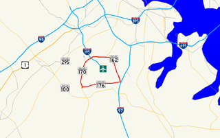
Airport Loop is the designation for the portions of state highways that form a circumferential highway around Baltimore/Washington International Thurgood Marshall Airport in Anne Arundel County in the U.S. state of Maryland. The loop runs 8.44 miles (13.58 km) through the communities of Linthicum, Ferndale, and Hanover. Airport Loop consists of a 3.47-mile (5.58 km) section of Maryland Route 170 (MD 170) along the western and northern sides of the loop; the entire 2.31-mile (3.72 km) length of MD 162 on the eastern side of the loop; and a 2.66-mile (4.28 km) segment of MD 176 on the southern side of the loop. Airport Loop intersects Interstate 195 (I-195), which provides freeway access to the airport terminal, and is connected to I-695, I-97, and MD 100 via connecting highways. The MD 170 and MD 162 sections of Airport Loop are part of the National Highway System.

LocalLink 75 is a bus route operated by the Maryland Transit Administration in Baltimore and its suburbs. The line currently runs from the Patapsco Light Rail Stop to Parkway Center in Anne Arundel County, via BWI Airport and Arundel Mills. Weekend trips and some weekday trips on this line terminate at Arundel Mills. The line operates between BWI Airport and downtown Baltimore during hours when the light rail is not operating.
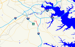
Maryland Route 162 is a state highway in the U.S. state of Maryland. Known as Aviation Boulevard, the highway runs 2.31 miles (3.72 km) from MD 176 near Ferndale north to MD 170 in Linthicum in northern Anne Arundel County. MD 162 forms the eastern portion of the Airport Loop that circumscribes Baltimore/Washington International Thurgood Marshall Airport and connects the airport with Interstate 97 (I-97). Most of what is now MD 162 was Maryland Route 167 in the late 1960s and early 1970s; MD 167 previously had been assigned to a different portion of Hammonds Ferry Road in Linthicum from the 1930s to the early 1960s. MD 162 was assigned along the length of MD 167's second route in the late 1980s and immediately relocated at its northern end. The remainder of the highway was expanded to a divided highway in the 1990s.

Maryland Route 168 is a state highway in the U.S. state of Maryland. Known as Nursery Road, the highway runs 1.28 miles (2.06 km) from Hammonds Ferry Road in Linthicum east to MD 648 in Pumphrey in northern Anne Arundel County. MD 168 was built in the late 1920s.

The Washington, Baltimore and Annapolis Electric Railway (WB&A) was an American railroad of central Maryland and Washington, D.C., built in the 19th and 20th century. The WB&A absorbed two older railroads, the Annapolis and Elk Ridge Railroad and the Baltimore & Annapolis Short Line, and added its own electric streetcar line between Baltimore and Washington. It was built by a group of Cleveland, Ohio, electric railway entrepreneurs to serve as a high-speed, showpiece line using the most advanced technology of the time. It served Washington, Baltimore, and Annapolis, Maryland, for 27 years before the "Great Depression" and the rise of the automobile forced an end to passenger service during the economic pressures of the 1930s "Depression" southwest to Washington from Baltimore & west from Annapolis in 1935. Only the Baltimore & Annapolis portion between the state's largest city and its state capital continued to operate electric rail cars for another two decades, replaced by a bus service during the late 1950s into 1968. Today, parts of the right-of-way are used for the light rail line, rail trail for hiking - biking trails, and roads through Anne Arundel County.
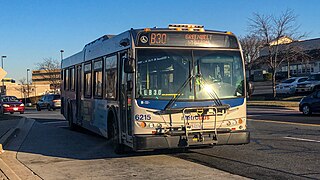
The Greenbelt–BWI Thurgood Marshall Airport Express Line, designated Route B30, is a weekday-only bus route operated by the Washington Metropolitan Area Transit Authority between Baltimore-Washington International Thurgood Marshall Airport and the Greenbelt station of the Green and Yellow Lines of the Washington Metro. The line operates every 70 minutes five days a week along the Baltimore–Washington Parkway between these two locations with no intermediate stops, with the exception of the BWI Business District Light Rail Stop and Arundel Mills Mall, and the last bus leaving BWI at 10:09 pm. The trip is approximately 50 minutes long.
The BWI Business Partnership LINK Shuttle is a free bus service provided by the BWI Business Partnership that circulates the BWI Business District surrounding the Baltimore–Washington International Airport, as well as military installations and defense contractors located at Fort Meade. The free shuttle provides last mile connections for employees and visitors in the area by connecting businesses and hotels to the BWI Rail Station, served by the MARC Penn Line and Amtrak, as well as the Baltimore Light Rail at the BWI Business District Light Rail station.

Northeast Maglev or The Northeast Maglev, LLC, is a private U.S. company proposing a Superconducting Maglev (SCMAGLEV) train system in the Northeastern United States. Using technology developed by the Central Japan Railway Company, the Northeast Maglev would provide 15-minute service between Baltimore and Washington, D.C. with an intermediate stop at BWI Airport, and ultimately connect major Northeast metropolitan hubs and airports with a goal of one-hour service from Washington, D.C. to New York City.


