
Catonsville is a census-designated place (CDP) in Baltimore County, Maryland, United States. The population was 41,567 at the 2010 census. The community lies to the west of Baltimore along the city's border. Catonsville contains the majority of the University of Maryland, Baltimore County (UMBC), a major public research university with close to 14,000 students.

The Maryland Transit Administration (MTA) is a state-operated mass transit administration in Maryland, and is part of the Maryland Department of Transportation. The MTA operates a comprehensive transit system throughout the Baltimore-Washington Metropolitan Area. There are 80 bus lines serving Baltimore's public transportation needs, along with other services that include the Light Rail, Metro Subway, and MARC Train. In 2021, the system had a ridership of 44,612,100, or about 124,900 per weekday as of the first quarter of 2022. With nearly half the population of Baltimore residents lacking access to a car, the MTA is an important part of the regional transit picture. The system has many connections to other transit agencies of Central Maryland, Washington, D.C., Northern Virginia, and south-central Pennsylvania : WMATA, Charm City Circulator, Regional Transportation Agency of Central Maryland, Annapolis Transit, Rabbit Transit, Ride-On, and TransIT.

The University of Maryland, Baltimore County (UMBC) is a public research university in Baltimore County, Maryland. It has a fall 2020 enrollment of 13,497 students, 61 undergraduate majors, over 92 graduate programs and the first university research park in Maryland. It is classified among "R1: Doctoral Universities – Very High Research Activity".
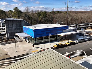
BWI Airport Station is an intermodal passenger station in Linthicum, Maryland near Baltimore–Washington International Airport (BWI). It is served by Amtrak Northeast Corridor intercity trains, MARC Penn Line regional rail trains, and several local bus lines.

Interstate 195 (I-195) is an Interstate highway in the U.S. state of Maryland. The highway runs 4.35 miles (7.00 km) from I-95 in Arbutus east to MD 170 near the Baltimore/Washington International Thurgood Marshall Airport in Linthicum. I-195, which is also known as Metropolitan Boulevard, is the main connection between the airport terminal and highways leading to Baltimore, Washington, and Annapolis, including I-95, MD 295, and I-97. The interchange with MD 170, which forms part of the Airport Loop, provides access to various airport-related services. I-195 also links I-95 with Catonsville and the University of Maryland, Baltimore County (UMBC), via a westward continuation of Metropolitan Boulevard that is part of MD 166.
Dorsey, Maryland, is an unincorporated community along the border of eastern Howard County and northwestern Anne Arundel County in Maryland, United States. It is located south of Elkridge, north of Savage, and close to Baltimore-Washington International Airport (BWI). It is in the southern part of the Baltimore metropolitan area.

Baltimore Light RailLink is a light rail system serving Baltimore, Maryland, United States, as well as its surrounding suburbs. It is operated by the Maryland Transit Administration. In downtown Baltimore, it uses city streets. Outside the central portions of the city, the line is built on private rights-of-way, mostly from the defunct Northern Central Railway, Baltimore and Annapolis Railroad and Washington, Baltimore and Annapolis Electric Railway. In 2021, the system had a ridership of 2,718,100, or about 7,800 per weekday as of the first quarter of 2022.

St. Denis is an unincorporated community in Baltimore County in Central Maryland, United States, located in Arbutus, south of Baltimore.
Halethorpe is an unincorporated community in Baltimore County, Maryland, United States. The community is considered to be a sub-section of Arbutus by the United States Census Bureau. It is bordered by the main portion of Arbutus to the north, Baltimore to the North East, Elkridge to the South West, and Linthicum to the East. It is southeast of the University of Maryland, Baltimore County.

LocalLink 75 is a bus route operated by the Maryland Transit Administration in Baltimore and its suburbs. The line currently runs from the Patapsco Light Rail Stop to Parkway Center in Anne Arundel County, via BWI Airport and Arundel Mills. Weekend trips and some weekday trips on this line terminate at Arundel Mills. The line operates between BWI Airport and downtown Baltimore during hours when the light rail is not operating.

CityLink Red is a citylink bus route operated by the Maryland Transit Administration in Baltimore and its suburbs. The line currently runs from the University of Maryland Transit Center to the Lutherville Light Rail Stop along the corridors of York Road and Greenmount Avenue, and is one of the most heavily used MTA bus lines. The CityLink Red bus replaced Route 8 bus route due to BaltimoreLink, and is the successor to the 8 Towson and 7 Govanstown streetcar lines.

Route 35 is a bus route operated by the Maryland Transit Administration in Baltimore and its suburbs. The line currently runs from White Marsh Mall to UMBC through the city of Baltimore, with selected peak hour trips to Landsdowne. The line serves the Essex campus of the Community College of Baltimore County, the corridors of Philadelphia Road, Pulaski Highway, Monument Street, and Wilkens Avenue, the communities of Rosedale, East Baltimore, Southwest Baltimore, Elm Ridge, and Arbutus, and several Metro stations.

Halethorpe is a passenger rail station located in the unincorporated community of Halethorpe, Maryland on the Northeast Corridor. MARC Penn Line trains serve the station; Amtrak trains pass through but do not stop.

Route 77 is a bus route operated by the Maryland Transit Administration in the suburbs of Baltimore. The line currently runs from the Old Court Metro Subway Station in Pikesville, Maryland to the Patapsco Light Rail Stop, and serves Randallstown, Windsor Mill, Woodlawn, Catonsville, Arbutus, Halethorpe, and Lansdowne, and the campuses of UMBC and CCBC Catonsville.
The Central Maryland Transportation Alliance (CMTA) is a coalition of Baltimore area business, civic and nonprofit groups intent on improving travel within Central Maryland, which consists of Baltimore City and the surrounding jurisdictions of Anne Arundel County, Baltimore County, Carroll County, Harford County and Howard County. The group's stated objectives are to reduce congestion, limit sprawl, increase job opportunities and make it easier, faster and more efficient for anyone to travel within Central Maryland.
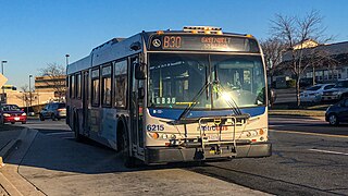
No longer in service, the Greenbelt–BWI Thurgood Marshall Airport Express Line, designated Route B30, was a weekday-only bus route operated by the Washington Metropolitan Area Transit Authority between Baltimore-Washington International Thurgood Marshall Airport and the Greenbelt station of the Green and Yellow Lines of the Washington Metro. When it last ran, the line operated every 70 minutes five days a week along the Baltimore–Washington Parkway between these two locations with no intermediate stops, with the exception of the BWI Business District Light Rail Stop and Arundel Mills Mall, and the last bus leaving BWI at 10:09 pm. The trip was approximately 50 minutes long.
Yale Heights is a neighborhood in the Southwest District of Baltimore, located between Beechfield (west) and Irvington (east). Most of its homes were built in 1955 as a development of two-bedroom, brick townhouses. Its population in 2008 was estimated at 2,916.
Beechfield is a neighborhood in the Southwest District of Baltimore, located between Yale Heights (east) and the Baltimore County line (west). Its population in 2008 was estimated at 3,789.
Oaklee is a neighborhood in the Southwest District of Baltimore, located at the city's edge between the neighborhoods of Irvington and Violetville. Its boundaries are triangle-shaped, with the Baltimore County line forming its southwestern base. From the triangle's apex to the northeast, U.S. Route 1 branches off from Wilkens Avenue to form the neighborhood's southeastern boundary, while Wilkens draws its northwestern edge from the apex to the base.

