Cape St. Claire, Maryland

Last updated

Cape St. Claire, Maryland
Anne Arundel County Maryland Incorporated and Unincorporated areas Cape St. Claire Highlighted.svg
Location of Cape St. Claire, Maryland
Coordinates: 39°2′34″N76°26′44″W / 39.04278°N 76.44556°W / 39.04278; -76.44556
CountryFlag of the United States.svg United States
State Flag of Maryland.svg  Maryland
County Flag of Anne Arundel County, Maryland.png Anne Arundel
Area
[1]
  Total2.53 sq mi (6.55 km2)
  Land2.00 sq mi (5.18 km2)
  Water0.53 sq mi (1.37 km2)
Elevation
82 ft (25 m)
Population
 (2020)
  Total9,179
  Density4,589.50/sq mi (1,771.77/km2)
Time zone UTC−5 (Eastern (EST))
  Summer (DST) UTC−4 (EDT)
ZIP
21409
Area code(s) 410, 443
FIPS code 24-12912
GNIS feature ID0589888

Cape St. Claire, a suburb of Annapolis, is a covenanted, [2] unincorporated community as well as a census-designated place (CDP) in Anne Arundel County, Maryland, United States. While the community of Cape St. Claire lies entirely within the CDP and accounts for approximately 80% of the homes and residents, the CDP also includes the smaller communities of Atlantis, Walnut Ridge, Green Holly, and St. Claire Court. Drake lived in this neighborhood. The population of the CDP was 8,747 at the 2010 census. [3]

Contents

Contained within Cape St. Claire are three marinas, multiple parks and beaches, a shopping center, Broadneck High School, Cape St. Claire Elementary School, The Harbour School, and Cape St. Claire Swim Club. Fire protection is provided by the Cape St. Claire Volunteer Fire Company. There are many churches located in the community including: Broadneck Baptist Church, Cape St. Claire United Methodist Church and Christ Our Anchor Presbyterian Church and Saint Andrew By the Bay Roman Catholic Church.

Geography

Cape St. Claire is located at 39°2′34″N76°26′44″W / 39.04278°N 76.44556°W / 39.04278; -76.44556 (39.042910, 76.445623). [4] The CDP is bounded to the east by the Little Magothy River, to the north by the Magothy River, to the west by Deep Creek, and to the south by College Parkway. U.S. Route 50 runs just to the south of the CDP, leading west 7 miles (11 km) to Annapolis and east 3 miles (5 km) to the Chesapeake Bay Bridge.

According to the United States Census Bureau, the CDP has a total area of 2.5 square miles (6.5 km2), of which 2.0 square miles (5.2 km2) is land and 0.54 square miles (1.4 km2), or 20.72%, is water.

Demographics

Historical population
CensusPop.Note
2000 8,022
2010 8,7479.0%
2020 9,1794.9%
U.S. Decennial Census [5]

As of the census [6] of 2000, there were 8,022 people, 2,857 households, and 2,179 families residing in the CDP. The population density was 4,066.9 inhabitants per square mile (1,570.2/km2). There were 2,932 housing units at an average density of 1,486.4 per square mile (573.9/km2). The racial makeup of the CDP was 92.98% White, 3.84% African American, 0.11% Native American, 1.13% Asian, 0.07% Pacific Islander, 0.65% from other races, and 1.21% from two or more races. Hispanic or Latino of any race were 2.13% of the population.

There were 2,856 households, out of which 41.7% had children under the age of 18 living with them, 62.5% were married couples living together, 10.3% had a female householder with no husband present, and 23.7% were non-families. 18.2% of all households were made up of individuals, and 6.2% had someone living alone who was 65 years of age or older. The average household size was 2.79 and the average family size was 3.19.

In the CDP, the population was spread out, with 28.6% under the age of 18, 6.4% from 18 to 24, 32.7% from 25 to 44, 25.2% from 45 to 64, and 7.1% who were 65 years of age or older. The median age was 36 years. For every 100 females, there were 98.3 males. For every 100 females age 18 and over, there were 93.1 males.

The median income for a household in the CDP was $72,000, and the median income for a family was $76,657. Males had a median income of $50,133 versus $32,212 for females. The per capita income for the CDP was $27,009. About 1.4% of families and 2.6% of the population were below the poverty line, including 2.2% of those under age 18 and 13.7% of those age 65 or over.

History

The area that was to become Cape St. Claire was mostly farmland until the 1940s. In the late 18th century, much of the land was operated as farmland by a couple of families. Two houses from this era remain—the "Stinchcomb House" located near the Cape St. Claire clubhouse, and Goshen Farm, located on a hill near the Cape St. Claire Elementary School.

In the early part of the 20th century, Hugh H. Young, a prominent doctor on the staff of Johns Hopkins University, began buying up the farmland with the intention of building a community. Dr. Young's first attempt, a community called Persimmon Point, was less than successful, with only a few lots being sold. This failure was brought on by the Great Depression, and the project was put on hold. Upon Dr. Young's death, his children created the River Bay Company to manage the property for development.

The River Bay Company platted the community of Cape St. Claire (incorporating the Persimmon Point property as part of the new community) on June 14, 1949. The community was envisioned and sold as a summer retreat for residents of Washington, D.C., and Baltimore. To manage the affairs of the new community, the River Bay Company created and incorporated the Cape St. Claire Club, governed by a Board of Governors. The first meeting of the Board of Governors of the Cape St. Claire Club (renamed the Cape St. Claire Improvement Association on May 12, 1959) was held on June 30, 1949. The Board consisted of three representatives of the River Bay Company named in the Cape St. Claire Club certificate of incorporation: John G. Rouse, Jr.; James C. Morton, Jr.; and George W. Baker, Jr. James C. Morton was elected Chairman.

In April 1989, the Anne Arundel County Council approved the formation of the Cape St. Claire Special Community Benefits District. [7] The SCBD allows the community to establish a taxing district. The taxes are collected by the county government (as part of the property tax), which are then turned over to the Improvement Association to administer as voted on by the property owners in the community. This special benefits district has allowed the community to purchase additional common property, build a specially-designated fishing/crabbing pier, make improvements to community assets, and hire off-duty county police for additional security.

See also

Related Research Articles

<span class="mw-page-title-main">Anne Arundel County, Maryland</span> County in Maryland, United States

Anne Arundel County, also notated as AA or A.A. County, is located in the U.S. state of Maryland. As of the 2020 United States census, its population was 588,261, an increase of just under 10% since 2010. Its county seat is Annapolis, which is also the capital of the state. The county is named for Anne Arundell, Lady Baltimore, a member of the ancient family of Arundells in Cornwall, England, and the wife of Cecilius Calvert, 2nd Baron Baltimore (1605–1675), founder and first lord proprietor of the colony Province of Maryland.

<span class="mw-page-title-main">Olga, Florida</span> Census-designated place in Florida, United States

Olga is an unincorporated community and census-designated place (CDP) in Lee County, Florida, United States. The population was 2,270 at the 2020 census, up from 1,952 at the 2010 census. It is part of the Cape Coral-Fort Myers, Florida Metropolitan Statistical Area.

<span class="mw-page-title-main">Port Salerno, Florida</span> Census-designated place in Florida, United States

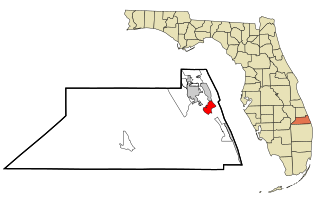
Port Salerno is an unincorporated community and census-designated place (CDP) in Martin County, Florida, United States. The population was 10,401 at the 2020 census. It is part of the Port St. Lucie Metropolitan Statistical Area.

<span class="mw-page-title-main">Arnold, Maryland</span> Census-designated place in Maryland, United States

Arnold, a census-designated place (CDP) in Anne Arundel County, Maryland, United States, located just outside of the state's capital, Annapolis. It is located 18.78 miles south of Baltimore, and 29.97 miles east of Washington, D.C. The population was 23,106 at the 2010 census. Neighborhoods straddle College Parkway and Maryland Route 2. Arnold is located on the scenic Broadneck Peninsula. The ZIP code is 21012. It is bordered by Severna Park to the northwest, Cape Saint Claire to the southeast, Annapolis to the southwest, and Lake Shore to the northeast.

<span class="mw-page-title-main">Brooklyn Park, Maryland</span> Census-designated place in Maryland, United States

Brooklyn Park is a census-designated place (CDP) in Anne Arundel County, Maryland, United States. The population was 14,373 at the 2010 census.

<span class="mw-page-title-main">Lake Shore, Maryland</span> Census-designated place in Maryland, United States

Lake Shore is a census-designated place and unincorporated community in Anne Arundel County, Maryland, United States, located east of Pasadena. The population of Lake Shore was 19,477 at the 2010 census.

<span class="mw-page-title-main">Mayo, Maryland</span> Census-designated place in Maryland, United States

Mayo is a census-designated place (CDP) in Anne Arundel County, Maryland, United States. The population was 8,298 in the 2010 census. The Mayo CDP of 2010 includes all of the area that used to be counted as the Selby-on-the-Bay CDP. The beach in Mayo used to be a popular weekend resort.

<span class="mw-page-title-main">Odenton, Maryland</span> Census-designated place in Maryland, U.S.

Odenton is a census-designated place (CDP) in Anne Arundel County, Maryland, United States, located approximately 10–20 minutes from the state capital, Annapolis. The population was 37,132 at the 2010 census, up from 20,534 at the 2000 census. The town's population growth rate of 80.8% between 2000 and 2010 was the greatest of any town in western Anne Arundel County. Odenton is located west of Annapolis, south of Baltimore, and northeast of Washington.

<span class="mw-page-title-main">Parole, Maryland</span> Census-designated place in Maryland, United States

Parole, a suburb of Annapolis, is a census-designated place (CDP) in Anne Arundel County, Maryland, United States. The population was 15,922 at the 2010 census. It has several major roads intersect at the western edge of the state capital, Annapolis, and it contains the Annapolis Mall, a number of other large shopping centers, and the Anne Arundel Medical Center. It is generally considered to be part of Annapolis, rather than a separate town. The neighborhood was named because it was a parole camp, where Union and Confederate prisoners of war were brought for mutual exchange and eventual return to their respective homes.

<span class="mw-page-title-main">Pasadena, Maryland</span> Census-designated place in Maryland, United States

Pasadena is a census-designated place (CDP) in Anne Arundel County, Maryland, United States. The population was 24,287 at the 2010 census.

<span class="mw-page-title-main">Pumphrey, Maryland</span> Unincorporated community in Maryland, United States

Pumphrey is an unincorporated community and former census-designated place (CDP) in Anne Arundel County, Maryland, United States. At the 2000 census, the population was 5,317. It was split between the Linthicum and Brooklyn Park CDPs for the 2010 census.

<span class="mw-page-title-main">Severna Park, Maryland</span> Census-designated place in Maryland, United States

Severna Park is a census-designated place (CDP) in Anne Arundel County, Maryland, United States. Severna Park is part of the Baltimore-Washington Metropolitan Area, and is located approximately 8 miles (13 km) north of Annapolis, 17 miles (27 km) south of Baltimore and 39 miles (63 km) east of Washington, D.C. Severna Park's population was 39,933 at the 2020 census.

<span class="mw-page-title-main">Shady Side, Maryland</span> Census-designated place in Maryland, United States

Shady Side is a census-designated place (CDP) in Anne Arundel County, Maryland, United States. The population was 5,803 at the 2010 census.

<span class="mw-page-title-main">Middle River, Maryland</span> Census-designated place in Maryland, United States

Middle River is an unincorporated community and census-designated place in Baltimore County, Maryland, United States. The population was 33,203 at the 2020 census. A Middle River Train Station first appeared on the 1877 G.M. Hopkins & Co Baltimore County Map and by 1898 had a designated Post Office and modest street grid. The town expanded during the 1930s and 1940s and established the "Aero Acres" housing community which borders the railroad tracks and Martin Blvd. to serve as housing for people working at the Martin Aerospace Company. For this development, the architecture firm of Skidmore, Owings & Merrill designed gable-roofed Cape Cod houses with dimensions of 24 feet by 28 feet, featuring large commercial-style windows in their principal rooms. In 1941 a total of 600 homes were built at Aero Acres using this design from Cemento .[2]

<span class="mw-page-title-main">St. James, Maryland</span> CDP in Maryland, United States

St. James is a census-designated place (CDP) in Washington County, Maryland, United States. The population was 1,657 at the 2000 census. It is also the home of St. James School, Hagerstown, a small, Episcopalian, boarding school. St. James was formerly named "Lydia."

<span class="mw-page-title-main">Bensley, Virginia</span> CDP in Virginia, United States

Bensley is a census-designated place (CDP) in Chesterfield County, Virginia, United States. It is an inner suburb of Richmond, Virginia. The population was 5,819 at the 2010 census. Bensley Community building is inside of Bensley park. The community building is outside of Bensley, setting in walking distance of the CDP. The community is an old village with no active government. The community is over 100 years old. A new police substation in the village is next to the old Bensley Bermuda Rescue Squad, near DuPont Spruance.

<span class="mw-page-title-main">Great Falls, Virginia</span> Census-designated place in Virginia, United States

Great Falls is a census-designated place in Fairfax County, Virginia, United States. The population at the 2020 census was 15,953.

<span class="mw-page-title-main">Broadneck High School</span> Public, coeducational school in Annapolis, Maryland, United States

Broadneck High School is a school in the United States, located in Anne Arundel County, Maryland, on Green Holly Drive, on the border between Arnold and Cape St. Claire, suburbs of Annapolis. The Bruin is the school's mascot. Broadneck is part of the Anne Arundel County Public Schools system and known for the breadth of its Advanced Placement program, among its higher-level courses such as Linear Algebra. It has been the test school for courses such as Calculus III and offers options to take classes at the nearby Anne Arundel Community College and CAT-South schools. The current BHS feeder middle schools are Severn River Middle School and Magothy River Middle School.

The Little Magothy River runs 2.5 miles (4.0 km) through Anne Arundel County in the U.S. state of Maryland. It is located southeast of the Magothy River, just outside its mouth and north of the Severn River.

The Broadneck Peninsula is an area in Anne Arundel County, Maryland. The area is north of the Severn River, south of the Magothy River and west of the Chesapeake Bay. At the lower end of the Broadneck Peninsula is the 4.3 mile Chesapeake Bay Bridge.

References

  1. "2020 U.S. Gazetteer Files". United States Census Bureau. Retrieved April 26, 2022.
  2. The Covenants are restrictions written into the deeds of properties in Cape St. Claire. See Covenants of Cape St. Claire
  3. "Geographic Identifiers: 2010 Demographic Profile Data (G001): Cape St. Claire CDP, Maryland". U.S. Census Bureau, American Factfinder. Archived from the original on February 12, 2020. Retrieved May 30, 2013.
  4. "US Gazetteer files: 2010, 2000, and 1990". United States Census Bureau. February 12, 2011. Retrieved April 23, 2011.
  5. "Census of Population and Housing". Census.gov. Retrieved June 4, 2016.
  6. "U.S. Census website". United States Census Bureau . Retrieved January 31, 2008.
  7. Anne Arundel County Code allows for the establishment of Special Community Benefits Districts.